
 GPS & GNSS
 Lidar scanning
 Total Station


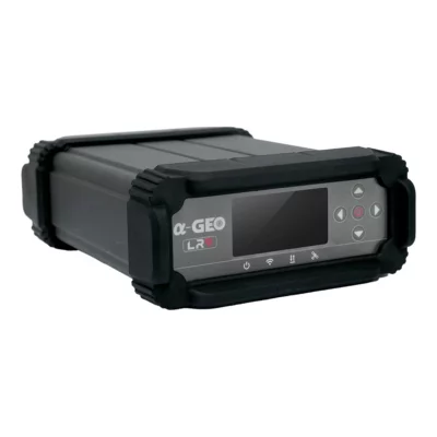
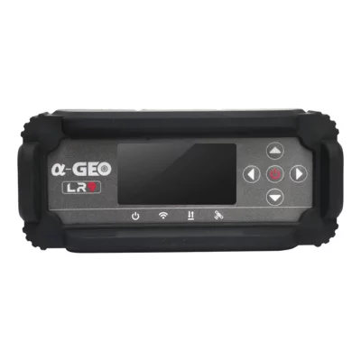


AlphaGeo LR9 High Performance GNSS Reference Receiver
This product is available
Get the best price for your setup
Contact our experts for the best possible price and configuration.
The AlphaGeo LR9 is a high-performance GNSS reference receiver for permanent CORS stations, deformation monitoring and other applications that require reliable, continuous positioning data. Its 1408-channel board tracks GPS, GLONASS, BeiDou, Galileo, QZSS and SBAS signals across multiple frequencies.
With millimetre-level static accuracy, centimetre-level RTK positioning and support for NTRIP, TCP/IP and RTCM 3.x, the LR9 can provide reference data to surveyors, construction teams, GIS professionals and monitoring systems. Integrated 4G, Wi-Fi, Ethernet and serial connectivity make it suitable for both network-connected installations and local data collection.
AlphaGeo LR9 Highlights
| GNSS tracking | 1408 channels with GPS, GLONASS, BeiDou, Galileo, QZSS and SBAS |
|---|---|
| Static accuracy | Horizontal ±(2.5 + 0.5 ppm) mm; vertical ±(5 + 0.5 ppm) mm |
| RTK accuracy | Horizontal ±(8 + 1 ppm) mm; vertical ±(15 + 1 ppm) mm |
| Communications | 4G, Wi-Fi, RJ45 Ethernet, RS232, NTRIP and TCP/IP |
| Data storage | 32GB raw-data storage with up to 180 days recording at 1Hz |
| Environmental protection | IP67 with an operating range from -40°C to +75°C |
Valued customers:










Find RTK Networks
Search NTRIP providers and connect to reliable RTK correction services.
Description
Reliable GNSS Data for Reference Stations and Monitoring
The AlphaGeo LR9 High Performance GNSS Reference Receiver is designed for fixed installations where positioning data must be collected and transmitted continuously. Typical applications include CORS network deployment, geohazard monitoring, structural movement monitoring and permanent survey-control infrastructure.
Unlike a conventional rover receiver that moves between survey points, the LR9 is intended to operate from a known, stable location. It records satellite observations and can distribute correction data to connected GNSS rovers, software platforms or monitoring systems. This gives surveyors, engineers and construction teams a dependable positioning reference across a project area.
Multi-Constellation and Multi-Frequency Signal Tracking
The LR9 uses 1408 channels to track GPS, GLONASS, BeiDou, Galileo, QZSS and SBAS signals. Multi-frequency tracking gives the receiver more observations to work with and helps maintain stable positioning when satellite visibility or atmospheric conditions are less than ideal.
Support for modern signals such as GPS L5, Galileo E5 and E6, and multiple BeiDou frequencies makes the receiver suitable for long-term reference infrastructure. It also helps reduce the effect of ionospheric delays and multipath interference, which can otherwise affect the consistency of GNSS measurements.
Precision for Static and Real-Time Applications
For static GNSS surveying, the LR9 provides specified horizontal accuracy of ±(2.5 + 0.5 ppm) mm and vertical accuracy of ±(5 + 0.5 ppm) mm. Its specified RTK accuracy is ±(8 + 1 ppm) mm horizontally and ±(15 + 1 ppm) mm vertically.
In practical terms, static observations can support high-precision control networks and movement analysis, while RTK output can provide centimetre-level corrections for site surveying, setting out, mapping and construction measurement. RTK initialization is specified at under 10 seconds on baselines shorter than 10 kilometres when operating conditions are suitable.
Built for CORS Networks
In a continuously operating reference station, the receiver remains installed at a surveyed control point and collects GNSS observations over long periods. The LR9 supports NTRIP and TCP/IP communication together with RTCM 3.x correction formats, allowing it to form part of an internet-connected RTK correction service.
This makes it relevant to survey businesses, construction companies, public authorities and GIS organisations that want to operate a local base station or build a wider correction network. Multiple rovers can use corrections from the reference infrastructure without placing a temporary base receiver on every job site.
Continuous Deformation and Geohazard Monitoring
The LR9 can also be used as part of a monitoring system for slopes, landslides, dams, bridges, buildings and other structures. A permanently installed receiver records repeated position measurements so monitoring software can identify gradual displacement or sudden movement.
GNSS monitoring is especially useful at locations where measurements are required continuously or where regular manual surveying would be difficult. The receiver supplies the positioning data, while alarms, analysis and reporting are managed by the connected monitoring platform.
Flexible Data Communication
The receiver includes 4G mobile connectivity, 802.11 b/g Wi-Fi, an RJ45 network connection and an RS232 interface. Dedicated connections are provided for the external GNSS antenna, 4G antenna, power supply and PPS output.
These options allow the LR9 to communicate through the most practical connection available at the installation site. Ethernet can be used at permanent facilities, while 4G can connect remote stations where a wired network is unavailable. NTRIP support enables correction data to be sent through the internet to compatible field receivers.
Local Storage for Long-Term Observation Data
Integrated 32GB storage records raw GNSS observations at a published sampling rate of 1Hz. AlphaGeo specifies capacity for up to 180 days of continuous raw-data recording at this rate, supported by circular FIFO storage management.
Local recording provides a valuable backup when a network connection is interrupted. The stored observations can also support post-processing, quality checks and longer-term displacement analysis.
Low-Power Operation and Backup Battery
The LR9 operates from a 9–36V DC supply and has a stated power consumption of no more than 2.5W. A built-in 20,000mAh battery supports continued operation during temporary power interruptions and can simplify deployment at sites using solar or other limited power sources.
Low consumption is particularly useful for remote reference and monitoring stations, where dependable operation matters more than frequent access to the equipment.
Designed for Permanent Outdoor Installations
The IP67-rated enclosure protects the receiver against dust and temporary water immersion. It is specified for operation from -40°C to +75°C and for storage from -55°C to +85°C. The unit measures 196 × 145 × 62 mm and weighs no more than 1.5kg.
A 2.42-inch industrial OLED screen displays system information directly at the receiver. Physical navigation buttons and separate power, Wi-Fi, data and satellite indicators allow technicians to check the station during installation or maintenance without relying entirely on an external controller.
Applications
- Permanent CORS and RTK reference stations
- Survey-control and construction reference networks
- Landslide, slope and debris-flow monitoring
- Bridge, dam, building and structural movement monitoring
- GIS positioning and mapping infrastructure
- Long-duration raw GNSS data collection
Who Is the AlphaGeo LR9 For?
The LR9 is intended for survey companies, engineering firms, construction organisations, monitoring specialists, GIS teams and public agencies that need a fixed GNSS receiver rather than a handheld rover. It is particularly suitable when measurements or correction data must remain available around the clock.
For organisations planning a new reference station or monitoring installation, Global GPS Systems can help assess the required antenna, power supply, communications, mounting hardware and compatible field receivers. Correct system design is important because the final performance of a permanent GNSS station also depends on antenna placement, site stability, satellite visibility and network configuration.
Datasheets & Manuals
Datasheets and manuals
Datasheets & manuals
Specifications
ALPHAGEO LR9 High-Performance GNSS Reference Receiver Specifications
Product Overview
| Manufacturer | ALPHAGEO |
|---|---|
| Model | LR9 |
| Product Type | High-performance GNSS reference receiver |
| Receiver Design | Split-design GNSS reference receiver |
| Positioning Technologies | Carrier-phase differential positioning, RTK and PPK |
| GNSS Architecture | Multi-constellation, multi-frequency signal tracking |
| GNSS Channel Count | 1408 channels |
| Primary Applications | CORS deployment, geohazard monitoring, structural health monitoring and continuous high-precision positioning |
GNSS Signal Tracking
| Satellite System | Supported Signals |
|---|---|
| GPS | L1 C/A, L2C, L2P, L5 |
| GLONASS | G1, G2, G3 |
| BeiDou (BDS) | B1, B1C, B2, B2a, B2b, B3 |
| Galileo | E1, E5a, E5b, E6 |
| QZSS | L1, L2, L5 |
| SBAS | L1 C/A |
GNSS Performance
| Cold Start Time | <60 seconds |
|---|---|
| Hot Start Time | <15 seconds |
| Signal Reacquisition Time | <2 seconds |
| RTK Initialization Time | <10 seconds with a baseline shorter than 10 km |
| Positioning Output Rate | 1 Hz |
| Anti-Interference Technology | Multi-frequency anti-jamming technology |
| Environmental Error Mitigation | Designed to mitigate ionospheric delay and multipath effects |
Positioning Accuracy
| Positioning Mode | Horizontal Accuracy | Vertical Accuracy |
|---|---|---|
| Static GNSS Surveying | ±(2.5 + 0.5 × 10⁻⁶ × D) mm | ±(5 + 0.5 × 10⁻⁶ × D) mm |
| RTK Surveying | ±(8 + 1 × 10⁻⁶ × D) mm | ±(15 + 1 × 10⁻⁶ × D) mm |
Communications and Data Protocols
| Communication Protocols | TCP/IP and NTRIP |
|---|---|
| Wi-Fi | IEEE 802.11 b/g |
| Cellular Network | Full-frequency, multi-band 4G GSM module |
| Differential Data Format | RTCM 3.x |
| Data Output Format | RTCM 3.x |
| Communication Architecture | Modular, industrial-grade communication architecture |
Physical Interfaces
| Interface | Quantity | Function or Notes |
|---|---|---|
| Power Supply Interface | 1 | External DC power input |
| LEMO-5 RS232 Interface | 1 | Serial data communication |
| GNSS Antenna Interface | 1 | External GNSS antenna connection |
| Wireless Interface | 1 | Wireless communication connection |
| 4G Antenna Interface | 1 | External cellular antenna connection |
| PPS Interface | 1 | Pulse-per-second timing output |
| RJ45 Network Interface | 1 | Wired Ethernet network connection |
| SIM Card Slot | Integrated | Used with the cellular communication module |
| USB Interface | USB 3.0 | Data connection referenced in the manufacturer brochure |
Data Storage
| Internal Storage | 32 GB industrial-grade storage |
|---|---|
| Storage Format | RAW observation data |
| Recording Sampling Rate | 1 Hz |
| Continuous Recording Capacity | Up to 180 days of raw observation data at a 1 Hz sampling rate |
| Buffer Management | Circular buffering with FIFO management |
Display and User Interface
| Display Type | Industrial-grade OLED |
|---|---|
| Display Size | 2.42 inches |
| Display Resolution | 128 × 64 pixels |
| Operating System | Customized embedded Linux OS |
| Physical Controls | Power, Esc, OK and navigation buttons |
| Status Indicators | Power, Wi-Fi, data and satellite indicators |
Electrical and Power
| External Power Input | 9–36 V DC |
|---|---|
| Internal Battery Capacity | 20,000 mAh |
| Power Consumption | ≤2.5 W |
| Typical Operating Consumption | <2.5 W |
| Sleep-Mode Consumption | Milliwatt-level power consumption |
| Battery Type | Industrial-grade, high-energy-density battery pack |
Physical Specifications
| Dimensions | 196 × 145 × 62 mm |
|---|---|
| Weight | ≤1.5 kg |
| Ingress Protection | IP67 water- and dust-resistant |
| Operating Temperature | -40°C to +75°C |
| Storage Temperature | -55°C to +85°C |
| Humidity | Up to 100% non-condensing |
Key Functions and Features
| Multi-Constellation Operation | Simultaneously supports GPS, GLONASS, BeiDou, Galileo, QZSS and SBAS signals |
|---|---|
| Multi-Frequency Tracking | Tracks multiple frequencies from each supported satellite constellation |
| Static Positioning | Millimetre-level static GNSS positioning capability |
| Dynamic Positioning | Centimetre-level RTK positioning capability |
| Interference Resistance | Multi-frequency anti-jamming design for operation in challenging signal environments |
| Continuous Monitoring | Low-power architecture, onboard battery and extended data storage support continuous reference-station and monitoring operation |
| Remote Data Communication | Supports wired Ethernet, Wi-Fi, 4G cellular and NTRIP-based correction-data transmission |
| Harsh-Environment Operation | IP67 enclosure and wide operating-temperature range |
Recommended Applications
| CORS Networks | Permanent GNSS reference-station and Continuously Operating Reference Station deployment |
|---|---|
| Geological Hazard Monitoring | Monitoring and early-warning systems for landslides, debris flows and related ground movement |
| Structural Health Monitoring | Continuous displacement and deformation monitoring of structures and infrastructure |
| Deformation Monitoring | Long-term, high-precision monitoring of terrain, slopes, buildings and engineered assets |
| GNSS Data Collection | Continuous raw GNSS observation recording for post-processing and analysis |
| RTK Correction Services | Generation and transmission of RTCM 3.x correction data over TCP/IP or NTRIP networks |
Specifications and package contents may vary by configuration, region or manufacturer update. Always check the current configuration before ordering.
FAQ
ALPHAGEO LR9 High-Performance GNSS Reference Receiver FAQ
Product Overview and Applications
What is the ALPHAGEO LR9 GNSS reference receiver?
The ALPHAGEO LR9 is a high-performance, split-design GNSS reference receiver developed for continuous high-precision positioning. It supports multi-constellation, multi-frequency satellite tracking and can be used for static positioning, RTK correction services, monitoring systems and permanent GNSS reference station installations.
What is the LR9 GNSS receiver used for?
The LR9 is designed for applications such as CORS station deployment, geological disaster monitoring, landslide and debris-flow early warning, structural health monitoring and other projects that require stable, continuous GNSS measurements.
Who typically uses the LR9 GNSS reference receiver?
The LR9 is suitable for surveying and mapping organizations, CORS network operators, geotechnical monitoring companies, engineering contractors, research institutions, infrastructure owners and government agencies responsible for deformation or natural-hazard monitoring.
Can the LR9 be used as a permanent GNSS base station?
Yes. The LR9 supports the communication protocols, external antenna connection, continuous raw-data recording and RTCM correction output required for permanent GNSS base stations and CORS infrastructure.
Can the LR9 be used for geological disaster monitoring?
Yes. The receiver is designed for continuous high-precision monitoring of ground movement in applications such as landslides, unstable slopes and debris-flow warning systems. Its rugged enclosure, low power consumption and multiple communication options support installation in remote monitoring locations.
Is the LR9 suitable for structural health monitoring?
Yes. The LR9 can be integrated into monitoring systems that measure long-term or real-time displacement of bridges, dams, buildings, towers and other engineered structures. The achievable accuracy depends on the monitoring method, antenna installation, satellite visibility, baseline length and site conditions.
GNSS Signals, Accuracy and Performance
Which satellite navigation systems does the LR9 support?
The LR9 supports GPS, GLONASS, BeiDou, Galileo, QZSS and SBAS signals. Its multi-constellation capability improves satellite availability and positioning reliability in demanding environments.
Which GNSS frequencies can the LR9 track?
The LR9 tracks GPS L1 C/A, L2C, L2P and L5; GLONASS G1, G2 and G3; BeiDou B1, B1C, B2, B2a, B2b and B3; Galileo E1, E5a, E5b and E6; QZSS L1, L2 and L5; and SBAS L1 C/A.
How many GNSS channels does the LR9 have?
The LR9 provides 1,408 GNSS tracking channels for receiving signals from multiple satellite constellations and frequencies simultaneously.
What positioning accuracy can the LR9 achieve?
For static GNSS surveying, the specified horizontal accuracy is ±(2.5 + 0.5 × 10⁻⁶ × D) mm and the vertical accuracy is ±(5 + 0.5 × 10⁻⁶ × D) mm. For RTK surveying, the specified horizontal accuracy is ±(8 + 1 × 10⁻⁶ × D) mm and the vertical accuracy is ±(15 + 1 × 10⁻⁶ × D) mm, where D represents the baseline distance.
How quickly does the LR9 initialize an RTK solution?
The specified RTK initialization time is less than 10 seconds when the baseline is shorter than 10 km. Actual initialization time may vary with satellite geometry, signal quality, atmospheric conditions, correction-data quality and the surrounding environment.
How does the LR9 maintain reliable positioning in difficult conditions?
The receiver uses multi-frequency GNSS tracking and anti-interference technology to reduce the effects of ionospheric delay, multipath and signal interference. Good antenna placement with a clear view of the sky remains important for achieving the best results.
Communication, Data and Integration
Does the LR9 support NTRIP?
Yes. The LR9 supports NTRIP and TCP/IP communication, allowing it to transmit or receive GNSS correction data through compatible network infrastructure.
Which GNSS correction and data formats does the LR9 support?
The LR9 supports RTCM 3.x differential correction and output formats. It also records GNSS observations in RAW format for storage, transfer and post-processing workflows.
What communication methods are available on the LR9?
The LR9 supports Ethernet through an RJ45 interface, RS232 communication, Wi-Fi 802.11 b/g and a full-frequency multi-band 4G GSM module. These options allow the receiver to be integrated into local, cellular and internet-based monitoring networks.
Which physical interfaces does the LR9 provide?
The receiver includes a power-supply interface, LEMO-5 RS232 interface, GNSS antenna interface, wireless interface, 4G antenna interface, PPS interface and RJ45 network interface. These connections support external antennas, data communication, timing and system integration.
How much internal storage does the LR9 have?
The LR9 has 32 GB of internal storage. According to the product specification, this can support approximately 180 days of continuous raw-data recording at a 1 Hz sampling rate, depending on the configured data and recording conditions.
Can the LR9 be integrated with existing CORS or monitoring software?
The LR9 is designed for integration through standard technologies including NTRIP, TCP/IP, RTCM 3.x, Ethernet and serial communication. Compatibility should be confirmed against the protocols, message types, connection settings and data formats required by the existing software platform.
Power, Installation and Environmental Protection
What power supply does the LR9 require?
The LR9 accepts a DC input voltage from 9 V to 36 V, providing flexibility for use with fixed power systems, external battery systems, solar installations and monitoring cabinets configured within the supported voltage range.
Does the LR9 have a built-in battery?
Yes. The LR9 includes a 20,000 mAh battery. Actual operating time depends on communication activity, connected accessories, environmental temperature, GNSS tracking conditions and system configuration.
How much power does the LR9 consume?
The specified power consumption is no more than 2.5 W. This low-power design is useful for permanent stations and remote monitoring systems where energy efficiency is important.
Is the LR9 waterproof and dustproof?
Yes. The LR9 has an IP67 ingress-protection rating, providing protection against dust and temporary water immersion under the conditions defined by the IP67 standard. Connectors, cables and the complete installation must also be properly sealed to preserve environmental protection.
What temperatures can the LR9 operate in?
The specified operating temperature range is −40°C to +75°C, while the storage temperature range is −55°C to +85°C. This makes the receiver suitable for permanent outdoor installations in a wide range of climates.
What are the dimensions and weight of the LR9?
The LR9 measures approximately 196 × 145 × 62 mm and weighs no more than 1.5 kg. Its compact enclosure is suitable for installation in monitoring cabinets, equipment shelters and permanent reference-station setups.
How is the LR9 operated and monitored locally?
The LR9 uses an embedded Linux operating system and includes a 2.42-inch industrial OLED display. Physical Power, Esc, OK and navigation buttons are provided, together with status indicators for power, Wi-Fi, data and satellite operation.
Reviews (0)
Only logged in customers who have purchased this product may leave a review.

 GPS & GNSS
 Total Stations
 Data collectors
 Software
 Correction services
 Machine control
 External radio
 Lasers & levellers
 Marine
 Accessories
Reviews
There are no reviews yet