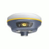
a-GEO NetBOX2 RTK GNSS Receiver
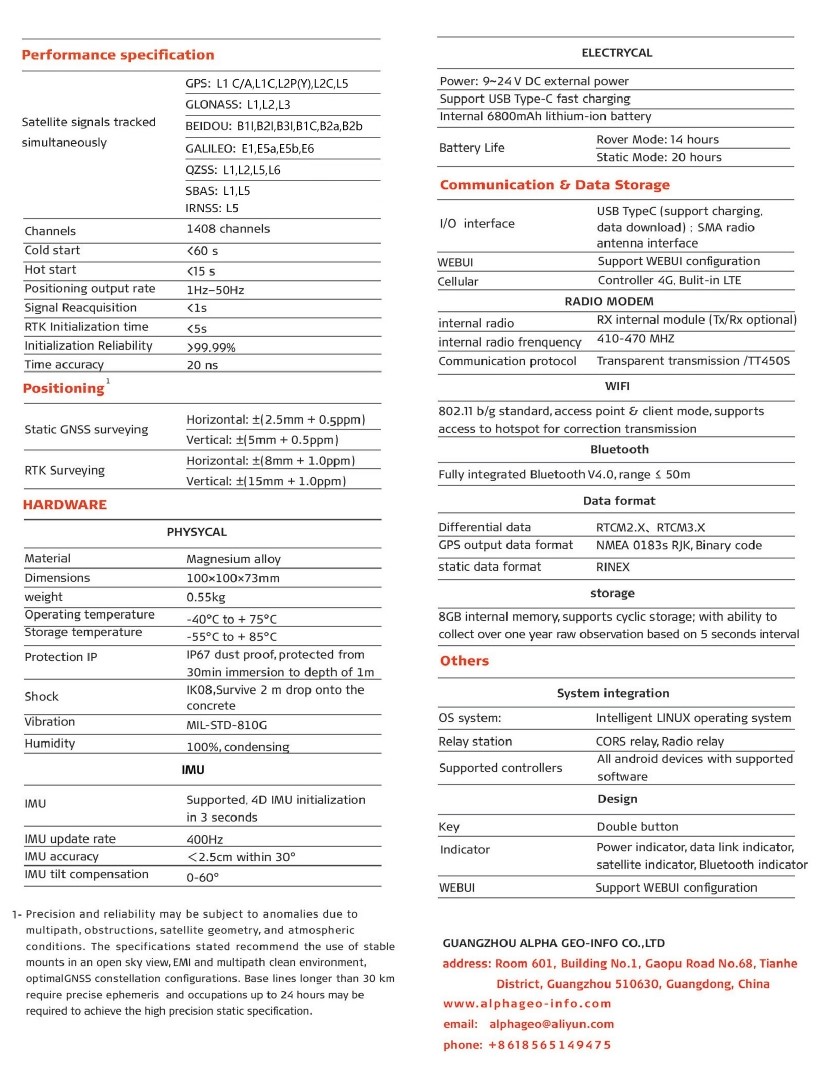
The a-GEO NetBOX2 is a high-performance GNSS receiver for land surveying and construction. Equipped with a 1408-channel chipset supporting GPS, GLONASS, BEIDOU, GALILEO, and more, it delivers exceptional accuracy. The integrated IMU tilt sensor allows efficient data collection at up to 60° angles, eliminating manual leveling. Stay connected with a built-in 4G module and internal UHF radio for real-time data collection. With over 14 hours of battery life and fast USB-C charging, the a-GEO NetBOX2 RTK GNSS Receiver is the ultimate GPS set for construction and land surveying equipment.
| ✅ Channels |
1408 |
| ✅ IMU Tilt Sensor |
60º |
| ✅ Internet Modem |
4G |
| ✅ UHF Radio |
410 – 470MHz |
| GPS |
L1C/A, L1C, L2C, L2P(Y), L5 |
| GLONASS |
L1, L2, L3 |
| GALILEO |
E1, E5a, E5b, E6 |
| BEIDOU |
B1l, B1C, B2l, B2a, B2b, B3l |
Discover the a-GEO NetBOX2 Rover and Base Set: Precision for Land Surveying and Construction
The a-GEO NetBOX2 rover and base set is your ultimate solution for precise land surveying and construction tasks. Designed for professionals who demand accuracy, efficiency, and reliability, this GNSS rover and base set for land surveying sets a new standard in performance.
Why Choose the a-GEO NetBOX2 GNSS Rover and Base Set?
Eliminate Common Struggles in Surveying
Traditional surveying equipment can be time-consuming, prone to errors, and challenging to use in difficult terrains. The a-GEO NetBOX2 GNSS rover and base set addresses these issues with advanced features that streamline your workflow:
- IMU Tilt Compensation: The integrated IMU tilt sensor enables data collection at angles of up to 60°, eliminating the need for manual leveling. This not only saves time but also ensures precision even in challenging conditions.
- Multi-Constellation Support: With a powerful 1408-channel chipset, the NetBOX2 supports GPS, GLONASS, BEIDOU, GALILEO, and more, delivering unmatched accuracy in any environment.
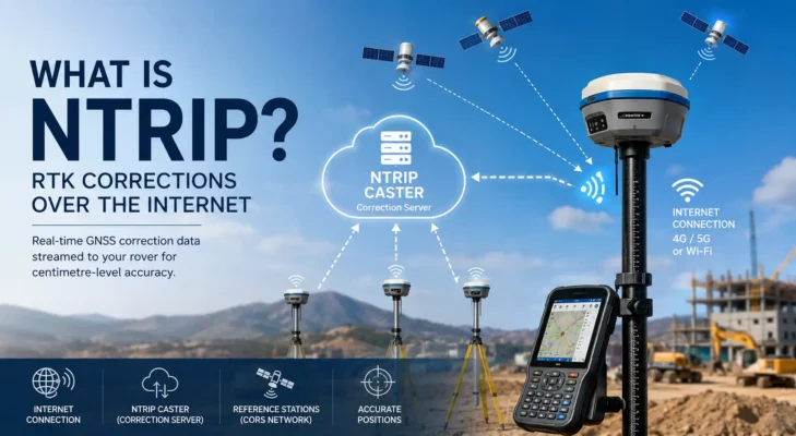
- Seamless Connectivity: Equipped with a built-in 4G module and internal UHF radio, the device ensures real-time data collection and seamless communication between the rover and base station.
- Extended Battery Life: Enjoy over 14 hours of uninterrupted operation, supported by fast USB-C charging to keep you on the go.
Tailored for Construction and Land Surveying
Whether you’re working on a construction site or conducting detailed land surveys, the GNSS set for construction adapts to your needs. Its rugged design and cutting-edge technology make it the ideal GPS set with an IMU tilt sensor for professionals in the field.

Key Features at a Glance
- Advanced GNSS Technology: Leverage the power of multi-constellation tracking for pinpoint accuracy.
- Effortless Data Collection: The IMU tilt compensation feature allows for efficient surveying without the hassle of manual adjustments.
- Long-Lasting Performance: Stay powered throughout your workday with a durable battery and quick charging capabilities.
- Versatile Applications: Perfect for both land surveying and construction, offering the adaptability you need in diverse projects.
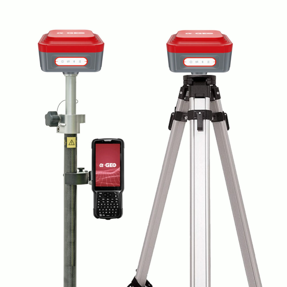
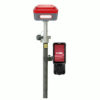
Comprehensive Accessories for Enhanced Versatility
The a-GEO NetBOX2 rover and base set comes complete with all the essential accessories to maximize your efficiency and adaptability in the field:
- a-GEO S50III Data Collector: The a-GEO S50III data collector is a robust and reliable device for managing your survey data.
- SurPro Surveying Software: The SurPro Software is an intuitive software solution that streamlines your workflow and ensures precise results.
- Surveying Pole and Data Collector Bracket: For convenient and stable operation during surveys.
- Tripod, Tribrach, and Adapter: Ensures stability and accuracy for fixed-point measurements.
Customizable Accessories for Your Needs
The a-GEO NetBOX2 rover and base set is flexible to match your specific requirements. Prefer using a tablet instead of the included controller? Or need different software for your workflow? These accessories can be easily modified or upgraded to suit your preferences, ensuring the perfect fit for your projects.


Reviews
There are no reviews yet