
 GPS & GNSS
 Lidar scanning
 Total Station
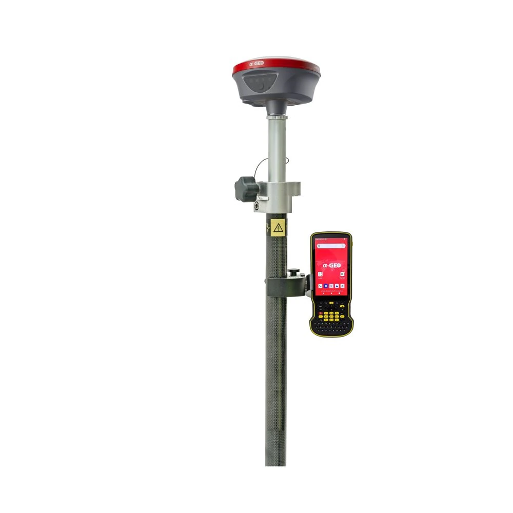


a Geo L100 PRO Plus Rover Set with 120° IMU tilt
This product is available
Get the best price for your setup
Contact our experts for the best possible price and configuration.
The a-Geo L100 PRO+ Rover Set is a complete RTK GNSS field solution for surveyors, construction teams, GIS users and mapping professionals who need reliable centimetre-level positioning without building a complicated setup. The set combines the L100 PRO+ GNSS receiver with the rugged S60III Android data collector, giving you a practical rover package for stakeout, topographic surveys, control points, site measurements and everyday field data collection.
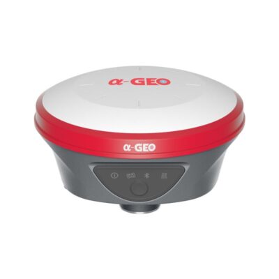
With AR real-scene stakeout, 120° IMU tilt compensation, 1408 tracking channels, 4G connectivity, WiFi/WebUI access and integrated UHF radio, the L100 PRO+ is built for flexible RTK work in both network and local base workflows. The S60III controller adds a physical keyboard, bright display and long battery life for easier work on busy construction sites and outdoor survey projects.
a-Geo L100 PRO+ Rover Set Highlights
| GNSS Channels | 1408 tracking channels |
|---|---|
| Satellite Constellations | GPS, GLONASS, Galileo, BeiDou, QZSS, SBAS and IRNSS |
| Tilt Compensation | Calibration-free IMU tilt up to 120° |
| Stakeout Support | AR real-scene stakeout with integrated camera |
| Connectivity | 4G, WiFi/WebUI, Bluetooth and integrated UHF radio |
| Included Controller | a-Geo S60III rugged Android data collector |

Valued customers:










Find RTK Networks
Search NTRIP providers and connect to reliable RTK correction services.
Description
Complete RTK GNSS rover set for field surveying and mapping
The a-Geo L100 PRO+ Rover Set is made for professionals who need an accurate and practical GNSS rover system for daily fieldwork. It combines the a-Geo L100 PRO+ receiver with the S60III rugged data collector, creating a complete setup for RTK surveying, stakeout, mapping, construction layout, control point measurement and GIS data collection.
This rover set is a strong fit for surveyors, construction workers, engineers, drone mapping teams, GIS technicians and infrastructure crews who want reliable positioning without carrying unnecessary equipment. The receiver supports Network RTK, UHF RTK, static and PPK workflows, so it can be used with an RTK correction network or in a local base and rover setup depending on the project.
AR stakeout for faster point finding
One of the most practical features of the a-Geo L100 PRO+ is AR real-scene stakeout. Instead of relying only on arrows and distances on a map screen, the system can help guide the operator visually toward the target point. This is useful for construction layout, boundary work, utility marking and any job where points need to be found quickly and clearly on site.
For less experienced field crews, AR stakeout can make the workflow easier to understand. For experienced surveyors, it helps reduce time spent walking back and forth to locate the final position of a point.
120° IMU tilt compensation for difficult measurement points
The built-in IMU tilt sensor allows measurements with the pole tilted up to 120°. In real fieldwork, this is useful when a point is close to a wall, fence, tree, trench, vehicle or building corner where holding the pole perfectly vertical is difficult. The IMU is calibration-free and designed to work without being affected by magnetic interference, making it easier to keep working around metal objects and changing site conditions.
Tilt compensation helps speed up topographic surveys, as-built checks and stakeout tasks because the operator does not always need to level the pole exactly before taking a measurement.
Full constellation tracking with 1408 channels
The L100 PRO+ receiver uses a 1408-channel GNSS board and supports major satellite constellations including GPS, GLONASS, Galileo, BeiDou, QZSS, SBAS and IRNSS. More signal availability can help maintain a stable RTK fix in open areas, urban jobsites, road corridors and other environments where satellite visibility changes throughout the day.
For surveyors and mapping teams, this means the receiver is suitable for a wide range of day-to-day tasks such as site control, earthworks checks, road construction, land measurement, asset mapping and drone ground control point collection.
Flexible RTK connectivity
The a-Geo L100 PRO+ includes several communication options for different field workflows. The integrated 4G modem can be used for RTK network corrections through a mobile connection. WiFi and WebUI support make it easier to manage receiver settings, download data and check status from a phone, tablet or computer. The integrated UHF radio also supports local base and rover operation where a correction network is not available or not preferred.
This flexibility is useful for companies that work on different types of projects. A survey crew may use Network RTK in the city one day, UHF RTK on a remote construction site the next day, and static or PPK workflows for control or post-processing when required.
Rugged receiver built for outdoor work
The receiver has a magnesium alloy body, IP67 protection and a 7000 mAh internal lithium-ion battery. It is designed for long workdays in outdoor environments where dust, moisture, transport and regular handling are part of the job. USB Type-C fast charging also keeps charging simple and practical for modern field kits.
The compact receiver design makes it easy to use on a survey pole, while the battery capacity supports long sessions in the field for rover, base and static use.
S60III rugged data collector included
The included a-Geo S60III data collector gives the rover set a durable field controller for measurement and mapping work. It runs Android 12 with GMS support and uses a Qualcomm SDM 662 octa-core processor, 4 GB RAM and 64 GB internal storage. The 5.5 inch full HD display is designed for outdoor readability, while the physical QWERTY keyboard helps with fast point coding and data entry in wet, dusty or cold conditions.
The S60III also includes Bluetooth 5.0, dual-band WiFi, 4G modem support, USB Type-C, NFC and a 9000 mAh battery. With IP68 protection and a rugged handheld design, it is built for construction sites, survey work, GIS mapping and other outdoor data collection tasks where a normal smartphone or tablet may not be practical.
Made for survey, construction, GIS and drone mapping workflows
The a-Geo L100 PRO+ Rover Set is suitable for professionals who need accurate GNSS positioning in the field. Surveyors can use it for topographic surveys, control points, boundary work and stakeout. Construction teams can use it for layout, checking levels, recording as-built positions and measuring site progress. GIS users can collect accurate asset locations for utilities, infrastructure, land management and environmental projects. Drone pilots can use it to measure ground control points and checkpoints for photogrammetry or LiDAR workflows.
Because the set includes both the GNSS receiver and rugged controller, it gives teams a complete rover solution that can be deployed quickly. It is a practical choice for buyers who want modern GNSS features such as AR stakeout, IMU tilt, full constellation tracking and multiple correction options in one package.
Why buy the a-Geo L100 PRO+ Rover Set from Global GPS Systems
Global GPS Systems supplies GNSS equipment to surveyors, construction professionals, engineers, GIS users and mapping teams worldwide. When choosing a rover set, support and product knowledge are just as important as the specifications. Global GPS Systems can help you compare GNSS receivers, understand RTK correction options and choose the right setup for your field workflow.
The a-Geo L100 PRO+ Rover Set is a strong option for professionals who want a complete RTK GNSS rover package with modern positioning features, rugged field hardware and flexible connectivity for different jobsite conditions.
Datasheets & Manuals
Datasheets and manuals
Datasheets
Specifications
a-Geo L100 PRO+ Rover Set Specifications
Product Overview
| Product Name | a-Geo L100 PRO+ Rover Set |
|---|---|
| Product Type | RTK GNSS rover set |
| Receiver | a-Geo L100 PRO+ smart GNSS receiver |
| Data Collector | a-GEO S60III rugged data collector |
| Field Software Support | SurPro6.0 field software workflow support |
| Typical Applications | RTK surveying, construction layout, topographic surveying, GIS data collection, road and infrastructure work, CAD-based stakeout, static surveying and PPK workflows |
| Supported Working Modes | Network RTK, UHF RTK, Static and PPK |
GNSS Performance
| GNSS Channels | 1408 tracking channels |
|---|---|
| Satellite Constellations | GPS, GLONASS, BeiDou, Galileo, QZSS, SBAS and IRNSS |
| GPS Signals | L1C/A, L1C, L2P(Y), L2C, L5 |
| GLONASS Signals | L1, L2, L3 |
| BeiDou Signals | B1I, B2I, B3I, B1C, B2a, B2b |
| Galileo Signals | E1, E5a, E5b, E6 |
| QZSS Signals | L1, L2, L5, L6 |
| SBAS Signals | L1, L5 |
| IRNSS Signals | L5 |
| Cold Start | < 60 seconds |
| Hot Start | < 15 seconds |
| Signal Reacquisition | < 1 second |
| Positioning Output Rate | 1 Hz to 20 Hz |
| RTK Initialization Time | < 10 seconds |
| Initialization Reliability | > 99.99% |
| Time Accuracy | 20 ns |
Positioning Accuracy
| Code Differential GNSS Accuracy | Horizontal: 0.25 m + 1 ppm RMS; Vertical: 0.50 m + 1 ppm RMS |
|---|---|
| SBAS Differential Positioning | Typically < 5 m 3DRMS |
| Static GNSS Surveying Accuracy | Horizontal: 2.5 mm + 0.5 ppm RMS; Vertical: 5 mm + 0.5 ppm RMS |
| Single Baseline RTK Range | Baseline < 30 km |
| Single Baseline RTK Accuracy | Horizontal: 8 mm + 1 ppm RMS; Vertical: 15 mm + 1 ppm RMS |
| Network RTK Accuracy | Horizontal: 8 mm + 0.5 ppm RMS; Vertical: 15 mm + 0.5 ppm RMS |
IMU, Camera and Stakeout Features
| Tilt Compensation | Calibration-free IMU tilt compensation up to 120° |
|---|---|
| IMU Interference Resistance | Designed to be immune to magnetic interference |
| AR Stakeout | Real-scene AR stakeout supported |
| Receiver Camera | 5 MP high-definition camera |
| Camera Function | Live-scene stakeout and visual point navigation |
Receiver Communications and Data
| Cellular Modem | Integrated full-frequency multi-band 4G modem |
|---|---|
| Cellular Network Support | WCDMA, CDMA2000, TDD-LTE and FDD-LTE |
| SIM Card Slot | Nano-SIM support |
| UHF Radio | Integrated Tx/Rx internal UHF radio |
| UHF Frequency Band | 410 MHz to 470 MHz, selectable frequency |
| Radio Transmit Power | 1 W / 2 W switchable |
| UHF Working Range | Up to 15 km under AlphaTalk15 protocol |
| Radio Protocols | AlphaTalk15, TrimTalk450s, SOUTH, Satel, PCC-EOT |
| WiFi | 802.11 b/g/n, access point and client mode |
| WiFi Functions | WebUI access, receiver management, hotspot access and correction transmission support |
| Bluetooth | Bluetooth 5.2 |
| Bluetooth Range | < 50 m |
| LEMO Port | 5-pin port supporting power input, serial port control and external radio communication |
| USB Port | USB Type-C for charging |
| Antenna Port | UHF antenna interface |
| Data Formats | RTCM2x, RTCM3x, CMR, CMR+, SCMRx, DAT, RINEX and NMEA outputs |
| Internal Storage | 8 GB internal memory with cyclic storage support |
Receiver Hardware and Durability
| Receiver Material | Magnesium alloy |
|---|---|
| Receiver Dimensions | 131 × 64 mm |
| Receiver Weight | 0.76 kg |
| Operating Temperature | -40°C to +75°C |
| Storage Temperature | -55°C to +85°C |
| Protection Rating | IP67 dustproof and protected from 30 minutes immersion to 1 m depth |
| Shock Resistance | Survives 2 m drop onto concrete |
| Vibration | MIL-STD-810G |
| Humidity | 100%, condensing |
| Receiver Button | Power key |
| Receiver Indicators | Power indicator, data link indicator, satellite indicator and Bluetooth indicator |
| Voice Prompts | Intelligent voice prompts |
| Receiver Operating System | Intelligent Linux operating system |
| WebUI | WebUI configuration supported |
| Supported Controllers | Android devices with supported software |
Receiver Power
| External Power Input | 9 V to 24 V DC |
|---|---|
| Charging Port | USB Type-C |
| Fast Charging | Supported |
| Internal Battery | 7000 mAh lithium-ion battery |
| Battery Life – Rover Mode | More than 15 hours |
| Battery Life – Base Mode | 7 hours |
| Battery Life – Static Mode | 17 hours |
S60III Data Collector System
| Operating System | Android 12 with GMS support |
|---|---|
| Processor | Qualcomm SDM 662 octa-core 2.0 GHz |
| RAM | 4 GB SDRAM |
| Internal Storage | 64 GB flash memory |
| Memory Card Support | MicroSDHC up to 128 GB |
| Display | 5.5-inch IPS LTPS LCD capacitive multi-touch display |
| Display Resolution | 1920 × 1080 pixels, HD+, 401 ppi |
| Display Brightness | 500 nits |
| Display Glass | Gorilla Glass / Corning glass screen |
| Keyboard | QWERTY key layout with physical keypad and shortcut buttons |
S60III Data Collector Physical and Environmental
| Dimensions | 228 mm × 96 mm × 21 mm |
|---|---|
| Weight | 420 g with battery |
| Operating Temperature | -20°C to +65°C |
| Storage Temperature | -30°C to +70°C |
| Dust and Water Protection | IP68 |
| Humidity | 5% to 95%, non-condensing |
| Shock and Vibration | 1.2 m fall on concrete |
S60III Data Collector Communications
| SIM Card Type | Nano-SIM card |
|---|---|
| GSM Bands | 850 / 900 / 1800 / 1900 |
| WCDMA Bands | B1 / B2 / B4 / B5 / B8 |
| LTE-TDD Bands | B34 / B38 / B39 / B40 / B41 |
| LTE-FDD Bands | B1 / B2 / B3 / B4 / B5 / B7 / B8 / B12 / B13 / B17 / B20 / B25 / B26 / B28 |
| WiFi | 802.11 a/b/g/n/ac |
| WiFi Mode | Access point mode, 2.4 GHz / 5 GHz |
| Bluetooth | Bluetooth 5.0 |
| USB | USB Type-C, OTG supported |
| NFC | Supported |
S60III Data Collector Power, Sensors and Multimedia
| Battery Type | Li-ion battery |
|---|---|
| Battery Capacity | 9000 mAh |
| Operating Time | Up to 22 hours |
| Charging Time | Approximately 4 hours typical |
| Rear Camera | 13 MP rear camera with autofocus and flash |
| Internal GNSS | BDS, GPS and GLONASS with A-GPS support |
| Sensors | G-sensor, gyroscope, e-compass and light sensor |
| Audio | Speaker and microphone |
| Certifications | CE and FCC |
SurPro6.0 Field Software Functions
| Project Tools | Project management, coordinate system parameters, conversion settings, point library, code library and survey area settings |
|---|---|
| Instrument Tools | Communication settings, rover mode, reference station mode, static mode, instrument information, satellite sky map and positioning information |
| Survey Tools | Point survey, detail survey, control point measurement, point stakeout, CAD, line stakeout, DSM stakeout, road design stakeout and GIS data collection |
| CAD Tools | CAD graphic display, lines, polylines, arcs, polygons, layer management, DXF/DWG import, DXF export and CAD graphic stakeout |
| Calculation Tools | Coordinate conversion, angle conversion, perimeter and area calculation, calculator and CAD-related calculation tools |
| Road Tools | Road design stakeout, line stakeout, cross-section stakeout and cross-section measurement workflows |
Package / Included Items
| Item | Quantity | Notes |
|---|---|---|
| a-Geo L100 PRO+ GNSS receiver | 1 | Main RTK GNSS rover receiver |
| a-GEO S60III data collector | 1 | Rugged Android field controller |
| SurPro6.0 field software workflow support | 1 | For measurement, stakeout, CAD, road and GIS workflows |
| S60III A/C charger | 1 | Standard S60III accessory |
| S60III USB cable | 1 | Standard S60III accessory |
| S60III stylus | 1 | Standard S60III accessory |
| S60III handstrap | 1 | Standard S60III accessory |
Specifications and package contents may vary by configuration, region or manufacturer update. Always check the current configuration before ordering.
FAQ
a-Geo L100 PRO+ Rover Set FAQ
Product Overview and Applications
What is the a-Geo L100 PRO+ Rover Set used for?
The a-Geo L100 PRO+ Rover Set is used for RTK surveying, construction layout, topographic mapping, GIS data collection, road and infrastructure projects, as-built measurements, static surveying and PPK workflows.
Who is the a-Geo L100 PRO+ Rover Set designed for?
This rover set is designed for surveyors, construction professionals, civil engineers, GIS teams, mapping crews, infrastructure contractors and field users who need accurate GNSS positioning in daily outdoor work.
What is included in the a-Geo L100 PRO+ Rover Set?
The set combines the a-Geo L100 PRO+ smart GNSS receiver with the rugged S60III data collector and SurPro6.0 field software workflow support, creating a practical complete rover package for field measurement and stakeout tasks.
Is this a complete RTK rover package?
Yes. The rover set is intended as a complete field solution for users who need a GNSS receiver, controller and field software workflow for RTK point collection, stakeout, CAD-based work and correction service connection.
Can this rover set be used for construction layout?
Yes. The a-Geo L100 PRO+ Rover Set is suitable for construction layout and stakeout, including point stakeout, line stakeout, CAD graphic stakeout and road-related field workflows.
Can it be used for GIS and mapping work?
Yes. The system can be used for GIS data collection, mapping, topographic surveys, field point collection and site documentation where accurate GNSS positioning is required.
Accuracy, GNSS and RTK Performance
What RTK accuracy does the a-Geo L100 PRO+ provide?
The receiver is specified with single-baseline RTK accuracy of 8 mm + 1 ppm horizontal and 15 mm + 1 ppm vertical. For network RTK, it is specified at 8 mm + 0.5 ppm horizontal and 15 mm + 0.5 ppm vertical.
How many GNSS channels does the receiver have?
The a-Geo L100 PRO+ has 1408 GNSS tracking channels, helping it track multiple satellite signals for reliable positioning in professional field applications.
Which satellite constellations does it support?
The receiver supports GPS, GLONASS, BeiDou, Galileo, QZSS, SBAS and IRNSS signals, making it suitable for use across many regions and GNSS correction environments.
How fast does the receiver initialize RTK?
The a-Geo L100 PRO+ is specified with an RTK initialization time of less than 10 seconds and initialization reliability greater than 99.99% under suitable field and correction conditions.
Can the receiver be used for static surveying and PPK?
Yes. The receiver supports static GNSS surveying and PPK workflows. It also includes internal storage and data formats suitable for raw data collection and post-processing workflows.
What correction methods can this rover use?
The rover can work with network RTK corrections through its integrated 4G modem and can also be used in UHF RTK base/rover workflows with its integrated UHF radio.
IMU Tilt, AR Stakeout and Field Workflow
Does the a-Geo L100 PRO+ support tilt measurement?
Yes. The receiver supports calibration-free IMU tilt compensation up to 120°, allowing users to measure or stake points when the pole cannot be held perfectly vertical.
When is IMU tilt compensation useful?
IMU tilt compensation is useful near walls, fences, corners, slopes, parked vehicles, road edges, trenches and other obstacles where it is difficult or unsafe to position the pole directly above the target point.
Does the receiver support AR real-scene stakeout?
Yes. The a-Geo L100 PRO+ includes a 5 MP camera for AR real-scene stakeout, helping users navigate to stakeout points using a live field view instead of relying only on a map screen.
How does AR stakeout help in the field?
AR stakeout helps users find points more intuitively by showing guidance in the real-world camera view. This can make layout work faster and easier on busy construction sites or large survey areas.
Can I use CAD files in the field?
Yes. SurPro6.0 supports CAD functions including DXF and DWG import, DXF export, layer management, CAD drawing tools, CAD calculations and CAD graphic stakeout.
Does the software support road stakeout?
Yes. SurPro6.0 includes road design stakeout, line stakeout, cross-section stakeout and cross-section measurement workflows for road and infrastructure projects.
Can I manage coordinate systems and localization in the software?
Yes. SurPro6.0 supports project configuration, coordinate system settings, coordinate conversion parameters, localization using control points, point libraries and code libraries.
Hardware, Connectivity and Durability
How rugged is the a-Geo L100 PRO+ receiver?
The receiver has a magnesium alloy body, IP67 protection, 2 metre drop resistance onto concrete, MIL-STD-810G vibration rating and an operating temperature range from -40°C to +75°C.
How long does the receiver battery last?
The internal 7000 mAh lithium-ion battery is specified for more than 15 hours in rover mode, 7 hours in base mode and 17 hours in static mode. USB Type-C fast charging is supported.
What connectivity options does the receiver have?
The receiver includes integrated 4G, UHF radio, WiFi, Bluetooth 5.2, WebUI support, a nano-SIM slot, USB Type-C and a 5-pin LEMO port for power input, serial control and external radio communication.
What is the UHF radio range?
The integrated UHF radio works in the 410 MHz to 470 MHz frequency band and is specified with a working range of up to 15 km under AlphaTalk15 protocol in suitable conditions.
What data formats does the receiver support?
The receiver supports RTCM2x, RTCM3x, CMR, CMR+, SCMRx, DAT, RINEX and NMEA outputs, making it suitable for common RTK, raw data and post-processing workflows.
What are the main features of the S60III data collector?
The S60III data collector has a 5.5-inch Gorilla Glass display, Qualcomm processor, Bluetooth 5.0, dual-band WiFi, global 4G modem, 9000 mAh battery and IP68 protection for demanding field use.
Additional information
| GNSS feature | GNSS with Camera, GNSS with IMU |
|---|
Reviews (0)
Only logged in customers who have purchased this product may leave a review.
 GPS & GNSS
 Total Stations
 Data collectors
 Software
 Correction services
 Machine control
 External radio
 Lasers & levellers
 Marine
 Accessories
Reviews
There are no reviews yet