
 GPS & GNSS
 Lidar scanning
 Total Station

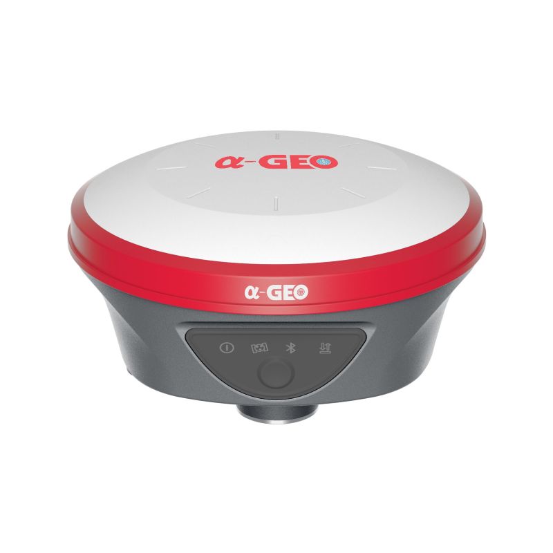


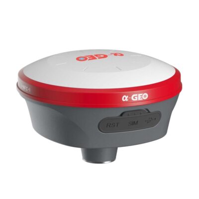
a Geo L100 PRO Plus RTK GNSS Receiver with AR and IMU Tilt
This product is Available
Contact our experts for the best possible price and configuration.
The a-Geo L100 PRO+ is a compact RTK GNSS receiver for surveyors, construction teams, GIS users, engineers and drone mapping professionals who need accurate positioning in daily fieldwork. With AR real-scene stakeout, 120° IMU tilt compensation, 1408 GNSS channels, 4G, WiFi/WebUI and an integrated UHF radio, it is built for topo surveys, construction layout, control points, as-built checks and mapping work.
a-Geo L100 PRO+ Highlights
| GNSS Channels | 1408 tracking channels |
|---|---|
| Satellite Constellations | GPS, GLONASS, BeiDou, Galileo, QZSS, SBAS and IRNSS |
| AR Stakeout | Real-scene stakeout with integrated 5 MP camera |
| IMU Tilt Compensation | Calibration-free IMU tilt up to 120° |
| Connectivity | 4G modem, UHF radio, WiFi, WebUI and Bluetooth 5.2 |
| RTK Work Modes | Network RTK, UHF RTK, Static and PPK |
| Battery | 7000 mAh internal battery with USB Type-C fast charging |


Valued customers:










Find RTK Networks
Search NTRIP providers and connect to reliable RTK correction services.
Description
a-Geo L100 PRO+ RTK GNSS receiver for practical field surveying
The a-Geo L100 PRO+ is a compact smart RTK GNSS receiver designed for accurate positioning in real field conditions. It is made for professionals who need a reliable rover for measuring points, staking out designs, collecting site data and working with different correction methods without making the setup more complicated than necessary.
This receiver is a good fit for land surveyors, construction workers, civil engineers, GIS teams, infrastructure contractors and drone pilots. It can be used for topographic surveys, construction layout, road and utility work, as-built checks, ground control points, boundary support work, site verification and general RTK measurement tasks.
AR real-scene stakeout for easier layout work
The a-Geo L100 PRO+ includes AR real-scene stakeout, supported by an integrated 5 MP camera. In practice, this helps operators move towards the correct point by following visual guidance on the controller screen. Instead of repeatedly moving the pole back and forth while checking directions, the user can see the stakeout location in a more intuitive way.
This is useful for construction layout, road marking, utility points, site set-out and other tasks where crews need to find design points quickly and clearly. For less experienced users, AR stakeout can also make GNSS layout work easier to understand because the guidance is shown in relation to the real site environment.
120° IMU tilt compensation for faster measurements
The integrated IMU tilt sensor allows measurements and stakeout work when the pole cannot be held perfectly vertical. The a-Geo L100 PRO+ supports calibration-free tilt compensation up to 120°, helping crews collect points near walls, fences, trenches, stockpiles, road edges, machinery and other obstacles.
For surveyors, this can reduce time spent carefully levelling the pole on every point. For construction workers and site engineers, it makes everyday measurements more practical, especially in areas where standing directly above the point is difficult or unsafe.
Multi-constellation GNSS tracking for stable positioning
The a-Geo L100 PRO+ uses a 1408-channel GNSS board and supports GPS, GLONASS, BeiDou, Galileo, QZSS, SBAS and IRNSS. More available satellite signals can help the receiver maintain stronger positioning performance on busy jobsites, near buildings, around trees or in other locations where sky visibility is not ideal.
For field crews, this means less waiting and a better chance of keeping work moving when site conditions are not perfect. The receiver is designed for centimetre-level RTK workflows when used with suitable correction data and correct field procedures.
Flexible RTK, Static and PPK workflows
The a-Geo L100 PRO+ supports Network RTK, UHF RTK, Static and PPK working modes. This gives users flexibility to choose the method that matches the jobsite, available corrections and project requirements.
Network RTK is useful when an NTRIP correction service is available through mobile internet. UHF RTK is useful for local base and rover work, especially on sites where mobile coverage is unreliable. Static and PPK workflows are useful when post-processing is required, or when the project needs raw GNSS observation data for later office processing.
Built-in 4G, UHF radio, WiFi and WebUI
The receiver includes a built-in full-frequency multi-band 4G modem for receiving correction data through mobile networks. It also has an integrated UHF radio operating in the 410 to 470 MHz range, with selectable frequency support for base and rover workflows.
WiFi and WebUI access make it easier to manage the receiver from a phone, tablet or computer. Users can check device status, adjust settings and download raw data without needing a separate cable for every task. Bluetooth 5.2 is also included for connection with compatible controllers and field software.
Rugged design for daily site conditions
The a-Geo L100 PRO+ has a magnesium alloy body and IP67 protection. It is designed for outdoor fieldwork where dust, rain, wet ground and rough handling are part of the job. Its compact size and 0.76 kg weight make it comfortable for rover use during long survey days.
The internal 7000 mAh lithium-ion battery supports long field sessions, with USB Type-C fast charging for practical daily use. This makes the receiver suitable for crews who need a dependable RTK rover for a full working day without carrying unnecessary equipment.
Who uses the a-Geo L100 PRO+
The a-Geo L100 PRO+ is suitable for users who need accurate GNSS positioning but still want a straightforward field setup. Surveyors can use it for topo surveys, stakeout, control checks and post-processing workflows. Construction teams can use it for layout, site checks, road work and as-built measurements. GIS users can collect accurate asset and feature locations. Drone pilots can measure ground control points and check points for mapping projects.
It is also a practical option for companies comparing RTK GNSS receivers with AR stakeout, IMU tilt and integrated communication options in one compact unit.
Why buy the a-Geo L100 PRO+ from Global GPS Systems?
Global GPS Systems supplies GNSS equipment to surveyors, construction companies, engineers, GIS teams and mapping professionals worldwide. When you buy the a-Geo L100 PRO+ from Global GPS Systems, you get access to product specialists who understand RTK workflows, correction services, controller compatibility and practical field requirements.
This support is useful when selecting the right receiver configuration, setting up RTK corrections, choosing accessories or comparing the a-Geo L100 PRO+ with other GNSS receivers for your work.
Datasheets & Manuals
Datasheets and manuals
Datasheet
Specifications
a-Geo L100 PRO+ Specifications
Product Overview
| Product Name | a-Geo L100 PRO+ |
|---|---|
| Product Type | Compact smart RTK GNSS receiver |
| Primary Use | Professional surveying, construction layout, mapping, stakeout, base/rover RTK, Network RTK, Static and PPK workflows |
| Main Technologies | Full GNSS tracking, AR real-scene stakeout, calibration-free IMU tilt compensation, integrated UHF radio, 4G modem, WiFi/WebUI and Bluetooth |
| Working Modes | Static, Network RTK, UHF RTK, PPK, Base and Rover operation |
GNSS Performance
| Tracking Channels | 1408 channels |
|---|---|
| Satellite Signals Tracked | GPS, GLONASS, BeiDou, Galileo, QZSS, SBAS and IRNSS |
| GPS Signals | L1C/A, L1C, L2P(Y), L2C, L5 |
| GLONASS Signals | L1, L2, L3 |
| BeiDou Signals | B1I, B2I, B3I, B1C, B2a, B2b |
| Galileo Signals | E1, E5a, E5b, E6 |
| QZSS Signals | L1, L2, L5, L6 |
| SBAS Signals | L1, L5 |
| IRNSS Signals | L5 |
| Cold Start | < 50 s |
| Hot Start | < 15 s |
| Positioning Output Rate | 1 Hz to 20 Hz |
| Signal Reacquisition | < 1 s |
| RTK Initialization Time | < 10 s |
| Initialization Reliability | > 99.99% |
| Time Accuracy | 20 ns |
Positioning Accuracy
| Mode | Horizontal Accuracy | Vertical Accuracy |
|---|---|---|
| Code Differential GNSS | 0.25 m + 1 ppm RMS | 0.50 m + 1 ppm RMS |
| SBAS Differential Positioning | Typically < 5 m 3DRMS | |
| Static GNSS Surveying | 2.5 mm + 0.5 ppm RMS | 5 mm + 0.5 ppm RMS |
| Single Baseline RTK < 30 km | 8 mm + 1 ppm RMS | 15 mm + 1 ppm RMS |
| Network RTK | 8 mm + 0.5 ppm RMS | 15 mm + 0.5 ppm RMS |
AR Stakeout and IMU Tilt
| AR Real-Scene Stakeout | Supported |
|---|---|
| Camera | 5 MP high-definition camera with wide viewing angle for live-scene stakeout |
| IMU Tilt Compensation | Supported |
| Maximum Tilt Angle | Up to 120° |
| IMU Calibration | Calibration-free |
| Magnetic Interference Resistance | IMU described as immune to magnetic interference |
Radio and Cellular Communication
| Integrated UHF Radio | Tx/Rx internal UHF radio |
|---|---|
| UHF Frequency Band | 410 MHz to 470 MHz, selectable frequency |
| UHF Transmit Power | 1 W / 2 W switchable |
| UHF Working Range | Up to 15 km under AlphaTalk15 protocol |
| Radio Protocols | AlphaTalk15, TrimTalk450s, SOUTH, Satel, PCC-EOT |
| Cellular Modem | Integrated full-frequency multi-band 4G modem |
| Cellular Network Support | WCDMA, CDMA2000, TDD-LTE and FDD-LTE |
| SIM Card | Nano-SIM supported |
WiFi, Bluetooth and WebUI
| WiFi | 802.11 b/g standard |
|---|---|
| WiFi Modes | Access point and client mode |
| Correction Transmission via Hotspot | Supported |
| Bluetooth | Fully integrated Bluetooth V5.2 |
| Bluetooth Range | Up to 50 m |
| WebUI | Supported for receiver configuration, status management and data download |
Ports and Interfaces
| LEMO Port | 5-pin LEMO port supporting power input, serial port control and external radio communication |
|---|---|
| USB Port | USB Type-C port |
| USB Type-C Functions | Charging and data communication |
| SIM Slot | Nano-SIM card slot |
| Antenna Port | UHF antenna interface |
| Reset Button | Supported |
Data, Storage and Formats
| Internal Storage | 8 GB internal memory |
|---|---|
| Cyclic Storage | Supported |
| Raw Observation Capacity | Over one year of raw observation storage based on 5-second interval |
| Data Formats | RTCM2x, RTCM3x, CMR, CMR+, sCMRx, DAT, RINEX and NMEA outputs |
| Static Data Download | Supported through WebUI |
| PPK Raw Data Download | Supported through WebUI |
Power and Battery
| External Power Input | 9 V to 24 V DC |
|---|---|
| Fast Charging | USB Type-C fast charging supported |
| Battery Type | Internal lithium-ion battery |
| Battery Capacity | 7000 mAh |
| Rover Mode Battery Life | 15 hours |
| Base Mode Battery Life | 7 hours |
| Static Mode Battery Life | 17 hours |
Physical Specifications
| Body Material | Magnesium alloy |
|---|---|
| Dimensions | 131 x 64 mm |
| Weight | 0.76 kg |
| Button | Power key |
| Indicators | Power indicator, data link indicator, satellite indicator and Bluetooth indicator |
| Voice Prompts | Intelligent voice prompts |
Environmental and Durability
| Operating Temperature | -40°C to +75°C |
|---|---|
| Storage Temperature | -55°C to +85°C |
| Ingress Protection | IP67 dustproof, protected from 30-minute immersion to a depth of 1 m |
| Shock Resistance | Survives 2 m drop onto concrete |
| Vibration | MIL-STD-810G |
| Humidity | 100%, condensing |
System and Controller Compatibility
| Operating System | Intelligent Linux operating system |
|---|---|
| Supported Controllers | All Android devices with supported software |
| NTRIP Support | NTRIP client/server workflows supported through network configuration |
| Base Configuration | Can be configured as a base using internal UHF, network or NTRIP caster workflows |
| Rover Configuration | Can operate as rover receiving corrections through built-in radio or built-in network |
Specifications and package contents may vary by configuration, region or manufacturer update. Always check the current configuration before ordering.
FAQ
a-Geo L100 PRO+ FAQ
Product Overview
What is the a-Geo L100 PRO+?
The a-Geo L100 PRO+ is a compact professional RTK GNSS receiver designed for accurate field surveying, stakeout, mapping, static measurement, PPK workflows, and RTK positioning. It combines multi-constellation GNSS tracking, IMU tilt measurement, AR real-scene stakeout, 4G connectivity, UHF radio, WiFi, WebUI access, and a rugged IP67 housing.
Who is the a-Geo L100 PRO+ designed for?
The receiver is designed for professional surveyors, construction layout teams, infrastructure contractors, utility mapping crews, geospatial professionals, agriculture users, forestry users, and field teams that need reliable centimetre-level GNSS positioning.
What types of surveying work can it be used for?
The a-Geo L100 PRO+ can be used for Network RTK, UHF RTK, static surveying, PPK surveying, point collection, topographic surveys, construction stakeout, utility location, mapping, and base/rover field workflows.
Is the a-Geo L100 PRO+ suitable for professional land surveying?
Yes. The receiver is built for professional surveying tasks and includes key field features such as RTK support, multi-frequency GNSS tracking, IMU tilt compensation, AR stakeout, 4G correction access, UHF radio, and rugged outdoor protection.
Can the a-Geo L100 PRO+ be used as both a rover and a base?
Yes. The receiver supports flexible working modes, including Network RTK, UHF RTK, Static, and PPK. It can be used in rover workflows and can also support base/rover operation when configured with the correct setup and accessories.
What makes the a-Geo L100 PRO+ different from a basic GPS receiver?
Unlike basic GPS receivers, the a-Geo L100 PRO+ is a professional GNSS receiver with RTK capability, 1408 tracking channels, support for multiple satellite constellations, IMU tilt measurement, AR stakeout, 4G connectivity, UHF radio, and centimetre-level positioning when used with suitable correction data.
Accuracy, GNSS and Survey Modes
What accuracy can the a-Geo L100 PRO+ achieve?
With RTK corrections, the a-Geo L100 PRO+ is designed for centimetre-level positioning. The datasheet lists Network RTK accuracy of 8 mm + 0.5 ppm RMS horizontally and 15 mm + 0.5 ppm RMS vertically under suitable conditions.
Does the a-Geo L100 PRO+ support RTK?
Yes. The receiver supports RTK surveying through Network RTK and UHF RTK workflows. This allows the receiver to use correction data for high-accuracy real-time positioning in the field.
Does the a-Geo L100 PRO+ support PPK?
Yes. The receiver supports PPK workflows, allowing survey data to be processed after field collection when real-time corrections are not available or when post-processing is preferred.
Does the receiver support static surveying?
Yes. The a-Geo L100 PRO+ supports static GNSS surveying. Static mode is useful for control points, reference measurements, and projects where post-processed high-accuracy positioning is required.
Which satellite constellations does the a-Geo L100 PRO+ support?
The a-Geo L100 PRO+ supports major GNSS constellations, including GPS, GLONASS, Galileo, BeiDou, QZSS, SBAS, and IRNSS. This helps improve satellite availability and positioning reliability in different regions and field conditions.
How many GNSS channels does the a-Geo L100 PRO+ have?
The receiver has 1408 GNSS tracking channels. This allows it to track many satellite signals across multiple constellations and frequencies for reliable professional positioning.
Field Features and Connectivity
What is AR real-scene stakeout?
AR real-scene stakeout uses a live camera view and on-screen guidance to help the user find stakeout points in the field. It can make stakeout work more intuitive by showing directional guidance in the real environment.
How does the IMU tilt sensor help during surveying?
The IMU tilt sensor allows users to measure or stake out points while the survey pole is tilted. This is useful when points are difficult to reach, such as near walls, fences, obstacles, traffic, trenches, or building corners.
What tilt angle does the IMU support?
The a-Geo L100 PRO+ supports IMU tilt measurement up to 120 degrees, helping users collect or stake out points without always needing to keep the pole perfectly vertical.
Does the IMU need calibration?
The receiver is described as having a calibration-free IMU tilt sensor. This helps reduce setup time and keeps field workflows faster and more efficient.
Does the a-Geo L100 PRO+ have a built-in 4G modem?
Yes. The receiver includes an integrated 4G modem for receiving correction data through mobile internet, including Network RTK workflows where a compatible correction service is available.
Does the a-Geo L100 PRO+ include UHF radio?
Yes. The receiver includes an integrated UHF radio operating in the 410 MHz to 470 MHz frequency range. This supports base/rover workflows where UHF correction transmission is required.
Power, Durability and Data
How long does the battery last?
The a-Geo L100 PRO+ has a 7000 mAh internal lithium-ion battery. The product information lists more than 12 hours of continuous fieldwork, with the datasheet listing rover mode battery life of up to 15 hours, base mode up to 7 hours, and static mode up to 17 hours.
How is the a-Geo L100 PRO+ charged?
The receiver supports USB Type-C fast charging, making it convenient to recharge using modern charging equipment suitable for field and office use.
Is the a-Geo L100 PRO+ waterproof and dustproof?
Yes. The receiver has an IP67 rating, meaning it is designed for protection against dust and water exposure in demanding outdoor field conditions.
What is the receiver housing made from?
The a-Geo L100 PRO+ uses a magnesium alloy body, giving it a rugged yet lightweight construction for professional outdoor surveying work.
Can I manage the receiver without cables?
Yes. The receiver supports WiFi and WebUI access, allowing users to manage settings, monitor device status, and download data from a smartphone, tablet, or computer without needing extra cables or third-party software for basic receiver management.
Which data formats does the a-Geo L100 PRO+ support?
The receiver supports common professional GNSS data formats, including RTCM, CMR, CMR+, sCMRx, raw data, RINEX, and NMEA outputs. This helps it fit into different surveying and post-processing workflows.
Reviews (0)
Only logged in customers who have purchased this product may leave a review.


 GPS & GNSS
 Total Stations
 Data collectors
 Software
 Correction services
 Machine control
 External radio
 Lasers & levellers
 Marine
 Accessories
Reviews
There are no reviews yet