

 GPS & GNSS
 Lidar scanning
 Total Station
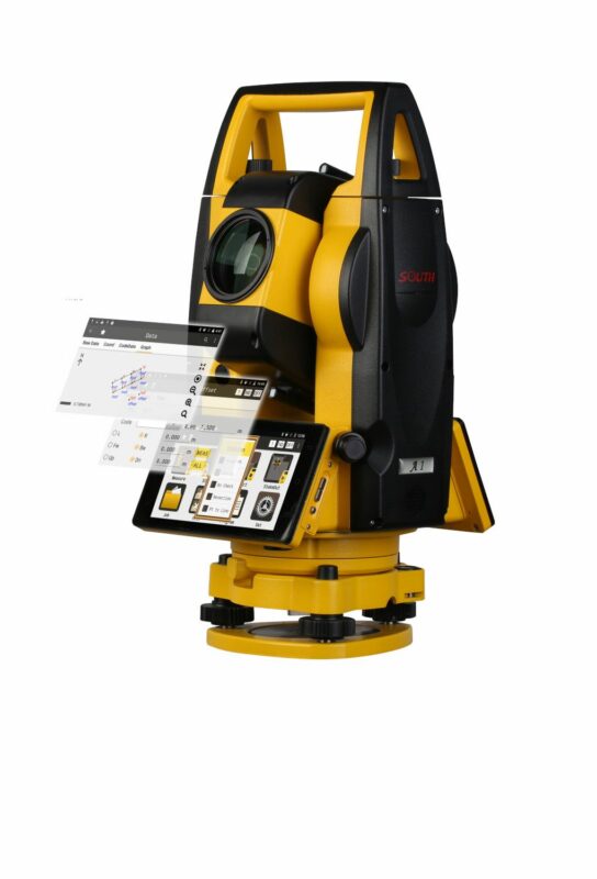
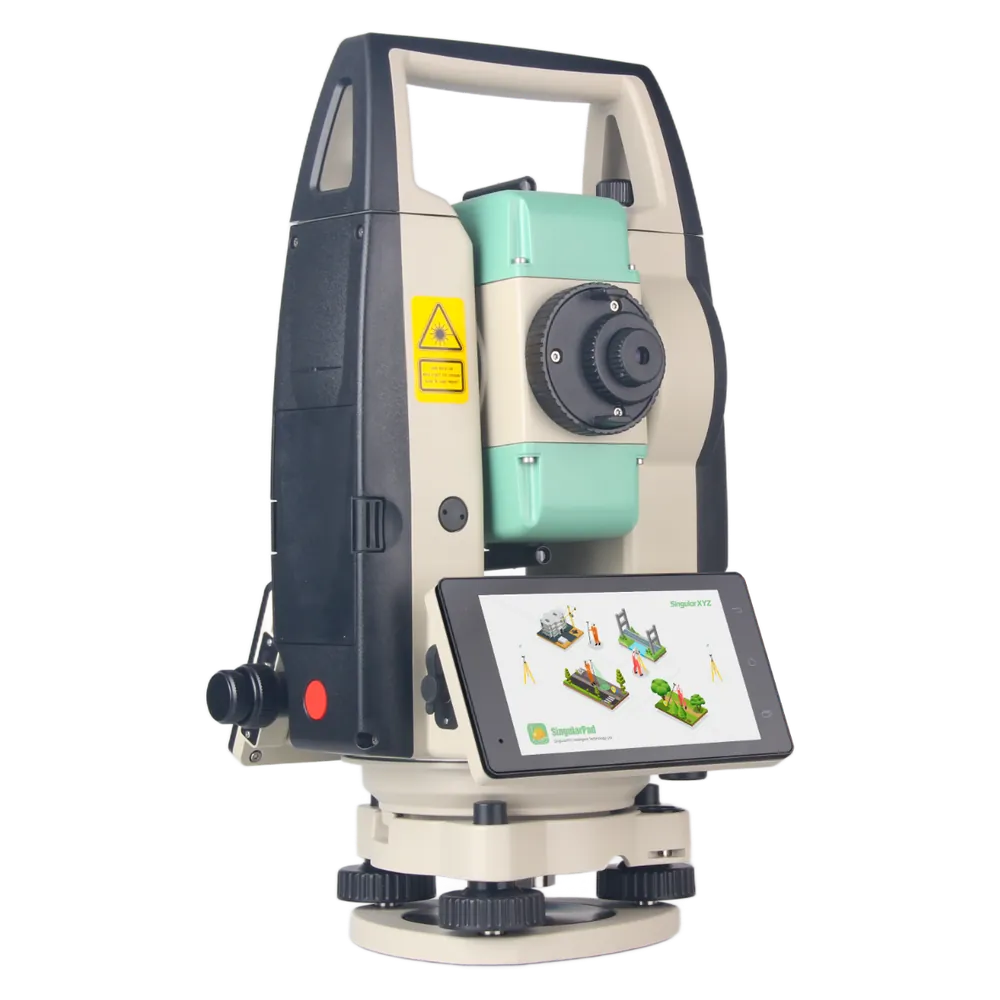
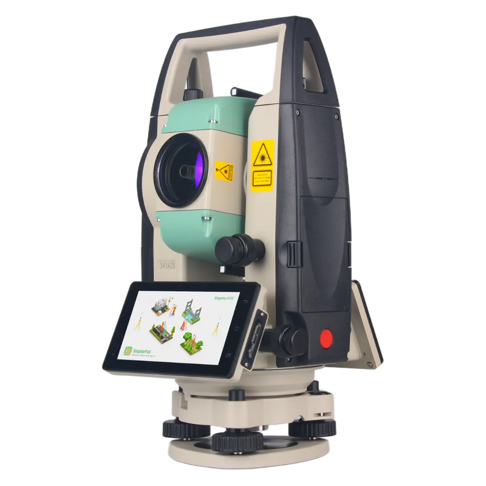
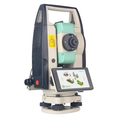
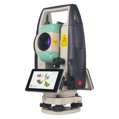
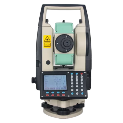
SingularXYZ STSA9 Android Total Station with 2 Second Accuracy
Get the best price for your setup
Contact our experts for the best possible price and configuration.
- Fast response
- Expert configuration advice
- No overpaying for features you do not need
The SingularXYZ STSA9 is a professional Android total station designed for land surveying, construction layout, topographic measurement and civil engineering. Combining 2″ angular accuracy with a reflectorless measuring range of up to 1,500 m and a single-prism range of 5,000 m, it provides precise optical measurements with the convenience of an integrated Android field interface.
Powered by Android 9.0 and a Qualcomm octa-core processor, the STSA9 features dual 5-inch HD touchscreens for operating surveying software directly on the instrument. Standard onboard software supports point surveying, stakeout and coordinate calculations, while optional SingularPad software adds advanced CAD and road stakeout workflows. With built-in 4G, Wi-Fi, Bluetooth, a laser plummet and up to 8 hours of battery operation, the STSA9 is a practical choice for professional surveyors and construction teams.
SingularXYZ STSA9 Highlights
| Angular accuracy | 2″ with 1″ minimum reading |
|---|---|
| Reflectorless range | Up to 1,500 m |
| Prism measurement | Up to 5,000 m with single prism; 2 mm + 2 ppm accuracy |
| Operating system | Android 9.0 with Qualcomm octa-core processor |
| Display | Dual 5-inch HD touchscreens with 1280 × 720 resolution |
| Field software | Standard onboard surveying software; optional SingularPad |
| Telescope | 30× magnification |
| Compensation | Dual-axis compensator with ±6′ range |
| Connectivity | 4G, Wi-Fi, Bluetooth 4.2 LE and USB |
| Memory | 3 GB RAM and 32 GB internal storage |
| Battery operation | Up to 8 hours with 5,000 mAh battery |
| Weight and protection | 6.0 kg; IP55 |
Valued customers:










Find RTK Networks
Search NTRIP providers and connect to reliable RTK correction services.
Description
SingularXYZ STSA9 Android Total Station for Professional Surveying
The SingularXYZ STSA9 is a professional Android total station developed for land surveying, construction stakeout, topographic mapping and civil engineering projects. Combining precise optical angle and distance measurements with an integrated Android operating system, it allows surveyors to collect points, manage projects and perform stakeout tasks directly on the instrument.
With 2″ angular accuracy, a reflectorless measurement range of up to 1,500 metres and a single-prism range of 5,000 metres, the STSA9 is suitable for a wide range of everyday surveying applications. Its dual 5-inch HD touchscreens, Qualcomm octa-core processor and flexible field software options make it particularly useful for teams that want modern data collection without relying on a separate controller for basic measurements.
The STSA9 is a manually operated total station, giving surveyors direct control over target aiming and measurement. It is a practical choice for construction sites, infrastructure projects and urban environments where conventional optical measurements remain essential.
Android Total Station with Integrated Field Software
One of the main advantages of the SingularXYZ STSA9 is its integrated Android 9.0 operating system. Instead of working with a traditional menu-based total station alone, surveyors can use a graphical interface to create projects, configure stations and manage surveying measurements.
The instrument is powered by a Qualcomm MSM8953 octa-core processor and includes 3 GB RAM and 32 GB internal storage. This provides the computing platform needed to operate the onboard surveying applications and store project information directly on the instrument.
The standard Android surveying software supports essential tasks including job creation, station setup, point measurement, stakeout and coordinate geometry calculations. For professionals who need more advanced functions, optional SingularPad software extends the available surveying workflow.
The Android platform also supports compatible third-party applications, subject to the software’s hardware and operating system requirements. This gives surveying companies flexibility when selecting tools for their established field procedures.
2 Second Angular Accuracy for Precise Survey Measurements
The SingularXYZ STSA9 provides angular accuracy of 2 arcseconds with a minimum angular reading of 1 arcsecond. This allows surveyors to measure horizontal and vertical angles for topographic surveys, construction layout and engineering control measurements.
Angular accuracy becomes particularly important when working over longer distances. Even a small angular deviation can affect the calculated position of a target, so consistent angle measurements are essential when transferring control points or setting out construction positions.
The instrument uses absolute angle encoding to record horizontal and vertical observations. Combined with its electronic distance measurement system, it calculates survey point positions from measured angles and distances.
Actual surveying accuracy also depends on instrument setup, station coordinates, target positioning, atmospheric conditions and measurement procedures. Surveyors should use appropriate control and independent checks for accuracy-sensitive projects.
Reflectorless Distance Measurement up to 1500 Metres
The STSA9 features a high-performance electronic distance measurement system capable of measuring up to 1,500 metres without a prism under suitable conditions. Reflectorless measurement allows surveyors to collect coordinates from visible surfaces without placing a target directly on the object.
This is useful when measuring building façades, walls, roofs, retaining structures and other features that are difficult or unsafe to approach. For example, a surveyor can measure a visible point on a building from a convenient instrument position rather than requiring a colleague to place a prism at that location.
Reflectorless accuracy depends on the measuring distance. The specified accuracy is 3 mm + 2 ppm from 0 to 300 metres, 5 mm + 2 ppm from 300 to 600 metres and 10 mm + 2 ppm beyond 600 metres under reference conditions.
Actual measurement range and precision also depend on surface reflectivity, target angle, weather and visibility. Dark or highly reflective surfaces may require shorter distances or a prism-based measurement.
5000 Metre Prism Range for Larger Surveying Projects
For projects requiring longer distances or measurements of precisely defined target points, the SingularXYZ STSA9 supports a single-prism range of up to 5,000 metres. Prism measurement accuracy is specified at 2 mm + 2 ppm under reference conditions.
This makes the instrument suitable for surveying control networks, collecting topographic points and measuring positions across construction or infrastructure sites where a clear line of sight is available.
During prism surveying, a survey assistant can position the target over the point to be measured while the total station operator aims the telescope and records the observation. This is particularly useful when working with ground control points, survey markers and construction reference positions.
The STSA9 supports tracking measurements in less than 0.3 seconds, continuous measurements in less than 0.7 seconds and fine measurements in less than 2 seconds under specified conditions. Operators can select the measurement method according to the task and required precision.
Dual 5 Inch HD Touchscreens for Convenient Field Operation
The STSA9 features a 5-inch LCD touchscreen on each side of the instrument, with a resolution of 1280 × 720 pixels. These displays provide access to surveying functions, project information and graphical measurement views without requiring an external controller for routine operations.
The dual-sided design is especially useful during face-left and face-right observations. Surveyors can operate the instrument from either side without repeatedly moving around the tripod to access the screen.
The touchscreens support graphical stakeout information and software interfaces that make it easier to review project coordinates and measurement results. For construction teams, this provides a more familiar working environment than conventional keypad-only total stations.
A dedicated physical measurement button is also provided, allowing users to record measurements without relying entirely on the touchscreen during fieldwork.
Optional SingularPad for Advanced Surveying and Stakeout
The STSA9 supports SingularPad, SingularXYZ’s professional field surveying software. While the standard onboard software covers basic surveying tasks, optional SingularPad provides additional tools for more demanding workflows.
Supported functions include conventional total station surveying, CAD stakeout, road stakeout, coordinate management and surveying calculations. These functions are useful when transferring design information to a construction site or collecting measurements that must be related to existing drawings.
For example, a civil engineering surveyor can work with project coordinates and road alignment information, then use the total station to position design points on site. Construction teams can use CAD-related stakeout tools to locate building corners, structural elements and other reference positions.
SingularPad also supports compatible SingularXYZ GNSS receivers, allowing total station and RTK GNSS measurements to be managed within related project workflows. This is useful when a survey begins with GNSS control measurements in open areas and continues with optical surveying close to buildings or beneath structures.
The STSA9 itself does not have an integrated GNSS receiver. Combined optical and GNSS workflows require suitable separate GNSS hardware and the relevant software configuration.
Dual Axis Compensation and Automatic Atmospheric Correction
The SingularXYZ STSA9 includes a dual-axis liquid-electric compensator with a working range of ±6 arcminutes. The compensator helps account for small deviations in instrument levelling during angle measurements.
For surveyors working on construction sites and uneven terrain, this supports stable measurement performance once the instrument has been properly set up and levelled.
The STSA9 also includes temperature and pressure sensors for automatic atmospheric correction of distance measurements. Because laser distance measurement can be affected by atmospheric conditions, this function helps apply appropriate corrections during fieldwork.
Automatic prism constant correction is also supported. The correct prism configuration and measurement settings should always be checked before beginning the survey.
30x Telescope for Accurate Target Aiming
The STSA9 uses a 30× magnification telescope with a 1°30′ field of view and a minimum focusing distance of 1.5 metres. This provides the optical magnification needed to identify and aim at suitable surveying targets across different measurement distances.
For construction stakeout, the telescope helps the operator follow a prism held by a survey assistant. During topographic surveys, it supports observations of survey markers, ground targets and other visible features.
Fine aiming is controlled through horizontal and vertical tangent screws and clamps, giving the operator direct control over instrument movement. The STSA9 is a manual total station and does not provide automatic robotic prism tracking.
Laser Plummet and Digital Levelling for Faster Setup
Accurate total station work begins with a properly positioned instrument. The STSA9 includes a built-in laser plummet, physical levelling bubbles and an on-screen digital level to assist with setup over a known survey point.
The laser plummet projects a visible reference point onto the ground, helping the operator centre the instrument above the survey station. The physical and digital levels provide feedback when adjusting the instrument on its tripod and tribrach.
These features are particularly useful on busy construction sites where equipment may be moved between several setups throughout the day. Correct centring, levelling and station orientation remain essential for reliable survey results.
4G Wi-Fi Bluetooth and USB Connectivity
The SingularXYZ STSA9 offers several communication options for transferring surveying data and connecting compatible devices. Built-in Bluetooth 4.2 LE, Wi-Fi and 4G connectivity support wireless communication, while USB interfaces provide additional options for file transfer and device connections.
For surveying teams, this flexibility makes it easier to move project information between the instrument, office systems and compatible external equipment. Wireless connectivity can also support applications that require access to network resources, depending on the selected software and available connection.
The instrument provides USB host connectivity for file access and Micro-USB for service-related functions. Supported mobile network bands and local network compatibility should be verified for the country of operation.
Built for Professional Construction and Surveying Sites
The STSA9 is designed for outdoor fieldwork, with an IP55-rated enclosure that provides protection against dust and water jets. Its specified operating temperature range of -20°C to +50°C supports surveying in a variety of working environments.
The instrument measures 206 × 200 × 353 mm and weighs approximately 6.0 kg. Its construction is intended for use on a stable surveying tripod with the appropriate tribrach and mounting accessories.
A rechargeable 7.4 V, 5,000 mAh lithium battery provides up to 8 hours of operation under specified conditions. A backup battery supports longer surveying days by allowing the operator to exchange batteries as required.
Although the instrument is designed for demanding site conditions, it should still be handled carefully and protected from impacts, unstable setups and unsuitable weather.
Applications in Surveying Construction and Civil Engineering
Topographic and Land Surveying
Land surveyors can use the STSA9 to collect terrain points, measure site features and prepare coordinate data for mapping projects. Prism and reflectorless measurements provide flexibility when working with both accessible points and surfaces that cannot easily be reached.
Construction Layout and Stakeout
Construction teams can use the STSA9 to transfer building and engineering design positions onto a project site. Typical tasks include setting out foundations, structural grid points, building corners and other construction reference locations.
The integrated Android software supports conventional stakeout functions, while optional SingularPad adds more advanced CAD-based and project-specific positioning tools.
Road and Bridge Engineering
For civil engineering projects, the STSA9 supports the measurement and layout of road alignments, bridge components and surrounding infrastructure. With suitable control coordinates and software, operators can use the instrument to position design points and record existing site features.
Building and As-Built Surveys
The reflectorless EDM makes the STSA9 useful for collecting measurements from visible building surfaces, walls, façades and structural elements. Surveyors can use the observations to prepare existing-condition drawings and check selected dimensions during renovation or construction projects.
Surveying with Limited GNSS Reception
Optical total stations are particularly useful near buildings, beneath bridges and in other locations where GNSS reception is restricted. Once suitable survey control has been established, the STSA9 can measure coordinates optically without requiring satellite visibility at every target.
Tunnel and Underground Surveys
The STSA9 can support tunnel and underground construction measurements where a suitable line of sight and survey control network are available. Surveyors can use optical observations for setting out reference points and documenting visible structural geometry.
SingularXYZ STSA9 at Global GPS Systems
The SingularXYZ STSA9 is a professional Android total station for land surveyors, construction companies and civil engineers who want precise optical measurements combined with a modern touchscreen-based field workflow.
Its combination of 2″ angular accuracy, long-range reflectorless measurement, dual HD displays, integrated connectivity and optional SingularPad software makes it suitable for everyday surveying and construction stakeout tasks.
At Global GPS Systems, we help customers select professional total stations, GNSS equipment and surveying accessories for their projects. Contact our team for guidance on the STSA9, compatible tripods and prisms, software options and the right configuration for your surveying workflow.
Datasheets & Manuals
Specifications
SingularXYZ STSA9 Android Total Station Specifications
General Specifications
| Manufacturer | SingularXYZ Intelligent Technology Ltd. |
|---|---|
| Brand | SingularXYZ |
| Product Name | SingularXYZ STSA9 Android Total Station |
| Model | STSA9 |
| Product Type | Android-based manual electronic total station |
| Operating System | Android 9.0 |
| Processor | Qualcomm MSM8953 octa-core CPU |
| System Memory | 3 GB RAM |
| Internal Storage | 32 GB ROM |
| Angle Measurement Accuracy | 2″ (arcseconds) |
| Minimum Angular Reading | 1″ |
| Maximum Reflectorless Measurement Range | 1,500 m |
| Maximum Single-Prism Measurement Range | 5,000 m |
| Prism Distance Accuracy | ±(2 mm + 2 ppm) |
| Reflectorless Distance Accuracy | Distance-dependent: ±(3 mm + 2 ppm), ±(5 mm + 2 ppm) or ±(10 mm + 2 ppm) |
| Telescope Magnification | 30× |
| Compensator | Dual-axis liquid-electric sensor |
| Compensator Range | ±6′ |
| Display | Dual-side 5-inch colour LCD touchscreens |
| Display Resolution | 1280 × 720 pixels |
| Standard Survey Software | Onboard Android surveying software |
| Optional Survey Software | SingularPad |
| Wireless Communication | Bluetooth, Wi-Fi and cellular communication |
| Wired Communication | USB host and Micro-USB; additional RS232 connectivity is mentioned in the supplied product brochure |
| Battery | 7.4 V, 5,000 mAh rechargeable lithium battery |
| Battery Operating Time | Up to 8 hours |
| Operating Temperature | -20°C to +50°C |
| Ingress Protection | IP55 |
| Dimensions | 206 × 200 × 353 mm |
| Weight | 6.0 kg |
| Primary Applications | Topographic surveying, cadastral surveying, construction layout, point and line stakeout, road and bridge engineering, tunnel surveying and control surveys |
Electronic Distance Measurement (EDM)
| Specification | Reflectorless Measurement | Single-Prism Measurement |
|---|---|---|
| Maximum Measuring Distance | 1,500 m | 5,000 m |
| Measurement Accuracy | Varies by measurement distance | ±(2 mm + 2 ppm) |
| 0–300 m Accuracy | ±(3 mm + 2 ppm) | ±(2 mm + 2 ppm) |
| 300–600 m Accuracy | ±(5 mm + 2 ppm) | ±(2 mm + 2 ppm) |
| Above 600 m Accuracy | ±(10 mm + 2 ppm) | ±(2 mm + 2 ppm) |
| Target Type | Suitable reflecting surface | Compatible surveying prism |
| Atmospheric Correction | Automatic using integrated temperature and pressure sensors | Automatic using integrated temperature and pressure sensors |
| Prism Constant Correction | Not applicable to reflectorless target | Automatic correction |
Reflectorless Distance Accuracy by Range
| Measurement Distance | Accuracy | Accuracy Components |
|---|---|---|
| 0–300 m | ±(3 mm + 2 ppm) | 3 mm constant component plus 2 ppm distance-dependent component |
| 300–600 m | ±(5 mm + 2 ppm) | 5 mm constant component plus 2 ppm distance-dependent component |
| Greater than 600 m | ±(10 mm + 2 ppm) | 10 mm constant component plus 2 ppm distance-dependent component |
Distance Measurement Speed
| Continuous Measurement Time | Less than 0.7 seconds |
|---|---|
| Tracking Measurement Time | Less than 0.3 seconds |
| Fine Measurement Time | Less than 2 seconds |
| Maximum Reflectorless Distance | 1,500 m |
| Maximum Single-Prism Distance | 5,000 m |
| Measurement Trigger | Dedicated physical measurement button |
| Measurement Trigger Location | Under the battery housing, according to the manufacturer technical table |
| Manual Target Aiming | Supported through telescope and tangent screw controls |
| Measurement Time Qualification | Actual measurement speed can depend on target reflectivity, measurement distance, visibility and selected measurement mode. |
Angle Measurement Specifications
| Angle Measurement Technology | Absolute encoding |
|---|---|
| Angle Detection Disc Diameter | 79 mm |
| Minimum Angle Reading | 1″ |
| Angular Accuracy | 2″ |
| Horizontal Angle Measurement | Supported |
| Vertical Angle Measurement | Supported |
| Horizontal Fine Adjustment | Manual tangent screw and clamp |
| Vertical Fine Adjustment | Manual tangent screw and clamp |
| Automatic Angle Compensation | Supported by dual-axis compensator |
| Angle Units | Degrees, minutes and seconds in the published technical specifications |
| Angular Accuracy Qualification | The 2″ value specifies angular measurement accuracy, while 1″ is the minimum angular reading. |
Telescope and Optical Specifications
| Telescope Type | Optical surveying telescope |
|---|---|
| Magnification | 30× |
| Effective Aperture | 45 mm |
| Distance Measurement Aperture | 47 mm |
| Telescope Field of View | 1°30′ |
| Minimum Focusing Distance | 1.5 m |
| Telescope Resolution | 3″ |
| Image Orientation | Erect |
| Telescope Tube Length | 150 mm |
| Manual Aiming | Supported |
| Tangent Screw Adjustment | Horizontal and vertical fine aiming controls |
| Automatic Robotic Target Tracking | Not specified; the STSA9 uses manual telescope aiming and manual angle adjustment |
| Automatic Target Recognition | Not specified in the manufacturer datasheet |
Dual-Axis Compensation and Atmospheric Correction
| Compensator Type | Dual-axis liquid-electric sensor |
|---|---|
| Compensator Axes | 2 |
| Compensator Range | ±6′ |
| Correction Unit | ±3″ as printed in the manufacturer datasheet |
| Temperature Sensor | Integrated |
| Pressure Sensor | Integrated |
| Atmospheric Correction | Automatic temperature and pressure sensor correction |
| Prism Constant Correction | Automatic |
| Automatic Tilt Compensation | Supported within the compensator range |
| Digital Level Bubble | Supported |
| Physical Level Vials | Integrated |
| Compensator Range Qualification | ±6′ is the angular operating range of the compensator. This should not be confused with the 2″ instrument angular accuracy. |
Levelling and Centring
| Circular Bubble Level | Integrated |
|---|---|
| Circular Level Sensitivity | 8′ / 2 mm |
| Plate Bubble Level | Integrated |
| Plate Level Sensitivity | 30″ / 2 mm |
| Digital Level Bubble | Integrated on-screen levelling function |
| Plummet Type | Laser plummet |
| Laser Centring | Supported |
| Instrument Levelling | Physical level vials, digital level display and dual-axis compensator |
| Laser Plummet Wavelength | Not specified in the manufacturer STSA9 datasheet |
| Laser Plummet Accuracy | Not specified in the manufacturer STSA9 datasheet |
| Laser Plummet Safety Class | Not specified in the manufacturer STSA9 datasheet |
Android System and Processing Hardware
| Operating System | Android 9.0 |
|---|---|
| Processor Manufacturer | Qualcomm |
| Processor Model | MSM8953 |
| Processor Architecture | Octa-core CPU |
| System RAM | 3 GB |
| Internal ROM | 32 GB |
| Android Application Support | Compatible third-party Android applications, subject to hardware, operating system and app requirements |
| Onboard Survey Calculations | Supported |
| Onboard Project Management | Supported through installed surveying software |
| Onboard Point Surveying | Supported |
| Onboard Stakeout | Supported |
| Onboard Coordinate Geometry (COGO) | Supported |
| Optional Advanced Software | SingularPad |
| Operating System Qualification | Android 9.0 is the manufacturer-published platform. Compatibility with newer third-party applications must be checked individually. |
Display and Operator Controls
| Display Configuration | Dual-side LCD graphic touchscreens |
|---|---|
| Number of Displays | 2 |
| Display Size | 5 inches per display |
| Display Resolution | 1280 × 720 pixels |
| Display Type | Colour LCD touchscreen |
| Outdoor Display Readability | Sunlight-readable display design according to manufacturer documentation |
| Graphic Survey Interface | Supported |
| Onboard CAD Drawing Display | Supported through compatible Android surveying software |
| Stakeout Graphics | Supported |
| Map Layers | Supported through compatible surveying applications |
| Digital Level Display | Supported |
| Dedicated Physical Measure Button | Included |
| Manual Horizontal Aiming Controls | Clamp and tangent screw |
| Manual Vertical Aiming Controls | Clamp and tangent screw |
| Maximum Graphic Distance Display | 99,999,999.999 m as specified in the manufacturer datasheet |
| Minimum Graphic Distance Display Increment | 0.1 mm as specified in the manufacturer datasheet |
| Display Qualification | The graphic display increment is not equivalent to EDM measurement accuracy. |
Bluetooth and Wi-Fi Communication
| Bluetooth | Integrated |
|---|---|
| Bluetooth Version | 4.2 LE |
| Wi-Fi | Integrated |
| Wi-Fi Standards | IEEE 802.11b/g |
| Wi-Fi Frequency Range | 2402–2482 MHz as printed in the manufacturer datasheet |
| Wi-Fi Frequency Band | 2.4 GHz |
| Wireless Data Communication | Supported |
| Android Software Connectivity | Supported |
| Field Data Synchronisation | Available through compatible applications and network connections |
| Wi-Fi 5 GHz Support | Not specified in the manufacturer technical datasheet |
| Bluetooth Range | Not specified in the manufacturer technical datasheet |
Cellular Communication Specifications
| Integrated Cellular Communication | Supported |
|---|---|
| 4G TDD-LTE Bands | B34, B38, B40, B41 |
| 4G FDD-LTE Bands | B1, B3, B5, B8 |
| GSM Frequency Bands | 900 MHz / 1800 MHz |
| CDMA Band | BC0 |
| WCDMA Bands | B1 / B8 |
| Mobile Data Connectivity | Supported with a compatible mobile network and service |
| Regional Network Compatibility | Dependent on the mobile operator, frequency bands, SIM/service configuration and regional hardware |
| 5G Cellular Support | Not specified in the manufacturer datasheet |
| SIM Card Format | Not specified in the manufacturer datasheet |
| Cellular Communication Qualification | The presence of a cellular modem does not guarantee compatibility with every regional mobile operator. |
Wired Connectivity and Data Transfer
| USB Host | Supported |
|---|---|
| USB Host Function | USB storage access and file transfer |
| Micro-USB | Supported |
| Micro-USB Function | System debugging and compatible data communication |
| Audio Jack | Mentioned in the manufacturer product description |
| RS232 | Mentioned in the supplier-hosted product brochure; interface specifications are not provided |
| External USB Storage | Supported |
| USB File Transfer | Supported |
| Wireless File Transfer | Supported through compatible network applications |
| Native Instrument File Formats | Not individually specified in the STSA9 technical datasheet |
| Data Export Options | Depend on the onboard surveying software or optional SingularPad application |
Standard Onboard Surveying Software
| Software Type | Android onboard surveying application |
|---|---|
| Standard Inclusion | Default software supplied according to the manufacturer |
| Job Creation | Supported |
| Project Management | Supported |
| Station Setup | Supported |
| Point Survey | Supported |
| Point Stakeout | Supported |
| Coordinate Geometry Calculations | Supported |
| Survey Point Collection | Supported |
| Instrument Control | Supported through the integrated touchscreen interface |
| Advanced CAD and Road Workflows | Available through compatible optional SingularPad software |
| Third-Party Android Applications | Installation supported where application compatibility and system permissions permit |
Optional SingularPad Field Surveying Software
| Software Name | SingularPad |
|---|---|
| Software Availability | Optional |
| STS Total Station Integration | STSA9 supported |
| TPS Surveying | Supported |
| Point Surveying | Supported |
| Control Point Surveying | Supported |
| Point Stakeout | Supported |
| Line Stakeout | Supported |
| CAD Sketching | Supported |
| CAD Stakeout | Supported |
| Road Stakeout | Supported |
| Coordinate Conversion | Supported |
| Angle Conversion | Supported |
| Area Calculation | Supported |
| Perimeter Calculation | Supported |
| COGO Calculations | Supported |
| Datum Configuration | Supported |
| Coordinate Localisation | Supported |
| Point Database Management | Supported |
| Survey Code Management | Supported |
| Project File Sharing | Supported |
| GNSS and Optical Project Integration | Supported through compatible connected instruments and software workflows |
| Software Scope Qualification | SingularPad supports both GNSS and optical survey devices. GNSS-only functions require a compatible external GNSS receiver and are not native STSA9 measurement functions. |
Data Handling and Project Integration
| Internal System Storage | 32 GB ROM |
|---|---|
| Onboard Survey Project Storage | Supported |
| Point Coordinate Storage | Supported |
| Project Data Transfer | USB storage and compatible wireless communication |
| CAD Data Display | Supported through compatible surveying software |
| CAD Stakeout Data | Supported through optional SingularPad |
| Optical Survey Data | Angle, distance and calculated survey coordinates |
| Survey Project Coordinate Systems | Managed through supported surveying software |
| Survey Data Export | Supported through the installed software |
| CAD Interoperability | Dependent on compatible software import/export functions |
| Native Instrument File Formats | Not individually listed in the STSA9 manufacturer technical datasheet |
| Point Storage Limit | No specific point-count limit published; manufacturer specifies 32 GB internal ROM |
Battery and Electrical Specifications
| Battery Type | Rechargeable lithium battery |
|---|---|
| Battery Voltage | 7.4 V DC |
| Battery Capacity | 5,000 mAh |
| Nominal Battery Energy | 37 Wh, calculated from 7.4 V × 5 Ah |
| Published Operating Time | Up to 8 hours |
| Backup Battery | Included according to the manufacturer product description |
| Replaceable Battery | Supported |
| Charging Time | Not specified in the manufacturer technical datasheet |
| Battery Charging Input | Not specified in the manufacturer technical datasheet |
| Average Instrument Power Consumption | Not specified in the manufacturer technical datasheet |
| Battery Runtime Qualification | The manufacturer specifies 8 hours under its operating conditions. Actual runtime depends on battery condition, screen brightness, connectivity and measurement workload. |
Physical and Mechanical Specifications
| Instrument Type | Manual Android electronic total station |
|---|---|
| Length | 206 mm |
| Width | 200 mm |
| Height | 353 mm |
| Overall Dimensions | 206 × 200 × 353 mm |
| Weight | 6.0 kg |
| Telescope | 30× optical telescope |
| Display Arrangement | Dual-side 5-inch touchscreens |
| Manual Horizontal Adjustment | Clamp and tangent screw |
| Manual Vertical Adjustment | Clamp and tangent screw |
| Laser Plummet | Integrated |
| Physical Levelling Vials | Integrated circular and plate levels |
| Digital Level | Integrated software display |
| Dual-Axis Compensator | Integrated |
| Physical Measurement Trigger | Integrated |
| Battery Configuration | Rechargeable and replaceable |
| Tripod Mounting | Compatible total station tripod and mounting assembly required |
| Ingress Protection | IP55 |
Environmental Specifications
| Operating Temperature | -20°C to +50°C |
|---|---|
| Storage Temperature | -40°C to +50°C |
| Ingress Protection Rating | IP55 |
| Dust Protection | IP5X — dust-protected enclosure |
| Water Protection | IPX5 — protection against water jets |
| Outdoor Surveying | Supported within the manufacturer environmental limits |
| Temperature and Pressure Sensors | Integrated for automatic atmospheric EDM correction |
| Operating Humidity | Not specified in the manufacturer technical datasheet |
| Shock or Drop Resistance | Not specified in the manufacturer technical datasheet |
| Storage Temperature Qualification | The manufacturer datasheet specifies a maximum storage temperature of +50°C. |
| Environmental Protection Qualification | IP55 does not indicate waterproof or submersible construction. Protect the instrument against immersion and exposure beyond the specified environmental conditions. |
Surveying and Engineering Applications
| Topographic Surveying | Collection of ground and surface feature positions using angle and distance measurement |
|---|---|
| Cadastral Surveying | Boundary point measurement and parcel surveys |
| Construction Layout | Setting out building positions and design reference points |
| Building Axis Setting Out | Layout of structural axes and grid lines |
| Foundation Layout | Positioning foundation points and construction references |
| Point Surveying | Electronic measurement of survey point coordinates |
| Point Stakeout | Setting out specified point coordinates |
| Line Stakeout | Supported by compatible field software |
| CAD Stakeout | Supported by optional SingularPad |
| Road Stakeout | Supported by optional SingularPad |
| Road Engineering | Optical survey and construction positioning workflows |
| Bridge Engineering | Structural measurement, layout and as-built surveying |
| Tunnel Surveying | Underground optical measurement where GNSS reception is unavailable |
| Control Network Surveying | Angle and distance measurement for survey control networks |
| As-Built Surveying | Measurement of constructed elements and installed infrastructure |
| Reflectorless Surveying | Non-contact measurement to suitable target surfaces |
| Prism-Based Surveying | Long-distance measurement using a compatible prism |
| Project Data Integration | Optical survey data management and optional GNSS project integration through SingularPad |
Package Contents and Accessories
| Item | Quantity | Notes |
|---|---|---|
| SingularXYZ STSA9 Android Total Station | 1 instrument | Main electronic total station with Android operating system |
| Integrated Telescope | 1 | 30× optical telescope |
| Integrated Touchscreens | 2 | 5-inch, 1280 × 720 pixels |
| Integrated Laser Plummet | 1 | Laser centring system |
| Rechargeable Lithium Battery | 1 operating battery | 7.4 V, 5,000 mAh |
| Backup Lithium Battery | 1 additional battery | Manufacturer product documentation describes a backup battery |
| Standard Android Survey Software | 1 onboard software installation | Default project setup, point survey, stakeout and COGO functionality |
| SingularPad Survey Software | Optional | Advanced TPS surveying, CAD stakeout and road stakeout workflows |
| Battery Charging Equipment | Configuration-dependent | Confirm exact charger and power accessories |
| Total Station Tripod | Configuration-dependent | Not confirmed as part of the standard instrument package |
| Survey Prism | Configuration-dependent | Required for single-prism measurement; verify inclusion |
| Tribrach and Mounting Hardware | Configuration-dependent | Confirm supplied mechanical mounting components |
| USB Data Accessories | Configuration-dependent | USB host and Micro-USB supported |
| Protective Transport Case | Not confirmed | Verify against the supplier packing list |
| Operating Documentation | Configuration-dependent | Manufacturer datasheet and applicable user documentation |
Manufacturer Documentation and Technical Notes
| Product Page | Global GPS Systems – Singular XYZ STSA9 |
|---|---|
| Supplier-Hosted Datasheet | STSA9 Android Total Station Datasheet (PDF) |
| Supplier-Hosted Datasheet Version | 12-04-2025 |
| Manufacturer Product Page | SingularXYZ STSA9 Android Total Station |
| Manufacturer Updated Datasheet | SingularXYZ STSA9 Android Total Station Datasheet, Version 10-07-2025 (PDF) |
| Optional Software Information | SingularPad Field Surveying Software |
| Reflectorless EDM Accuracy Note | Accuracy varies by measurement distance: 3 mm + 2 ppm from 0–300 m, 5 mm + 2 ppm from 300–600 m, and 10 mm + 2 ppm above 600 m. |
| Prism EDM Accuracy Note | The manufacturer lists 2 mm + 2 ppm with a single prism, subject to suitable measurement conditions. |
| Angular Accuracy Note | Angle accuracy is 2 arcseconds; minimum angle reading is 1 arcsecond. These are different specifications. |
| Compensator Correction Note | The manufacturer datasheet prints the correction unit as ±3″. This value is reproduced as published and is distinct from the compensator operating range of ±6′. |
| Communication Note | The official technical table confirms Bluetooth 4.2 LE, 2.4 GHz Wi-Fi and the listed cellular bands. The product description also mentions USB host, Micro-USB and an audio jack; the supplier brochure references RS232 without detailed electrical specifications. |
| Android Software Note | Standard onboard survey software and optional SingularPad provide different functionality. Advanced CAD and road stakeout operations require appropriate software support. |
| GNSS Compatibility Note | The STSA9 is an optical total station, not an integrated GNSS receiver. GNSS survey project integration requires a compatible external GNSS instrument. |
| Battery Specification Note | The published 8-hour runtime refers to the 5,000 mAh battery configuration. The manufacturer separately describes a backup battery. |
| Package Contents Note | The manufacturer confirms a backup battery and default onboard survey software, but does not provide a complete itemised commercial packing list in the reviewed technical datasheets. |
| Model Identification | These specifications apply specifically to the SingularXYZ STSA9 Android Total Station and should not be substituted with those of the SingularXYZ STS2 or TS1000. |
Specifications and package contents may vary by configuration, region or manufacturer update. Always check the current configuration before ordering.
Reviews (0)
Only logged in customers who have purchased this product may leave a review.
FAQ
SingularXYZ STSA9 Android Total Station FAQ
General Information and Key Features
What is the SingularXYZ STSA9 Android Total Station?
The SingularXYZ STSA9 is a professional Android total station designed for precise angle measurement, distance measurement, land surveying and construction stakeout. It combines 2-second angular accuracy, reflectorless measurements up to 1,500 meters and prism measurements up to 5,000 meters with an integrated Android 9 operating system. The instrument features dual 5-inch HD touchscreens, a Qualcomm octa-core processor and support for SingularPad field surveying software. It is suitable for topographic surveying, construction layout, cadastral measurement, civil engineering and infrastructure projects.
What are the main features of the SingularXYZ STSA9?
The SingularXYZ STSA9 features 2-second angular accuracy, reflectorless distance measurement up to 1,500 meters, single-prism measurement up to 5,000 meters and a 30x optical telescope. Its Android 9 operating system runs on a Qualcomm MSM8953 processor with 3 GB RAM and 32 GB internal storage. Additional features include dual 5-inch HD touchscreens, a dual-axis electronic compensator, laser plummet, integrated temperature and pressure correction, Bluetooth, Wi-Fi, 4G connectivity, USB data transfer and IP55 environmental protection.
How accurate is the SingularXYZ STSA9 Total Station?
The SingularXYZ STSA9 provides an angular measurement accuracy of 2 arcseconds (2"). Its electronic distance measurement system offers an accuracy of 2 mm + 2 ppm when measuring with a prism. Reflectorless distance accuracy depends on measurement range: 3 mm + 2 ppm from 0 to 300 meters, 5 mm + 2 ppm from 300 to 600 meters and 10 mm + 2 ppm beyond 600 meters. These specifications apply under manufacturer reference conditions. Actual measurement accuracy depends on instrument setup, atmospheric conditions, target characteristics and surveying procedures.
What is the maximum measuring distance of the SingularXYZ STSA9?
The SingularXYZ STSA9 supports reflectorless distance measurements up to 1,500 meters and single-prism measurements up to 5,000 meters. Reflectorless mode allows operators to measure suitable surfaces without placing a prism at the target location. Prism measurement is useful for longer distances and conventional survey control workflows. Actual measuring range depends on atmospheric visibility, target reflectivity, prism condition and the measurement environment.
What is the advantage of Android 9 on the SingularXYZ STSA9?
The SingularXYZ STSA9 uses Android 9.0 with a Qualcomm MSM8953 octa-core processor, 3 GB RAM and 32 GB internal storage. This allows compatible surveying applications to run directly on the total station instead of requiring a separate external controller for every operation. Surveyors can manage projects, view graphics, perform calculations and access supported field software through the integrated touchscreens. Android also provides flexibility for compatible third-party applications, although software compatibility should be verified before installation.
What is the difference between the SingularXYZ STSA9 and STS2 Total Stations?
Both the SingularXYZ STSA9 and STS2 are manual total stations with 2-second angular accuracy, a 30x telescope and prism measurement capabilities up to 5,000 meters. The STSA9 provides an extended reflectorless range of 1,500 meters compared with 1,000 meters on the STS2. It also features Android 9, dual 5-inch HD touchscreens, integrated 4G and Wi-Fi, and support for running compatible Android surveying applications directly on the instrument. The STS2 uses smaller conventional displays and a more traditional operating interface. The STSA9 is especially suitable for users who prefer integrated digital surveying workflows.
Applications and Professional Surveying
What industries and professionals use the SingularXYZ STSA9?
The SingularXYZ STSA9 is designed for land surveyors, cadastral surveyors, construction surveyors, civil engineers, infrastructure contractors and geospatial professionals. Typical applications include topographic surveying, property boundary measurement, construction layout, road engineering, control point measurement and infrastructure documentation. Its combination of precise optical measurements and Android-based field software is particularly useful for survey teams working with digital drawings, coordinate databases and stakeout projects.
Can the SingularXYZ STSA9 be used for topographic and land surveying?
Yes. The SingularXYZ STSA9 is suitable for professional topographic surveying, land measurement and terrain mapping. It measures horizontal angles, vertical angles and distances to calculate the coordinates and elevations of survey points. Surveyors can use the collected information to map terrain features, roads, structures, boundaries and other site elements. With compatible surveying software, the instrument also supports point databases, coordinate calculations and project management.
Is the SingularXYZ STSA9 suitable for construction stakeout and building layout?
Yes. The SingularXYZ STSA9 supports construction layout and stakeout workflows using its integrated measurement system and compatible SingularPad software. Surveyors can set out design coordinates for foundations, building corners, structural grid lines, columns, walls and other construction elements. Supported software provides point and line stakeout functions, graphical guidance and coordinate calculations. The instrument's 2-second angular accuracy and millimeter-level distance measurement specifications make it suitable for precision construction work when proper survey procedures are followed.
Can the SingularXYZ STSA9 be used for cadastral and property boundary surveys?
Yes. The SingularXYZ STSA9 can be used to measure property corners, boundary markers, control points and distances during cadastral and land subdivision surveys. Its prism and reflectorless measurement modes provide flexibility for surveying accessible and difficult-to-reach features. Survey measurements can be managed using compatible coordinate databases and field software. Legal boundary determination must follow applicable surveying regulations, official records and local coordinate reference requirements.
Can the SingularXYZ STSA9 be used for road construction and infrastructure projects?
Yes. The SingularXYZ STSA9 is suitable for road construction, railway-related surveying, drainage projects and civil engineering infrastructure. With compatible SingularPad software, operators can measure existing site features, establish survey control, perform point and line stakeout and work with road alignment information. Its integrated Android interface allows graphical surveying information to be displayed directly on the total station. These functions support construction positioning, elevation verification and infrastructure documentation.
Can the SingularXYZ STSA9 operate where GPS or GNSS signals are unavailable?
Yes. The SingularXYZ STSA9 determines survey coordinates using optical angle measurements and electronic distance measurements rather than relying on satellite signals. It can therefore operate in locations where GNSS reception is obstructed, including near tall buildings, under bridges and inside suitable structures. The instrument requires a clear optical line of sight to the target and a properly established survey station. Known control points or an appropriate local coordinate system are required when measurements must be connected to real-world coordinates.
Technical Specifications and Hardware
What telescope magnification does the SingularXYZ STSA9 have?
The SingularXYZ STSA9 features a 30x optical telescope with an effective aperture of 45 mm, a field of view of 1 degree 30 minutes and a minimum focusing distance of 1.5 meters. The telescope provides an upright image and supports accurate manual sighting of surveying prisms and other targets. Its optical specifications make it suitable for conventional surveying, control point measurement and construction layout over a wide range of distances.
Does the SingularXYZ STSA9 have dual touchscreens?
Yes. The SingularXYZ STSA9 features two 5-inch LCD graphic touchscreens, one on each side of the instrument. Each display has a resolution of 1280 × 720 pixels and is designed to remain readable in bright outdoor conditions. The dual-sided arrangement allows operators to control surveying applications, review measurement information and view graphical data from either telescope position. This is useful when working in face-left and face-right measurement configurations.
Does the SingularXYZ STSA9 have a dual-axis compensator?
Yes. The SingularXYZ STSA9 uses a dual-axis liquid-electric compensator with a working range of ±6 arcminutes. The manufacturer specifies a correction unit of ±3 arcseconds. The compensator helps correct small deviations from level during angle measurements, improving measurement reliability. The instrument also includes physical leveling indicators and digital level bubbles for instrument setup. A stable tripod and accurate initial leveling remain important for professional surveying.
Does the SingularXYZ STSA9 include a laser plummet?
Yes. The SingularXYZ STSA9 includes an integrated laser plummet for positioning the instrument over a survey station or control point. The visible laser makes it easier to align the total station with the ground mark during setup. Accurate centering is important for maintaining measurement quality, especially during control surveys and construction stakeout. Operators should use the laser plummet together with proper tripod setup, leveling and station orientation procedures.
How fast does the SingularXYZ STSA9 measure distances?
The SingularXYZ STSA9 offers several electronic distance measurement modes. The specified measurement time is less than 0.3 seconds in tracking mode, less than 0.7 seconds in continuous mode and less than 2 seconds in fine measurement mode. Tracking is useful when positioning a prism during stakeout or monitoring changing distances, while fine measurement is intended for precise survey observations. Actual measurement times may vary depending on atmospheric conditions, target characteristics and instrument settings.
How much does the SingularXYZ STSA9 weigh and what are its dimensions?
The SingularXYZ STSA9 weighs approximately 6.0 kg and measures 206 × 200 × 353 mm. Its housing integrates the optical telescope, EDM system, dual-sided 5-inch displays, Android computing hardware, communication interfaces, compensator and laser plummet. The complete surveying setup also requires suitable accessories such as a tripod, tribrach and prism equipment, depending on the intended application.
What are the battery life and environmental protection specifications of the STSA9?
The SingularXYZ STSA9 uses a rechargeable 7.4 V, 5,000 mAh lithium-ion battery with a specified operating time of approximately 8 hours under manufacturer reference conditions. A backup battery is also identified in the manufacturer's documentation. The instrument has an IP55 dust and water protection rating and an operating temperature range of -20°C to +50°C. IP55 provides protection against dust ingress and water jets but does not make the instrument suitable for immersion. Actual battery endurance depends on display brightness, wireless connectivity and operating conditions.
Software, Connectivity and Surveying Workflow
Which surveying software is compatible with the SingularXYZ STSA9?
The SingularXYZ STSA9 includes onboard Android surveying software for basic field measurement workflows and supports SingularPad as an optional advanced surveying application. SingularPad provides project management, point surveying, coordinate calculations, CAD-related functions, construction stakeout and road stakeout tools. The instrument's Android operating system also allows compatible third-party applications to be installed. Available software features depend on the installed application version, license and system compatibility.
Can SingularPad run directly on the SingularXYZ STSA9?
Yes. The SingularXYZ STSA9 uses Android 9.0 and supports installing compatible versions of SingularPad directly on the instrument. This allows surveyors to manage projects, perform measurements, calculate coordinates and carry out stakeout tasks through the integrated 5-inch touchscreens without always requiring a separate Android controller. SingularPad is identified by the manufacturer as an optional software solution, so its availability and licensing should be verified for the selected configuration.
Does the SingularXYZ STSA9 support Bluetooth, Wi-Fi and 4G connectivity?
Yes. The SingularXYZ STSA9 includes Bluetooth 4.2 LE, Wi-Fi and integrated 4G cellular connectivity. It also provides USB host connectivity, a Micro-USB interface and an audio connection. These communication options support data transfer, compatible software integration and connected field workflows. The integrated cellular modem supports specified LTE and other mobile network bands, but actual 4G compatibility depends on regional frequency availability, network operators and the installed SIM configuration.
Can the SingularXYZ STSA9 be used together with RTK GNSS surveying equipment?
Yes. The SingularXYZ STSA9 can be used in a surveying workflow alongside compatible RTK GNSS receivers through SingularPad software. Surveyors can use GNSS equipment to measure points in open-sky locations and the total station to collect optical measurements where satellite reception is obstructed. By using consistent project coordinates and control points, measurements from both methods can be managed within the same project. The STSA9 itself is an optical total station and does not contain an integrated RTK GNSS receiver.
Can the SingularXYZ STSA9 display CAD drawings and perform CAD-based stakeout?
Yes. The SingularXYZ STSA9 supports graphical surveying workflows through its Android operating system and compatible software such as SingularPad. Surveyors can view CAD-related project information, manage point databases and perform point, line and supported road stakeout operations. The dual 5-inch touchscreens provide a larger graphical interface than conventional small-display total stations. CAD functionality depends on the installed software, supported drawing formats and project configuration.
How are survey measurements stored and transferred from the SingularXYZ STSA9?
The SingularXYZ STSA9 includes 32 GB of internal storage and 3 GB of RAM for its Android operating system, surveying applications and project data. It supports data transfer through USB host, Micro-USB, Bluetooth, Wi-Fi and compatible mobile network connections. Survey measurements can be managed using the onboard software or SingularPad and transferred for further processing in CAD, GIS or office surveying applications. Available file formats and sharing methods depend on the installed surveying software. Regular backups are recommended for important project data.
 GPS & GNSS
 Total Stations
 Data collectors
 Software
 Correction services
 Machine control
 External radio
 Marine
 Accessories
Reviews
There are no reviews yet