

 GPS & GNSS
 Lidar scanning
 Total Station
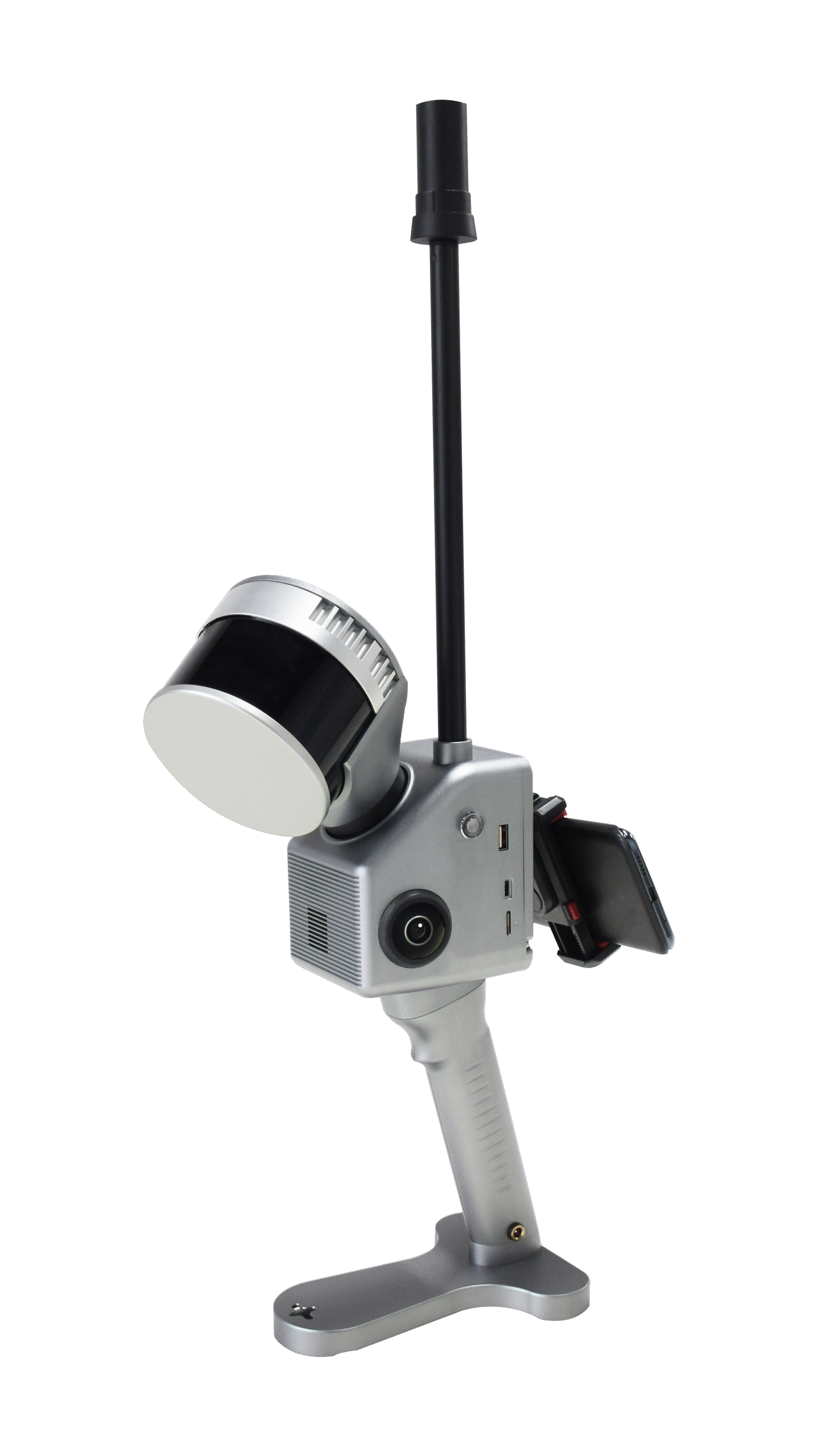
Geosun GS 120G 120m Handheld SLAM LiDAR Scanner
Get the best price for your setup
Contact our experts for the best possible price and configuration.
- Fast response
- Expert configuration advice
- No overpaying for features you do not need
The Geosun GS-120G is a handheld SLAM LiDAR scanner designed for fast 3D mapping indoors, outdoors and in locations where GNSS reception is weak or unavailable. It combines a 32-channel LiDAR, GNSS/INS positioning, SLAM technology and dual 20 MP cameras in one portable system. With a measuring range of up to 120 m, a point rate of 1.28 million points per second and absolute point-cloud accuracy of up to 5 cm, the GS-120G is suitable for building surveys, construction sites, underground spaces, mines, stockpiles, infrastructure and detailed urban mapping.
Geosun GS-120G Highlights
| LiDAR range | Up to 120 m |
|---|---|
| Absolute accuracy | ≤5 cm |
| Laser channels | 32-channel LiDAR |
| Point rate | Up to 1,280,000 points/sec |
| Field of view | 270° vertical × 360° horizontal |
| Cameras | Dual 20 MP cameras |
| Mapping modes | SLAM, RTK-SLAM and PPK-SLAM |
| GNSS / INS | gSpin 210 with 200 Hz IMU update rate |
Valued customers:










Find RTK Networks
Search NTRIP providers and connect to reliable RTK correction services.
Description
Fast handheld 3D mapping with SLAM LiDAR
The Geosun GS-120G is a portable SLAM LiDAR mapping system developed for surveyors, engineers, construction teams, GIS professionals, mine operators and 3D-mapping specialists who need to capture complete environments quickly. Instead of measuring individual points or repeatedly repositioning a static laser scanner, the operator can walk through the project area while the GS-120G continuously records the surroundings and builds a three-dimensional point cloud.
The system combines LiDAR, GNSS, inertial navigation and SLAM algorithms in one unit. This allows it to work outdoors with satellite positioning as well as indoors, underground or between buildings where GNSS reception becomes unreliable.
32-channel LiDAR with 1.28 million points per second
The GS-120G uses a 32-channel laser scanner capable of recording up to 1,280,000 points per second. The high measurement rate helps create dense point clouds while the operator is moving, providing detailed geometric information for walls, floors, terrain, structures, machinery, stockpiles and other objects.
For fieldwork, the amount of detail collected depends on walking speed, distance to the surfaces and the route used through the site. Moving more slowly or passing closer to important objects generally increases the amount of usable information captured in those areas.
120 metre measuring range
The GS-120G offers a maximum LiDAR measuring range of approximately 120 m. Geosun also specifies approximately 80 m at 10% target reflectivity in its product material, illustrating how surface reflectivity influences practical working distance.
This range makes the scanner suitable for much more than room-scale scanning. It can be used in large industrial buildings, underground garages, mine workings, urban streets, outdoor terrain and other environments where surfaces may be tens of metres away from the operator.
SLAM mapping where GNSS is unavailable
A key feature of the GS-120G is its SLAM technology. SLAM, or Simultaneous Localization and Mapping, allows the system to calculate its movement by comparing the surrounding geometry between successive scans while building the point cloud at the same time.
In practical terms, this means the operator can continue surveying inside buildings, tunnels, underground garages and other GNSS-denied environments. The system does not need continuous satellite reception to maintain the local mapping trajectory, which is a major advantage compared with conventional GNSS-only surveying equipment.
SLAM RTK-SLAM and PPK-SLAM workflows
The GS-120G supports SLAM, RTK-SLAM and PPK-SLAM mapping methods. Standard SLAM is useful for fully indoor or underground work. RTK-SLAM can use real-time GNSS corrections when satellite signals and correction services are available, while PPK-SLAM allows GNSS trajectory information to be processed after data collection.
This gives survey teams flexibility on mixed projects. An operator can begin outside with GNSS positioning, walk into a building or covered environment and continue collecting data using SLAM without having to stop the survey and switch to a completely different instrument.
GNSS and INS for georeferenced surveys
The GS-120G uses the Geosun gSpin 210 GNSS/INS positioning system with a 200 Hz IMU update rate. It supports GPS, GLONASS, Galileo and BeiDou satellite signals and provides the positioning information needed to connect SLAM data to a real-world coordinate system when GNSS is available.
The published specifications list GNSS positioning accuracy of approximately 2 cm horizontally and 3 cm vertically under suitable positioning conditions, together with pitch and roll accuracy of 0.015° and heading accuracy of 0.040°. These positioning values describe the GNSS/INS unit itself; final point-cloud accuracy also depends on the survey environment, SLAM trajectory, control and processing workflow.
Up to 5 cm absolute point-cloud accuracy
The GS-120G is specified with an absolute point-cloud accuracy of ≤5 cm. This makes it suitable for many mapping, documentation, volume and spatial-analysis workflows where collecting a complete 3D representation quickly is more important than millimetre-level static scanning.
For engineering work with strict tolerances, surveyors should still use suitable control and independent checks. SLAM accuracy can be influenced by route length, environment geometry, repetitive structures, walking speed and whether the survey route contains useful loop closures.
Wide 270 by 360 degree field of view
The laser scanner provides approximately 270° vertical and 360° horizontal coverage. This wide field of view allows the GS-120G to record nearly the complete environment around the operator rather than scanning only in one direction.
For indoor surveys this means floors, ceilings, walls and structural elements can be collected during the same walking pass. In tunnels, streets or industrial spaces, the scanner can capture geometry on both sides and above the user without constant manual aiming.
Dual 20 MP cameras for coloured point clouds
The GS-120G includes two 20 MP cameras with approximately 270° horizontal image coverage. The camera data can be combined with the LiDAR geometry to create coloured point clouds and make the resulting dataset easier to interpret.
Colour is particularly useful when users need to distinguish road markings, construction materials, façade details, pipes, signs or other objects that may have similar shapes in an uncoloured point cloud.
Construction and building documentation
For construction professionals, the GS-120G provides a fast way to document existing site conditions and capture building interiors. Walking through a floor, warehouse or construction zone can produce a complete spatial record that can later be used for dimensional checks, renovation planning, progress documentation and compatible BIM or CAD workflows.
The main advantage is speed and completeness. Instead of collecting only selected survey points, the operator records the surrounding surfaces continuously, providing a richer record that can be revisited in the office.
Underground garages tunnels and mines
The GS-120G is particularly useful in underground environments because its SLAM workflow does not depend on continuous satellite visibility. Geosun lists underground garages and mine surveying among the intended applications of the system.
Operators can walk through passages, mine workings or covered structures and record the surrounding geometry as they move. This can support tunnel profiles, mine documentation, clearance checks, spatial inventories and other tasks where GNSS rovers cannot operate normally.
Stockpile and volume surveys
Stockpile measurement is another stated GS-120G application. The scanner can be walked around piles of aggregate, coal, soil or other material to produce a dense 3D representation of the surface.
Once processed in compatible software, these point clouds can be used for volume calculations, inventory records and comparison between surveys. This can be useful for construction companies, quarries, mines, recycling facilities and industrial yards where stockpile quantities change regularly.
Urban mapping and narrow spaces
The compact handheld format is also useful in urban areas where vehicle-mounted or UAV mapping systems may not have access. Geosun has demonstrated the GS-120G for mapping a narrow urban alley, capturing building façades, road surfaces and street features while GNSS visibility was partly obstructed.
For GIS and smart-city work, this type of mobile scanning can fill gaps between airborne data, vehicle mapping and traditional terrestrial surveys, especially in pedestrian zones, narrow streets, courtyards and other confined spaces.
Handheld and backpack operation
The dedicated GS-120G datasheet lists both handheld and backpack operation. This gives users different ways to carry the system depending on the length of the survey and the working environment.
The listed system weight is approximately 2.15 kg with battery. Battery capacity is 11,600 mAh, with a stated operating time of around two hours. Internal storage is 128 GB, providing space for extended point-cloud collection in the field.
Designed for real field conditions
The GS-120G is specified for operating temperatures from approximately -20°C to +55°C. Power consumption is around 25 W and the system operates from a 12–18 V supply.
For field crews, the combination of portable weight, internal storage and battery operation means the scanner can be taken through sites without needing a permanent external power connection or large supporting setup.
Point-cloud processing workflow
Geosun provides PointCloudCreater for point-cloud preprocessing. The software uses the recorded LiDAR, trajectory and positioning data to generate the finished point cloud, after which the data can be taken into compatible surveying, CAD, BIM, GIS, mining or specialist 3D-processing software depending on the required deliverable.
An optional Point Cloud Automata workflow is also available for point-cloud classification and post-processing. This can be useful where larger datasets need further separation or processing after the initial SLAM point cloud has been created.
Who is the Geosun GS-120G for?
The GS-120G is especially relevant for surveyors, construction teams, civil engineers, GIS professionals, mine operators, BIM specialists and mobile-mapping companies that need to capture large amounts of 3D information quickly. Its combination of SLAM, GNSS and high-density LiDAR makes it particularly useful for projects that move between outdoor and GNSS-denied environments.
Buying the Geosun GS-120G from Global GPS Systems
The right SLAM scanner should be selected according to the required accuracy, site dimensions, working environment, survey duration and final data format. Global GPS Systems can help determine whether the Geosun GS-120G fits your application and advise on the correct workflow for control, GNSS positioning, field collection and point-cloud processing.
Datasheets & Manuals
Specifications
GeoSun GS-120G Handheld SLAM LiDAR Scanner Specifications
Product Overview
| Product name | GeoSun GS-120G |
|---|---|
| Product family | GeoSun gFireEye Series |
| Product type | Professional handheld SLAM LiDAR scanning and mobile mapping system |
| Integrated LiDAR | Hesai XT32, 32-channel mechanical 3D LiDAR |
| POS / GNSS-INS | GeoSun gSpin 210 |
| Mapping methods | SLAM, RTK-SLAM and PPK-SLAM |
| Maximum measuring range | 120 m |
| System point-cloud accuracy | ≤5 cm absolute accuracy |
| Maximum point rate | 1,280,000 points/second in dual-return mode |
| System scanning coverage | 360° horizontal × approximately 270° vertical |
| Primary operating environments | Indoor, outdoor, underground and GNSS-challenged environments |
| Supported platforms | Handheld, backpack, airborne/UAV and vehicle-mounted operation depending on configuration |
| Typical applications | Topographic surveying, building surveying, BIM and digital twins, underground mapping, mining, forestry, power-line inspection, bridge surveying, stockpile measurement, heritage documentation and industrial facility mapping |
General System Performance
| Absolute point-cloud accuracy | ≤5 cm |
|---|---|
| Published field accuracy reference | Approximately 5 cm at 100 m without control points in GeoSun product documentation |
| Relative accuracy | Some GeoSun documentation specifies ≤1.5 cm |
| Battery operating time | Approximately 2 hours |
| System power consumption | 25 W |
| Operating temperature | -20°C to +55°C |
| Real-time point-cloud preview | Supported |
| Indoor/outdoor continuous mapping | Supported through combined GNSS, INS and SLAM processing |
| Closed-loop requirement | GeoSun documentation describes workflows that do not require returning to the starting point to close a SLAM loop |
Hesai XT32 LiDAR Specifications
| LiDAR model | Hesai XT32 |
|---|---|
| Scanning principle | Mechanical rotation |
| Number of channels | 32 |
| Laser wavelength | 905 nm |
| Laser class | Class 1 eye-safe |
| Instrument measuring range | 0.05–120 m |
| Range at 10% reflectivity – center channels | 80 m for channels 9–24 |
| Range at 10% reflectivity – outer channels | 50 m for channels 1–8 and 25–32 |
| Maximum measuring range | 120 m |
| Typical LiDAR range accuracy | ±1 cm |
| Standard LiDAR range accuracy | ±2 cm according to Hesai XT32 documentation |
| GeoSun GS-120G datasheet range accuracy | ±1.5 cm |
| Typical range precision | 0.5 cm, 1σ |
LiDAR Field of View and Angular Resolution
| Raw LiDAR horizontal FOV | 360° |
|---|---|
| Raw Hesai XT32 vertical FOV | 31° (-16° to +15°) |
| XT32 vertical angular resolution | 1° |
| GS-120G effective system horizontal coverage | 360° |
| GS-120G effective system vertical coverage | Approximately 270° |
| Published system FOV notation | 270° × 360° |
LiDAR Scan Rate and Resolution
| Frame Rate | Horizontal Angular Resolution |
|---|---|
| 5 Hz | 0.09° |
| 10 Hz | 0.18° |
| 20 Hz | 0.36° |
LiDAR Point Output
| Return Mode | Point Rate | Typical Data Rate |
|---|---|---|
| Single return | 640,000 points/second | Approximately 22–25 Mbps depending on XT32 hardware / protocol revision |
| Dual return | 1,280,000 points/second | Approximately 45–49 Mbps depending on XT32 hardware / protocol revision |
LiDAR Return Modes and Output Data
| Single-return mode | Supported |
|---|---|
| Dual-return mode | Supported |
| Single-return selections | Last, strongest or first return according to Hesai XT32 configuration |
| Measured distance | Included |
| Azimuth angle | Included |
| Intensity / reflectivity | Included |
| 3D Cartesian coordinates | Generated by the GeoSun processing workflow from LiDAR measurements and calibrated trajectory data |
GNSS / INS Position and Orientation System
| POS model | GeoSun gSpin 210 |
|---|---|
| IMU update rate | 200 Hz |
| Horizontal position accuracy | 0.020 m in the current English GS-120G datasheet |
| Vertical position accuracy | 0.030 m in the current English GS-120G datasheet |
| Current GeoSun Chinese product-page horizontal position accuracy | 0.01 m |
| Current GeoSun Chinese product-page vertical position accuracy | 0.02 m |
| Pitch accuracy | 0.015° |
| Roll accuracy | 0.015° |
| Heading accuracy | 0.040° |
| Integrated GNSS | Yes |
| Extendable GNSS antenna support | Supported |
GNSS Signal Support
| GPS | L1 / L2 / L5 in the English GS-120G datasheet |
|---|---|
| GLONASS | L1 / L2 |
| Galileo | E1 / E5a / E5b |
| BeiDou | B1C / B1 / B2 / B2a / B2b / B3 |
| Current Chinese product-page GPS listing | L1 / L2 |
| Current Chinese product-page Galileo listing | E1 / E5b |
| Current Chinese product-page BeiDou listing | B1 / B3 / B2a |
| GNSS constellations | GPS, GLONASS, Galileo and BeiDou |
Mapping and Positioning Modes
| Mode | Positioning Method | Typical Environment |
|---|---|---|
| SLAM | LiDAR / inertial SLAM without continuous external GNSS positioning | Buildings, tunnels, mines, underground parking and GNSS-denied environments |
| RTK-SLAM | Real-time GNSS RTK positioning combined with SLAM | Georeferenced outdoor surveys and indoor/outdoor transition workflows |
| PPK-SLAM | Post-processed GNSS positioning combined with SLAM | Remote areas, locations without reliable correction networks and professional georeferenced surveys |
Indoor / Outdoor Mapping Functions
| GNSS-available operation | Supported using integrated GNSS / RTK / PPK workflows |
|---|---|
| GNSS-denied operation | Supported using SLAM |
| Indoor/outdoor transition | Supported |
| Underground operation | Supported |
| Real-time visualization | Supported through the GeoSun acquisition / preview workflow |
| True-color point cloud | Supported with the integrated camera system and compatible processing software |
Camera System
| Camera integration | Built-in RGB mapping cameras |
|---|---|
| Global GPS Systems / English datasheet configuration | 2 × 20 MP |
| Horizontal imaging coverage | Approximately 270° in current GeoSun commercial documentation |
| Shooting mode | Isochronous / synchronized image acquisition |
| Image synchronization | Camera images can be synchronized with LiDAR and trajectory data for point-cloud colorization |
| Color point cloud | Supported |
Published Camera Configuration Differences
| Documentation | Published Camera Specification |
|---|---|
| Global GPS Systems linked 2026 English datasheet | 2 × 20 MP |
| Current GeoSun international GS-120G listing | 2 × 20 MP with approximately 270° horizontal camera coverage |
| Current GeoSun Chinese product page | Three-camera system; published pixel description differs from the English documentation |
| Other GeoSun-family documentation | 3 × 5 MP has also been published for a GS-120G hardware configuration |
Battery and Power
| Internal battery capacity | 11,600 mAh |
|---|---|
| Optional / documented external battery capacity | 19,000 mAh in current GeoSun Chinese documentation |
| Battery operating time | Approximately 2 hours |
| Input voltage | 12–18 VDC |
| System power consumption | 25 W |
| Self-contained handheld operation | Supported using the integrated battery configuration |
Data Storage
| English datasheet storage | 128 GB |
|---|---|
| Current international product listing | 128 GB with microSD expansion up to 256 GB |
| Current GeoSun Chinese product-page internal storage | 64 GB internal flash |
| Current GeoSun Chinese product-page removable storage | microSD up to 256 GB |
| Storage type | Internal flash plus removable microSD / TF storage depending on hardware revision |
Physical Specifications
| English datasheet weight | 2.15 kg |
|---|---|
| Current GeoSun Chinese product-page weight | 2.2 kg |
| Weight condition | Published handheld-system weight includes the battery in current international documentation |
| Housing material | Aluminum-alloy body |
| System dimensions | Not stated in the reviewed current GS-120G datasheet or principal manufacturer product specification |
| Design | Integrated portable design without the need for a separate mapping computer during normal handheld acquisition |
Environmental Specifications
| Operating temperature | -20°C to +55°C |
|---|---|
| Complete-system ingress protection | No numerical GS-120G system IP rating is stated in the reviewed current model-specific datasheet |
| Integrated Hesai XT32 ingress protection | IP6K7 at the LiDAR-sensor level |
| XT32 storage temperature | -40°C to +85°C at the sensor level |
| Outdoor operation | Supported within the specified complete-system operating limits |
| Rain / severe-environment protection | Installation and operation should follow the complete-system environmental limitations; the XT32 sensor IP rating should not be treated as an IP rating for the entire GS-120G assembly |
Hesai XT32 Sensor Interface Specifications
| LiDAR data transmission | Ethernet |
|---|---|
| Ethernet standard | 100BASE-TX on the standard XT32 configuration; other XT32 interface versions may be available |
| Protocol | UDP/IP |
| XT32 clock sources | GPS and PTP |
| PTP synchronization accuracy | ≤1 µs according to Hesai XT32 documentation |
| XT32 rated voltage | 9–36 VDC at sensor level |
| XT32 typical power consumption | Approximately 10 W |
Supported Carrying Platforms
| Platform | Support | Typical Use |
|---|---|---|
| Handheld | Supported | Buildings, tunnels, forestry, industrial sites and general walking surveys |
| Backpack | Supported | Extended pedestrian surveys and hands-free mobile mapping |
| Airborne / multi-rotor UAV | Supported in GeoSun documentation | Low-altitude topographic and infrastructure mapping subject to payload integration |
| Vehicle | Supported | Road, urban and corridor mobile mapping |
PointCloudCreater Software
| Processing software | GeoSun PointCloudCreater |
|---|---|
| Software type | GeoSun-developed point-cloud preprocessing and SLAM processing software |
| Raw-data processing | Supported |
| SLAM point-cloud generation | Supported |
| Trajectory integration | Supported |
| Color point-cloud generation | Supported with synchronized camera imagery |
| Coordinate / georeferencing workflows | Supported for applicable RTK-SLAM and PPK-SLAM projects |
| Point-cloud preprocessing | Supported |
Point Cloud Automata
| Software | GeoSun Point Cloud Automata |
|---|---|
| Availability | Optional |
| Primary function | Point-cloud classification and post-processing |
| Point-cloud classification | Supported |
| Post-processing | Supported |
| License requirement | Availability depends on the supplied software configuration and license |
Typical Applications
| Application | Typical GS-120G Function |
|---|---|
| Topographic surveying | Rapid georeferenced 3D terrain and surface-data acquisition |
| Building surveying | Indoor and exterior reality capture |
| BIM / digital twins | Point-cloud acquisition for existing-condition models and digital-twin workflows |
| 3D modeling | Dense true-color geometry capture for 3D reconstruction |
| Underground parking | GNSS-denied SLAM mapping |
| Mining tunnels | Portable tunnel and underground-structure mapping |
| Mine surveying | 3D capture of underground and surface mining environments |
| Forestry | Tree, vegetation and terrain point-cloud collection |
| Power-line inspection | Mapping of power infrastructure, surrounding terrain and vegetation |
| Bridge surveying | 3D structural and surrounding-environment capture |
| Stockpile measurement | Point-cloud acquisition for compatible volume-calculation workflows |
| Industrial facilities | Factories, machinery areas, production lines and complex indoor/outdoor environments |
| Cultural heritage | Detailed colorized 3D documentation of historic buildings and structures |
| Smart-city / street mapping | High-density colorized urban point-cloud acquisition |
| Disaster assessment | Rapid 3D documentation of accessible affected areas |
Transport and Packaging
| Item | Quantity | Notes |
|---|---|---|
| GS-120G scanning system | 1 | Integrated LiDAR, GNSS/INS, camera and SLAM mapping hardware |
| Protective carrying case | 1 | GeoSun documents suitcase-style packaging with an EVA protective liner |
| Outer shipping carton | 1 | Hard external carton documented for transportation |
| Other accessories | Configuration-dependent | GNSS antenna, mounting accessories, batteries, storage media and software licenses should be confirmed for the exact supplied package |
Packaging Dimensions
| Published carrying-case dimensions | Approximately 450 × 365 × 200 mm |
|---|---|
| Internal protection | EVA protective liner |
| Transport method | Manufacturer documentation describes the packaging as suitable for air and sea shipment |
Current Datasheet and Manufacturer Specification Differences
| Specification | Global GPS Systems Linked English Datasheet | Current GeoSun Manufacturer Publications |
|---|---|---|
| Absolute accuracy | ≤5 cm | ≤5 cm |
| Weight | 2.15 kg | Approximately 2.2 kg on the current GeoSun Chinese product page; 2.15 kg on current international product material |
| Storage | 128 GB | 64 GB internal flash plus microSD up to 256 GB on the current Chinese product page; other international material lists 128 GB |
| Internal battery | 11,600 mAh | 11,600 mAh |
| External battery | Not stated in the linked English specification table | 19,000 mAh documented by GeoSun for an external battery configuration |
| Position accuracy | 0.020 m horizontal / 0.030 m vertical | Current Chinese product page states 0.01 m horizontal / 0.02 m vertical |
| LiDAR range accuracy | ±1.5 cm | ±1 cm on current GeoSun international and Chinese product information |
| Camera | 2 × 20 MP | 2 × 20 MP on current international product material; other manufacturer publications show a three-camera configuration |
| Supported platform | Handheld and backpack | Handheld, backpack, airborne and vehicle-mounted use documented by current GeoSun material |
Documentation and Configuration Notes
| Manufacturer | Wuhan GeoSun Navigation Technology Co., Ltd. |
|---|---|
| Manufacturer designation | GS-120G Handheld LiDAR Scanning System |
| Seller datasheet researched | GS-120G Handheld SLAM datasheet currently linked by Global GPS Systems |
| Current official manufacturer product information | GeoSun GS-120G product specifications and current GS-120G SLAM solution documentation |
| Integrated LiDAR verification | Hesai XT32 specifications were cross-checked against official Hesai XT32 documentation |
| Hardware-revision note | GeoSun publications contain differences in weight, internal storage, camera configuration, GNSS signal lists, POS position accuracy and LiDAR range-accuracy figures |
| System FOV note | The approximately 360° × 270° GS-120G mapping coverage is a complete-system specification; the integrated Hesai XT32 itself has a native optical FOV of 360° × 31° |
| Final configuration requirement | For survey tolerances, storage planning, camera workflows and platform integration, use the serial-number-specific datasheet, calibration information and software configuration supplied with the exact GS-120G unit |
Specifications and package contents may vary by configuration, region or manufacturer update. Always check the current configuration before ordering.
Reviews (0)
Only logged in customers who have purchased this product may leave a review.
FAQ
GeoSun GS-120G Handheld SLAM LiDAR Scanner FAQ
GS-120G, SLAM & Applications
What is the GeoSun GS-120G?
The GeoSun GS-120G is a professional handheld SLAM LiDAR scanning system for rapid 3D mapping of indoor and outdoor environments. It combines a 32-channel LiDAR scanner, GNSS, an inertial navigation system, SLAM algorithms and dual cameras to create high-density georeferenced point clouds while the operator moves through the survey area.
What is the GeoSun GS-120G used for?
Typical applications include topographic surveying, building surveys, underground parking and tunnel mapping, forestry surveys, bridge surveys, power-line inspection, mine surveys, stockpile measurement, industrial facilities, digital twins and 3D modelling.
Can the GS-120G scan both indoors and outdoors?
Yes. Seamless indoor and outdoor mapping is one of the main features of the GS-120G. GNSS can support positioning in open outdoor environments, while SLAM allows the scanner to continue mapping inside buildings, tunnels, underground garages and other locations where satellite signals are unavailable.
What is SLAM on the GeoSun GS-120G?
SLAM stands for Simultaneous Localization and Mapping. The GS-120G uses LiDAR and inertial measurements to estimate its movement while simultaneously building a 3D map of the surrounding environment. This allows an operator to walk through a site and capture a continuous point cloud without repeatedly setting up a static laser scanner.
Which mapping modes does the GeoSun GS-120G support?
The GS-120G supports SLAM, RTK-SLAM and PPK-SLAM workflows. Pure SLAM is useful in GNSS-denied environments, RTK-SLAM can incorporate real-time GNSS positioning where corrections are available, and PPK-SLAM allows GNSS observations to be processed after data collection.
Who is the GeoSun GS-120G designed for?
The GS-120G is designed for land surveyors, geospatial professionals, engineers, BIM and digital-twin specialists, mining teams, forestry professionals, utility inspection crews and organisations that need to capture large amounts of 3D spatial data quickly while moving through a site.
LiDAR Range, Accuracy & Point Cloud Performance
What is the maximum scanning range of the GeoSun GS-120G?
The GS-120G has a specified LiDAR measuring range of up to approximately 120 metres. Practical range depends on target reflectivity, environmental conditions, angle of incidence and the amount of detail required in the final point cloud.
How accurate is the GeoSun GS-120G?
GeoSun specifies absolute point-cloud accuracy of up to approximately 5 cm under suitable survey conditions. The LiDAR scanner itself has a specified range accuracy of approximately ±1.5 cm. Final project accuracy also depends on the mapping mode, survey environment, trajectory quality, GNSS availability and processing.
What is the difference between LiDAR range accuracy and point-cloud accuracy?
Range accuracy describes how accurately the LiDAR measures the distance between the scanner and an individual surface. Point-cloud accuracy describes the accuracy of the final 3D coordinates and also includes factors such as scanner movement, SLAM trajectory estimation, GNSS/INS positioning and system calibration.
How many laser channels does the GS-120G have?
The GeoSun GS-120G uses a 32-channel LiDAR scanner. Multiple laser channels allow the system to capture surrounding surfaces simultaneously and produce a dense three-dimensional representation while the scanner is moving.
How many points per second can the GS-120G collect?
The GS-120G can generate up to approximately 1,280,000 points per second. The high measurement rate helps capture detailed geometry for buildings, industrial equipment, vegetation, roads, tunnels, bridges and other complex environments.
What field of view does the GeoSun GS-120G provide?
The GS-120G provides 360° horizontal coverage and approximately 270° vertical coverage. This very wide field of view allows the scanner to capture floors, walls, ceilings, façades, vegetation and objects around the operator with relatively few blind areas.
GNSS, INS, Cameras & Processing Software
Does the GeoSun GS-120G include GNSS and an IMU?
Yes. The GS-120G incorporates GeoSun's gSpin 210 positioning and orientation system, combining multi-frequency GNSS with an inertial measurement unit. These sensors provide position and orientation information that can be combined with LiDAR and SLAM data during mapping.
Which GNSS constellations does the GS-120G support?
The GS-120G supports multiple GNSS constellations including GPS, GLONASS, Galileo and BeiDou. Supported signals include GPS L1/L2/L5, GLONASS L1/L2, Galileo E1/E5a/E5b and multiple BeiDou frequencies.
What is the positioning accuracy of the GS-120G GNSS/INS?
The integrated gSpin 210 positioning system is specified at approximately 0.020 m horizontal and 0.030 m vertical position accuracy under suitable processing conditions. Pitch and roll accuracy are approximately 0.015°, while heading accuracy is approximately 0.040°.
What is the IMU update rate of the GeoSun GS-120G?
The GS-120G positioning and orientation system operates at an update rate of up to 200 Hz. This high update rate helps accurately record changes in scanner position and orientation while the operator is walking through the survey area.
Does the GeoSun GS-120G have built-in cameras?
Yes. The GS-120G includes two 20 MP cameras with approximately 270° combined horizontal coverage. The camera imagery can be synchronised with the LiDAR survey and used to add visual information and colour to the resulting point cloud.
What software is used to process GeoSun GS-120G data?
The GS-120G uses GeoSun PointCloudCreater for point-cloud preprocessing and SLAM data processing. GeoSun Point Cloud Automata is available as an additional processing solution for point-cloud classification and post-processing workflows.
Battery, Storage & Field Operation
How long does the GeoSun GS-120G battery last?
The GS-120G is specified for approximately two hours of operation per battery under typical conditions. Actual runtime can vary with temperature, battery condition, recording settings and system use, so spare charged batteries can be useful for longer survey sessions.
What battery does the GeoSun GS-120G use?
The GS-120G uses an 11,600 mAh battery system. The scanner operates from approximately 12 to 18 V and has a specified system power consumption of approximately 25 W.
How much does the GeoSun GS-120G weigh?
The GS-120G weighs approximately 2.15 kg with its battery installed. Its portable design is intended for walking surveys where the operator needs to move continuously through buildings, outdoor sites or underground environments.
How much storage does the GS-120G have?
The GS-120G includes 128 GB of onboard data storage. Manufacturer information also documents support for additional microSD storage on current configurations, which can be useful for longer projects containing large LiDAR and image datasets.
What is the operating temperature range of the GS-120G?
The specified operating temperature range is approximately -20°C to +55°C. Battery performance and the operating limits of other equipment used during the survey should also be considered when working in very cold or hot environments.
Can the GeoSun GS-120G be used as a backpack scanner?
Yes. GeoSun specifies both handheld and backpack operation for the GS-120G. This gives users flexibility to carry the scanner by hand for detailed work or use a compatible backpack configuration for longer walking surveys and large-area data collection.
 GPS & GNSS
 Total Stations
 Data collectors
 Software
 Correction services
 Machine control
 External radio
 Marine
 Accessories
Reviews
There are no reviews yet