

Z-LAB SZT-V100
This product is Available
Contact our experts for the best possible price and configuration.
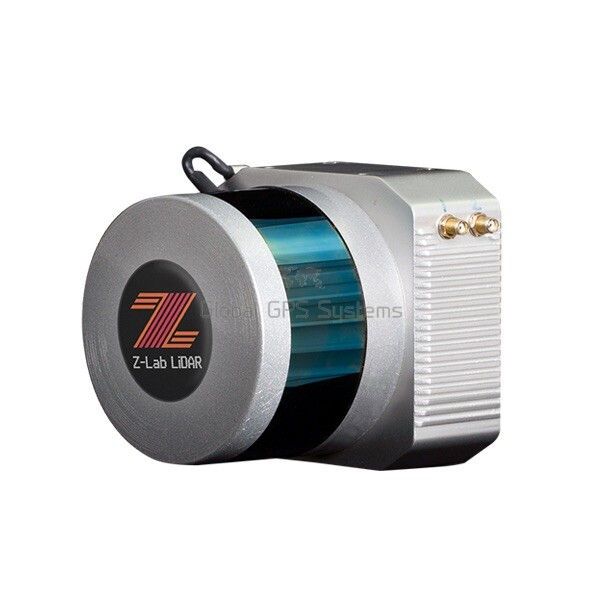
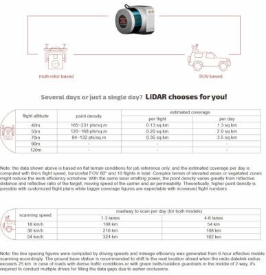
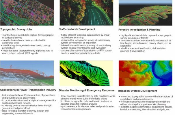
The SZT-V100 is a complete lidar system that is easy to carry, easy to install and easy to maintain. The system can be easily installed on multi-rotor drones such as the M600, or installed on an SUV which makes it a powerful mobile terrestrial scanning solution. Its most frequent applications are topographic surveys, traffic network development, forestry planning and research, electrical transmission networks, disaster monitoring and emergency response, and irrigation system development.
Valued customers:


Find RTK Networks
Search NTRIP providers and connect to reliable RTK correction services.
Description
Z-Lab LiDAR mobile laser scanning solutions
Specifications
| LiDAR System | Laser Channels | 16 channels |
| Laser Range | max. 100 m | |
| Field of View | +15.0° to -15.0° (30°) (Vertical); 360° (Horizontal) | |
| Angular Resolution | 2.0° (Vertical); 0.1° to 0.4° (Horizontal/Azimuth) | |
| Max. Means Rate | Single Return Mode: ~300,000 points per second Dual Return Mode: ~600,000 points per second |
|
| Accuracy | Relative Accuracy: 5 cm; Absolute Accuracy: 10 cm | |
| Camera Effective Pixels | 24.3 MP, RGB | |
| Recommended scanning height AGL | 10-80 m | |
| Net Weight | 1.5 kg (w/o camera) | |
| Dimensions | 116.5 x 112 x 123 mm | |
| Input Voltage | 11-18 V DC | |
| Power Consumption | 20 W | |
| Data Storage | 256 GB SSD | |
| Part I: Laser Scanner | Type | Velodyne VLP-16 |
| Wavelength | 903 nm | |
| Eye Safety Class | — | |
| Laser Product Classification | Class 1 Eye-safe-per IEC 60825-1:2007 & 2014 | |
| Laser Pulse Repetition Rate | — | |
| Range Accuracy | up to ±3 cm (typical) | |
| Accuracy/ Precision | — | |
| Rotation Rate | 5 Hz ~ 20 Hz | |
| Scan Speed | — | |
| Multi-echo effect | 2 echo returns | |
| Data Storage | — | |
| Environment Protection | IP67 | |
| Temperature | operating: -10℃~60℃; storage: -40℃~80℃ | |
| Part II: POS System | Type | Inertial Labs INS-D-OEM |
| Gyroscopes Bias in-run Stability | 1 deg/hr (RMS, Allan Variance) | |
| Gyroscopes Measurement Range | ±450 deg/sec | |
| Accelerometers Measurement Range | ±8 g | |
| Post Processing Roll/Pitch Accuracy | 0.006 deg RMS | |
| Post Processing Heading Accuracy | 0.03 deg RMS | |
| Post Processing Position H/V Accuracy | 0.005/0.01 meters, RMS | |
| Post Processing Velocity H/V Accuracy | 0.02/0.01 meters/sec, RMS | |
| Data Sampling Rate | IMU: 200 Hz, GNSS positions: 5 Hz | |
| Internal Memory | — |
Datasheets & Manuals
Datasheets and manuals
Datasheet
Reviews (0)
Only logged in customers who have purchased this product may leave a review.
Reviews
There are no reviews yet