

 GPS & GNSS
 Lidar scanning
 Total Station
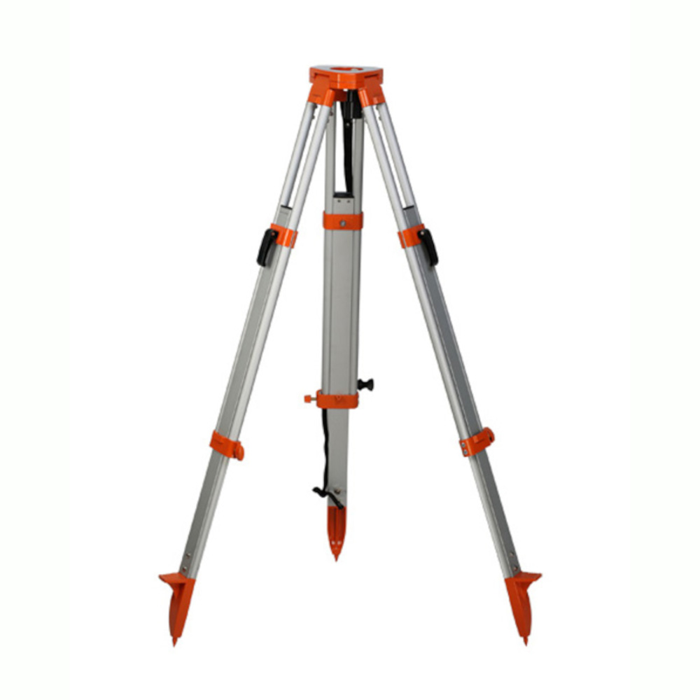
Surveying Tripod Aluminum
Get the best price for your setup
Contact our experts for the best possible price and configuration.
- Fast response
- Expert configuration advice
- No overpaying for features you do not need
The Kolida Surveying Tripod Aluminum provides a stable, practical base for field surveying equipment. Its aluminum construction offers a useful balance between strength and portability, making it suitable for surveyors, construction crews, engineers, GIS teams, and drone-mapping workflows that require reliable ground control. The tripod can be used to support compatible GNSS receivers, total stations, levels, and related surveying instruments during setup, measurement, layout, and positioning tasks. At 4.2 kg, it is substantial enough for regular site work while remaining manageable to transport between locations. It is a straightforward choice for professionals comparing dependable aluminum tripods for construction, land surveying, infrastructure, and geospatial fieldwork.
Kolida Surveying Tripod Aluminum Highlights
| Product type | Surveying tripod |
|---|---|
| Material | Aluminum |
| Weight | 4.2 kg |
| Brand | Kolida |
| Typical applications | GNSS, total station, level, construction, GIS, and land surveying work |
Valued customers:










Find RTK Networks
Search NTRIP providers and connect to reliable RTK correction services.
Description
Kolida Aluminum Surveying Tripod for Reliable Field Setups
The Kolida Aluminum Surveying Tripod provides a stable, practical platform for survey instruments used in construction, engineering, mapping, GNSS positioning, and general site measurement. Designed for professional fieldwork, this tripod helps keep mounted equipment steady while measurements are taken, reducing the risk of movement caused by vibration, uneven ground, or frequent repositioning on busy job sites.
With a listed weight of approximately 4.2 kg, the tripod offers a useful balance between portability and stability. It is light enough for surveyors, construction crews, GIS technicians, drone mapping teams, and engineers to carry between measurement points, while still providing the solid support expected from a professional surveying tripod. The aluminum construction is well suited to outdoor work because it is durable, relatively lightweight, and suitable for repeated setup and teardown in changing field conditions.
Stable support for surveying and GNSS equipment
A tripod is more than a simple stand when working with precision equipment. Any movement at the instrument can affect the quality of observations, especially when using a total station, optical level, laser level, theodolite, GNSS base receiver, or other surveying accessory. The Kolida Aluminum Surveying Tripod creates a firm foundation so the instrument can remain in position while the operator completes a measurement, checks a point, establishes a reference, or carries out construction layout work.
For GNSS users, the tripod can be used as part of a base station or control-point setup when paired with the appropriate tribrach, adapter, or mounting hardware. A stable base helps the receiver remain over the intended point and reduces the chance of accidental movement during initialization, correction transmission, or longer observation sessions. The tripod can also support related surveying equipment when the mounting configuration matches the instrument being used.
Aluminum construction for everyday field use
The aluminum frame is designed for users who need dependable equipment without the additional weight associated with heavier tripod materials. Aluminum is commonly chosen for general surveying because it provides a practical combination of strength, portability, and resistance to outdoor wear. This makes the tripod suitable for transport in a survey vehicle, movement around construction sites, and repeated use on road, utility, building, infrastructure, and land development projects.
Its construction is appropriate for professional users who may need to work on compacted soil, gravel, concrete, asphalt, grass, or other typical job-site surfaces. As with any surveying tripod, the best results come from placing the feet on stable ground, spreading the legs evenly, securing the leg locks, and checking the instrument level before taking measurements.
Adjustable setup for uneven terrain
Surveying rarely takes place on perfectly level ground. Sloped terrain, rough surfaces, excavation areas, curbs, embankments, and temporary work zones can all make equipment setup more difficult. The three-leg design allows the operator to adjust the tripod position and leg extension so the instrument can be brought into a suitable working position. This is especially useful when moving between different points throughout a site.
Correct setup remains important for accuracy. The tripod should be opened on firm ground, with each leg locked securely before the instrument is attached. On soft or loose soil, the feet should be pressed firmly into the surface where appropriate. On hard surfaces, the operator should make sure the tripod does not slide or sit on debris. Once the instrument is mounted, the setup should be checked again after final leveling and before recording measurements.
Suitable for surveyors, contractors, engineers, and GIS teams
The Kolida Aluminum Surveying Tripod is suited to a wide range of field users. Land surveyors can use it to support equipment during boundary, topographic, construction, and control surveys. Civil engineers and site technicians can use it for alignment checks, elevation work, point verification, and infrastructure measurements. Construction professionals can include it in workflows involving building layout, grading, drainage, foundation checks, roadwork, and utility installation.
GIS and mapping teams can use the tripod as part of a ground-control or reference-point setup when collecting accurate field data to support mapping projects. Drone pilots and aerial mapping operators may also use a stable tripod with a GNSS receiver or survey accessory when establishing ground-control points, setting up a base receiver, or checking the position of mapped features. In each case, the tripod supports the measurement workflow but does not replace the need for correct instrument setup, calibration, site procedures, and suitable correction services.
Practical portability between job sites
At approximately 4.2 kg, this tripod is intended for users who need a field-ready support system that can be carried and repositioned without excessive effort. It can be transported with other surveying equipment and set up as work progresses across a site. This is useful for crews that move frequently between observation points, work in large open areas, or need to switch between construction phases during the day.
The aluminum design also makes the tripod a practical choice for organizations managing multiple crews or equipment kits. It can serve as a general-purpose tripod for compatible surveying instruments, helping teams maintain a consistent setup method across different projects. Before ordering, users should confirm that the tripod head and mounting arrangement are suitable for the specific receiver, total station, level, tribrach, or adapter they plan to use.
Built for repeatable surveying workflows
Professional field measurements often depend on repeatable procedures. The same equipment may be set up and packed away many times in a single day. A suitable tripod should therefore be straightforward to position, secure, adjust, and transport. The Kolida Aluminum Surveying Tripod is designed for this type of regular use, giving field crews a dependable support platform for standard surveying and construction tasks.
For best performance, keep the leg locks clean and secure, inspect the feet and mounting hardware regularly, and avoid carrying the tripod by a mounted instrument. When working in windy conditions or around moving machinery, choose the most protected practical location and confirm that the tripod remains stable before collecting data. These simple habits help protect both the tripod and the precision instrument installed on it.
A practical foundation for accurate field equipment
The value of a surveying tripod is measured by how consistently it supports the instrument during real work. The Kolida Aluminum Surveying Tripod is a practical option for professionals who need stable equipment support, manageable transport weight, and a durable aluminum construction for routine outdoor use. It is suitable for general surveying, GNSS positioning, construction layout, engineering measurements, GIS fieldwork, and related applications where a secure instrument foundation is required.
Because surveying instruments vary in mounting style, users should confirm the required head type, thread, tribrach, adapter, and instrument weight before finalizing a setup. The team at Global GPS Systems can help buyers match the tripod with compatible GNSS receivers, total stations, levels, poles, tribrachs, and field accessories. This is particularly useful for contractors and survey crews comparing complete equipment setups rather than purchasing a tripod in isolation.
Choose the Kolida Aluminum Surveying Tripod when you need a dependable, portable support system for professional measurement work across construction sites, land surveys, infrastructure projects, mapping operations, and other accuracy-focused field environments.
Specifications
Kolida ATS-JP2 Specifications
Product Identification
| Product type | Professional surveying tripod |
|---|---|
| Listed brand | Kolida |
| Associated model | ATS-JP2 aluminum tripod |
| Associated part reference | M1N-JP2-A300-27 |
| Primary use | Support for surveying and measurement instruments |
| Intended users | Land surveyors, civil engineers, construction professionals, mapping technicians, GIS specialists, mining surveyors and infrastructure teams |
Construction and Design
| Construction material | Aluminum |
|---|---|
| Construction type | Heavy-duty professional construction |
| Leg design | Round aluminum legs |
| Tripod head type | Flat head |
| Leg locking system | Twist-lock system |
| Stability design | Three-leg support platform designed for stable instrument setup on surveying sites |
| Environmental material benefit | Aluminum construction is resistant to shrinking and swelling compared with traditional wood tripod materials |
Dimensions and Weight
| Minimum or closed length | 1,030 mm (103 cm) |
|---|---|
| Full or opened length | 1,655 mm (165.5 cm) |
| Maximum listed opened length | Approximately 1,650–1,710 mm, depending on the referenced configuration |
| Tripod head outer diameter | 160 mm |
| Tripod head inner diameter | 67.5 mm |
| Product weight listed on product page | 4.2 kg |
| Manufacturer-reference weight | Approximately 4.0 kg for the ATS-JP2 configuration; some listings specify 4.2 kg |
Mounting and Compatibility
| Tripod mounting thread | 5/8 in M16 surveying instrument thread |
|---|---|
| Supported equipment type | Surveying GNSS and GPS receivers, total stations, theodolites, automatic levels, digital levels, optical levels and other compatible measurement instruments |
| Mounting interface | Flat surveying tripod head |
| Instrument compatibility | Compatible when the instrument or tribrach uses a matching 5/8 in M16 tripod connection |
| Head configuration | Flat head with approximately 160 mm outer diameter and 67.5 mm inner diameter |
Functional Features
| Height adjustment | Adjustable through telescoping tripod legs |
|---|---|
| Leg adjustment range | Approximately 625 mm between the listed minimum and full lengths |
| Lock operation | Twist-lock leg adjustment |
| Clamp option | Some related configurations are available with a wing-nut clamp or quick-release clamp; verify the supplied configuration before ordering |
| Carrying provision | Carrying straps may be included or available depending on configuration |
| Decorative chain | Decorative chain may be available as an optional accessory for JP-series tripod configurations |
| Portable design | Folding three-leg design for transport and field deployment |
Typical Applications and Industries
| Surveying and mapping | Boundary surveys, topographic surveys, control-point establishment, cadastral work and field mapping |
|---|---|
| Construction and engineering | Site layout, grading, alignment, elevation checks, as-built surveys and infrastructure positioning |
| Mining and quarrying | Stockpile measurement, site control, excavation layout and mine surveying |
| GIS and asset mapping | Field data collection, utility mapping, asset inventory and geospatial control work |
| Urban planning and land management | Property measurement, municipal mapping, development planning and land administration |
| Precision instrument support | Provides a stable mounting platform for compatible GNSS receivers, total stations, levels and theodolites |
Package and Included Items
| Item | Quantity | Notes |
|---|---|---|
| Aluminum surveying tripod | 1 | Tripod configuration supplied may vary by manufacturer or distributor |
| Carrying strap | Configuration dependent | May be included with selected versions |
| Decorative chain | Optional | Availability depends on the JP-series configuration |
| Instrument or tribrach | Not specified | Typically purchased separately unless included in a configured equipment package |
| Tripod case | Not specified | Confirm whether a carrying case is included with the selected configuration |
Configuration Notes
| Weight variation | Published references identify the ATS-JP2 configuration at approximately 4.0 kg to 4.2 kg |
|---|---|
| Dimension variation | Published references identify the full length at approximately 1,650 mm to 1,655 mm; some distributor descriptions list up to 1,710 mm opened length |
| Clamp variation | Twist-lock, wing-nut clamp and quick-release clamp configurations may be available across related aluminum tripod variants |
| Instrument requirement | Confirm that the instrument or tribrach uses the required 5/8 in M16 connection and is suitable for a flat-head surveying tripod |
| Datasheet or manual availability | No dedicated operating manual was identified for the individual Global GPS Systems listing; the available technical information is primarily dimensional and configuration-based |
Specifications and package contents may vary by configuration, region or manufacturer update. Always check the current configuration before ordering.
Additional information
| Weight | 4.2 kg |
|---|
Reviews (1)
1 review for Surveying Tripod Aluminum
Only logged in customers who have purchased this product may leave a review.
FAQ
Aluminum Survey Tripod FAQ
Product Overview and Specifications
What is the Aluminum Surveying Tripod used for?
The Aluminum Surveying Tripod provides a stable platform for compatible surveying instruments and accessories, including GNSS receivers, total stations, prisms, levels, and other field measurement equipment.
What material is the tripod made from?
This surveying tripod is made from aluminum, providing a practical balance between strength, portability, and weight for everyday fieldwork.
How much does the Aluminum Surveying Tripod weigh?
The product weight listed by Global GPS Systems is 4.2 kg.
Is this tripod suitable for professional surveying work?
It is designed for surveying applications and can be used by professionals who need a stable tripod for compatible field instruments. Always check the instrument’s mounting requirements and recommended tripod specifications before use.
Are the tripod dimensions and maximum load capacity specified?
The product page lists the tripod weight but does not specify its folded length, operating height range, head dimensions, or maximum load capacity. Contact Global GPS Systems to confirm these details for your instrument.
Compatibility and Instrument Setup
Which instruments can be mounted on this surveying tripod?
The tripod may be used with compatible GNSS receivers, total stations, optical instruments, prisms, automatic levels, digital levels, and other surveying equipment. Compatibility depends on the instrument connection, tribrach, adapter, and mounting thread.
Is a tribrach or adapter included?
The product page identifies the item as an Aluminum Surveying Tripod but does not state that a tribrach, adapter, mounting screw, or other accessory is included. Confirm the package contents before ordering.
Does the tripod have a standard 5/8-inch surveying connection?
The product page does not specify the mounting thread or connector. Many surveying instruments use a 5/8-inch connection, but you should verify the required thread and adapter with Global GPS Systems before purchase.
Can I use this tripod with a GNSS base station?
A surveying tripod can be used for a GNSS base station when the receiver, antenna, tribrach, and adapter are compatible. The tripod should be positioned securely over the control point and carefully leveled for accurate results.
Can I use this tripod with a total station?
It may be suitable for a compatible total station, provided the mounting connection and stability requirements match the instrument. For motorized or high-precision total station work, confirm that the tripod meets the manufacturer’s stability recommendations.
Field Use and Surveying Applications
Who typically uses an aluminum surveying tripod?
Typical users include land surveyors, construction surveyors, civil engineers, geospatial professionals, utility crews, mapping teams, contractors, site layout technicians, and field technicians working with positioning or measurement equipment.
Which industries use this type of tripod?
Common industries include land surveying, construction, civil engineering, infrastructure, road and rail development, utilities, mining, agriculture, forestry, mapping, GIS data collection, and environmental fieldwork.
What surveying tasks can be performed with this tripod?
Depending on the mounted instrument, the tripod can support tasks such as boundary surveying, topographic surveying, construction layout, staking out, control point observations, site measurement, elevation checks, as-built surveys, mapping, and GNSS base station setup.
Why is tripod stability important in surveying?
A stable tripod helps keep the instrument centered, level, and less affected by movement or vibration. This supports more consistent measurements and reduces the risk of errors caused by an unstable setup.
Is aluminum a good material for a surveying tripod?
Aluminum tripods are commonly chosen because they are durable, relatively lightweight, and practical for mobile fieldwork. The best material depends on the instrument, accuracy requirements, environmental conditions, and length of the setup.
Setup, Care, and Buying Questions
How do I set up the Aluminum Surveying Tripod?
Place the tripod on firm ground, spread the legs evenly, adjust the leg length, and tighten the leg locks securely. Level the tripod head as accurately as possible, attach the compatible tribrach or adapter, mount the instrument, and check that the complete setup is stable before measuring.
How can I improve tripod stability in the field?
Use firm and level ground where possible, spread the legs wide, extend the thicker leg sections first, avoid placing a foot on loose soil or unstable surfaces, tighten the locks evenly, and avoid touching or leaning on the tripod during measurements.
Can the tripod be used outdoors in changing weather?
The tripod is intended for field surveying, but the product page does not specify an IP rating or weather-resistance classification. Protect it from prolonged exposure to rain, mud, salt, and corrosive materials, and dry it thoroughly after use.
How should I maintain the tripod?
Keep the leg sections, locks, hinges, and mounting head clean. Remove dirt and grit after fieldwork, inspect the leg locks and mounting connection regularly, and store the tripod dry and protected from impact when it is not in use.
What should I check before ordering this tripod?
Confirm the instrument’s mounting thread, tribrach or adapter requirements, required load capacity, operating height, folded transport size, and the stability level needed for your application. If any specification is not listed, contact Global GPS Systems for confirmation.
 GPS & GNSS
 Total Stations
 Data collectors
 Software
 Correction services
 Machine control
 External radio
 Marine
 Accessories
Robert Stopar (verified owner) –
Good tripod.