


 GPS & GNSS
 Lidar scanning
 Total Station
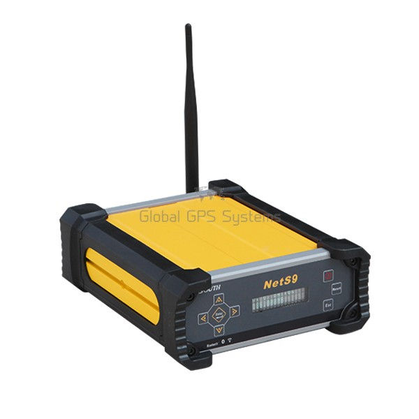
South NET S9 CORS GNSS Base Station 336 Channel IP67
Get the best price for your setup
Contact our experts for the best possible price and configuration.
- Fast response
- Expert configuration advice
- No overpaying for features you do not need
The South NET S9 is a continuously operating GNSS reference station receiver for CORS networks, permanent base stations, and high-accuracy surveying infrastructure. Its 336-channel GNSS engine tracks GPS, GLONASS, BeiDou, Galileo, and SBAS signals for dependable positioning and correction data. Built-in WiFi, Bluetooth, Ethernet, NTRIP, and serial connectivity make it practical to configure remotely and distribute corrections to field crews, construction teams, GIS users, and drone mapping workflows. The receiver stores STH and RINEX data, supports FTP transfer, and includes 32GB eMMC memory with up to 1TB external USB storage. A 10,000mAh backup battery, IP67 housing, and wide operating temperature range support continuous use in demanding outdoor environments.
South NET S9 Highlights
| GNSS tracking | 336 channels; GPS, GLONASS, BeiDou, Galileo and SBAS |
|---|---|
| Reference station use | CORS, permanent base stations and GNSS correction services |
| Data and networking | NTRIP, TCP/IP, Ethernet, WiFi, Bluetooth and serial communication |
| Storage | 32GB eMMC memory; supports STH, RINEX2.x and RINEX3.x files |
| Power and protection | 10,000mAh backup battery; IP67 aluminum housing |
Valued customers:










Find RTK Networks
Search NTRIP providers and connect to reliable RTK correction services.
Description
South Net S9 for Reliable GNSS Infrastructure
The South Net S9 is a professional GNSS reference station receiver designed for continuously operating base stations, CORS networks, surveying infrastructure, and applications that depend on a stable source of accurate satellite positioning data. It is built for organizations and field teams that need more than a portable RTK rover. Instead of being carried from point to point, the South Net S9 is installed at a known, carefully surveyed location and used to collect GNSS observations, store raw satellite data, and provide correction data to compatible surveying, mapping, engineering, and monitoring systems.
With a 336-channel GNSS board and support for multiple satellite constellations, the South Net S9 can track signals from GPS, GLONASS, BeiDou, Galileo, and SBAS systems. Tracking signals from several constellations helps the receiver maintain a stronger and more reliable satellite solution, particularly in areas where the sky view is partially obstructed by buildings, terrain, trees, or infrastructure. In practical fieldwork, this makes the receiver well suited to permanent or semi-permanent installations where dependable data collection is more important than a compact rover form factor.
Designed for CORS, base station, and monitoring applications
The South Net S9 is primarily a GNSS base receiver for reference station work. It can be used as part of a local RTK base and rover setup, a continuously operating reference station, a networked CORS installation, or a GNSS data collection system for post-processing and surveying control. When connected to a suitable GNSS antenna and installed over a known point, the receiver can collect observation data and transmit corrections through a connected network.
This type of equipment is commonly used by land surveyors, civil engineering companies, construction contractors, mapping professionals, GIS departments, infrastructure operators, deformation monitoring teams, and organizations maintaining local positioning services. It can support workflows such as construction control, cadastral surveying, topographic mapping, machine positioning, corridor surveys, asset mapping, site monitoring, and the creation or operation of a local GNSS reference network.
For construction and engineering teams, the South Net S9 can provide a dependable correction source for RTK rovers working across a site or project area. For surveying offices, it can help create a fixed reference station that supports repeated measurements and consistent project control. For GIS and mapping users, the receiver can provide raw observation files and navigation data that can be integrated into processing and quality-control workflows. In monitoring applications, the fixed installation can continuously observe the reference point and forward data to software or network services designed to evaluate movement over time.
336-channel GNSS tracking for dependable satellite coverage
The 336-channel GNSS engine is designed to track a broad range of signals across the major global navigation satellite systems. The South Net S9 supports GPS, GLONASS, BeiDou, Galileo, and SBAS signals, giving the receiver access to a large pool of satellites instead of relying on a single constellation. This is especially useful for reference stations operating over long periods, because satellite availability and geometry change throughout the day.
In real-world surveying, a larger multi-constellation view can help reduce interruptions caused by limited satellite visibility. It can also improve the availability of usable observations in challenging locations, although final performance still depends on antenna quality, installation, multipath, atmospheric conditions, satellite geometry, and the accuracy of the reference coordinates. The receiver should therefore be installed in an open, stable location with a suitable geodetic antenna and a properly measured antenna height.
The South Net S9 supports positioning, static GNSS surveying, real-time kinematic workflows, network RTK, differential GNSS, and reference station data generation. The receiver itself is intended to serve as the fixed source of GNSS observations or corrections; the final accuracy achieved by a rover or monitoring system will depend on the complete setup, including the antenna, correction link, rover equipment, field software, and survey procedures.
Flexible data storage and output
A reference station may need to run for long periods without frequent operator visits. The South Net S9 is designed with internal eMMC storage and supports cycle recording of raw GNSS data. This gives operators a practical way to retain observation files for post-processing, quality checks, troubleshooting, or later project documentation.
The receiver supports STH and RINEX raw data storage, allowing users to select a format that fits their existing processing and archiving workflow. RINEX compatibility is particularly useful when observation files need to be used with third-party GNSS processing software, scientific applications, network services, or long-term surveying records. The receiver can also support data retrieval through HTTP, FTP, and USB transfer, making it easier to access files locally or through a connected network.
External USB storage can be used when additional capacity is needed. The receiver supports external storage devices up to 1 TB, which can be useful for installations that record continuously, maintain several recording intervals, or retain data for extended periods. Automatic cycle recording helps manage storage during ongoing operation, but users should still establish a sensible file-retention and backup procedure for important survey and monitoring data.
Network communication for connected reference stations
The South Net S9 includes network communication functions intended for modern GNSS reference station workflows. It supports Ethernet connections through RJ45 interfaces and can work with TCP/IP, HTTP, and NTRIP-based data services. Depending on the installation, the receiver can be configured as an NTRIP client, NTRIP server, or part of an NTRIP caster arrangement. It also supports TCP client and TCP server functions for users working with other correction-data or data-transfer systems.
This flexibility allows the receiver to be integrated into different network designs. A survey company may use it to send correction data to field rovers over an NTRIP service. A network operator may connect the receiver to a CORS management system. An engineering or monitoring team may configure it to forward raw observations to a central server for storage and analysis. The correct configuration will depend on the network architecture, available internet service, firewall settings, port mapping, and the software used to distribute or process the data.
For sites where direct cabling is inconvenient, the built-in Wi-Fi hotspot provides a practical way to connect a laptop, tablet, or mobile device to the receiver for setup and administration. Bluetooth connectivity is also available for short-range wireless communication. These connections can simplify commissioning and maintenance by reducing the need to connect directly through a serial cable whenever a configuration change is required.
Web-based configuration and local controls
The South Net S9 can be configured through its front-panel controls, serial interface, Wi-Fi connection, Bluetooth connection, or built-in web server. The web-based interface gives operators access to receiver status, satellite information, reference station settings, antenna parameters, data recording, data transfer, network configuration, firmware management, and user administration.
This is useful for permanent installations because many routine tasks can be completed without physically accessing every control on the receiver. Operators can check system status, review satellite tracking information, confirm the receiver position, manage recording settings, and configure network services from a connected computer or mobile terminal. The front display and buttons remain useful for local checks, startup, and basic configuration when a network connection is not yet available.
For remote or unattended installations, proper access control and network security should be part of the setup. Passwords should be changed from their initial settings, unused services should be disabled where appropriate, and remote access should be limited to authorized users and networks. These practices help protect the receiver configuration and reduce the risk of interruptions to a correction or monitoring service.
Power backup for continuous operation
The South Net S9 has a built-in 10,000 mAh battery that can operate as a primary power source or as an uninterruptible power supply backup. When external power is available, the receiver can use that supply and charge the internal battery. If external power is interrupted, the battery can help keep the receiver operating and reduce the chance of data gaps or an immediate shutdown.
The receiver accepts a 9 V to 28 V DC input and is designed for low power consumption. In its default configuration, the internal battery is specified for more than 15 hours of continuous operation, although actual runtime can vary depending on communication activity, connected accessories, battery condition, temperature, and operating settings. For permanent reference stations, the internal battery should be viewed as a backup layer rather than a replacement for a properly designed mains, solar, or other primary power system.
Power continuity is important in RTK and monitoring work because even a short interruption can create gaps in correction streams or observation files. The South Net S9’s integrated backup battery provides additional time for operators to respond to an electrical problem, restore the primary supply, or safely manage the installation.
Rugged housing for demanding installation environments
The receiver uses an aluminum alloy housing with a rugged design intended for field and infrastructure installations. Its IP67 protection rating helps protect the unit against dust and temporary immersion in water up to the specified conditions. The housing is also designed to withstand shock and vibration, including a stated 2 m drop-to-concrete test condition.
This construction makes the South Net S9 suitable for equipment rooms, survey control points, infrastructure sites, utility locations, construction compounds, monitoring stations, and other environments where equipment may be exposed to dust, moisture, vibration, or changing temperatures. IP67 protection does not remove the need for correct installation. The antenna connection, power supply, network cables, mounting arrangement, and enclosure ventilation should all be planned carefully, especially where the receiver is installed outdoors or in an exposed location.
The receiver is specified for a working temperature range from -40°C to +75°C and a storage temperature range from -40°C to +80°C. It can operate in relative humidity conditions of up to 95 percent. As with any high-accuracy GNSS system, the installation environment still matters. A protected, stable location with a clear view of the sky will generally provide better data quality than a location surrounded by reflective surfaces or physical obstructions.
Practical applications for surveyors, engineers, and GIS teams
The South Net S9 can be a useful choice when a project needs a fixed GNSS reference rather than a handheld receiver. Typical applications include local RTK base stations for construction sites, CORS network stations, survey control and topographic mapping, cadastral and land administration projects, deformation and structural monitoring, road and railway corridor surveys, utility and infrastructure mapping, GIS data collection support, and GNSS observation recording for post-processing.
On a construction project, the receiver can support rover crews who need consistent corrections for setting out, checking elevations, collecting as-built data, or locating site assets. In civil engineering, it can form part of a positioning system for roads, bridges, earthworks, and large infrastructure projects. In surveying offices, it can provide a repeatable reference point for projects that extend over multiple days or require several field teams to work from the same correction source.
GIS professionals can use the receiver as a reliable source of observation and correction data when mapping roads, utilities, property features, environmental assets, or other spatial information. Drone pilots and UAV mapping teams may also benefit from a local GNSS reference station when their aerial mapping workflow requires accurate ground control, correction data, or a stable project reference. The South Net S9 is not a drone autopilot or airborne positioning unit, but it can support the ground-based GNSS infrastructure used alongside photogrammetry and mapping operations.
What to consider before choosing the South Net S9
The South Net S9 is best suited to users who need a fixed, network-capable GNSS reference receiver. It is not intended to replace a compact rover receiver for walking around a site, collecting points by hand, or carrying between jobs. A complete installation normally requires a compatible GNSS antenna, antenna cable, stable mounting or monument, accurately established coordinates, a suitable power arrangement, and a reliable network or correction-data service.
Before purchase, consider where the receiver will be installed, how correction data will reach field users, whether the project requires RINEX files for post-processing, how long the station must operate without maintenance, and whether the existing GNSS software supports the required formats and NTRIP configuration. Buyers should also confirm antenna compatibility, connector requirements, network access, mounting arrangements, and environmental protection for the complete system rather than evaluating the receiver in isolation.
Support from Global GPS Systems
Global GPS Systems can help buyers assess whether the South Net S9 fits their surveying, construction, GIS, monitoring, or CORS requirements. The most suitable configuration depends on the intended installation, antenna, correction-data workflow, power source, network design, and the field equipment that will connect to the station. If you are comparing RTK GNSS equipment or planning a permanent reference station, Global GPS Systems can provide practical guidance on configuration and compatibility before you commit to a setup.
For professional users who need dependable satellite tracking, flexible data communication, long-term observation storage, and backup power in a rugged reference receiver, the South Net S9 provides a capable foundation for GNSS infrastructure. Its combination of multi-constellation tracking, 336-channel processing, RINEX and STH data support, Ethernet, Wi-Fi, Bluetooth, NTRIP functionality, eMMC storage, and built-in battery backup makes it suitable for organizations that need accurate GNSS data to remain available across demanding surveying and positioning workflows.
Specifications
South S9 Specifications
Product Overview
| Product type | Continuously Operating Reference Station (CORS) GNSS receiver and professional GNSS base station |
|---|---|
| Model | NET S9 |
| Brand | SOUTH |
| Primary function | GNSS reference station operation, static data recording, differential correction output and network RTK support |
| GNSS engine | Integrated professional OEM GNSS board |
| Channel count | 336 channels |
| Supported satellite constellations | GPS, GLONASS, BeiDou, Galileo and SBAS |
| Typical applications | GNSS reference networks, CORS stations, surveying, mapping, geodesy, construction layout, infrastructure monitoring and precision positioning |
Typical Users and Industries
| Typical users | Land surveyors, geodesists, GNSS network operators, GIS professionals, civil engineering teams, construction contractors, infrastructure managers and research organizations |
|---|---|
| Surveying and mapping | Topographic surveying, cadastral surveying, boundary measurement, control-point establishment and geospatial data collection |
| Construction and infrastructure | Site positioning, machine-control support, road and rail construction, bridge work, utility projects and structural monitoring |
| Geodesy and reference networks | Permanent reference stations, regional CORS networks, GNSS data services and high-precision coordinate control |
| Monitoring applications | Deformation monitoring, settlement measurement, slope monitoring and long-term position tracking |
| Data service operations | Organizations that distribute RTCM corrections, NTRIP services, RINEX files or other GNSS reference data |
GNSS Tracking
| GPS signals | L1 C/A, L2E, L2C and L5 |
|---|---|
| GLONASS signals | L1 C/A, L1P, L2 C/A for GLONASS-M and L2P |
| BeiDou signals | B1, B2 and B3 |
| Galileo signals | E1, L1 BOC, E5A, E5B, E5AltBOC1 and E6 |
| SBAS signals | L1 C/A and L5 |
| Initialization time | Typically less than 10 seconds |
| Initialization reliability | Greater than 99.9% |
| Positioning rate | 1 Hz, 2 Hz, 5 Hz, 10 Hz, 20 Hz or 50 Hz, depending on the setup option |
Positioning Accuracy
| Positioning mode | Horizontal accuracy | Vertical accuracy |
|---|---|---|
| Code differential GNSS | 25 cm + 1 ppm RMS | 50 cm + 1 ppm RMS |
| SBAS positioning | Less than 5 m typical, 3DRMS RMS | |
| Static GNSS surveying | 3 mm + 1 ppm RMS | 5 mm + 1 ppm RMS |
| Real-time kinematic, baseline under 30 km | 10 mm + 1 ppm RMS | 20 mm + 1 ppm RMS |
| Network RTK | 8 mm + 0.5 ppm RMS | 15 mm + 0.5 ppm RMS |
Data Storage and File Support
| Internal storage | 32 GB internal memory using eMMC technology |
|---|---|
| Internal memory function | Cycle recording of raw GNSS data |
| External storage | USB Host support for external storage devices up to 1 TB |
| Supported raw data formats | STH, RINEX 2.x and RINEX 3.x |
| Data retrieval | HTTP download, FTP transfer and USB copy |
| Data transfer functions | Raw data transfer, differential correction data transmission and FTP server support |
| Storage technology | Embedded MultiMediaCard (eMMC) storage for stable and reliable internal data handling |
Correction and Navigation Output
| Reference correction formats | CMR, CMR+, RTCM 2.1, RTCM 2.2, RTCM 2.3, RTCM 3.0, RTCM 3.1, RTCM 3.2, sCMRx, RTCA and NOVATELX |
|---|---|
| Navigation output format | ASCII NMEA-0183 and binary output |
| Supported NMEA messages | GSV, AVR, RMC, HDT, VGK, ROT, GGK, GGA, GSA, ZDA, VTG, GST, PJT, PJK, BPQ, GLL, GRS and GBS |
| NTRIP support | Supported through the Ethernet and network communication functions |
| PPS timing | PPS output with UTC timing support |
| Event marker | External event marker input supported through the multi-function interface |
| External frequency input | External frequency scale port for connection to a high-precision atomic clock |
Communication and Networking
| Ethernet protocols | TCP/IP, HTTP and NTRIP |
|---|---|
| Ethernet interfaces | Two RJ45 100 Mb Ethernet interfaces |
| Wi-Fi | 2.4 GHz Wi-Fi, IEEE 802.11 b/g/n |
| Wi-Fi function | Integrated Wi-Fi hotspot for connecting mobile terminals and accessing the built-in web user interface |
| Bluetooth | Bluetooth 2.1, Class 2, with EDR, operating at 2.4 GHz |
| RS-232 | One 9-pin RS-232 serial port for data transmission |
| Remote configuration | Configuration through the front panel, LCD, Wi-Fi, web server, serial port or Bluetooth |
Electrical Specifications
| Input voltage | 9 V to 28 V DC |
|---|---|
| Power interfaces | Three separate power interfaces with over-voltage protection |
| Built-in battery | 10,000 mAh rechargeable battery |
| Battery function | Primary power source and uninterrupted power supply backup |
| Operating time | More than 15 hours of continuous operation in the default configuration |
| Power consumption | Approximately 3.8 W |
Interfaces and Controls
| Front panel | Front-panel display with buttons and LED screen |
|---|---|
| Control buttons | Eight front-panel buttons for power control, reset, navigation, configuration and confirmation functions |
| LCD display | Integrated display for receiver status, configuration and operating information |
| USB interfaces | Two USB ports consisting of one USB Host port and one USB Device port |
| Multi-function interface | Supports PPS output, event marker input, serial communication and power supply |
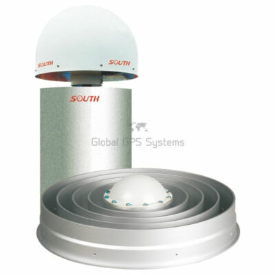
| GNSS antenna interface | Choke-ring antenna connection |
| Wi-Fi antenna interface | Connection for a Wi-Fi broadcast antenna |
| External frequency interface | Connection for an external frequency standard or high-precision atomic clock |
Software and Configuration Functions
| Built-in web server | Web-based receiver management and configuration interface |
|---|---|
| Receiver status monitoring | System information, work status, position information, temperature, voltage, battery status and available storage monitoring |
| Base station configuration | Base station coordinates, differential format, antenna settings and receiver operating parameters |
| Satellite configuration | Satellite system selection, signal selection and elevation mask-angle configuration |
| Data recording configuration | Static data collection interval and recording format configuration |
| Network configuration | Ethernet, Wi-Fi and network parameter configuration |
| Firmware management | Firmware update function through the receiver management interface |
| User management | Administrator and ordinary-user account management with different permission levels |
| Display languages | Chinese and English language options are supported in the user interface |
Physical Specifications
| Housing material | Rugged aluminum alloy housing with plastic ring seal |
|---|---|
| Dimensions | 216 mm × 178 mm × 72 mm |
| Weight | Approximately 2.28 kg |
| Shock resistance | Designed to withstand a drop of up to 2 m onto concrete |
| Dust protection | IP67-rated protection against dust ingress |
| Water protection | Protection against temporary immersion to a depth of 1 m |
Environmental Specifications
| Operating temperature | -40 °C to +75 °C |
|---|---|
| Storage temperature | -40 °C to +80 °C |
| Humidity | Relative humidity from 10% to 100%, including condensing conditions |
| Environmental design | Designed for continuous operation in demanding outdoor and industrial environments |
Package and Included Items
| Item | Quantity | Notes |
|---|---|---|
| NET S9 GNSS receiver | Not specified | Package contents depend on the selected configuration |
| GNSS antenna and cables | Not specified | Confirm antenna type, cable length and accessories before ordering |
| Power supply and connection accessories | Not specified | Included items may vary by regional or distributor configuration |
| Documentation | Not specified | User documentation and software access may vary by supply package |
Specifications and package contents may vary by configuration, region or manufacturer update. Always check the current configuration before ordering.
Reviews (0)
Only logged in customers who have purchased this product may leave a review.
FAQ
South S9 FAQ
Product Overview and Applications
What is the South NET S9?
The South NET S9 is a professional GNSS reference station receiver designed for CORS networks, permanent GNSS base stations, surveying infrastructure and high-accuracy positioning applications. It continuously tracks satellite signals, records raw observation data and can transmit correction or navigation data to connected systems.
What is the South NET S9 used for?
The receiver is used to establish a permanent or semi-permanent GNSS base station. Typical functions include collecting static observation data, generating differential corrections, supporting RTK and NTRIP workflows, transmitting reference data and providing a reliable GNSS reference for surveying or monitoring applications.
Is the South NET S9 a rover receiver?
The South NET S9 is primarily a GNSS base station and reference station receiver rather than a handheld rover. It can provide reference data and corrections to compatible rover receivers, survey controllers, machine-control systems or other positioning equipment.
Who should use the South NET S9?
The receiver is suitable for surveying companies, CORS network operators, geospatial service providers, civil engineering firms, construction companies, infrastructure managers, universities, mapping agencies, monitoring specialists and organizations that need continuous GNSS reference data.
Which industries use the South NET S9?
Common industries include land surveying, cadastral surveying, geodesy, construction, civil engineering, infrastructure development, transportation, deformation monitoring, land administration, utility mapping, route surveying, power-line inspection and precision positioning services.
Can the South NET S9 be used in a CORS network?
Yes. The South NET S9 is designed for continuously operating reference station applications. It can record GNSS observation data and transmit reference or correction data to servers, network software and connected users when correctly configured.
GNSS Performance and Data
How many GNSS channels does the South NET S9 have?
The product version listed on this page has a 336-channel professional GNSS board. Specifications can vary between production versions or regional configurations, so the exact channel configuration should be confirmed when ordering.
Which satellite constellations does the South NET S9 support?
The South NET S9 is designed to support the major global satellite navigation constellations, including GPS, GLONASS, BeiDou and Galileo. Depending on the installed board and firmware configuration, additional signals such as QZSS and SBAS may also be supported.
Can the South NET S9 record raw GNSS data?
Yes. The receiver can continuously record raw satellite observation data for post-processing, quality control, archiving and reference station operations. Recording parameters such as file format, interval and storage method can be configured.
Which data formats does the South NET S9 support?
The South NET S9 supports STH and RINEX raw data formats. It can also work with commonly used reference and navigation data formats, including RTCM, CMR, NMEA and other supported output formats depending on the configuration.
Can the South NET S9 transmit RTK correction data?
Yes. The receiver can be configured to transmit differential correction data for RTK workflows. Supported transmission methods and correction formats depend on the connected network, server, communication interface and software configuration.
Does the South NET S9 support NTRIP?
Yes. The receiver supports network-based GNSS data workflows, including NTRIP-related configurations. It can be used with suitable NTRIP servers, clients or correction-service infrastructure when the network settings and credentials are correctly configured.
Connectivity, Storage and Remote Management
How can the South NET S9 be configured?
The receiver can be configured through its front-panel buttons and display, web-based interface, Ethernet connection, Wi-Fi, Bluetooth and supported serial interfaces. This allows local technicians and remote administrators to manage the receiver according to the installation requirements.
Does the South NET S9 have Wi-Fi and Bluetooth?
Yes. Integrated Wi-Fi and Bluetooth connectivity allow users to configure and monitor the receiver from a compatible computer, tablet, smartphone or other mobile terminal, depending on the connection method and software used.
Can the South NET S9 be connected to a wired network?
Yes. The receiver includes Ethernet connectivity through RJ45 interfaces. A wired network connection can be used for web configuration, data transmission, server communication and reference station network integration.
How much internal storage does the South NET S9 have?
The South NET S9 uses high-speed eMMC internal storage. The product information lists internal memory for long-term recording and supports external USB storage expansion of up to 1 TB, subject to the storage device and configuration used.
Can recorded data be downloaded remotely?
Yes. Recorded data can be retrieved through supported network methods such as HTTP or FTP, and it can also be copied through USB. Remote retrieval is useful for CORS operators who need to access observation files without visiting the reference station.
Can the South NET S9 be managed remotely?
Yes. Remote management functions can include checking receiver status, changing configuration, restarting the receiver, managing stored data, registering the receiver and upgrading firmware. Remote access depends on the network setup, access permissions and supporting software.
Power, Installation and Environmental Protection
How long can the South NET S9 operate on its battery?
The South NET S9 has a built-in 10,000 mAh battery that can provide more than 15 hours of operation in the manufacturer’s stated default configuration. Actual operating time depends on communication activity, temperature, battery condition and connected accessories.
Can the South NET S9 act as a UPS?
Yes. The built-in battery can serve as a backup power source. If the external power supply fails, the receiver can automatically switch to battery operation. When external power is restored, it can switch back and recharge the internal battery.
What external power supply does the South NET S9 require?
The receiver supports a 9 V to 28 V DC input range. The power supply must be suitable for the installation and must not exceed the specified voltage range. Professional installation should include appropriate protection against surges, moisture and unstable power.
Is the South NET S9 waterproof and dustproof?
The South NET S9 has an IP67-rated industrial housing according to the product page. This provides protection against dust and temporary immersion in water under the conditions defined by the IP67 standard. All connectors, cable glands and antenna connections should still be installed correctly.
Can the South NET S9 operate in extreme temperatures?
The receiver is designed for demanding outdoor and industrial environments. The manufacturer’s documentation specifies an operating temperature range of approximately -40 °C to 75 °C. Actual performance also depends on solar exposure, enclosure design, ventilation and the surrounding installation conditions.
What interfaces are available on the South NET S9?
Depending on the product configuration, interfaces include GNSS antenna connection, Ethernet, RS-232 serial communication, USB, power inputs, Wi-Fi antenna connection, external frequency input, PPS output and event input. These interfaces support data transmission, timing, monitoring and reference station integration.
Does the South NET S9 support an external clock or timing reference?
Yes. The receiver includes an external frequency input for connection to a high-precision frequency or timing reference. It also provides a PPS output for applications that require synchronized timing, subject to the correct configuration and compatible external equipment.
Can the South NET S9 automatically restart after a power failure?
Yes. The receiver is designed to restart automatically after power is restored and retain its configured parameters. This is especially useful for unattended CORS stations, remote monitoring locations and installations where frequent on-site access is impractical.
What should be considered when installing the South NET S9?
Install the receiver in a stable, secure location with a suitable GNSS antenna, clear sky visibility, reliable power, appropriate grounding and dependable network connectivity. The antenna monument, antenna height, reference coordinates, cable routing and protection from interference should be carefully planned.
Does the South NET S9 include a GNSS antenna or complete reference station system?
The South NET S9 is the receiver component of a reference station system. Antennas, mounts, cables, network equipment, servers, correction software and other accessories may depend on the selected configuration. Confirm the complete package contents before purchase.
 GPS & GNSS
 Total Stations
 Data collectors
 Software
 Correction services
 Machine control
 External radio
 Marine
 Accessories
Reviews
There are no reviews yet