


 GPS & GNSS
 Lidar scanning
 Total Station
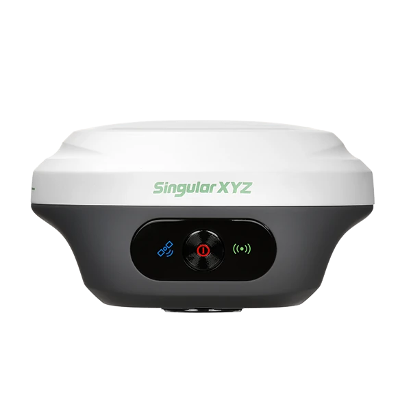



SingularXYZ Orion ONE AR Visual Stakeout RTK GNSS Receiver
Get the best price for your setup
Contact our experts for the best possible price and configuration.
- Fast response
- Expert configuration advice
- No overpaying for features you do not need
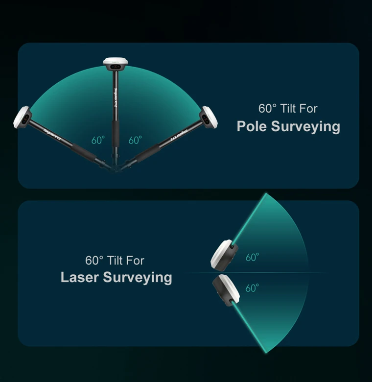
The Singular XYZ Orion One AR is a compact visual RTK GNSS receiver designed for surveying, construction setting-out, GIS data collection and other precision positioning work. Its integrated camera adds augmented-reality guidance to stakeout, helping the operator see the direction of the target point directly in the field. A calibration-free IMU supports measurements with the pole tilted by up to 60°, making it easier to survey points beside walls, beneath obstacles and in other locations where keeping the pole vertical is difficult.
With 1,408 channels and support for GPS, GLONASS, Galileo, BeiDou, QZSS, NavIC and SBAS signals, the receiver is built for dependable satellite tracking across varied working environments. The lightweight magnesium-aluminium housing, IP67 protection, internal UHF radio and up to 12-hour battery make it suitable for everyday field use.
Singular XYZ Orion One AR Highlights
| Visual stakeout | AR guidance through a 2 MP starlight-grade global-shutter camera |
|---|---|
| IMU tilt surveying | Up to 60° with stated accuracy better than ±2.5 cm |
| RTK accuracy | 8 mm + 1 ppm horizontal and 15 mm + 1 ppm vertical |
| Satellite tracking | 1,408 channels with GPS, GLONASS, Galileo, BeiDou, QZSS, NavIC and SBAS |
| Field protection | IP67 housing designed to survive a 2 m drop onto concrete |
| Internal radio | 410–470 MHz UHF with a stated range of up to 15 km in optimal conditions |
| Battery life | Up to 12 hours with approximately 3-hour fast charging |


Valued customers:










Find RTK Networks
Search NTRIP providers and connect to reliable RTK correction services.
Description
Compact visual RTK GNSS for faster field positioning
The Singular XYZ Orion One AR combines centimetre-level RTK GNSS positioning, IMU tilt compensation and camera-guided stakeout in a compact receiver weighing approximately 547 g. It is intended for surveyors, site engineers, construction teams, utility contractors, GIS professionals and other users who need to measure or set out accurate coordinates without carrying a large receiver.
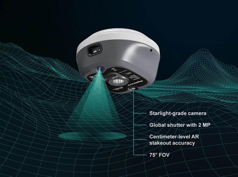
Its visual stakeout function uses a built-in camera and augmented-reality guidance to show the operator where the target point lies. Instead of relying only on arrows, distances and a plan view on the controller, the user can follow an on-screen indication placed over the live camera image. This can make it easier to approach points during building layout, roadworks, utility installation, boundary work and general topographic surveying.
AR stakeout with a low-light camera
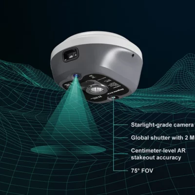
The receiver includes a 2 MP global-shutter camera with a 75° field of view and a frame rate of 30 fps. The starlight-grade sensor is designed to retain a clear image in weaker light, supporting stakeout work in shaded areas, around structures or during early and late working hours.
Visual guidance is especially useful when the target point is not obvious from the surroundings. Construction workers can use it to find footing, column, kerb or service positions, while surveyors can use it to navigate efficiently between multiple stakeout points. The manufacturer states an AR stakeout accuracy of 8 mm + 1 ppm horizontally and 15 mm + 1 ppm vertically under suitable operating conditions.
Measure without keeping the pole perfectly vertical
An integrated IMU allows the Orion One AR to measure with the survey pole tilted by up to 60°. This is useful when a point is close to a wall, beneath vegetation, beside parked equipment or in another location where the receiver cannot be held directly above the point.
Tilt compensation reduces the time spent levelling the pole for every observation and helps operators maintain a more natural working position. Within the stated tilt range, the specified tilt-surveying accuracy is better than ±2.5 cm. Actual results will still depend on satellite conditions, correction quality, pole setup and normal field practice.
Full-constellation satellite tracking
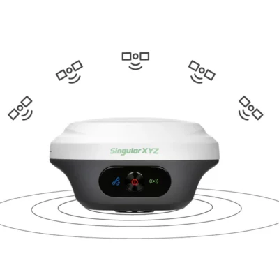
The 1,408-channel GNSS board tracks signals from GPS, GLONASS, Galileo, BeiDou, QZSS and NavIC, together with supported SBAS services. Access to multiple constellations and frequencies gives the receiver more observations to work with, helping it maintain positioning performance when parts of the sky are obstructed.
This is valuable on construction sites, beside buildings, near trees and in other environments where satellite visibility changes as the operator moves. Typical RTK initialisation is stated as under five seconds, with a stated initialisation reliability above 99.9% in suitable conditions.
RTK rover, base and static survey workflows
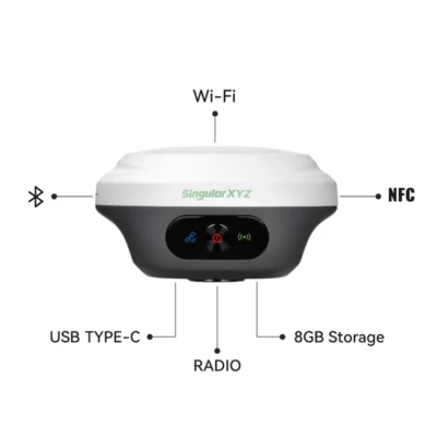
The Orion One AR can be used with network corrections through a connected controller or configured for radio-based work. Supported communication methods include Bluetooth, Wi-Fi, NFC, USB Type-C and an internal 410–470 MHz UHF modem. NTRIP client, NTRIP server, NTRIP caster, TCP and UDP protocols are supported.
The internal UHF radio has a stated working range of up to 15 km in optimal conditions, although practical range depends on terrain, antenna height, interference, radio settings and local regulations. Enhanced LoRa and standard UHF configurations may differ in compatibility, so the required base-and-rover setup should be confirmed before ordering.
For static surveying and post-processing, the receiver provides 8 GB of internal storage and supports RINEX 3.02 and 3.04 data. Storage may be expandable depending on the selected configuration. A Wi-Fi-accessible web interface allows users to review receiver status, change settings, transfer files, manage stored data and perform system updates.
Built for daily work outdoors
The receiver measures approximately 107 mm in diameter and 58.7 mm in height. Its magnesium-aluminium alloy housing keeps the unit compact while providing protection for regular field use. The enclosure is rated IP67 against dust and water ingress and is designed to withstand a 2 m drop onto concrete.
The specified operating temperature range is −40°C to +65°C. A 4,200 mAh internal battery provides up to 12 hours of working time, depending on the active operating mode, with a stated charging time of about three hours. These characteristics make the unit suitable for full working days in surveying, civil engineering, construction and asset-mapping applications.
Who is the Orion One AR designed for?
For land and engineering surveyors, the receiver supports topographic measurements, control work, boundary surveys, point collection and construction stakeout. The camera and IMU are particularly helpful when setting out many points or measuring positions that are physically difficult to reach with a vertical pole.
Construction teams can use it for foundations, utilities, roads, kerbs, drainage, landscaping and general site positioning. The visual interface can make coordinate-based setting-out easier to understand for operators who do not work with conventional surveying displays every day.
GIS and asset-management teams can use the receiver to collect accurate positions for pipes, cables, chambers, signs, trees, street furniture and other features. Drone operators may also use an RTK receiver like this to establish or verify ground control and checkpoints for photogrammetry projects.
Data formats and integration
The Orion One AR outputs standard NMEA-0183 data, RINEX files and the manufacturer’s binary XYZ format. Its selectable update rate ranges from 1 to 50 Hz, allowing it to support conventional surveying as well as workflows that require faster position updates. It accepts common RTCM correction formats from versions 3.0 to 3.3.
Because controller software, correction services, radio protocols and regional frequencies vary, buyers should check that the selected configuration matches their existing equipment and working area. This is especially important when the receiver will be paired with another brand of UHF base or rover.
Buying and support from Global GPS Systems
Global GPS Systems can help determine whether the Orion One AR should be configured as a network rover, radio rover, base receiver or part of a complete rover-and-base set. The team can also advise on compatible controllers, field software, poles, antennas and RTK correction services. Confirming the intended workflow before purchase helps ensure that the radio option, accessories and software suit the way the equipment will be used in the field.
Datasheets & Manuals
Specifications
SingularXYZ Orion ONE-AR GNSS Receiver Specifications
Product Overview
| Product Type | Multi-constellation RTK GNSS receiver with visual augmented reality stakeout |
|---|---|
| Primary Applications | Land surveying, construction layout, topographic surveying, cadastral surveying, GIS data collection, static GNSS measurement and RTK stakeout |
| Visual Stakeout | Real-time augmented reality guidance using an integrated starlight-grade camera |
| Tilt Surveying | Integrated IMU tilt compensation for measurements within a 60° tilt range |
| Supported Work Modes | RTK rover, RTK base, static measurement, internal UHF radio, CORS/NTRIP and AR stakeout |
GNSS Tracking
| Constellation / System | Supported Signals |
|---|---|
| Tracking Channels | 1408 channels |
| BeiDou | B1I, B2I, B3I, B1C, B2a, B2b |
| GPS | L1 C/A, L1C, L2C, L2P(Y), L5 |
| GLONASS | G1, G2, G3 |
| Galileo | E1, E5a, E5b, E6 |
| QZSS | L1 C/A, L1C, L2C, L5 |
| NavIC | L5 |
| SBAS | WAAS, EGNOS, SDCM, BDSBAS, GAGAN |
| L-Band | Supported |
GNSS Performance
| Cold Start | <30 seconds |
|---|---|
| RTK Initialization Time | <5 seconds, typical |
| RTK Initialization Reliability | >99.9% |
| Signal Re-acquisition | <1 second |
| Anti-interference Capability | Designed to maintain high-precision positioning in complex or constrained environments |
Positioning Accuracy
| Positioning Mode | Horizontal Accuracy | Vertical / 3D Accuracy |
|---|---|---|
| Standalone | 1.5 m | 2.5 m |
| DGPS | 0.4 m | 0.8 m |
| Static Post-processing | 2.5 mm + 0.5 ppm | 5 mm + 0.5 ppm |
| RTK | 8 mm + 1 ppm | 15 mm + 1 ppm |
| PPP | 5 cm | 10 cm |
| SBAS | <1.0 m 3D RMS | |
| Tilt Surveying | <±2.5 cm within a 60° tilt range | |
| AR Stakeout | 8 mm + 1 ppm | 15 mm + 1 ppm |
| Time Accuracy | 20 ns | |
Visual Sensor and AR Stakeout
| Sensor Type | Integrated camera |
|---|---|
| Camera Resolution | 2 MP |
| Shutter Type | Global shutter |
| Frame Rate | 30 fps |
| Field of View | 75° |
| Low-light Capability | Starlight-grade camera with HD image capture in weak-light environments |
| AR Guidance | Real-time visual guidance for locating and marking stakeout points in the field |
IMU and Tilt Compensation
| IMU | Integrated inertial measurement unit |
|---|---|
| Maximum Tilt Range | 60° |
| Tilt Accuracy | <±2.5 cm within the specified 60° tilt range |
| Supported Operations | Tilt-compensated pole surveying and visual AR stakeout |
Data Formats and Protocols
| NMEA Output | NMEA 0183 |
|---|---|
| RINEX Output | RINEX 3.02 and 3.04 |
| Proprietary Binary Format | *.xyz |
| Data Update Rate | Selectable from 1 Hz to 50 Hz |
| Correction Data Formats | RTCM 3.3, 3.2, 3.1 and 3.0 |
| Network Protocols | NTRIP client, NTRIP server, NTRIP caster, TCP and UDP |
Internal UHF Radio
| Frequency Range | 410–470 MHz |
|---|---|
| Maximum Working Range | Up to 15 km under optimal conditions |
| Transmit and Receive Protocol | LoRa |
| Receive-only Compatible Protocols | TRIMTALK, SATEL, TRANSEOT, TRIMMARK3 and other supported protocols |
| Channel Spacing | 25 kHz |
| Transmit Power | Selectable from 0.5 W to 2 W |
| UHF Antenna Connection | SMA connector |
| Radio Compatibility Note | The enhanced UHF base configuration is not compatible with standard UHF rovers from other manufacturers. A normal UHF option may be available for cross-brand compatibility and should be specified when ordering. |
Wireless Connectivity and Interfaces
| Bluetooth | Bluetooth 4.0 dual mode |
|---|---|
| Wi-Fi | IEEE 802.11 a/b/g/n/ac |
| NFC | Supported for device connection |
| USB Interface | 1 × USB Type-C for charging and data transmission |
| UHF Interface | 1 × SMA connector for UHF antenna |
| Integrated Cellular Modem | Not included |
Web User Interface and Controls
| WebUI Access | Accessible through Wi-Fi |
|---|---|
| WebUI Functions | Device configuration, status monitoring, data transfer, data storage management and system upgrades |
| Front-panel Indicators | 3 LED indicators for satellite tracking, differential data transmission and power status |
| Physical Control | 1 power on/off button |
Storage
| Internal Storage | 8 GB |
|---|---|
| Optional Storage Capacity | Expandable to 32 GB according to user requirements |
| Static Data Management | Static GNSS data can be stored internally and downloaded through the WebUI |
Electrical and Battery
| Power Consumption | 1.8 W; actual consumption varies by operating mode |
|---|---|
| Input Voltage | DC 5–15 V |
| Battery Capacity | 4200 mAh |
| Operating Time | Up to 12 hours |
| Charging Time | Approximately 3 hours with fast charging |
| Charging Interface | USB Type-C |
Physical Specifications
| Dimensions | Ø107 × 58.7 mm |
|---|---|
| Weight | 547 g |
| Housing Material | Magnesium-aluminium alloy |
| Form Factor | Compact, palm-sized GNSS receiver |
Environmental Specifications
| Operating Temperature | -40°C to +65°C |
|---|---|
| Storage Temperature | -55°C to +85°C |
| Humidity | 100% non-condensing |
| Ingress Protection | IP67 dustproof and waterproof rating |
| Drop Resistance | Designed to survive a 2 m drop onto concrete |
Key Functions
| Visual AR Stakeout | Displays real-time visual guidance to help the operator identify and approach stakeout points |
|---|---|
| Low-light Field Operation | Starlight-grade camera supports clearer visual capture in weak-light conditions |
| Tilt-compensated Surveying | Allows measurements without keeping the survey pole perfectly vertical |
| Static Surveying | Records raw static GNSS data to internal storage for post-processing |
| Base and Rover Operation | Supports RTK correction transmission and reception through compatible UHF and network communication modes |
| CORS Operation | Supports connection to correction networks through a paired data collector using NTRIP |
Specifications and package contents may vary by configuration, region or manufacturer update. Always check the current configuration before ordering.
Reviews (0)
Only logged in customers who have purchased this product may leave a review.
FAQ
SingularXYZ Orion ONE-AR FAQ
Product Overview and Applications
What is the SingularXYZ Orion ONE-AR?
The SingularXYZ Orion ONE-AR is a compact professional RTK GNSS receiver designed for high-precision surveying, mapping and construction stakeout. It combines full-constellation satellite tracking, a 60-degree tilt-compensating IMU and a 2 MP camera for augmented-reality stakeout guidance.
Who is the Orion ONE-AR designed for?
The receiver is designed for land surveyors, construction layout teams, civil engineers, GIS professionals, utility contractors, infrastructure crews and other geospatial specialists who require centimetre-level positioning in the field.
What types of work can the Orion ONE-AR perform?
The Orion ONE-AR can be used for topographic surveys, cadastral work, point collection, construction layout, road and infrastructure stakeout, utility mapping, GIS data collection, control surveys and static GNSS observations.
Can the Orion ONE-AR be used as both a base and a rover?
Yes. Depending on the selected configuration and field setup, the receiver can operate as an RTK rover, an RTK base or a static GNSS receiver. It supports internal UHF radio workflows as well as corrections received through a connected field controller.
What is the difference between the Orion ONE-AR and the Orion ONE-Laser?
The Orion ONE-AR is focused on camera-based augmented-reality stakeout. The Orion ONE-Laser adds non-contact laser measurement for points that are difficult or unsafe to reach. Buyers should select the model that matches their required field workflow.
Is the Orion ONE-AR suitable for beginners?
Yes. The visual AR stakeout interface helps users navigate toward a design point by displaying guidance in the real-world camera view. This can make stakeout easier to understand, although professional survey procedures, coordinate-system knowledge and quality-control checks are still required.
Accuracy, GNSS Tracking and AR Stakeout
What RTK accuracy does the Orion ONE-AR provide?
The specified RTK accuracy is 8 mm + 1 ppm horizontally and 15 mm + 1 ppm vertically under suitable operating conditions. Actual field accuracy depends on satellite visibility, correction quality, baseline length, multipath, atmospheric conditions and correct survey procedures.
How does AR visual stakeout work?
The receiver uses its integrated camera and positioning sensors to display directional guidance over a live view of the site. The operator can see where the target point is located in relation to the pole, making it faster and more intuitive to approach and mark the point.
What camera is used for AR stakeout?
The Orion ONE-AR has a 2 MP global-shutter, starlight-grade camera with a 75-degree field of view and a frame rate of 30 fps. It is designed to provide clear visual guidance, including in relatively low-light field conditions.
How accurate is AR stakeout?
The stated AR stakeout accuracy is 8 mm + 1 ppm horizontally and 15 mm + 1 ppm vertically under appropriate conditions. The final marked point should always be confirmed using the receiver's RTK status and the quality indicators shown in the field software.
Which satellite constellations and signals does the Orion ONE-AR track?
The 1408-channel receiver tracks signals from GPS, GLONASS, Galileo, BeiDou, QZSS and NavIC, and it supports satellite-based augmentation services. Multi-constellation tracking improves satellite availability and positioning reliability in demanding environments.
Can the Orion ONE-AR work near buildings or under trees?
The receiver uses full-constellation tracking and anti-interference technology to improve performance in locations such as urban areas and partially obstructed sites. Dense tree cover, nearby structures, reflective surfaces and severe signal blockage can still reduce GNSS accuracy or prevent an RTK fixed solution.
Tilt Surveying, Corrections and Field Software
What is 60-degree tilt surveying?
The integrated IMU compensates for a survey pole tilted by up to 60 degrees. This allows the operator to measure points without keeping the pole perfectly vertical, which is useful near walls, corners, obstacles, road edges and other difficult locations.
What is the specified tilt-surveying accuracy?
The specified tilt-surveying accuracy is within approximately ±2.5 cm over the supported 60-degree tilt range. Results depend on correct pole-height entry, IMU condition, movement, GNSS quality and field conditions.
Does the tilt sensor require manual calibration?
The Orion ONE-AR uses an IMU-based tilt system intended for rapid field operation. Operators should follow the prompts and procedures in the field software and verify the system whenever the receiver has been transported, restarted or exposed to conditions that could affect sensor performance.
How can the Orion ONE-AR receive RTK corrections?
The receiver can receive corrections from a compatible GNSS base through its internal UHF radio or through an NTRIP or CORS service using a connected Android field controller with internet access. It supports RTCM correction formats and common NTRIP workflows.
Does the Orion ONE-AR have a built-in mobile internet modem?
No. For internet-based RTK corrections, the receiver normally connects by Bluetooth to an internet-enabled Android controller or mobile device. The controller then connects to the selected NTRIP or CORS correction service.
Which field software is used with the Orion ONE-AR?
The receiver is designed to work with SingularPad, SingularXYZ's Android field-surveying software. SingularPad supports receiver configuration, point surveying, point stakeout, AR visual stakeout, coordinate systems, CAD-related field workflows and data import and export.
Radio, Connectivity, Battery and Durability
What is the range of the internal UHF radio?
The enhanced internal UHF radio has a specified operating range of up to 15 km in optimal conditions. Real-world range depends on terrain, antenna height, radio power, interference, local regulations and whether there is a clear line of sight between the base and rover.
Is the Orion ONE-AR UHF radio compatible with other GNSS brands?
Radio compatibility depends on the receiver version, frequency range and selected communication protocol. The enhanced UHF version may not communicate with every third-party rover or base, so compatibility should be confirmed before combining it with equipment from another brand.
What connectivity options does the Orion ONE-AR support?
The receiver supports Bluetooth 4.0 dual mode, dual-band Wi-Fi, NFC and USB Type-C. These connections can be used for controller pairing, receiver configuration, file transfer, charging, status monitoring and access to the built-in web interface.
How long does the battery last?
The integrated 4200 mAh battery provides up to approximately 12 hours of operation, depending on the selected work mode, radio use, camera use, temperature and other operating conditions.
How long does the Orion ONE-AR take to charge?
The specified fast-charging time is approximately three hours when a suitable power source and charging equipment are used. The USB Type-C interface is used for both charging and data transmission.
Is the Orion ONE-AR waterproof and suitable for harsh field conditions?
Yes. The receiver has an IP67-rated housing for protection against dust and temporary water immersion under the conditions defined by the IP standard. It is specified for operation from -40°C to +65°C and is designed to survive a 2 m drop onto concrete, although protective handling is always recommended.

 GPS & GNSS
 Total Stations
 Data collectors
 Software
 Correction services
 Machine control
 External radio
 Marine
 Accessories
Reviews
There are no reviews yet