

 GPS & GNSS
 Lidar scanning
 Total Station

Alpha 4i RTK GNSS Rover Base Set with IMU and Controller
Get the best price for your setup
Contact our experts for the best possible price and configuration.
- Fast response
- Expert configuration advice
- No overpaying for features you do not need
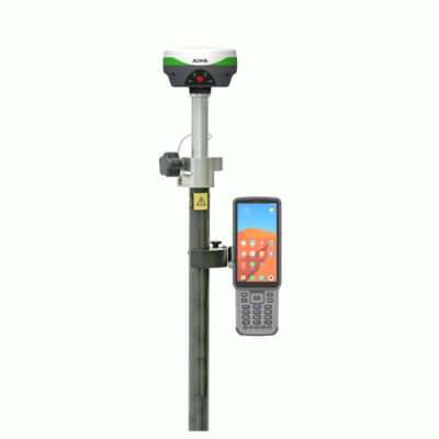
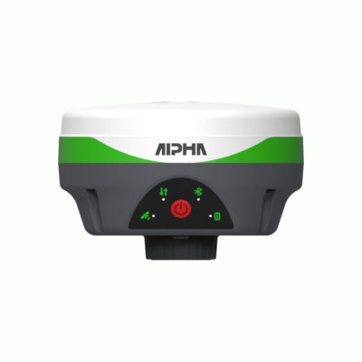
The Alpha 4i RTK GNSS Rover Base Set is a complete two-receiver positioning system for surveyors, construction teams, engineers, GIS professionals and drone-mapping crews. It includes Alpha 4i receivers for rover and base operation, an Alpha B55 data collector, DiMap Pro surveying software, a survey pole, controller bracket, tripod, tribrach and adapter.
Because the set includes its own base receiver, it can generate local RTK corrections on sites where an NTRIP correction network is unavailable or unsuitable. The internal UHF radios transmit corrections between the base and rover, while IMU tilt compensation helps users measure difficult points without keeping the pole perfectly vertical.
Alpha 4i Rover Base Set Highlights
| System configuration | Two Alpha 4i receivers for RTK rover and base operation |
|---|---|
| GNSS channels | 1,408 channels per receiver |
| Satellite constellations | GPS, GLONASS, Galileo, BeiDou, QZSS, SBAS and NavIC |
| RTK accuracy | Horizontal ±(8 + 1 ppm) mm and vertical ±(15 + 1 ppm) mm |
| IMU tilt compensation | 2 cm stated accuracy at 60° tilt with operation up to 120° |
| Internal UHF radio | 1 W transceiver operating from 410–470 MHz |
| Local radio range | Up to approximately 3 km in suitable conditions |
| Receiver protection | IP67 with stated 1.5 m drop resistance |
| Receiver weight | 380 g per receiver |
Valued customers:










Find RTK Networks
Search NTRIP providers and connect to reliable RTK correction services.
Description
Independent RTK Rover and Base System
The Alpha 4i Rover Base Set gives field teams the equipment needed to create their own local centimetre-level RTK correction system. One Alpha 4i receiver is installed as the base station over a known or established position, while the second receiver is used as the rover. Corrections are transmitted from the base to the rover through the receivers’ internal UHF radios.
This setup is useful on construction sites, rural projects and temporary survey areas where mobile coverage or an NTRIP correction service cannot be relied upon. It also gives users greater control over the position of the base, the working area and the correction link used for the project.
Complete Equipment for Field Deployment
The set combines two Alpha 4i GNSS receivers with an Alpha B55 data collector, DiMap Pro surveying software, a telescopic survey pole and controller bracket. A tripod, tribrach and adapter are included for stable base-station installation.
Bringing these components together in one package makes the system suitable for teams that need a complete RTK setup rather than a rover that depends entirely on an external correction network. The controller and software are used to configure the receivers, establish the base, monitor the RTK solution, collect measurements and set out design points.
1,408-Channel Multi-Constellation GNSS
Each Alpha 4i receiver uses 1,408 channels to track GPS, GLONASS, Galileo, BeiDou, QZSS, SBAS and NavIC signals across multiple frequencies. Access to a broad range of signals gives the system more satellites to work with throughout the day.
For the operator, this can support more dependable positioning when the view of the sky is partly restricted by buildings, trees, machinery or nearby terrain. Satellite availability, multipath and radio conditions still affect performance, so important measurements should always be checked against site control and the reported RTK solution quality.
Centimetre-Level RTK Surveying
The Alpha 4i is specified for RTK accuracy of ±(8 + 1 ppm) mm horizontally and ±(15 + 1 ppm) mm vertically under suitable operating conditions. This makes the rover and base set suitable for common professional tasks including topographic surveys, construction layout, infrastructure measurement, utility mapping, earthwork checks and ground control point collection.
The ppm component means that a small distance-dependent allowance is added as the separation between the rover and base increases. Keeping the base reasonably close to the working area and installing it in a clear, stable position helps achieve the best practical results.
IMU Tilt Compensation for Restricted Points
The rover receiver includes an IMU that compensates for pole tilt. Instead of carefully levelling the pole for every measurement, the operator can reach points beside walls, fences, kerbs, excavations, vegetation and other obstructions while the software calculates the position at the pole tip.
The manufacturer states approximately 2 cm tilt-measurement accuracy at a 60° pole angle and an operating range extending to 120°. In normal fieldwork, the main benefit is a faster and more comfortable workflow when measuring locations that are difficult to occupy with a vertical pole.
Integrated UHF Base to Rover Communication
Both receivers contain a 1 W UHF transceiver operating across the 410–470 MHz band. The radios support commonly used protocols including TrimTalk, TrimMark, SOUTH and SATEL formats, helping the system work with a range of compatible RTK equipment.
The stated internal radio working range is up to approximately 3 km under suitable conditions. Actual range depends on terrain, buildings, vegetation, antenna height, interference and permitted radio settings. For larger areas, the receiver can also be used with a compatible external radio where local regulations allow.
DiMap Pro Field Surveying Software
DiMap Pro is an Android surveying application for configuring the GNSS equipment and completing measurement work in the field. It includes separate rover, base and static operating modes, allowing the same software to manage the complete two-receiver system.
Survey functions include point collection, detail surveying, control-point work, point and line stakeout, road stakeout, CAD mapping, CAD stakeout, DSM stakeout and utility-related workflows. Project tools are available for coordinate systems, localization, point calibration, code libraries, grid-to-ground settings and data import or export.
This range of functions allows construction workers to set out coordinates and lines, surveyors to collect coded detail, GIS teams to record assets and drone operators to measure ground control points. CAD and survey data can be moved between field and office workflows using commonly used formats such as CSV, DXF and KML.
Alpha B55 Data Collector
The included Alpha B55 controller provides a dedicated field interface for DiMap Pro and the connected GNSS receivers. Its physical keyboard can be useful when working with gloves or entering point names and codes repeatedly. Mobile connectivity also allows the controller to access internet-based correction services when the system is used as a network rover instead of a local base and rover pair.
The controller therefore gives the set two practical correction workflows. Crews can use the included base where no network is available, or connect the rover to an NTRIP service when that is more convenient for the project.
Compact and Durable Receiver Design
Each Alpha 4i receiver measures approximately 98 mm by 53 mm and weighs 380 g. The low weight reduces the load at the top of the rover pole and makes both receivers easier to transport between projects.
The housing uses a reinforced aluminium-alloy structure with a signal-transparent top section. It is rated IP67 against dust and temporary water exposure and is specified to resist a 1.5 m drop under stated test conditions. The operating-temperature range is listed as −30°C to +70°C, supporting use across a wide range of outdoor working environments.
Battery Performance for Rover and Base Work
Receiver operating time varies according to the selected communication mode. The stated figures are up to 18 hours in network mode, 15 hours while receiving UHF corrections and 8 hours while transmitting as a radio base. Temperature, radio power, battery age and receiver settings can reduce practical working time.
USB Type-C charging and support for external power make it possible to extend operation during longer projects. For full-day base use, an external power source can be especially useful because transmitting corrections requires more energy than rover reception.
Typical Applications
- Topographic and detail surveying
- Construction positioning and stakeout
- Road, utility and infrastructure projects
- Earthwork, grade and elevation checks
- GIS asset and feature collection
- Ground control points for drone surveys
- Remote projects without dependable NTRIP coverage
When to Choose a Rover Base Set
A rover and base set is the practical choice when the working area does not have a suitable correction network, when mobile data coverage is unreliable or when the user wants direct control over the project base station. It is also suitable for contractors who move between different countries or regions where correction-service availability varies.
Projects that are always completed within a dependable RTK network may only require a rover set. A two-receiver package offers greater independence, but it also requires the base to be installed securely, configured correctly and assigned reliable coordinates before work begins.
Configuration and Support from Global GPS Systems
Global GPS Systems can help configure the Alpha 4i Rover Base Set for the required radio frequencies, correction protocol, coordinate system and field workflow. The included controller, software and mounting accessories can also be adjusted where a different pole, tablet or data-collection arrangement is preferred.
This support helps surveying companies, construction teams, GIS users and drone operators start with a setup suited to their actual projects while retaining the flexibility to work with either a local base station or an available RTK correction network.
Specifications
Alpha 4i Rover Base Set Specifications
System Overview
| Product Type | Complete RTK GNSS rover and base surveying system |
|---|---|
| System Configuration | Two Alpha 4i multi-constellation GNSS receivers configured as one rover and one base station |
| Field Controller | Alpha B55 rugged Android data collector |
| Field Software | Alpha DiMap Pro surveying software |
| Primary Applications | Land surveying, construction layout, cadastral surveying, topographic surveying, control-point measurement, detail surveying, mapping and stakeout |
| Correction Link | Integrated UHF radio link between the base and rover |
| Network RTK Support | Supported through the connected field controller using a compatible internet connection and NTRIP correction service |
| Receiver Cellular Modem | No integrated cellular modem |
| Tilt Surveying | IMU-compensated rover measurements without precisely levelling the survey pole |
Base and Rover Operation
| Component | Primary Function | Correction Communication |
|---|---|---|
| Alpha 4i Base Receiver | Installed over a known or measured reference point and transmits GNSS correction data | Integrated 410–470 MHz UHF radio or compatible external radio |
| Alpha 4i Rover Receiver | Receives correction data and calculates centimetre-level field positions | Integrated UHF radio or network corrections through the controller |
| Alpha B55 Controller | Receiver configuration, data collection, mapping, coordinate management and stakeout | Bluetooth connection to the receiver; 4G or Wi-Fi for compatible NTRIP services |
GNSS Receiver Technology
| GNSS Channels | 1408 |
|---|---|
| Positioning Engine | NebulasIV radio-frequency baseband and high-precision positioning system-on-chip |
| Operating System | Embedded real-time operating system |
| Supported Constellations | GPS, BeiDou, GLONASS, Galileo, QZSS, SBAS and NavIC |
| Supported Satellite Systems | Seven satellite systems with multi-frequency signal tracking |
| GNSS Antenna | Integrated 8 cm all-constellation, full-frequency positioning antenna |
| Antenna Design | Four-feed-point phase-centre design with high-frequency microwave radiation carrier, electromagnetic band-gap technology and high-gain wide-beam reception |
| Frequency Tracking | Independent frequency-point tracking |
| Anti-Interference | 60 dB narrow-band interference suppression |
| Position Update Rate | Up to 100 Hz |
| Internal Data Format | DAT |
Satellite Signal Tracking
| Satellite System | Supported Signals |
|---|---|
| GPS | L1C/A, L1C, L2C, L2P, L5 |
| BeiDou | B1I, B2I, B3I, B1C, B2a, B2b |
| GLONASS | G1, G2, G3 |
| Galileo | E1, E5a, E5b, E6 |
| QZSS | L1C/A, L1C, L2C, L5 |
| SBAS | L1 |
| NavIC | L5 |
Positioning Accuracy
| Positioning Mode | Horizontal Accuracy | Vertical Accuracy |
|---|---|---|
| High-Precision Static | ±(2.5 + 0.5 × 10⁻⁶D) mm | ±(5 + 0.5 × 10⁻⁶D) mm |
| RTK | ±(8 + 1 × 10⁻⁶D) mm | ±(15 + 1 × 10⁻⁶D) mm |
| Distance Variable | D represents the measured baseline distance |
|---|---|
| PPP Capability | Satellite differential PPP service listed as an upgrade-supported function |
| PPP Convergence | Approximately 15 minutes to 10 cm accuracy under suitable conditions |
IMU Tilt Compensation
| Tilt Sensor | Integrated inertial measurement unit |
|---|---|
| Tilt Compensation Accuracy | ±(8 + 0.3 × tilt angle) mm |
| Specified Tilt Performance | Approximately 2 cm accuracy at a pole tilt of up to 60° under suitable conditions |
| IMU Operating Angle | 0° to 120° |
| Initialization | Fast IMU initialization |
| Pole Levelling | Precise pole levelling is not required while valid IMU tilt compensation is active |
Integrated UHF Radio
| Radio Type | Integrated UHF transceiver |
|---|---|
| Frequency Range | 410–470 MHz |
| Operating Modes | Transmit and receive |
| Internal Radio Power | 1 W |
| Typical Base-to-Rover Range | Up to 3 km under suitable terrain, radio and environmental conditions |
| External Radio Compatibility | Compatible with external radios rated up to 35 W |
| Radio Antenna Connector | SMA |
| Supported Protocols | TRIMTALK 450S, TRIMMARK III, SOUTH9600, SOUTH19200, SATEL9600, SATEL19200 and Transparent |
Receiver Communications and Interfaces
| Bluetooth | Bluetooth 5.0 with backward compatibility |
|---|---|
| Controller Connection | Wireless Bluetooth connection to the Alpha B55 or another compatible Android device |
| Network Corrections | Supported through the controller using mobile data or Wi-Fi and a compatible NTRIP service |
| USB Interface | USB Type-C |
| USB Functions | Charging and data connection |
| Status Indicators | Satellite, data-link, Bluetooth and battery indicator lights |
| Radio Port | SMA antenna connection |
Receiver Power and Operating Time
| Operating Mode | Typical Operating Time |
|---|---|
| Network / CORS Mode | Up to 18 hours |
| UHF Receive Mode | Up to 15 hours |
| UHF Transmit Mode | Up to 8 hours |
| Input Voltage | 5–12 V Power Delivery |
|---|---|
| Charging Interface | USB Type-C fast charging |
| External Power | Supports operation from a compatible external power bank |
Receiver Physical Specifications
| Dimensions | 98 × 53 mm, excluding the 5/8-inch mounting interface |
|---|---|
| Weight | 380 g per receiver |
| Top Cover Material | Nano-material, radio-transparent construction |
| Housing Material | Reinforced aluminium alloy |
| Threaded Connector Material | 316 molybdenum stainless steel |
| Mounting Interface | Standard 5/8-inch survey pole or tribrach-adapter interface |
| Form Factor | Ultra-compact integrated receiver and antenna design |
Receiver Environmental Specifications
| Ingress Protection | IP67 dustproof and waterproof |
|---|---|
| Operating Temperature | -30°C to +70°C |
| Storage Temperature | -40°C to +80°C |
| Drop Resistance | Designed to withstand a 1.5 m drop onto hard ground at normal temperature |
| Humidity Resistance | Up to 100% |
| Additional Protection | Integrated protective rubber gasket |
Alpha B55 Field Controller
| Controller Type | Rugged Android GNSS data collector |
|---|---|
| Operating System | Android 11 |
| Processor | Octa-core 2.0 GHz processor |
| Memory | 4 GB RAM |
| Internal Storage | 64 GB |
| Display Size | 5.5 inches |
| Display Resolution | 720 × 1440 pixels |
| Cellular Connectivity | Integrated 4G modem for compatible mobile-data and NTRIP workflows |
| Receiver Connection | Bluetooth |
| Ingress Protection | IP67 |
| CAD Processing | Supports CAD files larger than 100 MB, multiple layers, multiple text encodings and integrated drawing functions |
DiMap Pro Surveying Software
| Software Platform | Android |
|---|---|
| Project Management | Project creation, opening, removal, sharing and project-based data storage |
| Coordinate Functions | Coordinate-system configuration, localization, control-point calibration, grid-to-ground conversion and coordinate transformation |
| Receiver Configuration | Bluetooth communication, rover setup, base setup, static configuration, device information and positioning restart |
| Point Surveying | Point survey, detail survey and control-point survey |
| Stakeout Functions | Point, line, road, CAD, DSM, spiral, electric-tower, electric-line and photovoltaic stakeout |
| Mapping Functions | CAD mapping, polyline surveying and polygon surveying |
| Data Management | Point database, code-library management, layer management, data import and data export |
| Field Calculations | Area, perimeter, volume, coordinate, line, circle, offset, intersection, resection and average calculations |
| Interface Customization | Customizable function menus and survey workflow layout |
| Typical Export Formats | CSV, DXF, KML and other supported surveying formats |
Survey Pole and Base Setup Equipment
| Rover Pole Type | Portable telescopic or collapsible centring pole |
|---|---|
| Extended Rover Pole Length | Approximately 1.5 m |
| Collapsed Rover Pole Length | Approximately 50 cm |
| Controller Bracket | Pole-mounted holder for the Alpha B55 field controller |
| Base Tripod | Survey tripod for stable base-station installation |
| Tribrach | Levelling tribrach for centring and levelling the base receiver |
| Tribrach Adapter | Adapter connecting the Alpha 4i receiver to the tribrach assembly |
| Receiver Mount | Standard 5/8-inch threaded interface |
| Receiver Carrying Case | Industrial-grade compact hard case |
| Compact Case Dimensions | Approximately 27 × 23 × 11 cm |
Rover Base Set Package Contents
| Item | Quantity | Notes |
|---|---|---|
| Alpha 4i GNSS Receiver | 2 | One receiver for rover operation and one receiver for base-station operation |
| Alpha B55 Field Controller | 1 | Rugged Android controller with 4G connectivity |
| DiMap Pro Surveying Software | 1 license | Receiver configuration, data collection, mapping and stakeout software |
| UHF Radio Antenna | 2 | For the integrated 410–470 MHz radios |
| Receiver Power Adapter | 2 | Receiver charging accessories |
| Receiver USB Data Cable | 2 | For charging and data connection |
| Controller Charger and Cable | 1 set | For charging and data connection |
| Controller Bracket | 1 | Mounts the field controller to the rover pole |
| Rover Survey Pole | 1 | Portable pole extending to approximately 1.5 m |
| Survey Tripod | 1 | For base-station installation |
| Tribrach | 1 | For centring and levelling the base receiver |
| Tribrach Adapter | 1 | Connects the base receiver to the tribrach |
| Instructions | 1 set | Receiver and software documentation |
| Protective Carrying Case | As configured | For receiver, controller and accessory transport |
Specifications and package contents may vary by configuration, region or manufacturer update. Always check the current configuration before ordering.
Reviews (0)
Only logged in customers who have purchased this product may leave a review.
FAQ
Alpha 4i Rover Base Set FAQ
System Overview and Applications
What is the Alpha 4i Rover Base Set?
The Alpha 4i Rover Base Set is a complete professional RTK GNSS surveying system with an Alpha 4i receiver for the base station and another Alpha 4i receiver for the rover. The base sends correction data to the rover, enabling centimetre-level positioning without relying entirely on a third-party RTK network.
Who is the Alpha 4i Rover Base Set designed for?
The system is designed for land surveyors, construction teams, civil engineers, utility contractors, GIS professionals, infrastructure companies and other field users who need accurate positioning from an independent base-and-rover setup.
What can the Alpha 4i Rover Base Set be used for?
Typical applications include topographic surveying, construction layout, cadastral measurements, point and line stakeout, road surveys, utility mapping, earthworks, site control, CAD-based fieldwork and the measurement of ground control points.
Why choose a rover and base set instead of a rover-only set?
A rover and base set allows you to generate and transmit your own RTK corrections. This is useful in remote areas, on temporary construction sites or wherever a suitable NTRIP or CORS correction network is unavailable, unreliable or not preferred.
Can the Alpha 4i receivers switch between base and rover operation?
Yes. Each Alpha 4i receiver can be configured for base or rover use. This gives teams flexibility when organizing equipment, replacing a receiver or adapting the system to different projects.
Is the Alpha 4i Rover Base Set suitable for construction stakeout?
Yes. The set can be used to set out points, lines, elevations and construction designs. IMU tilt compensation helps users measure and stake points near walls, excavations, structures and other locations where keeping the pole vertical is difficult.
Accuracy, GNSS and Tilt Compensation
What RTK accuracy can the Alpha 4i achieve?
Under suitable RTK conditions, the specified horizontal accuracy is approximately 8 mm plus 1 ppm and the vertical accuracy is approximately 15 mm plus 1 ppm. Actual results depend on satellite visibility, base-to-rover distance, radio quality, multipath, atmospheric conditions and surveying procedures.
How many GNSS channels does each Alpha 4i receiver have?
Each Alpha 4i receiver has 1,408 channels for tracking multiple satellite constellations and frequencies simultaneously.
Which satellite constellations does the Alpha 4i support?
The Alpha 4i supports GPS, GLONASS, Galileo, BeiDou, QZSS, SBAS and NavIC signals. Tracking several constellations helps improve satellite availability and positioning reliability in demanding environments.
Which GNSS frequencies are supported?
The receiver supports multiple frequencies, including GPS L1, L2 and L5, GLONASS G1, G2 and G3, Galileo E1, E5 and E6, and multiple BeiDou B1, B2 and B3 signals.
What is IMU tilt compensation?
IMU tilt compensation calculates the position of the survey-pole tip while the rover pole is tilted. This allows users to collect accurate measurements without carefully levelling the pole for every point.
How far can the Alpha 4i rover be tilted?
The Alpha 4i supports tilt-compensated measurements at angles up to 60 degrees. The specified tilt accuracy is approximately 2 cm at a 60-degree angle under suitable operating conditions.
Base Station, Radio and Corrections
How does the base station send corrections to the rover?
The base receiver calculates correction data from its known or configured position and transmits that data to the rover through the integrated UHF radio. The rover applies the corrections in real time to produce an RTK fixed position.
What UHF frequency range does the Alpha 4i use?
The integrated UHF transceiver operates within the 410–470 MHz frequency range. Radio frequencies, channels and transmission power must be configured in accordance with local regulations.
What is the expected UHF radio range?
The Alpha 4i is specified to support a base-station working area of up to approximately 3 km under suitable conditions. Actual range depends on terrain, antenna height, buildings, vegetation, interference, radio settings and local transmission restrictions.
Which radio protocols are supported?
The Alpha 4i supports commonly used protocols including TrimTalk 450S, TrimMark III, SOUTH9600, SOUTH19200, SATEL9600, SATEL19200 and transparent transmission.
Can the Alpha 4i Rover Base Set work with an external radio?
Yes. The system can be used with a compatible external radio when a different transmission setup or a longer working range is required. Frequency, protocol, cable and legal compatibility must be confirmed before use.
Can the rover also receive NTRIP corrections?
Yes. The rover can receive corrections from an NTRIP or CORS service through an internet-connected controller and compatible field software. This allows users to choose between their own UHF base station and a network RTK workflow.
Included Equipment, Software and Field Use
What is included in the Alpha 4i Rover Base Set?
The standard configuration includes Alpha 4i receivers for rover and base operation, an Alpha B55 data collector, DiMap Pro surveying software, a rover pole, data-collector bracket, tripod, tribrach and adapter. The exact package contents should be confirmed for the selected configuration.
What is the Alpha B55 data collector used for?
The Alpha B55 is a rugged Android field controller used to configure the base and rover, manage projects, connect to RTK correction services, collect points, perform stakeout and import or export survey data.
What functions are available in DiMap Pro?
DiMap Pro supports base and rover configuration, point and detail surveys, control-point measurement, point and line stakeout, CAD mapping, road stakeout, utility workflows, coordinate-system management and survey-data import and export.
Which survey data formats can be used?
Depending on the selected workflow, DiMap Pro supports commonly used formats such as CSV, DXF and KML. CAD drawings can also be used for field mapping and stakeout tasks.
How long do the Alpha 4i receiver batteries last?
The specified operating time is up to 18 hours in network mode, approximately 15 hours while receiving UHF corrections and approximately 8 hours while transmitting UHF corrections. Actual battery life varies with radio power, temperature, connectivity and battery condition.
Can the Alpha 4i receivers be powered by an external power bank?
Yes. The receivers support USB Type-C charging and compatible external power delivery. A suitable power bank can help extend operation during long surveys, particularly when the base receiver is continuously transmitting corrections.
Is the Alpha 4i suitable for harsh outdoor conditions?
Yes. Each receiver has an IP67 dustproof and waterproof rating and uses a reinforced nano-material and aluminium-alloy housing. It is also specified to withstand a drop of up to 1.5 metres under normal test conditions.


 GPS & GNSS
 Total Stations
 Data collectors
 Software
 Correction services
 Machine control
 External radio
 Marine
 Accessories
Reviews
There are no reviews yet