

 GPS & GNSS
 Lidar scanning
 Total Station
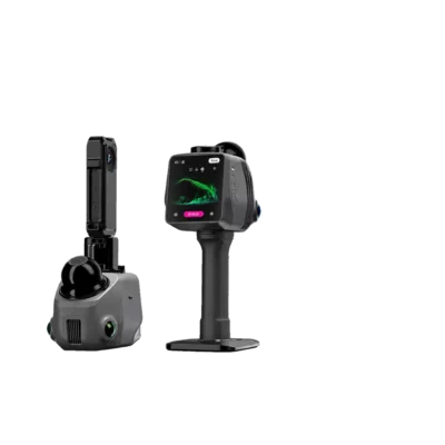
3DMakerpro Raven Max SLAM LiDAR 3D Scanner with Dual Cameras
Get the best price for your setup
Contact our experts for the best possible price and configuration.
- Fast response
- Expert configuration advice
- No overpaying for features you do not need
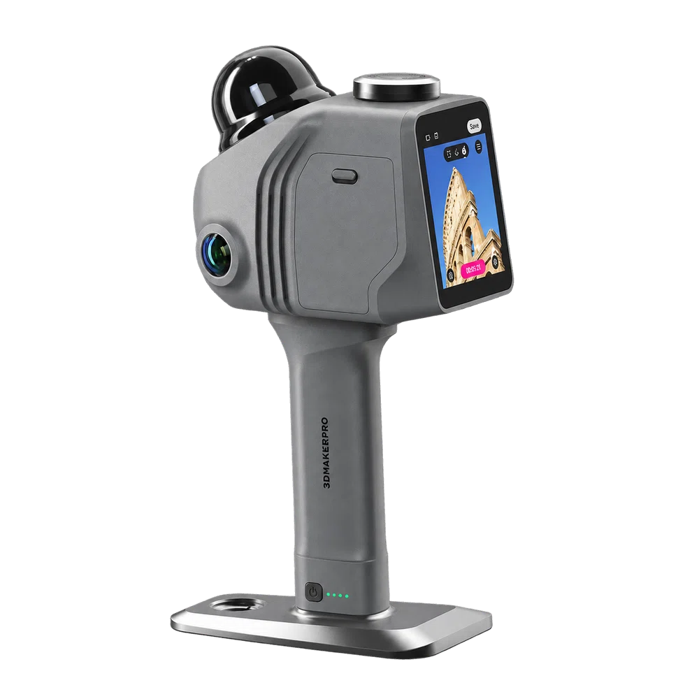
The 3DMakerpro Raven Max is a portable handheld SLAM LiDAR 3D scanner designed for capturing buildings, construction sites, industrial facilities and outdoor environments. Equipped with dual 12 MP colour cameras, it combines detailed laser measurements with visual information to create colourised point clouds and realistic 3D representations of existing spaces.
With a scanning range of up to 100 metres, a specified accuracy of 2 cm at 10 metres and a capture rate of 150,000 points per second, the Raven Max helps surveyors, engineers and construction professionals document complex environments efficiently. Its lightweight 1.1 kg design, integrated AMOLED display and removable battery grip with up to two hours of operation make it practical for everyday fieldwork. RayStudio software supports point cloud processing, 3D modelling workflows and Gaussian Splatting visualisation.
3DMakerpro Raven Max Highlights
| Scanning technology | Handheld SLAM LiDAR 3D scanning |
|---|---|
| Colour cameras | Dual 12 MP cameras with 1/2-inch sensors |
| Scanning accuracy | 2 cm at 10 m; 3 cm at 20 m; 5 cm at 40 m |
| Scanning range | Up to 100 m; effective scan radius 40–50 m depending on reflectivity |
| Point cloud capture | 150,000 points per second |
| Field of view | 360° horizontal and 40° vertical |
| Display | 3.9-inch AMOLED |
| Battery | 12,000 mAh removable battery grip; up to 2 hours operation |
| Weight | 1.1 kg |
| Data formats | LAS, PCD, PLY, OBJ, E57 and XYZ |
| Positioning | SLAM mapping; RTK kit not included in Raven Max configuration |
You may also like…
Lidar & 3D scanning
3DMakerpro Raven Handheld SLAM LiDAR 3D Scanner with 100m Range
Valued customers:


Find RTK Networks
Search NTRIP providers and connect to reliable RTK correction services.
Description
3DMakerpro Raven Max Handheld SLAM LiDAR 3D Scanner
The 3DMakerpro Raven Max is a professional handheld SLAM LiDAR scanner designed for capturing detailed 3D measurements and colour information from real-world environments. Combining high-speed laser scanning with two 12 MP cameras, it allows surveyors, engineers, construction professionals and 3D mapping specialists to document buildings, construction sites, industrial facilities and outdoor spaces while moving through the area being scanned.
With a maximum specified scanning range of 100 metres, an accuracy of 2 cm at 10 metres and a capture speed of up to 150,000 points per second, the Raven Max provides a practical way to record complex environments without measuring every object individually. Its compact 1.1 kg design, integrated screen and removable battery grip make it suitable for both indoor and outdoor scanning projects.
Dual 12 MP Cameras for Detailed Colour 3D Capture
One of the main advantages of the 3DMakerpro Raven Max is its dual-camera imaging system. Unlike the standard Raven, which uses a single 12 MP camera, the Raven Max features two 12 MP cameras with 1/2-inch sensors to capture visual information alongside the LiDAR measurements.
This additional imaging capability is particularly useful when creating colourised point clouds and realistic 3D models. Instead of working only with the shape and position of scanned objects, users can also see surface colours and visual details that make a digital environment easier to recognise and interpret.
For architects and building surveyors, colour information can help identify walls, floors, doors, windows and different materials during existing-condition documentation. Construction teams can use it to review visible installations and site conditions, while industrial inspection teams can document machinery, equipment and surrounding structures in a more recognisable 3D environment.
The camera system also supports high-resolution visual capture for Gaussian Splatting workflows, making the Raven Max suitable for projects where both geometric information and realistic visual presentation are important.
SLAM LiDAR Technology for Mobile 3D Mapping
The Raven Max uses Simultaneous Localisation and Mapping (SLAM) technology to create a three-dimensional representation of an environment while the operator moves. By processing LiDAR measurements together with supporting tracking information, the scanner estimates its movement and connects the collected data into a continuous point cloud.
This approach reduces the need to reposition a stationary scanner repeatedly when documenting rooms, corridors, warehouses or other connected spaces. Users can walk through an environment while the scanner records surrounding surfaces, making it practical for projects where mobility and efficient data collection are important.
SLAM scanning is particularly useful for documenting existing buildings, industrial installations and renovation projects. A single scanning session can capture the relationships between many different structural and architectural features, providing a digital reference for subsequent measurements and modelling.
Scan quality depends on environmental conditions and the route followed during data collection. Maintaining appropriate scanning speed, capturing overlapping geometry and closing scanning loops where possible can help reduce accumulated mapping errors.
Centimetre-Level LiDAR Accuracy
The Raven Max provides specified LiDAR measurement accuracy of 2 cm at 10 metres, 3 cm at 20 metres and 5 cm at 40 metres. This level of performance makes it useful for spatial documentation, building measurement, engineering reference models and inspections where the overall geometry of an environment needs to be recorded.
For construction teams, the scanner can help capture existing walls, columns, structural elements and visible installations before renovation or further work begins. Engineers can use the resulting point cloud to inspect spatial relationships, identify features and prepare reference data for design or maintenance planning.
The stated accuracy relates to the LiDAR measurement performance at specified distances. The overall accuracy of a completed SLAM survey can also be influenced by scan alignment, accumulated drift, processing methods and environmental conditions. Projects requiring verified survey coordinates or strict engineering tolerances should incorporate appropriate control and quality checks.
Up to 100 Metres Scanning Range
With a maximum specified scanning range of 80 to 100 metres, the Raven Max can capture both indoor spaces and larger outdoor environments. The LiDAR detection radius is specified at approximately 40 metres for surfaces with 10% reflectivity and 50 metres for surfaces with 80% reflectivity.
In everyday fieldwork, this means the effective distance depends on the surfaces being scanned. Bright, reflective objects can generally be detected from greater distances than dark or low-reflectivity materials. Site conditions, atmospheric visibility and the angle of the scanned surfaces can also influence the results.
The extended range is useful for documenting building exteriors, large industrial halls, infrastructure features and open construction environments. It allows professionals to collect spatial information from surfaces that may be difficult or inconvenient to approach directly.
360-Degree Scanning and High-Density Point Clouds
The Raven Max combines a 360° horizontal field of view with a 40° vertical field of view. This enables the scanner to record its surroundings across all horizontal directions as the operator moves through a project area.
At a capture rate of up to 150,000 points per second, it generates detailed point clouds that represent visible surfaces such as floors, walls, structural elements, machinery and external site features. The resulting data provides a spatial record that can be inspected and processed after the survey.
For building documentation, a point cloud offers a more complete view of existing geometry than a series of individual measurements. For industrial applications, it helps capture complex arrangements of equipment and installations that may be difficult to describe using conventional drawings alone.
Because the vertical field of view is limited to 40°, additional passes or adjustments to the scanner orientation may be needed to capture high ceilings, elevated details or surfaces that are otherwise outside the scanner’s direct line of sight.
Lightweight Handheld Design for Construction and Surveying
Weighing approximately 1.1 kg, the Raven Max is designed for portable field operation. Its compact dimensions of 148 × 288 × 98 mm make it manageable when moving through buildings, construction sites, tunnels and industrial environments.
The scanner features an integrated 3.9-inch AMOLED display that allows operators to control scanning functions and monitor data collection directly on the device. This reduces the need to use a separate laptop during routine scanning activities.
An onboard eight-core processor, internal memory and expandable TF card storage support standalone data acquisition. The 905 nm laser is classified as Class 1 under IEC 60825-1:2014.
Removable Battery Grip with Up to Two Hours of Operation
The Raven Max uses a removable 12,000 mAh battery grip that provides up to two hours of operation under specified conditions. This gives field teams time to document multiple rooms, sections of a building or a substantial scanning route before changing or recharging the battery.
For longer scanning sessions, additional battery grips or a suitable external power supply can help maintain operation. The scanner supports USB Type-C connectivity, 65 W USB-C power delivery and Wi-Fi 5 for communication and data transfer.
These features make the Raven Max practical for mobile teams working across different project locations without permanent access to an office workstation.
RayStudio Software for Point Cloud Processing
After collecting scan data, the 3DMakerpro Raven Max works with RayStudio software to process and prepare the captured information. RayStudio supports point cloud inspection, optimisation, noise reduction, colour processing and 3D visualisation.
Users can review scanned environments, remove unwanted points and prepare datasets for further work. The software also supports Gaussian Splatting, a visualisation technique that uses captured image information to create realistic digital representations of physical spaces.
This is useful for architectural presentations, facility documentation, property visualisation and digital twin applications. The geometric point cloud remains particularly valuable for measurement and technical analysis, while colour models and Gaussian Splatting provide additional visual context.
Supported export formats include LAS, PCD, PLY, OBJ, E57 and XYZ. These provide options for transferring data into compatible point cloud, CAD, GIS and 3D modelling software. Creating finished technical drawings or BIM models may require additional processing in specialist applications.
RayStudio desktop processing requires a compatible Windows computer. Gaussian Splatting processing is supported on NVIDIA graphics cards, and larger datasets benefit from sufficient RAM and GPU performance.
Applications for Surveyors, Engineers and Construction Professionals
The Raven Max is particularly useful for professionals who need to record the geometry and appearance of complex environments as part of their everyday work.
- Construction and renovation: Capture existing site conditions, structural geometry, building interiors and construction progress for documentation and planning.
- Architecture and building surveying: Create detailed point cloud references for floor plans, building models, renovation designs and as-built documentation.
- Industrial facilities: Record machinery, production areas, technical installations and equipment layouts for inspection, maintenance and redevelopment.
- Civil engineering and infrastructure: Document visible structural features, tunnels, bridges and surrounding spaces for spatial analysis and project records.
- GIS and asset mapping: Capture local 3D geometry that can be registered to suitable control points and integrated into compatible spatial data workflows.
- Digital twins and property visualisation: Generate colourised 3D environments and realistic visual representations of buildings and facilities.
Flexible Mounting Options for Different Scanning Projects
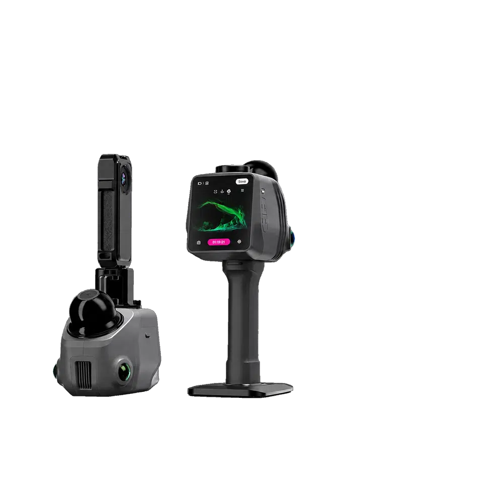
Although designed for handheld use, the Raven Max supports additional mounting accessories for more specialised applications. Compatible configurations include bicycle mounts, vehicle mounts, backpack scanning systems and suitable drone mounting arrangements.
These accessories can be useful for documenting larger outdoor areas, scanning along routes or collecting data where handheld operation is impractical. Vehicle and drone installations require suitable mounting, power arrangements and consideration of operating conditions.
Optional camera accessories also support selected Insta360 X4 and X5 panoramic cameras, providing additional possibilities for visual capture and 3D presentation.
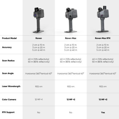
Raven Max Compared with Raven and Raven Max RTK
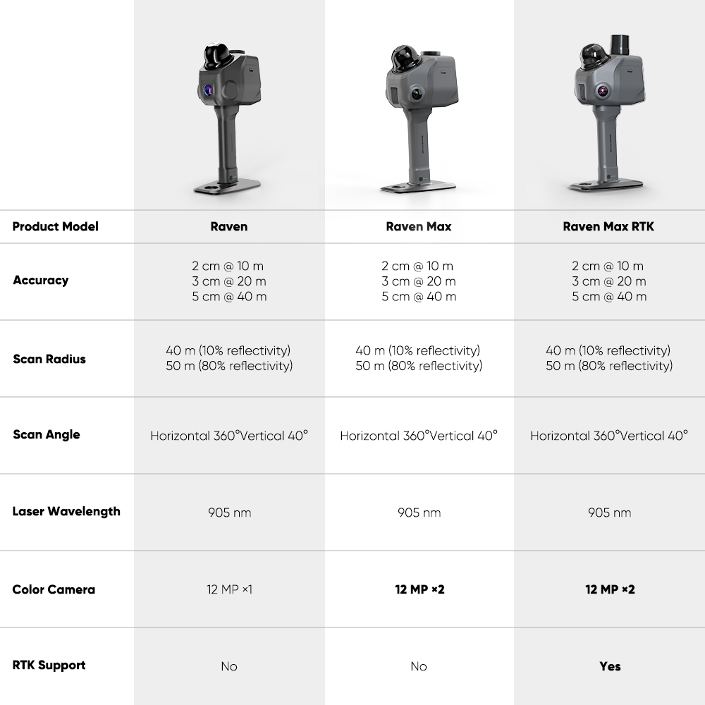
The Raven Max sits between the standard Raven and the Raven Max RTK in the 3DMakerpro Raven series. All three configurations use the same stated core LiDAR scanning performance, including a maximum scanning range of 100 metres and 150,000 points per second.
The standard Raven features one 12 MP camera, while the Raven Max has two 12 MP cameras for expanded colour image capture. This makes the Max particularly relevant for projects that require detailed spatial information together with realistic visual documentation.
The Raven Max RTK configuration adds dedicated RTK positioning equipment for workflows involving geographical coordinates. The regular Raven Max does not include this RTK kit and should not be described as providing RTK survey positioning out of the box.
For projects requiring alignment with established survey control or a national coordinate reference system, suitable positioning, registration and verification procedures remain necessary.
3DMakerpro Raven Max at Global GPS Systems
At Global GPS Systems, we help surveying, engineering and construction professionals choose suitable equipment for their measurement and mapping requirements. The 3DMakerpro Raven Max is a useful solution for teams that need portable LiDAR scanning combined with detailed colour 3D capture.
Whether you are documenting an existing building, preparing data for a renovation project or creating a digital representation of an industrial facility, our team can help you understand the Raven Max’s scanning capabilities, software requirements and available accessories. We can also advise on GNSS and RTK equipment when your project requires reliable geographical positioning alongside 3D scanning.
Datasheets & Manuals
Specifications
3DMakerpro Raven Max LiDAR 3D Scanner Specifications
General Specifications
| Manufacturer | 3DMakerpro |
|---|---|
| Model | Raven Max |
| Product Series | Raven |
| Product Type | Portable handheld LiDAR 3D spatial scanner |
| Scanning Technology | LiDAR with enhanced SLAM (Simultaneous Localization and Mapping) |
| Color Camera Configuration | Dual integrated 12 MP color cameras |
| Camera Resolution | 2 × 12 megapixels |
| Maximum Scanning Range | 100 m |
| Maximum Scanning Radius | 50 m at 80% target reflectivity |
| Point Cloud Acquisition Rate | 150,000 points/second |
| Field of View | 360° horizontal × 40° vertical |
| Positioning Technology | Enhanced SLAM using point cloud, image and inertial measurement data |
| Integrated RTK GNSS | Not included; RTK georeferencing is available with the separate Raven Max RTK edition |
| Color 3D Reconstruction | RGB point clouds, polygonal 3D models and 3D Gaussian Splatting |
| Integrated Display | 3.9-inch AMOLED touchscreen |
| Operating Method | Standalone handheld scanning and compatible accessory-mounted scanning |
| Operating Environments | Indoor and outdoor environments |
| Primary Applications | 3D surveying, spatial mapping, architecture, construction, BIM, digital twins, real estate, infrastructure documentation, facility management, geological mapping, cultural heritage and 3D visualization |
LiDAR Scanning Performance
| Scanning Principle | Laser-based 3D distance measurement with SLAM reconstruction |
|---|---|
| LiDAR Scanning Range | 80–100 m |
| Maximum Specified Range | 100 m |
| Scanning Radius at 10% Reflectivity | 40 m |
| Scanning Radius at 80% Reflectivity | 50 m |
| Minimum Scanning Distance | 0.5 m |
| Horizontal Field of View | 360° |
| Vertical Field of View | 40° |
| Combined Scanning Field of View | 360° × 40° |
| Point Cloud Acquisition Frequency | 150,000 points/second |
| Point Cloud Acquisition Rate | 150 kpts/s |
| Laser Wavelength | 905 nm |
| Laser Safety Class | Class 1 |
| Laser Safety Standard | IEC 60825-1:2014 |
| Real-Time 3D Scanning | Supported |
| Continuous Mobile Scanning | Supported |
| Colorized Point Cloud Acquisition | Supported through the integrated dual-camera system |
| Monochrome Point Cloud Acquisition | Supported |
| Indoor LiDAR Scanning | Supported |
| Outdoor LiDAR Scanning | Supported |
| Nighttime LiDAR Scanning | Supported; laser distance measurement does not depend on visible ambient light |
| Large-Scale Spatial Capture | Supported for buildings, infrastructure, streets, underground spaces and outdoor environments |
Measurement Accuracy
| Measurement Distance | Specified Accuracy | Equivalent in Millimeters |
|---|---|---|
| 0.5–10 m | Approximately 2 cm | 20 mm |
| 10 m | 2 cm | 20 mm |
| 20 m | 3 cm | 30 mm |
| 40 m | 5 cm | 50 mm |
Optical Camera and Imaging System
| Color Camera System | Integrated dual-camera RGB imaging system |
|---|---|
| Number of Color Cameras | 2 |
| Camera Resolution per Camera | 12 megapixels |
| Camera Configuration | 2 × 12 MP |
| Camera Sensor Size | 1/2 inch |
| Image Sensor Technology | Sony image sensor |
| Camera Lens Type | Fisheye camera system |
| Color Image Capture | 4K true-color imaging |
| Automatic Exposure Adjustment | Supported for indoor and outdoor lighting conditions |
| HDR Mode | Not supported |
| RGB Texture Capture | Supported |
| RGB Point Cloud Colorization | Supported |
| Image-Assisted SLAM | Supported |
| Camera-Assisted 3D Reconstruction | Supported |
| Gaussian Splatting Image Acquisition | Supported |
| External 360° Camera Support | Supported with compatible optional 360 Camera Kit |
| Compatible External Camera Models | Insta360 X4 and Insta360 X5 |
| Low-Light Color Capture | Dependent on available illumination; insufficient lighting may reduce RGB point cloud and Gaussian Splatting quality |
SLAM and Spatial Tracking
| SLAM Technology | Enhanced Simultaneous Localization and Mapping |
|---|---|
| SLAM Data Inputs | LiDAR point clouds, camera imagery and IMU data |
| Inertial Measurement Data | Integrated into the SLAM workflow |
| Image-Assisted Tracking | Supported |
| Continuous Scanner Trajectory Estimation | Supported |
| SLAM-Based Scan Alignment | Supported |
| Point Cloud Drift Reduction | Enhanced SLAM algorithms use multiple sensor inputs to reduce drift caused by movement |
| Real-Time Spatial Mapping | Supported |
| Mobile Mapping | Supported |
| Handheld Trajectory Tracking | Supported |
| GNSS Georeferencing | Not included in the Raven Max configuration |
| RTK Positioning | Not included; available with Raven Max RTK edition |
| Absolute Geographic Positioning | Requires a compatible georeferencing workflow or the Raven Max RTK edition |
| Standalone SLAM Operation | Supported without an external GNSS receiver |
| GNSS-Free Indoor Scanning | Supported |
Raven Max Model-Specific Features
| Model Configuration | Raven Max with dual 12 MP cameras |
|---|---|
| Camera Upgrade Compared With Standard Raven | Two integrated color cameras instead of one |
| Dual-Camera Color Capture | Supported |
| Enhanced RGB Reconstruction | Dual-camera image acquisition for colorized point cloud and visual reconstruction workflows |
| 4K Visual Capture | Supported |
| Gaussian Splatting | Supported |
| 3D Mesh Reconstruction | Supported through compatible processing software |
| Integrated GNSS Receiver | No integrated RTK GNSS georeferencing in this edition |
| RTK Upgrade Availability | RTK capability is offered with the separate Raven Max RTK edition; the manufacturer does not list the RTK module as an independently sold upgrade |
Integrated Processing and Storage
| Integrated Processor | 8-core processor |
|---|---|
| Processor Clock Speed | 2.4 GHz |
| Processor Configuration | 8 cores at 2.4 GHz |
| Onboard Storage | 32 GB |
| Expandable Storage | Supported |
| Storage Expansion Type | TF card (microSD) |
| Included Removable Storage | 128 GB TF card |
| Standalone Data Acquisition | Supported |
| Onboard SLAM Processing | Supported |
| Real-Time Scanner Processing | Supported |
| External Computer Required During Basic Scanning | No |
| Desktop Post-Processing | Available through 3DMakerpro RayStudio software |
Display and User Interface
| Display Size | 3.9 inches |
|---|---|
| Display Technology | AMOLED |
| Touchscreen | Supported |
| Integrated Display | Yes |
| On-Device Operation | Supported |
| Scanning Status Monitoring | Supported |
| Real-Time Scanning Feedback | Supported |
| Point Cloud Preview | Supported |
| Portable User Interface | Integrated touchscreen and on-device scanner controls |
Connectivity and Data Interfaces
| USB Data Interface | 1 × USB Type-C |
|---|---|
| Power Delivery Interface | 1 × USB Type-C, 65 W USB Power Delivery |
| Wireless Connectivity | Wi-Fi |
| Wi-Fi Standard | Wi-Fi 5 (IEEE 802.11ac) |
| Removable Storage Interface | TF card (microSD) |
| Computer Data Transfer | Supported using compatible USB and removable storage workflows |
| External Power Connection | Supported |
| External 360° Camera Expansion | Supported with compatible mounting kit |
| Accessory Mounting Support | Bicycle, motorcycle, automotive, backpack and compatible drone mounting solutions |
Battery and Power Supply
| Battery Type | Rechargeable removable battery grip |
|---|---|
| Battery Capacity | 12,000 mAh |
| Maximum Operating Time | Up to 2 hours |
| Maximum Operating Time in Minutes | 120 minutes |
| Quick-Release Battery Design | Yes |
| Swappable Battery Grip | Supported |
| External Power Supply | Supported |
| Operation While Charging | Supported |
| USB Power Delivery | 65 W PD |
| Power Connection Type | USB Type-C |
| Extended Field Operation | Supported through battery replacement or compatible external power supply |
| Additional Battery Compatibility | 3DMakerpro Raven series battery grip |
| Operating Time Conditions | Actual runtime depends on operating configuration, environmental conditions and connected accessories |
Physical Specifications
| Dimensions | 148 × 288 × 98 mm |
|---|---|
| Dimensions in Centimeters | 14.8 × 28.8 × 9.8 cm |
| Specified Weight | 1.1 kg |
| Weight in Grams | 1,100 g |
| Design | Portable handheld scanner with detachable battery grip |
| Display Integration | Integrated into the scanner body |
| Battery Handle | Removable and replaceable |
| Handheld Operation | Supported |
| Standalone Field Operation | Supported |
| Accessory-Mounted Operation | Supported with compatible mounting equipment |
| Protective Accessory | Protective cover included with standard package |
Operating Environment and Safety
| Recommended Operating Temperature | 0°C to +35°C |
|---|---|
| Recommended Operating Temperature (Fahrenheit) | 32°F to 95°F |
| Extreme Low-Temperature Tolerance | Manufacturer states tolerance down to approximately -10°C; sub-zero operation is not recommended |
| Indoor Operation | Supported |
| Outdoor Operation | Supported |
| Low-Light LiDAR Operation | Supported |
| Nighttime LiDAR Operation | Supported |
| Low-Light RGB Imaging | Limited by available illumination |
| Laser Wavelength | 905 nm |
| Laser Safety Classification | Class 1 |
| Laser Safety Standard | IEC 60825-1:2014 |
| Ingress Protection Rating | Not specified by manufacturer |
| Waterproof Rating | Not specified by manufacturer |
3D Reconstruction and Output Capabilities
| 3D Point Cloud Generation | Supported |
|---|---|
| Colorized 3D Point Clouds | Supported |
| Monochrome Point Clouds | Supported |
| Polygonal 3D Model Reconstruction | Supported through processing software |
| Color Mesh Export | Supported |
| 3D Gaussian Splatting | Supported |
| Gaussian Splatting Export | PLY |
| RGB Point Cloud Export | PLY and other supported point cloud formats |
| Polygonal Model Export | OBJ |
| 4K Image-Based Reconstruction | Supported |
| Color Texture Mapping | Supported |
| Large-Scale Scene Reconstruction | Supported |
| Building and Interior Reconstruction | Supported |
| Outdoor Environment Reconstruction | Supported |
| Digital Twin Data Creation | Supported |
| Gaussian Splatting GPU Requirement | NVIDIA GPU required for the manufacturer's processing workflow |
| Online 3D Scene Publishing | Supported through compatible JIMUMETA services |
Supported File Formats
| File Format | Data Type | Application |
|---|---|---|
| LAS | LiDAR point cloud | Surveying, GIS, spatial analysis and point cloud exchange |
| PCD | Point cloud data | 3D processing, point cloud analysis and compatible engineering workflows |
| PLY | Colorized point cloud and 3D data | 3D visualization, color point clouds and Gaussian Splatting |
| OBJ | Polygonal 3D model | 3D modeling, mesh visualization and compatible CAD workflows |
| E57 | Standardized 3D point cloud exchange | Surveying, laser scanning and point cloud interoperability |
| XYZ | 3D coordinate point data | Point cloud exchange and spatial coordinate analysis |
| LAZ | Compressed LiDAR point cloud | Listed in the manufacturer's software compatibility FAQ; availability may depend on RayStudio version |
Software and Data Processing
| Official Desktop Software | 3DMakerpro RayStudio |
|---|---|
| Software Purpose | Point cloud processing, visualization, optimization, reconstruction and export |
| Point Cloud Visualization | Supported |
| Color Point Cloud Processing | Supported |
| AI-Assisted Point Cloud Denoising | Supported |
| One-Click Denoising | Supported |
| Point Cloud Optimization | Algorithm-based refinement of point cloud density and surface data |
| Point Cloud Inspection | Supported |
| Multiple Visualization Perspectives | Supported |
| Point Cloud Color Mapping | Supported |
| 3D Gaussian Splatting Processing | Supported |
| GPU Acceleration | NVIDIA GPU required for Gaussian Splatting |
| 3D Mesh Export | Supported |
| CAD and BIM Data Exchange | Supported through compatible exported file formats |
| Online Visualization Platform | JIMUMETA |
| Online Panoramic Tour Hosting | Supported through JIMUMETA |
| Online Gaussian Splatting Hosting | Supported through JIMUMETA |
| Online 3D Project Sharing | Supported through compatible JIMUMETA services |
Computer System Requirements
| Component | Minimum Configuration | Recommended Configuration |
|---|---|---|
| Processor | Intel Core i7 | Intel Core i7 or better |
| System Memory | 32 GB RAM | 64 GB RAM |
| Graphics Card | NVIDIA GeForce RTX 3060 | NVIDIA RTX 4060-class GPU, as listed by manufacturer |
| Graphics Memory | 8 GB VRAM | 16 GB VRAM specified by manufacturer; verify actual memory capacity of selected GPU |
| Operating System | Windows 11 or later according to published specifications | Windows 11 or later |
| Gaussian Splatting GPU | NVIDIA GPU required | NVIDIA GPU with higher available VRAM |
Operating System and Third-Party Software Compatibility
| Official Processing Platform | Microsoft Windows |
|---|---|
| Published Operating System Requirement | Windows 11 or later |
| Windows 10 Compatibility | Also mentioned in the manufacturer's RayStudio FAQ for 64-bit systems; verify against the installed software release |
| macOS Compatibility | Not supported by the published RayStudio system requirements |
| NVIDIA GPU Requirement | Required for Gaussian Splatting processing |
| CloudCompare | Compatible through supported point cloud file formats |
| Leica Cyclone | Compatible through supported point cloud exchange workflows |
| FARO Scene | Compatible through supported point cloud exchange workflows |
| Trimble RealWorks | Compatible through supported point cloud exchange workflows |
| Autodesk AutoCAD | Compatible through supported point cloud and model import workflows |
| Autodesk Revit | Compatible through supported point cloud, conversion and scan-to-BIM workflows |
| Third-Party Interoperability | Supported through standard point cloud and 3D model formats; direct compatibility depends on the software version and import capabilities |
Supported Scanning Configurations
| Handheld Scanning | Supported |
|---|---|
| Stationary Scanning | Supported using a suitable holder or mounting arrangement |
| Bicycle-Mounted Scanning | Supported with optional Bicycle Kit |
| Motorcycle-Mounted Scanning | Supported with suitable Bicycle Kit mounting arrangement |
| Vehicle-Mounted Scanning | Supported with optional Automotive Rooftop Mount |
| Backpack-Mounted Scanning | Supported with optional Backpack Kit |
| Drone-Mounted Scanning | Supported using suitable custom mounting arrangements |
| Drone Minimum Scanner Payload | At least 1.1 kg for the scanner alone, excluding additional mounting equipment and accessories |
| Drone Flight Controller Integration | Not required for independent scanner operation |
| Drone Mounting Method | Custom mounting; manufacturer provides 3D-printable mounting files |
| External 360° Camera Mounting | Supported through optional 360 Camera Kit |
| Portable Battery-Powered Scanning | Supported |
| External-Power Scanning | Supported |
| Indoor Mobile Mapping | Supported |
| Outdoor Mobile Mapping | Supported |
Professional Applications
| Land Surveying | 3D site documentation, point cloud acquisition and spatial mapping |
|---|---|
| Topographic Surveying | Terrain and environmental point cloud acquisition |
| Construction | Construction site capture, progress monitoring and as-built documentation |
| Architecture | Architectural geometry capture, interiors, facades and building documentation |
| Building Information Modeling | Scan-to-BIM reference data and existing-condition documentation |
| Building Renovation | Existing building capture, spatial measurements and renovation planning |
| Infrastructure | Roads, structures, underground spaces and infrastructure asset documentation |
| Facility Management | Spatial capture and digital facility documentation |
| Real Estate | Property scanning, 3D property visualization and immersive virtual tours |
| Interior Design | Interior spatial capture, measurement reference and layout planning |
| Digital Twin Creation | Capture of real-world spatial data for digital twin workflows |
| Geological Surveys | Cave mapping, geological formations and 3D spatial analysis |
| Underground Mapping | Tunnels, caves, parking facilities and enclosed underground environments |
| Cultural Heritage | Digital documentation and preservation of historic buildings and sites |
| Forensics and Public Safety | 3D spatial documentation of incident scenes |
| Media Production | 3D scene acquisition, digital environments and Gaussian Splatting |
| Virtual Production | Real-world environment digitization for VFX and virtual scene creation |
| Game Development | Capture of physical environments for digital scene reconstruction |
| Immersive Visualization | 3D interactive scenes and online virtual experiences |
Raven Max Package Contents
| Item | Quantity | Notes |
|---|---|---|
| 3DMakerpro Raven Max LiDAR Scanner | 1 | Dual 12 MP camera model |
| Battery Grip | 1 | Rechargeable 12,000 mAh removable battery grip |
| Holder Base | 1 | Scanner support and holder base |
| Protective Cover | 1 | Protective accessory for the scanner's optical components |
| TF Card | 1 | 128 GB removable storage card |
Optional Accessories and Expansion
| Additional Battery Grip | Quick-release battery grip for extended operation |
|---|---|
| 360 Camera Kit | Mounting solution for compatible external panoramic cameras |
| Insta360 X4 | Supported with compatible 360 Camera Kit |
| Insta360 X5 | Supported with compatible 360 Camera Kit |
| Bicycle Kit | Mounting equipment for bicycle and compatible motorcycle operation |
| Automotive Rooftop Mount | Mounting system for vehicle-based 3D data acquisition |
| Backpack Kit | Wearable mounting solution for mobile spatial scanning |
| Drone Mounting Accessories | Custom mounting solutions for compatible UAV platforms |
| Additional TF Cards | Expandable removable storage |
| RTK Georeferencing | Available with the separate Raven Max RTK configuration; not included with Raven Max |
Technical Documentation
| Product Datasheet and Brochure | 3DMakerpro Raven Series Brochure (PDF) |
|---|---|
| Manufacturer Product Specifications | Official 3DMakerpro Raven Series Specifications |
| Product Reference | 3DMakerpro Raven Max – Global GPS Systems |
Specifications and package contents may vary by configuration, region or manufacturer update. Always check the current configuration before ordering.
Reviews (0)
Only logged in customers who have purchased this product may leave a review.
FAQ
3DMakerpro Raven Max LiDAR 3D Scanner FAQ
General Information and Applications
What is the 3DMakerpro Raven Max LiDAR 3D Scanner?
The 3DMakerpro Raven Max is a portable handheld SLAM LiDAR 3D scanner designed for professional indoor and outdoor spatial mapping. It combines a LiDAR sensor, two 12MP cameras and SLAM (Simultaneous Localization and Mapping) technology to capture detailed 3D point clouds and color information while the operator moves through an environment. With a manufacturer-specified scanning range of 80 to 100 meters, a point acquisition rate of up to 150,000 points per second and a lightweight 1.1 kg design, the Raven Max is suitable for building documentation, architectural surveys, construction projects, industrial mapping and digital twin creation.
What is the 3DMakerpro Raven Max used for?
The 3DMakerpro Raven Max is used for 3D mapping, building surveys, construction site documentation, as-built measurements, infrastructure inspection, facility management, architectural modeling and digital twin creation. Its handheld SLAM technology allows users to capture spatial measurements while walking through buildings or outdoor environments. The resulting 3D point clouds can support measurements, CAD and BIM workflows, renovation planning, industrial documentation and photorealistic visualization.
Which industries benefit from the 3DMakerpro Raven Max?
The Raven Max is suitable for surveying and geospatial services, architecture, engineering, construction (AEC), real estate, infrastructure management, industrial manufacturing, facility management and cultural heritage preservation. Surveyors can use it to document physical environments, architects to capture existing buildings, construction professionals to record site conditions and facility managers to develop digital representations of buildings and installations. Its dual-camera imaging system also makes it useful for 3D visualization, virtual environments and digital twin applications.
What is the difference between the 3DMakerpro Raven and Raven Max?
The main difference between the 3DMakerpro Raven and Raven Max is the camera configuration. The standard Raven uses one 12MP camera, while the Raven Max features two 12MP cameras for additional visual coverage during color reconstruction. Both models share the core LiDAR scanning platform, including a scanning range of up to 100 meters, a 360-degree horizontal field of view, SLAM positioning technology and a scanning speed of up to 150,000 points per second. The Raven Max is particularly suitable for users who prioritize detailed color information and realistic 3D visualization.
What is the difference between the Raven Max and Raven Max RTK?
The 3DMakerpro Raven Max and Raven Max RTK both feature two 12MP cameras and the same core LiDAR scanning technology. The Raven Max RTK configuration adds a compatible RTK GNSS positioning expansion kit for workflows that require georeferenced spatial data. RTK positioning helps connect captured point clouds to real-world coordinates when suitable satellite reception, corrections and processing procedures are available. The standard Raven Max is primarily designed for SLAM-based 3D scanning without an included RTK positioning system.
Can the 3DMakerpro Raven Max scan both indoor and outdoor environments?
Yes. The 3DMakerpro Raven Max is designed for both indoor and outdoor 3D scanning. It can capture building interiors, corridors, warehouses, construction sites, building facades, industrial facilities and outdoor infrastructure. Its LiDAR system measures distances using laser technology, while its two 12MP cameras capture visual information for colored 3D reconstruction. Actual scanning performance depends on environmental conditions, surface reflectivity, visibility, scanner movement and the quality of the scanning trajectory.
LiDAR Technology, Accuracy and Scanning Performance
How accurate is the 3DMakerpro Raven Max LiDAR Scanner?
The 3DMakerpro Raven Max has a manufacturer-specified ranging accuracy of approximately 2 cm at 10 meters, 3 cm at 20 meters and 5 cm at 40 meters. The manufacturer also states approximately 2 cm accuracy within the 0.5 to 10 meter measurement range. Actual point cloud accuracy depends on scanning distance, target reflectivity, environmental conditions, SLAM alignment, movement and processing methods. These specifications describe LiDAR ranging performance and should not be confused with the absolute positioning accuracy of an entire georeferenced survey.
What is the maximum scanning range of the 3DMakerpro Raven Max?
The 3DMakerpro Raven Max has a manufacturer-specified LiDAR scanning range of 80 to 100 meters. Its stated scanning radius is approximately 40 meters for targets with 10% reflectivity and up to 50 meters for targets with 80% reflectivity. Maximum detection distance and usable point cloud quality depend on target reflectivity, atmospheric conditions, scanning geometry and surrounding obstacles. For accurate spatial documentation, scanning routes should be planned around the effective measurement distance rather than relying exclusively on the maximum detection range.
What is the minimum scanning distance of the Raven Max?
The 3DMakerpro Raven Max can capture surfaces from approximately 50 cm away. Its manufacturer-specified accuracy of approximately 2 cm applies within the 0.5 to 10 meter measurement range under suitable conditions. This relatively short minimum distance makes the scanner useful for documenting rooms, corridors, furniture arrangements, building interiors and nearby structural elements. For small components or objects requiring millimeter-level precision, a dedicated close-range 3D scanner may be more suitable.
How fast does the 3DMakerpro Raven Max capture 3D point clouds?
The Raven Max captures up to 150,000 LiDAR points per second. This high-speed point acquisition allows users to collect large amounts of spatial data continuously while moving through an environment. Combined with SLAM technology, the scanner is suitable for efficiently documenting building interiors, industrial facilities, warehouses and outdoor spaces. The total scanning time depends on the size and complexity of the environment, the selected scanning route and the required level of detail.
What is the field of view of the 3DMakerpro Raven Max?
The 3DMakerpro Raven Max features a 360-degree horizontal field of view and a 40-degree vertical field of view. The full horizontal coverage allows the scanner to capture surrounding geometry in every direction as the operator moves. The vertical scanning angle enables the collection of spatial data from walls, floors, structures and surrounding objects. Additional scanning passes or changes in scanner orientation may be necessary to capture ceilings, elevated objects and surfaces hidden behind obstacles.
How does SLAM technology work in the 3DMakerpro Raven Max?
SLAM stands for Simultaneous Localization and Mapping. The Raven Max uses SLAM algorithms to estimate the scanner's movement and position while continuously building a 3D map of the surrounding environment. This allows operators to capture spatial data while walking without repeatedly setting up a stationary laser scanner. Smooth movement, sufficient overlap between scanned areas, recognizable geometric features and returning to previously scanned locations can help improve point cloud alignment and reduce accumulated positioning drift. SLAM enables efficient mobile scanning but does not automatically provide absolute geographic coordinates.
Dual Cameras, Portability and Field Operation
What is the advantage of the dual 12MP camera system on the Raven Max?
The 3DMakerpro Raven Max features two 12MP cameras with 1/2-inch image sensors, compared with the single-camera configuration of the standard Raven. The dual-camera system provides additional visual coverage for capturing color information during 3D scanning. This helps create detailed RGB-colored point clouds and realistic visual representations of scanned environments. The additional imaging capability is particularly useful for architecture, real estate documentation, building visualization, digital twins and immersive 3D applications. The cameras complement the LiDAR system rather than replacing its geometric measurements.
Does the 3DMakerpro Raven Max support 4K imaging and colored point clouds?
Yes. The Raven Max uses two 12MP cameras capable of capturing high-resolution visual information for 4K imaging workflows and color reconstruction. RayStudio processing software can combine camera imagery with LiDAR measurements to generate colored 3D point clouds and realistic representations of buildings and environments. Colored point clouds are useful for identifying architectural features, documenting materials, creating digital twins and presenting spatial information. The quality of color reconstruction depends on lighting, camera coverage, image alignment and processing conditions.
How long does the 3DMakerpro Raven Max battery last?
The 3DMakerpro Raven Max uses a removable 12,000 mAh battery grip that provides up to approximately two hours of operation under the manufacturer's stated conditions. The quick-release battery design allows operators to exchange batteries during longer scanning projects. The scanner also supports an external power supply through a USB-C connection with 65W Power Delivery. Actual battery life depends on operating conditions, device settings, connected accessories and scanning activity.
How portable is the 3DMakerpro Raven Max?
The 3DMakerpro Raven Max weighs approximately 1.1 kg and measures 148 x 288 x 98 mm. Its compact handheld design and integrated battery grip make it convenient for scanning buildings, construction sites, industrial environments and outdoor spaces. The scanner features a 3.9-inch AMOLED touchscreen for interacting with the device and monitoring scanning operations. Its onboard processor and storage enable field data capture without requiring a continuously connected computer, while further processing is performed using compatible software.
Can the 3DMakerpro Raven Max be used with an Insta360 camera?
Yes. The Raven Max platform supports compatible external panoramic cameras, including the Insta360 X4 and Insta360 X5, through the appropriate expansion kit and processing workflow. A 360-degree camera can provide additional panoramic imagery for realistic spatial visualization, virtual tours and Gaussian Splatting projects. External camera compatibility, mounting, synchronization and processing requirements should be checked for the specific camera model and software version. The external camera kit is a separate accessory unless explicitly included in the selected configuration.
Can the Raven Max be mounted on a backpack, bicycle, vehicle or drone?
The 3DMakerpro Raven Max platform supports various mounting accessories, including backpack, bicycle, vehicle and drone configurations. These mounting options can support specialized mobile mapping, infrastructure documentation and outdoor scanning workflows. The appropriate mounting solution depends on scanner stability, power requirements, platform payload capacity, vibration, positioning needs and environmental conditions. Dedicated mounting accessories may be required, and users should verify compatibility and operational suitability before deploying the scanner on a moving platform.
Software, Data Export and Professional Workflows
What software is used with the 3DMakerpro Raven Max?
The 3DMakerpro Raven Max uses RayStudio, the manufacturer's companion software for processing 3D scanning data. RayStudio supports point cloud processing, color reconstruction, 3D visualization, model generation and Gaussian Splatting workflows. Users can process captured spatial data and export supported file formats for further analysis, modeling and visualization. The Raven Max can also be used within compatible 3DMakerpro visualization workflows, including JIMUMETA for supported project sharing and presentation. Software features and system compatibility depend on the installed version.
Which file formats can the 3DMakerpro Raven Max export?
The 3DMakerpro Raven Max supports professional 3D data export formats including LAS, PCD, PLY, OBJ, E57 and XYZ. These formats allow scanned environments to be transferred into compatible point cloud processing, CAD, BIM and visualization applications. LAS and E57 are commonly used for surveying and spatial documentation, PCD and XYZ for point cloud processing, and PLY and OBJ for 3D modeling and visualization. Available export formats depend on the selected processing workflow and output type.
Can Raven Max point clouds be used in AutoCAD, Revit, CloudCompare and BIM software?
Yes. The 3DMakerpro Raven Max exports point cloud data in formats that can be processed using compatible CAD, BIM and geospatial applications. CloudCompare supports common point cloud formats, while Autodesk AutoCAD and Revit workflows may require conversion or indexing using applications such as Autodesk ReCap. Raven Max scanning data can serve as a reference for architectural modeling, building documentation, renovation projects, engineering analysis and scan-to-BIM workflows. Additional processing and validation may be required to meet project-specific accuracy, coordinate system and deliverable requirements.
Does the 3DMakerpro Raven Max support Gaussian Splatting?
Yes. The 3DMakerpro Raven Max supports Gaussian Splatting workflows through RayStudio software. Gaussian Splatting is a 3D reconstruction and visualization technique that can generate realistic representations of physical environments using captured imagery and spatial information. It is particularly useful for architectural visualization, virtual property presentations, immersive experiences and digital twin applications. The dual 12MP camera system provides visual information for these workflows. Gaussian Splatting processing requires a compatible NVIDIA GPU and should not replace validated geometric survey data when precise measurements are required.
Can the 3DMakerpro Raven Max create georeferenced point clouds using RTK GNSS?
The standard 3DMakerpro Raven Max is primarily designed for SLAM-based spatial scanning and does not include an integrated RTK GNSS positioning kit. The Raven Max RTK configuration supports a compatible RTK expansion kit for workflows requiring real-world coordinates. RTK positioning uses GNSS measurements and correction data to improve geographic positioning accuracy under suitable conditions. If georeferenced point clouds are required, users should select a compatible positioning configuration and verify the supported coordinate transformation, control point and processing procedures. LiDAR ranging accuracy and absolute georeferencing accuracy are separate specifications.
What are the computer requirements for processing 3DMakerpro Raven Max scans?
The manufacturer's published RayStudio system requirements specify a minimum configuration with an Intel Core i7 processor, 32 GB RAM and an NVIDIA RTX 3060 graphics card with 8 GB VRAM. The recommended configuration includes an Intel Core i7 processor, 64 GB RAM and an NVIDIA RTX 4060 with 16 GB VRAM. The current detailed product specifications list Windows 11 or later and do not list native macOS compatibility. Gaussian Splatting processing requires an NVIDIA GPU. Large point cloud datasets and complex 3D reconstruction projects may benefit from additional memory, graphics performance and storage capacity.
 GPS & GNSS
 Total Stations
 Data collectors
 Software
 Correction services
 Machine control
 External radio
 Marine
 Accessories
Reviews
There are no reviews yet