


South Insight V4 Rover Set with Visual RTK and IMU
This product is Available
Contact our experts for the best possible price and configuration.
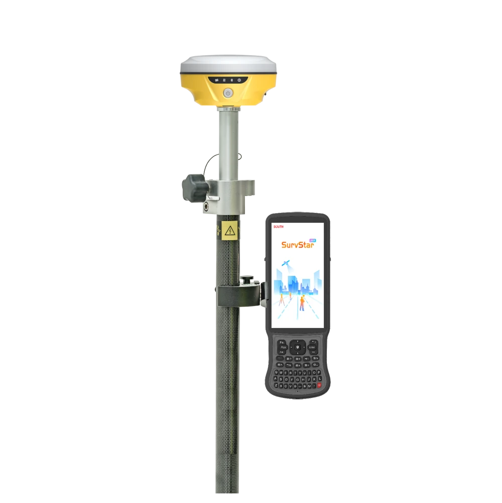
The South Insight V4 Rover Set is a complete compact RTK GNSS surveying kit for surveyors, construction teams, engineers, GIS users and drone mapping professionals. It combines the South Insight V4 visual RTK receiver with a South H9 data collector, SurvStar field software, telescopic pole and controller bracket, giving field crews a ready-to-use rover setup for accurate measurement and stakeout work.
With 1698 GNSS channels, dual-camera AR stakeout, 60° IMU tilt compensation and optional visual positioning, this rover set helps users work faster on construction sites, roads, utilities, cadastral surveys and mapping projects where speed, portability and practical field guidance matter.
South Insight V4 Rover Set Highlights
| Set Contents | Insight V4 receiver, South H9 data collector, SurvStar software, telescopic pole and controller bracket |
|---|---|
| GNSS Channels | 1698 channels with GPS, GLONASS, Galileo, BeiDou, QZSS and SBAS support |
| IMU Tilt Compensation | Calibration-free IMU tilt measurement up to 60° |
| Camera Functions | Dual-camera AR stakeout with 8 MP visual positioning camera and 2 MP AR stakeout camera |
| Field Design | 540 g compact receiver with IP68 protection and up to 25 hours rover battery life |


Valued customers:


Find RTK Networks
Search NTRIP providers and connect to reliable RTK correction services.
Description
Complete visual RTK rover set for surveying and construction
The South Insight V4 Rover Set is a complete GNSS rover package designed for professional fieldwork. It includes the compact South Insight V4 RTK GNSS receiver, South H9 data collector, SurvStar field software, telescopic pole and controller bracket. This makes it a practical choice for surveyors, construction workers, engineers, GIS teams and drone pilots who need a ready-to-use RTK rover setup.
The set is built for daily measurement and stakeout tasks where portability, clear field guidance and reliable centimetre-level RTK positioning are important. It is suitable for construction layout, topographic surveys, road and infrastructure work, utility mapping, cadastral surveys, GIS data collection and ground control point measurement for drone mapping.
Compact Insight V4 receiver with strong GNSS tracking
The South Insight V4 receiver uses a 1698-channel GNSS board and supports major satellite constellations including GPS, GLONASS, Galileo, BeiDou, QZSS and SBAS. In real fieldwork, this helps the rover track more satellites and maintain a stronger solution when moving between open terrain, urban streets, tree lines and partially obstructed areas.
For field crews, stronger satellite tracking can reduce waiting time and make daily work smoother. This is especially useful when a jobsite has buildings, machinery, vegetation or other obstacles that can make GNSS positioning more difficult.
Dual-camera AR stakeout for faster layout work
The Insight V4 includes dual-camera AR stakeout, using front and downward-facing camera views to guide the user toward the target point, line or curve. Instead of relying only on numbers and arrows, the operator can follow visual guidance on the controller screen.
This is useful for construction staking, road layout, utility marking and general survey stakeout. It can also help less experienced users understand where to move, while still giving professional surveyors a faster and more intuitive way to work through many points on site.
60° IMU tilt compensation for difficult points
The built-in calibration-free IMU supports tilt measurements up to 60°. This allows the user to measure points without keeping the pole perfectly vertical every time. On a real jobsite, this helps when points are close to walls, fences, trenches, vehicles, materials, buildings or other obstacles.
IMU tilt compensation can save time during repeated measurements and stakeout work because the operator can keep moving instead of stopping constantly to level the pole. This is useful for surveyors and construction crews who need accurate results but also need to work efficiently.
Visual positioning for points that are hard to reach
The South Insight V4 supports visual positioning workflows for non-contact measurement. This allows users to measure points from images or video when it is unsafe, difficult or impractical to place the pole directly on the point.
For field teams, this is helpful near busy roads, water, excavations, blocked areas, rooftops, steep ground or other locations where direct occupation is not ideal. It gives surveyors and engineers more flexibility when collecting data in complex environments.
SurvStar field software included
The rover set includes SurvStar field software, giving users tools for RTK measurement, stakeout, mapping, CAD-based workflows, static and PPK measurement, visual positioning and data management. The software is designed to support practical field tasks without needing to return to the office for every drawing or layout change.
For construction and surveying teams, this means drawings, points and field data can be handled directly on the controller. Users can measure and draw in the field, stake out from CAD data, manage layers and export data for further office processing.
South H9 data collector for field operation
The included South H9 data collector gives the operator a dedicated controller for running SurvStar, managing projects and communicating with the receiver. A dedicated field controller is important for professional RTK work because it keeps the measurement workflow organized and gives users a practical interface for stakeout, mapping and data collection.
Combined with the telescopic pole and controller bracket, the rover set gives users a complete working configuration for everyday GNSS fieldwork.
Built for outdoor jobsite conditions
The Insight V4 receiver is compact and lightweight at around 540 g, making it easy to carry and comfortable to use during long days in the field. Its IP68 protection helps protect the receiver against dust and water, which is important for construction sites, road work, farms, forests, utility corridors and other outdoor survey environments.
The internal battery is designed for long rover operation, helping users complete full work sessions with fewer interruptions. This makes the set useful for teams that move between multiple sites or work in areas where charging options are limited.
Communication options for rover workflows
The South Insight V4 supports Bluetooth, Wi-Fi, NFC, Type-C connection and UHF communication in the 410–470 MHz range. As a rover set, it is suited for working with compatible RTK correction sources, base stations or correction networks depending on the user’s project setup.
The receiver also includes internal storage and supports common GNSS data formats for RTK, static and post-processing workflows. This gives surveyors flexibility when collecting field data and transferring it into office software.
Who should use the South Insight V4 Rover Set?
The South Insight V4 Rover Set is a good fit for professionals who want a compact RTK rover with modern visual tools. It is especially useful for land surveyors, construction layout crews, civil engineers, GIS teams, public works departments, utility mapping crews and drone pilots who need accurate ground control or additional ground measurements.
It is also a practical option for companies that want to equip field staff with a complete GNSS rover package instead of buying the receiver, controller, software and accessories separately. The combination of AR stakeout, IMU tilt compensation and visual positioning makes it easier to work quickly in both simple and more challenging field conditions.
Buying from Global GPS Systems
Global GPS Systems supplies the South Insight V4 Rover Set with worldwide delivery from the Netherlands and support from GNSS product specialists. This is useful for buyers who want help choosing the right RTK setup, correction workflow, controller, software and accessories for their surveying, construction, GIS or drone mapping work.
For teams comparing RTK GNSS rover sets, the South Insight V4 Rover Set offers a compact receiver, visual stakeout, tilt measurement and a complete field-ready configuration for accurate and efficient GNSS work.
Datasheets & Manuals
Datasheets and manuals
Specifications
South Insight V4 Rover Set Specifications
Product Overview
| Product Name | South Insight V4 Rover Set |
|---|---|
| Product Type | RTK GNSS rover set with visual positioning, IMU tilt compensation and AR stakeout |
| Receiver Model | South Insight V4 |
| Manufacturer | SOUTH Surveying & Mapping Instrument Co., Ltd. |
| Typical Applications | Land surveying, construction layout, engineering survey, cadastral survey, RTK rover work, PPK/static survey, AR stakeout, CAD stakeout, visual measurement and field data collection |
| GNSS Engine | SOUTH S805 |
| GNSS Channels | 1698 channels |
| Main Rover-Set Components | Insight V4 GNSS receiver, South H9 data collector, SurvStar software, telescopic pole and controller bracket |
| Key Features | Dual-camera visual positioning, dual-camera AR stakeout, 60° calibration-free IMU tilt compensation, dual-engine GNSS positioning algorithm, Farlink 2.0 radio, 3D modelling by video shooting and multiple data-processing workflows |
GNSS Signal Tracking
| GPS | L1C, L1C/A, L2C, L2P(Y), L5 |
|---|---|
| GLONASS | G1, G2, G3 |
| BeiDou / BDS | B1I, B2I, B3I, B1C, B2a, B2b |
| Galileo | E1, E5a, E5b, E6, AltBOC* |
| SBAS | L1* |
| IRNSS | L5* |
| QZSS | L1, L2C, L5* |
| MSS L-Band | Reserved for future upgrade* |
Positioning Performance
| Position Output Rate | 1 Hz to 20 Hz |
|---|---|
| Initialization Time | < 10 s |
| Initialization Reliability | > 99.99% |
| RTK Initialization Time | 2 s to 8 s |
| IMU Tilt Angle | 0° to 60° |
| SBAS Positioning | Typically < 5 m 3DRMS |
Positioning Accuracy
| Positioning Mode | Horizontal Accuracy | Vertical Accuracy |
|---|---|---|
| Code Differential Positioning | 0.25 m + 1 ppm RMS | 0.50 m + 1 ppm RMS |
| GNSS Static | 2.5 mm + 0.5 ppm RMS | 3.5 mm + 0.5 ppm RMS |
| Static, Long Observation | 2.5 mm + 0.1 ppm RMS | 3 mm + 0.4 ppm RMS |
| Rapid Static | 2.5 mm + 0.5 ppm RMS | 5 mm + 0.5 ppm RMS |
| PPK | 3 mm + 1 ppm RMS | 5 mm + 1 ppm RMS |
| RTK via UHF | 8 mm + 1 ppm RMS | 15 mm + 1 ppm RMS |
| RTK via NTRIP | 8 mm + 0.5 ppm RMS | 15 mm + 0.5 ppm RMS |
IMU, Cameras and Sensors
| IMU Module | Built-in calibration-free IMU module |
|---|---|
| IMU Tilt Compensation | Up to 60° |
| IMU Generation | 5th generation IMU |
| Visual Positioning Camera | 8 MP camera; can be used in AR stakeout |
| AR Stakeout Camera | 2 MP camera |
| Dual-Camera AR Stakeout | Supports front and bottom camera use for staking out points, lines and curves |
| Visual Positioning | Supports non-contact point measurement using photos or video |
| Remote Visual Measurement | Visual positioning can measure points up to 10 m or more in ideal conditions |
| 3D Modelling Support | Supports image and video data collection for 3D modelling workflows |
| Electronic Bubble | Controller software can display an electronic bubble and check pole levelling status in real time |
| Thermometer | Built-in thermometer sensor with intelligent temperature control for monitoring and adjusting receiver temperature |
Communication and Radio
| Internal UHF Radio | Internal UHF radio receiver and transmitter |
|---|---|
| UHF Frequency Range | 410 MHz to 470 MHz |
| UHF Protocols | Farlink, TrimTalk, SOUTH, HUACE, Hi-Target, Satel |
| Farlink Communication Range | Typically 8 km with Farlink protocol; up to 10 km to 12 km in ideal conditions with Farlink 2.0 |
| Farlink 2.0 Functions | Higher data handling, more stable transmission and lock-base function for receiving corrections from a specific base |
| Bluetooth | Bluetooth 3.0 / 4.1 standard; Bluetooth 2.1 + EDR |
| NFC | Supported |
| Wi-Fi / Web Connection | Web UI access via Wi-Fi or USB connection |
| Internet Modem | None listed on the Global GPS Systems rover-set page |
| NTRIP Support | Fully supports NTRIP protocol |
| Network Models | VRS, FKP, MAC |
Data Storage, Transmission and Formats
| Internal Storage | 16 GB SSD internal storage |
|---|---|
| Storage Mode | Automatic cycling storage |
| External Storage | Supports external USB storage via OTG |
| Sample Interval | Customizable up to 20 Hz |
| USB Data Transmission | Plug-and-play USB data transmission |
| Remote Data Download | Supports FTP and HTTP data download |
| Static Data Formats | STH, RINEX 2.01, RINEX 3.02 and others |
| Differential Data Formats | RTCM 2.1, RTCM 2.3, RTCM 3.0, RTCM 3.1, RTCM 3.2 |
| GNSS Output Data Formats | NMEA 0183, PJK plane coordinate, binary code |
| Network Data Support | VRS, FKP, MAC and NTRIP |
User Interface and Software
| Receiver Operating System | Linux |
|---|---|
| Receiver Buttons | Single button |
| Receiver Indicators | Power, Bluetooth, data and satellite indicators |
| Web Interface | Receiver status monitoring and configuration via Web UI using Wi-Fi or USB connection |
| Voice Guidance Languages | Chinese, English, Korean, Spanish, Portuguese, Russian, Turkish, French, Italian |
| Field Software | SurvStar software |
| Field Controller | South H9 data collector included in the rover set |
| Secondary Development | Provides secondary development package; opens OpenSIC observation data format and interaction interface definition |
| Cloud Service | Supports online services such as remote management, firmware updates and online registration |
Field Workflow Features
| Dual-Engine GNSS Algorithm | Two positioning algorithms are available; Enhanced Positioning Mode can be used in SurvStar when VRS RTK accuracy is affected by active ionospheric conditions |
|---|---|
| AR Stakeout | AR guide lines in the controller app guide the user toward target points, lines and curves |
| Live-View Stakeout | Uses front and bottom camera imagery to assist stakeout from longer range and close range |
| Visual Measurement | Coordinates can be obtained from photos or videos, including points that are difficult or unsafe to access directly |
| 3D Modelling Workflow | Image and video data can supplement UAV or ground modelling data and support 3D modelling workflows |
| Measure and Draw | Supports selecting preset figures before measurement and automatically connecting measured points into drawings |
| CAD Drawing and Stakeout | Supports CAD drawing and CAD stakeout workflows in the field; DXF or DWG maps can be used in office workflows |
| Area Division | Supports selecting polygon points and directly identifying area-division points for stakeout |
| Static and PPK Measurement | Supported through SurvStar and compatible post-processing workflows |
| Robotic Total Station Integration | SOUTH manufacturer page states Insight V4 can integrate with robotic total station workflows for Prism Plus Position applications |
Hardware and Environmental
| Receiver Dimensions | 105 mm diameter × 58 mm height |
|---|---|
| Receiver Weight | 540 g, battery included |
| Housing Material | Magnesium aluminium alloy shell |
| Operating Temperature | -45°C to +75°C |
| Storage Temperature | -55°C to +85°C |
| Humidity | 100% non-condensing |
| Ingress Protection | IP68 |
| Water Protection | Protected from long-time immersion to a depth of 1 m |
| Dust Protection | Fully protected against blowing dust |
| Shock / Drop Resistance | Withstands a natural 2 m pole drop onto cement ground |
Power and Battery
| External Power Supply | 6 V to 28 V DC with overvoltage protection |
|---|---|
| Internal Battery | Built-in 5000 mAh rechargeable lithium-ion battery |
| Battery Life | Up to 25 h in rover mode under controlled testing conditions |
| Charging / Data Interface | USB Type-C interface |
| Battery Life Note | Actual battery life varies depending on usage patterns and operating factors |
Ports and Interfaces
| I/O Port | Type-C interface for charging, OTG and Ethernet |
|---|---|
| UHF Antenna Interface | Supported |
| USB OTG | Supported |
| Ethernet | Supported through Type-C interface |
Package / Included Items
| Item | Quantity | Notes |
|---|---|---|
| South Insight V4 GNSS Receiver | 1 | Visual positioning RTK GNSS rover receiver |
| South H9 Data Collector | 1 | Field controller for data collection and receiver operation |
| SurvStar Software | 1 | Field software for surveying, mapping, stakeout and data-management workflows |
| Telescopic Pole | 1 | Survey pole for rover operation |
| Controller Bracket | 1 | Mounting bracket for attaching the data collector to the pole |
Notes and Configuration Variations
| Reserved / Upgrade Items | Items marked with an asterisk, including some satellite signals and MSS L-Band, are listed as reserved or subject to future upgrade |
|---|---|
| Accuracy Conditions | Measurement accuracy and operating range may vary due to atmospheric conditions, signal multipath, obstructions, observation time, temperature, satellite geometry and number of tracked satellites |
| Set Customization | The rover set accessories can be customized with compatible accessories depending on the required workflow and configuration |
| Specification Changes | Manufacturer specifications are subject to change without prior notice |
Specifications and package contents may vary by configuration, region or manufacturer update. Always check the current configuration before ordering.
FAQ
South Insight V4 Rover Set FAQ
Product Overview & Included Set
What is the South Insight V4 Rover Set?
The South Insight V4 Rover Set is a complete professional GNSS rover package for RTK surveying, construction layout, mapping, GIS data collection, and other high-accuracy field positioning tasks. It combines the compact South Insight V4 receiver with a controller, field software, pole, and mounting accessories for rover-based surveying workflows.
What is included in the South Insight V4 Rover Set?
The set includes the South Insight V4 GNSS receiver, South H9 data collector, SurvStar field software, telescopic pole, and controller bracket. The accessories create a practical rover setup for field measurement, stakeout, and data collection.
Who is this rover set designed for?
This rover set is designed for land surveyors, construction layout teams, civil engineers, GIS professionals, road and rail surveyors, utility mapping crews, infrastructure contractors, and field teams that need accurate RTK positioning in daily survey work.
Is this a rover-only set or a rover-base set?
This product is a rover set. It is intended to work as a GNSS rover with correction data from an RTK network, NTRIP service, compatible base station, or other correction source. It is not the same as a rover-base set that includes both a rover and a separate base receiver.
Can the accessories in the set be customized?
Yes. The telescopic pole, controller bracket, and other accessories can be adapted or replaced with compatible alternatives to match different field workflows, project types, or user preferences.
What types of work can I use the South Insight V4 Rover Set for?
The rover set can be used for RTK surveying, topographic surveys, construction layout, stakeout, GIS data collection, utility mapping, site documentation, static and PPK workflows, and visual measurement tasks where direct access to a point may be difficult.
Accuracy, GNSS & RTK Performance
How accurate is the South Insight V4 Rover Set?
The Insight V4 is designed for centimeter-level GNSS surveying. Published specifications list RTK UHF accuracy at 8 mm + 1 ppm horizontal and 15 mm + 1 ppm vertical, and RTK NTRIP accuracy at 8 mm + 0.5 ppm horizontal and 15 mm + 0.5 ppm vertical under suitable field and correction conditions.
How many GNSS channels does the receiver have?
The South Insight V4 has 1698 channels. This helps the receiver track more satellite signals and improves fixed-solution performance in demanding environments such as dense vegetation, urban areas, and locations with weaker GNSS signals.
Which satellite constellations does the South Insight V4 support?
The receiver supports multiple GNSS constellations and signals, including GPS, GLONASS, Galileo, BeiDou, QZSS, SBAS, and IRNSS/NavIC signal support depending on signal availability and configuration.
How quickly can the rover obtain an RTK fixed solution?
The Insight V4 is specified with an RTK initialization time of approximately 2 to 8 seconds under suitable conditions. Actual performance depends on satellite visibility, correction quality, environment, and workflow setup.
Does the South Insight V4 Rover Set work in difficult GNSS environments?
Yes. The receiver is designed to improve performance in weak-signal environments such as dense forest, urban areas, and sites surrounded by buildings. Its 1698-channel GNSS board and dual-engine positioning algorithms help maintain reliable positioning where conditions are more challenging.
What is dual-engine GNSS positioning?
Dual-engine GNSS positioning means the receiver can use two positioning algorithms. When VRS RTK positioning becomes less reliable, for example during ionospheric disturbance, users can enable Enhanced Positioning Mode in SurvStar to help correct errors in real time and improve measurement reliability.
IMU Tilt, AR Stakeout & Visual Functions
What is IMU tilt compensation on the South Insight V4?
IMU tilt compensation allows users to measure accurately even when the survey pole is not perfectly vertical. This improves speed and flexibility when measuring beside walls, fences, trees, slopes, trenches, traffic areas, or other obstacles.
What tilt angle does the South Insight V4 support?
The South Insight V4 supports IMU tilt compensation up to 60°. This allows surveyors to measure more efficiently in situations where keeping the pole vertical is difficult or unsafe.
What is dual-camera AR stakeout?
Dual-camera AR stakeout uses the receiver’s front and bottom cameras together with the controller app to provide visual guidance during stakeout. The system can guide users toward points, lines, and curves using augmented reality instructions on the screen.
Can the South Insight V4 stake out points, lines, and curves?
Yes. The receiver supports AR stakeout for points, lines, and curves, making it easier to navigate to the correct position during construction layout, boundary work, and other stakeout tasks.
What is visual positioning?
Visual positioning is an optional image-based measurement function that can obtain coordinates from photos or video. It helps users measure points that are inaccessible, unsafe, obstructed, or difficult to reach directly with the pole.
Does the South Insight V4 support 3D modeling?
Yes. 3D modeling is available as an optional workflow. Image data from the Insight V4 can be used to help produce geographic information such as coordinates, areas, and volumes, and can be integrated into SOUTH software or compatible third-party modeling software.
Connectivity, Software & Field Durability
Does the South Insight V4 Rover Set have a built-in internet modem?
The listed configuration does not include a built-in internet modem. For NTRIP or internet-based RTK correction services, users typically need a compatible controller, phone, tablet, or other external internet connection.
Does the rover support UHF radio?
Yes. The South Insight V4 supports UHF radio in the 410–470 MHz range. The datasheet lists the internal UHF as receive-only, making it suitable for receiving correction data from a compatible base station or correction source.
What connectivity options are available?
The receiver supports Bluetooth, NFC, Wi-Fi or USB web access, Type-C connection, UHF antenna connection, USB data transfer, and FTP or HTTP data download depending on the workflow and configuration.
What can the SurvStar software be used for?
SurvStar is used for field data collection, RTK surveying, stakeout, AR guidance, mapping, project management, and GNSS measurement workflows. It helps connect the South H9 data collector with the Insight V4 receiver for practical field operation.
How durable is the South Insight V4 receiver?
The receiver has a magnesium-aluminum alloy shell, IP68 dust and water protection, 100% non-condensing humidity tolerance, and is specified to withstand a natural 2 m pole drop onto concrete. It is built for demanding outdoor field conditions.
How long does the battery last?
The Insight V4 has an integrated 5000 mAh rechargeable lithium-ion battery and is specified for up to 20 hours of battery life in rover mode, depending on field conditions, settings, and usage.
How much storage does the receiver have?
The South Insight V4 includes 16 GB of internal storage and supports automatic cycling storage. It can also support external USB storage through OTG for compatible data workflows.
Reviews (0)
Only logged in customers who have purchased this product may leave a review.


Reviews
There are no reviews yet