

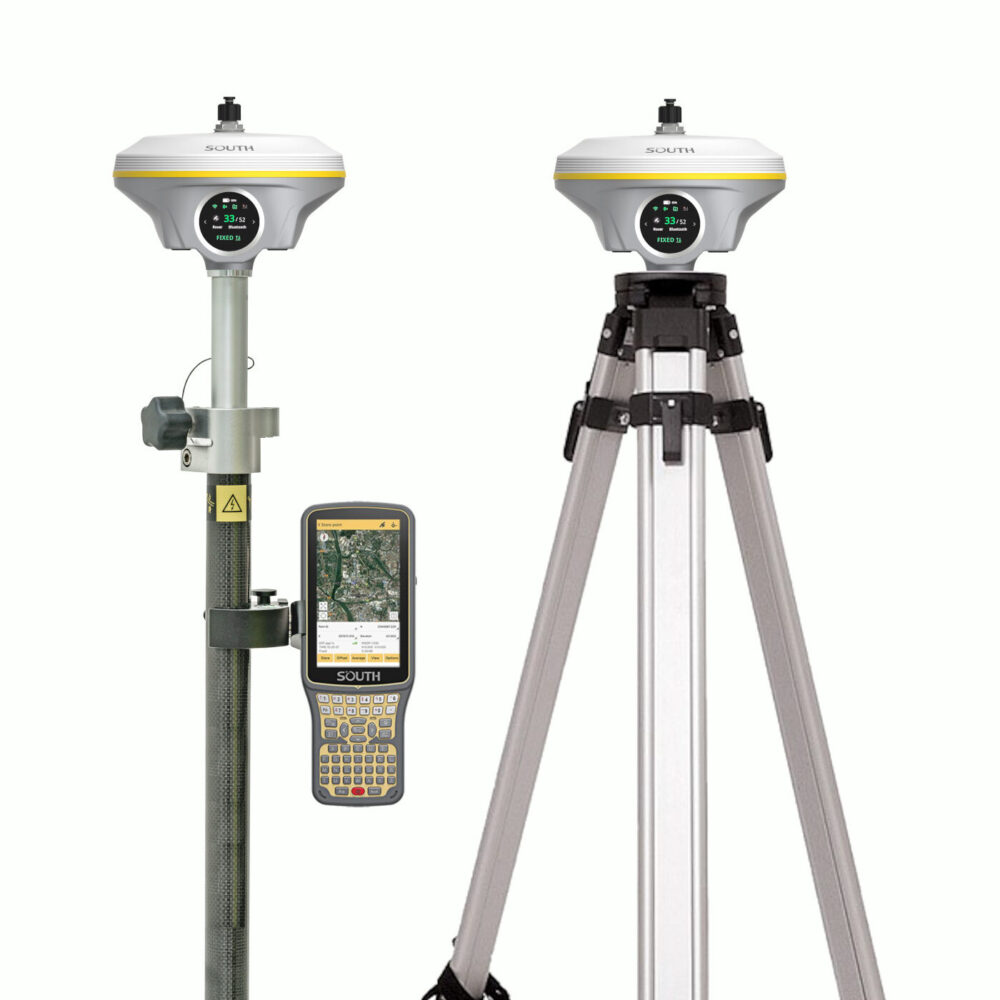


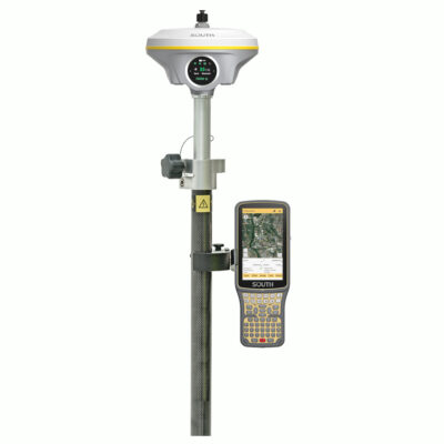
South INNO8 Rover Base Set with Visual RTK and IMU Tilt
This product is available
Get the best price for your setup
Contact our experts for the best possible price and configuration.
The South INNO8 Rover Base Set is a complete RTK GNSS solution for surveyors, construction teams, GIS users and drone mapping professionals who need accurate positioning in demanding field conditions. With visual positioning, AR stakeout, 60° IMU tilt compensation, 4G, UHF radio and Farlink 2.0, it helps you measure, stake out and collect data faster with fewer blind spots.
South INNO8 Rover Base Set Highlights
| GNSS Channels | Up to 1760 channels |
|---|---|
| Visual Positioning | 8 MP camera with image and video based measurement |
| IMU Tilt | 60° tilt compensation with fast initialization |
| Stakeout | AR stakeout with live view guidance |
| Communication | 4G, WiFi, Bluetooth, NFC and UHF radio 410 to 470 MHz |
Valued customers:


Find RTK Networks
Search NTRIP providers and connect to reliable RTK correction services.
Description
South INNO8 Rover Base Set for RTK surveying and construction layout
The South INNO8 Rover Base Set is built for professionals who need a flexible RTK GNSS system for land surveying, construction layout, mapping, utility work, road projects and drone supported workflows. It combines a high performance GNSS receiver with visual positioning, AR stakeout and IMU tilt compensation, giving field crews more ways to measure points that are difficult, unsafe or time consuming to reach with a standard pole setup.
For surveyors and construction teams, the main advantage is practical speed. The INNO8 can be used as a conventional RTK rover, but it also supports image based measurement. This means you can capture photos or video from a suitable position and derive coordinates for points that may be under roofs, near obstacles, beside traffic, close to water or in areas affected by multipath. In real fieldwork, this can reduce the need to physically place the pole on every point.
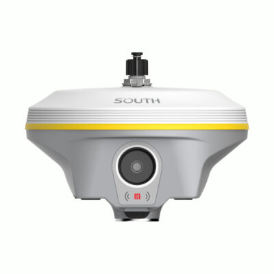
Visual positioning for hard to reach points
The INNO8 uses an 8 megapixel camera together with RTK positioning and IMU data to support visual measurement. This is useful on construction sites, urban surveys, excavation areas, utility surveys and roadside jobs where some points are blocked, unsafe or simply awkward to access. Instead of forcing the crew to stand directly on every feature, visual positioning can help collect coordinate data from images or videos while working from a safer and more convenient location.
This function is especially useful for surveyors who regularly work around buildings, bridges, trees, traffic, rivers, trenches or other obstacles. It also gives drone pilots and photogrammetry teams a ground based way to fill gaps in UAV models, capture extra detail and support 3D modelling workflows.
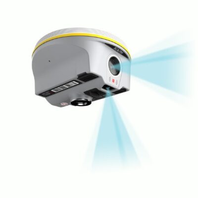
AR stakeout for easier layout work
AR stakeout gives the operator real scene guidance on the controller display. Instead of relying only on a compass style direction screen, the user can follow visual guidance to the target point. This makes stakeout easier for less experienced users and helps experienced crews work more comfortably when setting out points, lines and curves.
For construction layout, this can make daily work more intuitive. Crews can move toward the design point with clearer direction, reducing confusion on busy sites where many points, offsets and reference marks are being used at the same time.
60 degree IMU tilt compensation
The South INNO8 includes IMU tilt compensation up to 60 degrees. In practice, this allows users to measure points without carefully levelling the pole every time. That is a major advantage when working beside walls, fences, slopes, stockpiles, curbs, trenches or other locations where holding the pole perfectly vertical is difficult.
The fast IMU initialization helps keep fieldwork moving. For everyday RTK surveying, this means fewer delays, less repeated setup and more comfortable point collection during long days outside.
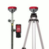
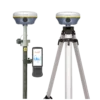
Base and rover flexibility with 4G and UHF
As a rover base set, the INNO8 is suitable for projects where you need your own local correction source instead of depending only on a correction network. The receiver supports 4G internet connectivity and UHF radio communication, making it useful for both network RTK and base rover operation. Farlink 2.0 is designed for stable long range radio correction transmission, which is helpful on larger sites where the base must cover a wider working area.
This flexibility is valuable for survey companies, contractors and mapping teams that move between different job sites. On some projects you may use a CORS or VRS network. On others, especially remote areas or sites with unreliable mobile coverage, a local base and rover setup can be the better choice.
Built for survey, construction, GIS and drone workflows
The South INNO8 is suitable for control surveys, topographic mapping, road and highway work, construction staking, utility mapping, volume surveys, GIS data collection and UAV support. It is also relevant for teams that want more than standard RTK point collection, because the receiver can support visual measurement, image data, point clouds and 3D modelling workflows depending on the software setup.
For drone pilots, the INNO8 can help capture ground details that aerial photogrammetry may miss. For GIS workers, it offers accurate field data collection with modern connectivity. For construction workers and site engineers, the AR stakeout and tilt functions help make layout tasks more understandable and less dependent on perfect pole handling.
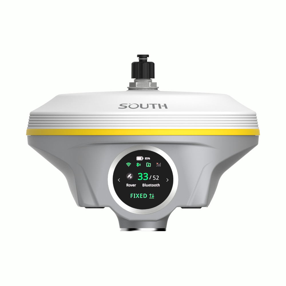
Simple receiver operation in the field
The receiver includes a colour touch screen for quick access to receiver status, work modes and data link settings. This makes it easier to check the receiver without always relying on a controller. Web UI access through WiFi or USB also allows configuration, monitoring and receiver management when needed.
The Type C charging and internal battery design keep the system practical for daily field use, while NFC, Bluetooth, WiFi, 4G and UHF options provide several ways to connect the receiver into different workflows.
Who is the South INNO8 Rover Base Set for?
This rover base set is a strong choice for land surveyors who want advanced RTK features, construction teams that need efficient stakeout, GIS professionals collecting accurate field data and drone mapping users who need ground based measurement support. It is also suitable for companies replacing older GNSS sets with a modern receiver that adds visual positioning and AR assisted workflows.
Global GPS Systems supplies the South INNO8 Rover Base Set with product knowledge and support for international buyers. This helps customers choose the right configuration, understand software and accessory options, and match the system to the type of RTK work they perform in the field.
Datasheets & Manuals
Datasheets and manuals
Specifications
South INNO8 Rover Base Set Specifications
Product Overview
| Product Type | RTK GNSS rover and base set |
|---|---|
| Brand | South |
| Model | INNO8 |
| Release Year | 2024 |
| Typical Applications | Land surveying, construction layout, cadastral surveying, mapping, RTK measurement, PPK/static data collection, visual positioning, AR stakeout, photogrammetry, 3D modelling support, and UAV survey data supplementation |
| Main Functions | GNSS RTK positioning, base/rover operation, photogrammetry measurement, AR stakeout, IMU tilt compensation, static and PPK measurement, UHF RTK, network RTK, Wi-Fi data link, and visual data collection |
| Receiver Channel Options | 1598, 1698, or 1760 channels depending on configuration |
| Operating System | Embedded Linux |
GNSS Signal Tracking
| GNSS Version | Supported Signals | MSS / L-Band |
|---|---|---|
| 1598 Channels | GPS L1, L1C, L2C, L2P, L5; GLONASS L1C/A, L1P, L2C/A, L2P, L3; BDS-2 B1I, B2I, B3I; BDS-3 B1I, B3I, B1C, B2a, B2b; Galileo E1, E5A, E5B, E6C, AltBOC; SBAS WAAS/MSAS/EGNOS/GAGAN L1; IRNSS L5; QZSS L1, L2C, L5 | BDS-PPP, Galileo HAS |
| 1698 Channels | GPS L1, L1C, L2C, L2P, L5; GLONASS G1, G2, G3; BDS B1I, B2I, B3L, B1C, B2A, B2B; Galileo E1, E5A, E5B, E6C; SBAS WAAS/MSAS/EGNOS/GAGAN L1C, L1A; NavIC/IRNSS L5; QZSS L1, L2C, L5 | Reserve |
| 1760 Channels | GPS L1C/A, L1C, L2C, L2P, L5; GLONASS L1C/A, L2C/A, L2P, L3CDMA; BDS B1I, B1C, B2I, B2a, B3; Galileo E1, E5A, E5B, E5AltBOC, E6; SBAS EGNOS, WAAS, GAGAN, MSAS, SDCM L1/L5; NavIC L5; QZSS L1C/A, L1C, L2C, L5, L6 | BDS-PPP, Galileo HAS |
GNSS Performance
| Initialization Time | <10 seconds |
|---|---|
| Initialization Reliability | >99.99% |
| Positioning Output Rate | 1 Hz to 20 Hz |
| RTK Initialization Time | 2 to 8 seconds |
| SBAS Positioning | Typically <5 m 3DRMS |
| Network RTK Support | VRS, FKP, MAC, and full NTRIP protocol support |
Positioning Accuracy
| Mode | Horizontal Accuracy | Vertical Accuracy |
|---|---|---|
| Code Differential GNSS | 0.25 m + 1 ppm RMS | 0.50 m + 1 ppm RMS |
| Static, Long Observations | 2.5 mm + 0.1 ppm RMS | 3 mm + 0.4 ppm RMS |
| Static | 2.5 mm + 0.5 ppm RMS | 3.5 mm + 0.5 ppm RMS |
| Rapid Static | 2.5 mm + 0.5 ppm RMS | 5 mm + 0.5 ppm RMS |
| PPK | 3 mm + 1 ppm RMS | 5 mm + 1 ppm RMS |
| RTK UHF | 8 mm + 1 ppm RMS | 15 mm + 1 ppm RMS |
| RTK NTRIP | 8 mm + 0.5 ppm RMS | 15 mm + 0.5 ppm RMS |
| BDS-PPP | 10 cm | 20 cm |
| Galileo HAS | 20 cm | 40 cm |
IMU Tilt Compensation
| IMU Generation | 4th generation IMU |
|---|---|
| IMU Update Rate | 200 Hz |
| Tilt Angle | 0° to 60° |
| Initialization Method | Shake or walk |
| Calibration | Calibration-free |
| Magnetic Interference Resistance | IMU operation is designed to ignore magnetic interference during RTK receiver use |
Visual Positioning, Cameras and AR Stakeout
| Visual Positioning | Supports image-based coordinate measurement using photos or video |
|---|---|
| Visual Positioning Camera | 8 MP |
| AR Stakeout Camera | 2 MP |
| AR Stakeout Camera Visual Angle | 75° |
| AR Stakeout Functions | Live-view guidance for point, line, curve and CAD stakeout depending on software workflow |
| Image Processing Modes | Cloud server online processing, desktop software post-processing, and data-controller offline processing |
| Online Image Measurement Accuracy | Up to 2 cm under suitable conditions |
| Offline Controller Processing Accuracy | Up to 4 cm results within approximately 30 seconds under suitable conditions |
| 3D Modelling Support | Supports use of INNO8 image measurement results for 3D modelling and integration with UAV survey data |
User Interface and Software
| Touch Screen | HD 1.39-inch colour circular touch screen |
|---|---|
| Keys | Power key |
| LED Indicator | Power indicator |
| Voice Guidance | Supported |
| Supported Languages | Chinese, English, Korean, Russian, Spanish, Portuguese, Turkish, French, and Italian |
| Web UI | Supported via Wi-Fi and USB connection for receiver monitoring and configuration |
| Cloud Service | Supports online services such as remote management, firmware update, and online registration |
| Secondary Development | Provides secondary development package and OpenSIC observation data format/interface definition |
| Field Software | SurvStar survey software |
| Office Software Support | SOUTH Geo Office (SGO) for GNSS data processing, reporting, RINEX import/export, RTK/PPK checking, and 3D modelling support |
Communication and Data Links
| Internal UHF Radio | Integrated radio receiver and transmitter |
|---|---|
| UHF Power Levels | 1 W, 2 W, and 5 W |
| UHF Frequency Range | 410 MHz to 470 MHz |
| Radio Protocols | Farlink, SOUTH, TrimTalk, Hi-Target, and CHC |
| Radio Modes | Radio receiver/transmitter, radio router, and radio repeater |
| Farlink Range | Typically 8 km to 15 km; up to 20 km to 25 km under optimal conditions |
| Wi-Fi | 802.11 b/g/n; AP mode and client mode supported |
| Cellular Modem | Integrated 4G LTE modem |
| LTE Bands | FDD B1, B2, B3, B4, B5, B7, B8, B20 |
| 3G / 2G Support | DC-HSPA+, HSPA+, HSPA, UMTS B1/B2/B5/B8, EDGE/GPRS/GSM 850/900/1800/1900 MHz |
| Bluetooth | Bluetooth 4.0 standard and Bluetooth 2.1 + EDR |
| NFC | Automatic pairing between receiver and controller when the controller supports NFC wireless communication |
| Supported Data Link Modes | Internal UHF, cellular network, external radio, dual transmit, Bluetooth/controller network, Wi-Fi data link, intelligent data link, and no data link |
Ports and Connectivity
| 5-Pin LEMO Port | External power port and RS232 |
|---|---|
| USB / Charging Port | Type-C for charging, USB, OTG, and Ethernet |
| UHF Antenna Interface | Supported |
| SIM Card Slot | Supported for cellular network operation |
Data Storage and Formats
| Internal Storage | 64 GB SSD internal storage |
|---|---|
| Storage Management | Automatic cycle storage |
| External Storage | Supports external USB storage |
| Sample Interval | Customizable sample interval up to 50 Hz |
| Static Data Formats | STH, RINEX 2.01, RINEX 3.02 and others |
| Differential Data Formats | RTCM 2.1, RTCM 2.3, RTCM 3.0, RTCM 3.1, RTCM 3.2 |
| GNSS Output Formats | NMEA 0183, PJK plane coordinate, and binary code |
| Data Transmission | Plug-and-play USB data transmission; FTP/HTTP data download supported |
| RINEX Conversion | SurvStar supports conversion of STH files to RINEX on compatible controller, tablet, or phone workflows |
Power and Battery
| External Power Input | 6 V to 18 V DC with overvoltage protection |
|---|---|
| Internal Battery | Built-in 7.4 V, 10000 mAh battery |
| Charging | USB Type-C with PD quick charge protocol |
| Battery Life – UHF Receive / Transmit | 10 to 12 hours at 5 W |
| Battery Life – Static | Up to 25 hours |
| Battery Life – Rover Data Collector Internet Mode | More than 20 hours |
Hardware and Environmental
| Dimensions | 155 mm diameter x 98.5 mm height |
|---|---|
| Weight | 1.2 kg |
| Housing Material | Magnesium-aluminium alloy shell |
| Operating Temperature | -45°C to +75°C |
| Storage Temperature | -55°C to +85°C |
| Humidity | 100% non-condensing |
| Ingress Protection | IP68 |
| Shock / Drop Resistance | Withstands 2 m pole drop onto cement ground naturally |
| Electronic Bubble | Controller software can display electronic bubble and check carbon pole levelling status in real time |
| Thermometer | Built-in thermometer sensor with intelligent temperature control technology for monitoring and adjusting receiver temperature |
Included Items
| Item | Quantity | Notes |
|---|---|---|
| South INNO8 GNSS RTK Receiver | 2 | Configured as rover and base receiver set |
| South H6 Data Collector | 1 | Field controller for survey operation and data collection |
| SurvStar Surveying Software | 1 | Field software for GNSS survey workflows |
| Receiver Charger | Included | For charging the receiver battery |
| Type-C Cable | Included | For charging and data connection |
| Hard Carry Case | Included | Transport and storage case |
| UHF Antenna | Included | For internal UHF radio operation |
| Survey Pole | 1 | Surveying pole for rover operation |
| Data Collector Bracket | 1 | Mounts the controller to the survey pole |
| Tripod | 1 | For base receiver setup |
| Tribrach | 1 | For precise base receiver setup |
| Adapter | 1 | For mounting and base setup |
Specifications and package contents may vary by configuration, region or manufacturer update. Always check the current configuration before ordering.
FAQ
South INNO8 Rover Base Set FAQ
Product Overview and Use Cases
What is the South INNO8 Rover Base Set?
The South INNO8 Rover Base Set is a complete RTK GNSS surveying system with two receivers: one used as a fixed base station and one used as a mobile rover. It is designed for accurate surveying, construction layout, mapping, stake-out, and field data collection.
Who is the South INNO8 Rover Base Set suitable for?
It is suitable for land surveyors, construction companies, civil engineers, infrastructure contractors, drone surveyors, utility mapping teams, agriculture specialists, mining teams, and other professionals who need accurate GNSS measurements in the field.
When should I choose a rover and base set instead of a rover-only set?
A rover and base set is useful when you want to work independently from an RTK network, NTRIP service, or mobile internet connection. It is especially practical for remote areas, private construction sites, large rural projects, quarries, and locations with unreliable network coverage.
What is included with the South INNO8 Rover Base Set?
The set includes the South INNO8 GNSS receivers for rover and base operation, along with essential field accessories such as a data collector, SurvStar surveying software, survey pole, data collector bracket, tripod, tribrach, and adapter. The exact package can be adjusted depending on the required workflow.
Can the South INNO8 be used for construction layout?
Yes. The South INNO8 is well suited for construction layout, point stake-out, line stake-out, CAD stake-out, terrain measurement, control point work, and general site positioning tasks.
Can this GNSS set be used for drone surveying?
Yes. The South INNO8 can be used to measure ground control points and supplement UAV survey data. Its image measurement and 3D modeling capabilities can also support workflows where ground-based data is combined with aerial survey results.
Accuracy, GNSS Performance and Corrections
What RTK accuracy can the South INNO8 achieve?
In RTK mode, the South INNO8 is designed for centimetre-level positioning. Typical listed RTK accuracy is 8 mm + 1 ppm horizontal and 15 mm + 1 ppm vertical with UHF corrections, and 8 mm + 0.5 ppm horizontal and 15 mm + 0.5 ppm vertical with NTRIP corrections.
How many GNSS channels does the South INNO8 have?
Depending on the version, the South INNO8 is available with 1598, 1698, or 1760 channels. This allows the receiver to track multiple satellite signals for reliable positioning in professional field applications.
Which satellite systems does the South INNO8 support?
The South INNO8 supports multiple GNSS constellations, including GPS, GLONASS, Galileo, BeiDou, QZSS, SBAS, and NavIC/IRNSS depending on the receiver version and signal configuration.
Can the South INNO8 work without mobile internet?
Yes. As a rover and base set, the base receiver can transmit correction data to the rover by UHF radio. This makes the system useful in areas where mobile internet or RTK network access is not available or not reliable.
Does the South INNO8 support NTRIP corrections?
Yes. The South INNO8 supports NTRIP-based correction workflows and can be used with network RTK services when internet coverage and correction access are available.
What is the UHF radio range of the South INNO8?
The South INNO8 has an internal UHF radio with a 410–470 MHz frequency range. With the Farlink protocol, the listed radio range is up to 15 km, although real field range depends on terrain, antenna setup, interference, power settings, and local radio regulations.
Does the South INNO8 support static and PPK surveying?
Yes. The South INNO8 supports static, rapid static, RTK, and PPK workflows. It can also record raw data and export standard formats such as RINEX for post-processing.
IMU Tilt, Visual Stakeout and Field Workflow
Does the South INNO8 have IMU tilt compensation?
Yes. The South INNO8 includes IMU tilt compensation up to 60 degrees. This allows users to measure points without keeping the survey pole perfectly level, which can improve speed and flexibility near walls, fences, trenches, slopes, and other obstacles.
Does the IMU require calibration?
The South INNO8 uses a calibration-free IMU that can be initialized by shaking or walking. It is also designed to be immune to magnetic interference, which helps maintain reliable tilt measurements in demanding field environments.
What is visual positioning on the South INNO8?
Visual positioning uses camera-based image data to help measure points and collect coordinates in the field. This can improve productivity when measuring details that are difficult to access directly with a survey pole.
Does the South INNO8 support AR stakeout?
Yes. The South INNO8 supports AR stakeout workflows when used with compatible software and camera functions. AR guide lines can help users find stakeout points more intuitively on the data collector display.
Can I stake out directly from CAD drawings?
Yes. With compatible SurvStar workflows, users can perform CAD stake-out without manually preparing separate point files. This can help reduce preparation time and make point, line, and geometry stake-out easier in the field.
Can the South INNO8 be used for 3D modeling?
Yes. The South INNO8 supports image measurement and 3D modeling workflows. Survey data can be used to create or supplement models, calculate areas and volumes, and support broader mapping and design workflows.
Software, Connectivity and Durability
What software is used with the South INNO8?
The set is commonly supplied with SurvStar field software for data collection, stake-out, CAD workflows, and GNSS field operations. South Geo Office can also be used for GNSS data processing and reporting workflows.
Does the South INNO8 have 4G, Wi-Fi and Bluetooth?
Yes. The South INNO8 supports 4G LTE, 3G WCDMA, 2G GPRS/GSM, Wi-Fi, Bluetooth, and NFC pairing, depending on the controller and configuration used.
Is the South INNO8 waterproof and dustproof?
Yes. The South INNO8 is listed with an IP68 waterproof and dustproof rating, making it suitable for demanding outdoor surveying and construction environments.
How rugged is the South INNO8 receiver?
The receiver has a magnesium-aluminium alloy shell and is designed according to MIL-STD-810G shock and vibration requirements. It is listed as able to withstand a natural 2 m pole drop onto cement ground.
How long does the South INNO8 battery last?
The receiver includes a built-in 7.4 V 10000 mAh battery with PD quick charging support. In rover data collector internet mode, the listed battery life is more than 20 hours.
Can I customize the controller, software, or accessories?
Yes. The rover base set can be configured around different workflow needs. For example, users may prefer a tablet instead of the included controller or may require different accessories depending on the project type, software preference, or field setup.
Videos
Reviews (0)
Only logged in customers who have purchased this product may leave a review.
Reviews
There are no reviews yet