
 GPS & GNSS
 Lidar scanning
 Total Station


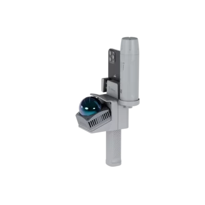


FJD Trion V4E LiDAR Kit Handheld 3D Scanner
This product is available
Get the best price for your setup
Contact our experts for the best possible price and configuration.
The FJD Trion V4E LiDAR Kit is a lightweight handheld 3D scanning solution for fast indoor and outdoor reality capture. It combines mobile LiDAR scanning with GNSS positioning to produce detailed, georeferenced point clouds for surveying, construction, BIM, utilities, forestry and asset documentation.
With real-time scan preview, a 360° horizontal field of view and up to 154,600 measured points per second, operators can move naturally through buildings, job sites and outdoor areas while checking coverage in the field. The compact system is designed to make professional 3D scanning more accessible without adding a complicated static-scanner setup to every project.
FJD Trion V4E LiDAR Kit Highlights
| Post-processed accuracy | 1 cm relative and 3 cm absolute |
|---|---|
| Point cloud output | Up to 154,600 points per second |
| Scanning range | Up to 50 m at 90% reflectivity |
| Field of view | 360° horizontal and 70° vertical |
| GNSS integration | Georeferenced outdoor point clouds |
| Operating time | At least 5 hours |

Valued customers:










Find RTK Networks
Search NTRIP providers and connect to reliable RTK correction services.
Description
Mobile LiDAR scanning for practical fieldwork
The FJD Trion V4E LiDAR Kit provides surveyors, engineers and construction teams with a portable way to capture complete 3D information while walking through a project area. Instead of setting up a conventional scanner at many separate positions, the operator can move continuously through rooms, corridors, structures and outdoor sites while the system records the surrounding geometry.
This makes the V4E well suited to projects where speed, mobility and straightforward operation are important. It can be used to document existing conditions, record construction progress, capture building interiors, map visible utilities, calculate volumes and create spatial records for later design or inspection work.
Detailed point clouds from a compact scanner
The LiDAR sensor produces up to 154,600 points per second, giving the system enough point density to capture walls, floors, structural elements, equipment and terrain during a normal walkthrough. Its 360° horizontal field of view records the environment around the operator, while the vertical scanning coverage helps capture surfaces above and below the scanner.
The maximum detection range is 50 metres on highly reflective surfaces and 25 metres on low-reflectivity targets. In practical terms, this gives users the flexibility to scan anything from compact indoor spaces to larger work areas, façades and open construction environments. Actual usable range and point quality will depend on the surface material, visibility and scanning conditions.
Georeferenced outdoor reality capture
When used with the V4E GNSS receiver, the LiDAR data can be positioned within real-world coordinates. This produces georeferenced point clouds that can be aligned with survey control, design information, site plans and other geospatial datasets.
GNSS integration is particularly useful for outdoor construction surveys, infrastructure documentation, stockpile capture, forestry work and site mapping. It reduces the manual work involved in moving an isolated scan into the correct coordinate system and makes the resulting dataset easier to combine with CAD, GIS and BIM workflows.
Useful accuracy for documentation and mapping
The V4E LiDAR offers post-processed point-cloud accuracy of approximately 1 cm relative and 3 cm absolute under suitable operating conditions. Relative accuracy describes how consistently objects are represented within the scan itself, while absolute accuracy indicates how closely georeferenced data matches its position in the selected coordinate system.
This level of performance makes the system suitable for many forms of site documentation, progress monitoring, volume measurement, floor-plan capture, asset recording and preliminary survey work. Users should still select the measurement method according to the tolerances and control requirements of the final deliverable.
Check scanning progress while still on site
The FJD Trion Scan App allows operators to preview the developing point cloud during data collection. Seeing the scan while walking helps identify missed areas, blocked surfaces or incomplete coverage before leaving the location. This can reduce return visits and gives less experienced operators more confidence that the required area has been recorded.
The system supports compatible iOS and Android devices. Once connected, the mobile device acts as the main field interface for starting scans, monitoring coverage and managing captured projects.
Designed for long scanning sessions
The main LiDAR unit weighs approximately 890 grams and provides at least five hours of operating time. Its compact form is useful in confined interiors, stairwells, industrial areas and active construction sites where larger equipment can be difficult to carry or position.
A 5/8-inch threaded mounting interface also provides flexibility when the scanner needs to be connected to suitable surveying or support equipment. The operating temperature range of −10°C to 60°C allows use across a broad range of normal indoor and outdoor working environments.
Applications across surveying and construction
The FJD Trion V4E LiDAR Kit can support a variety of reality-capture tasks, including:
- Existing-condition and as-built documentation
- Construction progress recording
- Scan-to-CAD and Scan-to-BIM workflows
- Building interior and façade capture
- Visible utility and infrastructure mapping
- Stockpile and earthwork volume measurement
- Forestry, terrain and environmental surveys
- Industrial asset and facility documentation
For construction workers and project teams, the main advantage is the ability to record a complete site quickly without operating a complex static scanning workflow. Surveyors and geospatial professionals can use the georeferenced output as part of broader measurement and mapping projects, while architects and BIM teams can turn the captured point clouds into usable records of existing structures.
From field scan to usable deliverables
Captured datasets can be processed in the FJD Trion software environment to create point clouds, meshes and files for further CAD or BIM work. Depending on the software configuration and project workflow, the same field dataset can support multiple deliverables rather than requiring the site to be captured again for each department.
Processing can be carried out locally or through supported cloud workflows. This gives teams options for reviewing data on site, completing more detailed office processing or sharing project information with colleagues and clients.
Choosing the correct V4E configuration
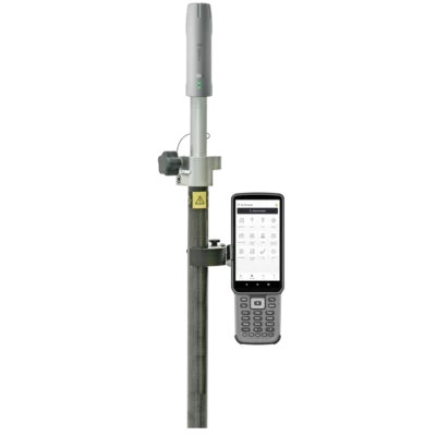
The best configuration depends on whether the work is mainly indoors, outdoors or a mixture of both. Indoor documentation may only require the LiDAR scanning setup, while outdoor projects that need coordinates should include the compatible V4E GNSS receiver and access to an appropriate RTK correction service or survey control workflow.
Global GPS Systems can help buyers select the appropriate hardware, software and accessories for their required accuracy, project size and final deliverables. This is especially useful for teams introducing mobile LiDAR for the first time or combining the system with an existing GNSS, CAD, GIS or BIM workflow.
Datasheets & Manuals
Datasheets and manuals
Datasheets & manuals
Specifications
FJD Trion V4e LiDAR Kit Specifications
Product Overview
| Product Type | Portable handheld LiDAR and SLAM 3D scanning system |
|---|---|
| Primary Function | Mobile 3D reality capture, point-cloud acquisition and digital site documentation |
| Scanning Environments | Indoor and outdoor environments |
| Scanning Method | Walk-through mobile scanning with SLAM-based positioning |
| Real-Time Monitoring | Real-time point-cloud preview and scan-coverage monitoring through the FJD Trion Scan application |
| Georeferenced Scanning | Supported when used with a compatible FJD Trion V4e GNSS receiver |
| Typical Applications | Surveying, construction, Scan-to-BIM, Scan-to-CAD, building documentation, infrastructure inspection, utility mapping, forestry, mining, digital twins, public safety and 3D modelling |
LiDAR Performance
| Laser Wavelength | 905 nm ± 5 nm |
|---|---|
| Laser Safety Classification | Class 1, IEC 60825-1:2014 |
| Sampling Rate | More than 200 kHz |
| Point-Cloud Output Rate | 154,600 points per second at 70° vertical field of view |
| Minimum Detection Distance | 0.05 m |
| Maximum Detection Range | 50 m at 90% target reflectivity |
| Detection Range at 10% Reflectivity | Up to 25 m |
| Horizontal Field of View | 360° |
| Vertical Field of View | -10° to 60° |
| Total Vertical Field of View | 70° |
Detection Range by Target Reflectivity
| Target Reflectivity | Detection Range | Minimum Distance |
|---|---|---|
| 90% Reflectivity | 0.05 to 50 m | 0.05 m |
| 10% Reflectivity | 0.1 to 25 m | 0.1 m |
Point-Cloud Accuracy
| Relative Post-Processed Accuracy | 1 cm |
|---|---|
| Absolute Post-Processed Accuracy | 3 cm |
| Georeferenced Output | Supported with a compatible GNSS receiver and applicable processing workflow |
| Coordinate Workflow | Outdoor scans can be aligned with real-world coordinates, plans and project layouts |
| Accuracy Conditions | Accuracy depends on scan geometry, operating environment, positioning quality, processing settings and field procedure |
Scanning and Capture Features
| SLAM Scanning | Supported |
|---|---|
| Mobile Walk-Through Capture | Supported |
| Real-Time Point-Cloud Visualisation | Supported through the FJD Trion Scan application |
| Scan-Coverage Preview | Supported during data acquisition |
| Colourised Point Clouds | Supported when used with a compatible smartphone camera and processing workflow |
| Indoor Scanning | Supported without GNSS reception |
| Outdoor Scanning | Supported, including georeferenced workflows with a compatible GNSS receiver |
| Typical Ready-to-Scan Time | Approximately 60 seconds under normal setup conditions |
Power and Battery
| Battery Type | Rechargeable lithium battery |
|---|---|
| Battery Voltage | 3.6 V |
| Battery Capacity | 6,700 mAh |
| Charging Input | 5 V / 3 A |
| Power Consumption | Less than 5 W at 25°C |
| Operating Time | At least 5 hours |
| Charging Time | 3 hours or less |
Ports and Interfaces
| Primary Data Port | USB 3.0 |
|---|---|
| Charging and Secondary Data Port | USB 2.0 |
| Firmware Updates | OTA over-the-air firmware update support |
| Smartphone Integration | Operated with a compatible smartphone running the FJD Trion Scan application |
| GNSS Integration | Compatible with an FJD Trion V4e RTK receiver for georeferenced scanning |
Physical Specifications
| Dimensions | 137 × 155 × 250 mm |
|---|---|
| Weight | Approximately 890 g |
| Mounting Interface | 5/8-inch internal threaded mount |
| Form Factor | Portable handheld scanning unit |
| Operating Temperature | -10°C to 60°C |
| Charging Temperature | 0°C to 45°C |
Mobile Device Compatibility
| Platform | Compatible Devices | Application |
|---|---|---|
| iOS | iPhone 15 and later models | FJD Trion Scan |
| Android | Samsung Galaxy S20 and later models | FJD Trion Scan |
Software and Processing
| Field Application | FJD Trion Scan |
|---|---|
| Desktop Processing Software | FJD Trion Model |
| Cloud Platform | FJD Trion Model Web |
| On-Site Processing | Supported on compatible mobile devices |
| Local Desktop Processing | Supported through FJD Trion Model |
| Cloud Processing and Collaboration | Supported through FJD Trion Model Web |
| Field Quality Control | Scan results and coverage can be reviewed before leaving the site |
| Data Sharing | Cloud-based sharing, review and team collaboration supported |
Supported Outputs
| 3D Point Clouds | Supported |
|---|---|
| Georeferenced Point Clouds | Supported with compatible GNSS equipment and processing workflow |
| Colourised Point Clouds | Supported |
| Mesh Generation | Supported through the FJD Trion software workflow |
| BIM-Ready Data | Supported through applicable processing and modelling workflows |
| CAD Workflow Data | Supported through Scan-to-CAD processing workflows |
| Digital Twins | Supported |
| 3D Gaussian Splatting | Supported through compatible processing workflows |
| Topographic and Mapping Outputs | Supported through compatible processing modules and georeferenced workflows |
| Volume and Stockpile Analysis | Supported through applicable FJD Trion Model workflows |
Deployment Configurations
| Handheld Operation | Supported |
|---|---|
| Smartphone-Mounted Operation | Supported with a compatible device and mounting accessory |
| GNSS-Assisted Operation | Supported with a compatible FJD Trion V4e RTK receiver |
| Pole or Tripod Mounting | Supported through the 5/8-inch threaded mounting interface |
| Indoor Configuration | LiDAR unit with compatible smartphone |
| Outdoor Georeferenced Configuration | LiDAR unit, compatible smartphone and compatible V4e GNSS receiver |
Industry Applications
| Land Surveying and Mapping | Mobile spatial-data acquisition and georeferenced point-cloud creation |
|---|---|
| Construction | Progress documentation, as-built capture, site verification and quantity workflows |
| Architecture and BIM | Existing-condition capture, Scan-to-BIM and building documentation |
| Infrastructure | Road, corridor, bridge, tunnel, utility and asset documentation |
| Utilities | Utility mapping, inspection and asset documentation |
| Mining and Quarries | Site mapping, stockpile measurement and volume analysis |
| Forestry and Agriculture | Terrain, vegetation and environmental data capture |
| Industrial Facilities | Plant documentation, equipment-layout capture and digital-twin creation |
| Public Safety | Scene documentation, accident investigation and emergency-response mapping |
| 3D Visualisation | 3D modelling, digital archiving and Gaussian Splatting content creation |
Configuration Notes
| Required Mobile Device | A compatible iOS or Android smartphone is required for mobile operation and live scan preview |
|---|---|
| GNSS Requirement | A separate compatible GNSS receiver is required for RTK-assisted georeferenced workflows unless included in the selected kit |
| Processing Requirement | Post-processed accuracy specifications require the applicable FJD Trion processing workflow |
| Software Licensing | Available functions, processing modules and export options may depend on the supplied software licence or subscription |
| Phone Compatibility | Compatibility should be confirmed against the current FJD Trion supported-device list before ordering |
| Package Configuration | Included hardware and accessories depend on the selected LiDAR-only, GNSS combination or dealer-specific kit configuration |
Specifications and package contents may vary by configuration, region or manufacturer update. Always check the current configuration before ordering.
FAQ
FJD Trion V4E LiDAR Kit FAQ
Product Overview and Applications
What is the FJD Trion V4E LiDAR Kit?
The FJD Trion V4E LiDAR Kit is a portable 3D mobile-mapping system designed to capture detailed point clouds while the operator walks through or around a site. It combines LiDAR measurement with SLAM technology and can be paired with the V4E Mini RTK receiver for georeferenced outdoor scanning.
Who is the FJD Trion V4E designed for?
It is designed for surveyors, construction professionals, BIM specialists, engineers, architects, utility teams, mining and quarry operators, forestry professionals, facility managers and other users who need fast 3D documentation of real-world environments.
Can the V4E LiDAR Kit be used indoors and outdoors?
Yes. The LiDAR unit can capture indoor areas where satellite positioning is unavailable, including offices, warehouses, industrial plants, basements and underground spaces. For outdoor projects requiring real-world coordinates, it can be combined with the V4E Mini RTK receiver.
What projects can the V4E LiDAR Kit be used for?
Typical applications include measured building surveys, Scan-to-BIM, as-built documentation, construction progress monitoring, topographic mapping, façade capture, utility and infrastructure surveys, stockpile calculations, forestry analysis, industrial documentation and digital-twin creation.
Can the V4E be used for Scan-to-BIM projects?
Yes. The scanner can capture existing buildings and structures as dense 3D point clouds. The processed data can then support the creation of BIM-ready models, floor plans, sections, elevations and as-built documentation in compatible third-party design software.
Can the scanner create digital twins and 3D models?
Yes. Captured data can be processed into point clouds, meshes and other 3D deliverables for digital twins, asset documentation, design coordination and visualisation. The data can also support 3D Gaussian Splatting workflows.
Accuracy and Scanning Performance
What accuracy does the FJD Trion V4E LiDAR provide?
The manufacturer specifies post-processed point-cloud accuracy of approximately 1 cm relative and 3 cm absolute. Actual project accuracy depends on the scanning route, environment, surface properties, GNSS quality, control data and processing method.
What is the scanning range of the V4E LiDAR?
The specified detection range is up to 50 metres on surfaces with 90% reflectivity and up to 25 metres on surfaces with 10% reflectivity. Dark, glossy, transparent or highly reflective materials may produce shorter ranges or incomplete data.
How many points per second does the scanner capture?
The V4E outputs up to 154,600 points per second across its 70-degree vertical field of view. This enables the scanner to record dense spatial data during a continuous walkthrough.
What is the field of view of the V4E LiDAR?
The scanner has a 360-degree horizontal field of view and a vertical field of view from approximately -10 degrees to 60 degrees. This allows surrounding walls, structures, floors and overhead features to be captured as the operator moves.
Can scan progress be viewed in real time?
Yes. The FJD Trion Scan app provides a real-time point-cloud preview while scanning. This helps the operator identify missing areas and confirm coverage before leaving the site.
What factors can affect LiDAR scan quality?
Scan quality can be affected by rapid or irregular movement, limited overlap, long featureless corridors, moving objects, reflective glass, dark surfaces, heavy vegetation, poor GNSS reception and an open scanning route that does not return to previously captured features. Careful route planning and verification improve reliability.
RTK, Smartphones and Field Operation
Does the V4E LiDAR require an RTK receiver?
No. The LiDAR unit can be used with a compatible smartphone for indoor and local-coordinate scanning. The V4E Mini RTK receiver is used when an outdoor point cloud must be connected to geographic or project coordinates. Confirm the exact components included in the selected package before ordering.
What is a georeferenced point cloud?
A georeferenced point cloud is positioned in a real-world or project coordinate system. This allows the scan to align with survey control, maps, engineering drawings, GIS information and other spatial datasets.
Which smartphones are compatible with the V4E LiDAR?
The published compatibility specification lists iPhone 15 and later models and Samsung Galaxy S20 and later models. Compatibility can change as the app and mobile operating systems are updated, so the current supported-device list should be checked before use.
Does the smartphone need its own LiDAR sensor?
No. The V4E uses its dedicated LiDAR unit to measure 3D geometry. The smartphone runs the scanning app, displays progress and can assist with image or colour capture depending on the selected workflow.
How long does the V4E LiDAR battery last?
The LiDAR unit is specified for at least five hours of operation under normal conditions. Runtime can vary with temperature, battery condition, connection settings and operating workload.
How long does the LiDAR unit take to charge?
The specified charging time is three hours or less when a suitable 5 V, 3 A power supply is used. Charging should take place within the specified temperature range of 0°C to 45°C.
Software, Processing and Data
Which software is used with the FJD Trion V4E?
FJD Trion Scan is used for connecting to the hardware, collecting data and viewing scan progress. FJD Trion Model is used for point-cloud processing and the creation of project deliverables. Web-based tools can support sharing, review and collaboration.
Can scans be processed while still on site?
Yes. Supported workflows allow users to process or review data on a compatible mobile device or tablet while on site. This can help confirm that the required area has been captured before the team leaves.
Can V4E data be processed locally?
Yes. FJD Trion supports local processing as well as mobile and web-based workflows. The appropriate option depends on project size, available hardware, connectivity, collaboration requirements and data-security policies.
What deliverables can be created from a V4E scan?
Depending on the software workflow, captured data can be used to create point clouds, meshes, BIM-ready files, topographic information, floor plans, sections, elevations, volume calculations, inspection records, asset documentation and digital-twin content.
Can the scan data be used in third-party CAD, BIM or GIS software?
Processed point-cloud and model exports can be used in compatible CAD, BIM, GIS and point-cloud applications. Before starting a project, confirm that the required export format is supported by both FJD Trion Model and the receiving software.
Can scans be shared with colleagues or clients?
Yes. Point clouds can be uploaded to the FJD Trion web platform for browser-based viewing, project management, review and collaboration. Data can also be exported for delivery through the organisation’s normal file-sharing system.
Reviews (0)
Only logged in customers who have purchased this product may leave a review.

 GPS & GNSS
 Total Stations
 Data collectors
 Software
 Correction services
 Machine control
 External radio
 Lasers & levellers
 Marine
 Accessories
Reviews
There are no reviews yet