


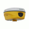
South ALPS2 Rover Set Laser RTK GNSS with Camera IMU
This product is available
Get the best price for your setup
Contact our experts for the best possible price and configuration.
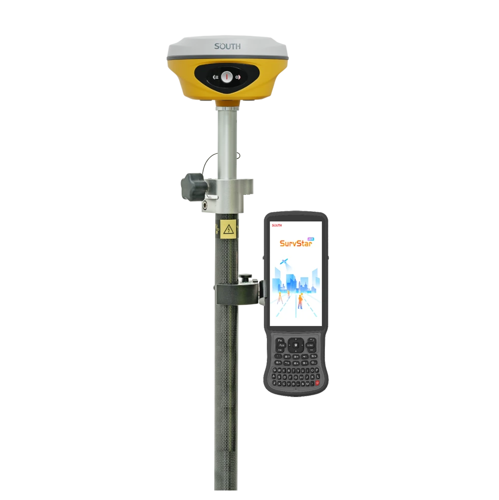
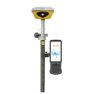
The South ALPS2 Rover Set is a complete RTK GNSS field kit for surveyors, construction crews, GIS teams and engineers who need accurate positioning with modern laser, camera and IMU workflows. It includes the ALPS2 receiver, South H9 data collector, SurvStar software, telescopic pole and controller bracket, giving field teams the main components needed for rover-based RTK work.
With laser measurement, dual-camera AR stakeout and IMU tilt compensation, this rover set helps users measure and stake points near walls, traffic, trenches, fences, building corners and other areas where placing a pole directly on the point is difficult or unsafe.
South ALPS2 Rover Set Highlights
| Rover Set Contents | ALPS2 receiver, South H9 data collector, SurvStar software, telescopic pole and controller bracket |
|---|---|
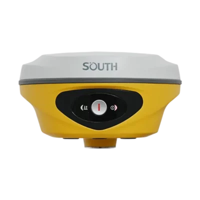
| Laser Measurement | 3R green laser with up to 30 m working range |
| Visual Stakeout | 8 MP front camera and 2 MP bottom camera for live-view AR stakeout |
| IMU Tilt | Calibration-free IMU tilt compensation for faster point collection |
| GNSS Channels | 1698 channels with GPS, GLONASS, BeiDou, Galileo, SBAS, IRNSS and QZSS support |
| RTK Accuracy | 8 mm + 1 ppm horizontal and 15 mm + 1 ppm vertical via UHF RTK |
| Field Durability | IP68 waterproof and dustproof housing with 2 m pole-drop resistance |


Valued customers:


Find RTK Networks
Search NTRIP providers and connect to reliable RTK correction services.
Description
South ALPS2 Rover Set for Modern RTK Field Surveying
The South ALPS2 Rover Set is a complete RTK GNSS surveying solution for field teams that need more than a standard rover. It combines the South ALPS2 laser RTK receiver with a South H9 data collector, SurvStar field software, telescopic pole and controller bracket, making it a practical setup for day-to-day GNSS measurement and stakeout work.
This rover set is designed for surveyors, construction workers, engineers, GIS users, utility crews and drone mapping professionals who need accurate positioning in real site conditions. The ALPS2 receiver brings together laser measurement, dual-camera visual stakeout and IMU tilt compensation, helping crews keep working when points are difficult, unsafe or slow to occupy directly with a survey pole.
Complete Rover Set for NTRIP and Network RTK Work
A rover set is the right choice when you already have access to an RTK network, CORS service, VRS network or other correction source. Instead of using a separate local base station, the rover receives correction data through the field controller, receiver modem or internet connection, depending on the project setup and local network availability.
For contractors and surveyors working in areas with reliable correction coverage, this makes the South ALPS2 Rover Set a compact and efficient option. It is suitable for construction layout, topographic surveys, road work, site checks, boundaries, utilities, earthworks, drainage, terrain models and ground control points for drone mapping.
Laser Measurement for Points You Cannot Reach Directly
The built-in green laser is one of the most useful field features of the South ALPS2. It helps measure points that are difficult or unsafe to reach with a traditional pole setup. This can include points near traffic, walls, building edges, trenches, water, fences, slopes, trees, window sills, piles and other obstacles.
In everyday surveying and construction work, this can save time and reduce unnecessary risk. Instead of forcing the operator to stand exactly on every point, the laser workflow gives the crew more flexibility while still keeping the measurement process connected to the RTK system.
Camera Assisted AR Stakeout
The South ALPS2 uses a front camera and a bottom camera to support visual stakeout. The front camera helps the operator understand the general direction and site surroundings, while the bottom camera helps when approaching the final point. This is useful on busy construction sites, road projects, utility layouts and jobs where many points need to be staked quickly.
For less experienced field users, camera guidance can make stakeout easier to follow because the target is shown in relation to the real scene. For experienced surveyors, it can reduce searching time and make repetitive layout work more efficient.
IMU Tilt Compensation for Faster Measuring
IMU tilt compensation allows the operator to measure without carefully levelling the pole for every point. This is useful on slopes, rough ground, road edges, trenches, stockpiles and locations where keeping the pole perfectly vertical is inconvenient.
For field crews, this means faster point collection and less time spent adjusting the pole. It also helps when measuring near obstacles where a vertical pole position is difficult to maintain. As with any RTK system, the best results come from using the feature within the receiver’s operating conditions and following good survey practice.
Strong GNSS Tracking and RTK Connectivity
The ALPS2 receiver tracks 1698 channels and supports the major satellite constellations used in professional GNSS work, including GPS, GLONASS, BeiDou, Galileo, SBAS, IRNSS and QZSS. This broad satellite support helps maintain productivity across different project environments, from open construction sites to more obstructed urban or infrastructure locations.
The receiver supports UHF and NTRIP correction workflows. The integrated UHF radio works in the 410–470 MHz range, while the internet modem and controller workflow make it suitable for network RTK where mobile data and correction services are available.
Built for Daily Outdoor Use
The South ALPS2 is built for demanding field environments. Its IP68-rated housing helps protect the receiver against water and dust, while the rugged body is designed for daily use on construction sites, roads, open land, utility projects and engineering jobs.
Battery performance depends on the selected working mode. Static operation gives the longest runtime, while rover, base, laser and visual stakeout workflows use more power. Charging through USB Type-C keeps the system practical for modern field kits, vehicles and office charging setups.
Included Field Components
This rover set includes the key equipment needed for a practical RTK rover workflow. The South H9 data collector is used to run the field software and manage data collection, stakeout and project files. SurvStar software supports survey workflows such as point collection, stakeout and field data handling. The telescopic pole and controller bracket complete the rover setup for normal field operation.
Because this is a rover set, it is especially suitable for users who want to work with an existing RTK correction network instead of carrying and setting up a separate base station for every job.
Who Is the South ALPS2 Rover Set For?
The South ALPS2 Rover Set is a strong option for land surveyors who need a flexible RTK rover for topographic work, cadastral jobs, control checks and stakeout. Construction crews can use it for layout, earthworks, road construction, foundations, utilities and general site measurement.
GIS teams can use the rover set for accurate asset mapping and field data collection. Drone pilots can use it to measure ground control points and check points for photogrammetry projects. Engineering and infrastructure teams can benefit from the laser and visual functions when measuring near roads, buildings, walls, water edges and other difficult locations.
Practical Advantages in the Field
- Complete rover set with receiver, controller, software, pole and bracket.
- Laser measurement for hard-to-reach or unsafe points.
- Dual-camera AR stakeout for clearer visual guidance on site.
- IMU tilt compensation for faster point collection on uneven ground.
- Multi-constellation GNSS tracking for professional RTK workflows.
- Suitable for NTRIP and network RTK users with reliable correction coverage.
Buying the South ALPS2 Rover Set from Global GPS Systems
Global GPS Systems supplies the South ALPS2 Rover Set to surveyors, construction professionals, GIS users, drone pilots and engineering teams worldwide. Our team can help you check whether a rover-only setup is the right choice for your work, or whether a rover and base set would be better for areas without reliable RTK network coverage.
If you need a complete RTK rover kit with laser measurement, visual stakeout and IMU tilt compensation, the South ALPS2 Rover Set is a practical choice for modern GNSS fieldwork.
Datasheets & Manuals
Datasheets and manuals
Specifications
South ALPS2 Rover Set Specifications
Product Overview
| Product Name | South ALPS2 Rover Set |
|---|---|
| Product Type | GNSS RTK rover set with laser measurement, IMU tilt compensation and camera-assisted stakeout |
| Receiver Model | South ALPS2 Laser RTK |
| Controller Model | South H9 data collector |
| Field Software | SurvStar software |
| Typical Applications | Land surveying, construction layout, topographic surveys, road surveying, CORS/RTK rover work, stakeout, laser measurement, hard-to-reach point measurement and AR visual stakeout |
| Main Technologies | Multi-constellation GNSS, RTK, NTRIP, internal UHF radio, laser measurement, IMU tilt compensation, dual-camera AR stakeout and CAD AR stakeout |
GNSS Receiver Features
| GNSS Channels | 1698 |
|---|---|
| GPS Signals | L1C, L1C/A, L2C, L2P(Y), L5 |
| GLONASS Signals | G1, G2, G3 |
| BeiDou / BDS Signals | B1I, B2I, B3I, B1C, B2a, B2b |
| Galileo Signals | E1, E5a, E5b, E6, AltBOC* |
| SBAS | L1* |
| IRNSS | L5* |
| QZSS | L1, L2C, L5* |
| MSS L-Band | Reserved |
| Positioning Output Rate | 1 Hz to 20 Hz |
| Initialization Time | < 10 seconds |
| Initialization Reliability | > 99.99% |
Positioning Accuracy
| Positioning Mode | Horizontal Accuracy | Vertical Accuracy |
|---|---|---|
| Code Differential GNSS | 0.25 m + 1 ppm RMS | 0.50 m + 1 ppm RMS |
| GNSS Static | 2.5 mm + 0.5 ppm RMS | 3.5 mm + 0.5 ppm RMS |
| Static Long Observation | 2.5 mm + 0.1 ppm RMS | 3 mm + 0.4 ppm RMS |
| Rapid Static | 2.5 mm + 0.5 ppm RMS | 5 mm + 0.5 ppm RMS |
| PPK | 3 mm + 1 ppm RMS | 5 mm + 1 ppm RMS |
| RTK UHF | 8 mm + 1 ppm RMS | 15 mm + 1 ppm RMS |
| RTK NTRIP | 8 mm + 0.5 ppm RMS | 15 mm + 0.5 ppm RMS |
| SBAS Positioning | Typically < 5 m 3DRMS | |
| BDPPP | 10–20 cm after approximately 20 minutes in open environment, where available | 20–40 cm after approximately 20 minutes in open environment, where available |
Laser, IMU and Camera
| Laser Type | Class 3R green laser |
|---|---|
| Laser Working Range | 30 m |
| Laser Accuracy | 3 cm within 10 m; 5 cm within 20 m; or 1 cm + 2 mm/m |
| Laser Functions | Laser survey, laser distance measurement, laser point survey, Laser AR, laser intersection and laser stakeout |
| IMU | Built-in calibration-free IMU module |
| IMU Tilt Compensation | Up to 60° according to ALPS2 datasheet and user manual |
| IMU Accuracy | 8 mm + 0.7 mm/° tilt |
| IMU Initialization | Approximately 2–5 seconds by shaking or walking |
| Front Camera | 8 MP |
| Bottom Camera | 2 MP |
| Camera Functions | Live-view AR stakeout, CAD AR stakeout, visual direction guidance and close-range target locating |
| Electronic Bubble | Controller software can display electronic bubble and check pole leveling status in real time |
| Thermometer | Built-in thermometer sensor with intelligent temperature-control technology |
Receiver Hardware
| Receiver Dimensions | 134 mm diameter × 79 mm height |
|---|---|
| Receiver Weight | 860 g, battery included |
| Housing Material | Magnesium-aluminum alloy shell |
| Operating Temperature | -45°C to +75°C |
| Storage Temperature | -55°C to +85°C |
| Humidity | 100% non-condensing |
| Waterproof / Dustproof Rating | IP68 |
| Shock / Drop Resistance | Withstands natural 2 m pole drop onto cement ground |
| Operating System | Linux |
| Buttons | Datasheet lists single-button operation; user manual specification page lists dual buttons. Verify current hardware revision before ordering. |
| Indicators | Data and power indicators; user manual also references satellite, data and power indicators |
| Voice Guidance Languages | Chinese, English, Korean, Spanish, Arabic, Portuguese, Russian, Turkish, French and Italian |
Receiver Power
| Power Supply | 6–28 V DC with overvoltage protection |
|---|---|
| Internal Battery | Built-in 7.4 V 6800 mAh rechargeable lithium-ion battery |
| Charging Method | USB Type-C cable with PD adapter |
| Battery Life – Static | Up to 25 hours |
| Battery Life – Rover Mode | Up to 20 hours in optimal conditions |
| Battery Life – UHF RTK Rover without Camera | Up to 20 hours |
| Battery Life – Laser Survey | Up to 15 hours |
| Battery Life – Visual Stakeout | Up to 15 hours |
| Battery Life – UHF RTK Base | Up to 12 hours |
Receiver Communication
| I/O Ports | 5-pin LEMO interface, USB Type-C interface and UHF antenna interface |
|---|---|
| 5-Pin LEMO Interface | External power, RS232 serial communication and differential transmission / external radio connection |
| USB Type-C Interface | Charging, OTG, Ethernet, static data download, Web UI access and firmware update |
| Internal UHF Radio | 2 W transmit and receive |
| UHF Frequency Range | 410–470 MHz |
| UHF Protocols | Farlink, Trimtalk and SOUTH; datasheet also lists compatibility with HUACE, Hi-Target and Satel on some versions |
| UHF Communication Range | Typically 8–10 km with Farlink protocol; 12–15 km in optimal conditions |
| Bluetooth | Bluetooth 5.0, Bluetooth 3.0/4.2 standard and Bluetooth 2.1 + EDR |
| NFC Communication | Supported |
| Wi-Fi | 802.11 b/g/n standard |
| Wi-Fi Modes | Access point mode and client mode |
| Web UI Access | Via Wi-Fi or USB connection |
| Cellular / SIM Support | Retail page lists 4G internet modem; ALPS2 user manual states the receiver does not support SIM card. Verify current regional configuration before ordering. |
Data Storage and Data Transmission
| Internal Storage | 16 GB SSD internal storage |
|---|---|
| External Storage | Supports external USB storage via OTG |
| Automatic Cycling Storage | Supported |
| Custom Sample Interval | Up to 20 Hz |
| Static Recording Interval | Manual indicates 50 Hz / 0.02 s sampling interval is available for static data recording |
| USB Data Transmission | Plug-and-play USB data transmission |
| FTP / HTTP Download | Supported |
| NTRIP | Supports NTRIP Client, NTRIP Server and NTRIP Caster |
| Multiple NTRIP | Supports transmitting corrections to different servers at the same time through NTRIP protocol |
| Track Recording | Supported, with track data download and server upload options through Web UI |
Supported Data Formats
| Static Data Formats | STH, RINEX 2.01, RINEX 3.02 and other supported formats |
|---|---|
| Differential Data Formats | RTCM 2.1, RTCM 2.3, RTCM 3.0, RTCM 3.1 and RTCM 3.2 |
| GPS Output Data Formats | NMEA 0183, PJK plane coordinate and binary code |
| Network RTK Formats | VRS, FKP, MAC and full NTRIP protocol support |
| Other Data Streams | Raw observation data, correction data, navigation data, SIC observation data, OpenSIC observation data, external sensor input, user-defined data stream and UAV data format |
Receiver Software and Management Functions
| Internal Web UI | Supports receiver monitoring, configuration, data management, log download and firmware update via Wi-Fi or USB |
|---|---|
| Default Wi-Fi Web UI Address | 10.1.1.1 |
| USB Network Web UI Address | 192.168.155.155 |
| Working Modes | Rover, base and static |
| Datalink Options | Radio, network, external, Bluetooth and Wi-Fi |
| Radio Transfer / Repeater | Supported for transferring corrections from base station to other rovers with internal UHF |
| RTK Record | Supports raw data recording in base mode or rover mode for post-processing |
| 1 PPS Output | Supported |
| EVENT Marker Input | Supported |
| Firmware Update | Online firmware update and local firmware update through Web UI |
| Secondary Development | Provides secondary development package and opens OpenSIC observation data format and interaction interface definition |
| Cloud Service | Supports online services such as remote management, firmware updates and online registration |
| Self-Check | Supports self-check of OEM board, UHF module, sensors, Wi-Fi module, Bluetooth module and EEPROM |
| Factory Reset | Supported by button operation and Web UI receiver controls |
Measurement and Stakeout Functions
| AR Stakeout | Real-scene augmented reality stakeout using visual and voice guidance |
|---|---|
| CAD AR Stakeout | Supports integration of CAD drawings with real-world scenes for target stakeout |
| Dual-Camera Stakeout Workflow | Front camera assists with general direction from a distance; bottom camera supports precise target finding near the point |
| Laser Survey | Point acquisition based on laser point position |
| Laser Distance Survey | Supported for indoor and outdoor distance measurement |
| Laser Point Survey | Supported |
| Laser AR | Supported via ALPS2 Wi-Fi connection |
| Laser Intersection | Supported, including direct rendezvous and point-library rendezvous methods |
| Laser Stakeout | Supported for remote target stakeout where access or GNSS signal is difficult |
South H9 Data Collector
| Controller Model | South H9 |
|---|---|
| Operating System | Android 12 |
| Processor | UNISOC 7863 |
| Memory | 4 GB RAM |
| Storage | 64 GB |
| Display | 6.0-inch sunlight-readable display |
| Display Brightness | 500 nits |
| Keyboard | Full QWERTY keypad |
| Battery | 7700 mAh |
| Controller Battery Life | Up to 20 hours |
| Controller Charging | USB-C PD fast charging; full charge in under 4.5 hours |
| Controller Connectivity | Dual-band Wi-Fi, 4G cellular and Bluetooth 5.0 |
| Controller GNSS Support | GPS, GLONASS, BDS and Galileo |
| Controller Ingress Protection | IP68 |
| Controller Drop Resistance | 1.5 m |
| Controller Operating Temperature | -20°C to +55°C |
| Controller Dimensions | 244.5 × 84.5 × 18.5 mm |
| Controller Weight | 409 g |
Package / Included Items
| Item | Quantity | Notes |
|---|---|---|
| South ALPS2 Receiver | 1 | Main laser RTK GNSS receiver |
| South H9 Data Collector | 1 | Android field controller for data collection and receiver operation |
| SurvStar Software | 1 license / installation | Field data collection and survey software |
| Telescopic Pole | 1 | Survey pole included with the rover set according to retailer product page |
| Controller Bracket | 1 | Mounting bracket for attaching the controller to the pole |
| Instrument Case | 1 | Hard instrument case with inner anti-collision foam |
| Receiver Internal Battery | Built-in | 7.4 V 6800 mAh rechargeable lithium-ion battery |
| PD Charging Adapter | Configuration-dependent | Used with USB Type-C cable for receiver charging |
| USB Type-C Cable | Configuration-dependent | Used for charging, static data transfer, Web UI access and firmware update |
| UHF Differential Antenna | Configuration-dependent | Required when the receiver is used in internal UHF mode |
| Additional Accessories | Configuration-dependent | May include connector, tribrach or other accessories depending on kit configuration |
Specifications and package contents may vary by configuration, region or manufacturer update. Always check the current configuration before ordering.
FAQ
South ALPS2 Rover Set FAQ
Product Overview
What is the South ALPS2 Rover Set?
The South ALPS2 Rover Set is a complete professional GNSS rover package for land surveying, construction layout, mapping, and engineering fieldwork. It combines the South ALPS2 GNSS receiver with field accessories for RTK rover operation.
Who is the South ALPS2 Rover Set designed for?
The South ALPS2 Rover Set is designed for land surveyors, construction surveyors, civil engineers, GIS professionals, infrastructure contractors, and field crews who need accurate RTK measurements in demanding outdoor environments.
What is included in the South ALPS2 Rover Set?
The South ALPS2 Rover Set includes the South ALPS2 GNSS receiver, South H9 data collector, SurvStar software, telescopic pole, and controller bracket. The set is intended to provide an all-in-one rover solution for professional field use.
How is the South ALPS2 Rover Set different from the South ALPS2 receiver only?
The South ALPS2 receiver-only product includes the GNSS receiver itself, while the South ALPS2 Rover Set adds key field accessories such as the controller, software, pole, and controller bracket. This makes the rover set more suitable for users who want a ready-to-use field package.
Is the South ALPS2 Rover Set suitable for construction work?
Yes. The South ALPS2 Rover Set is suitable for construction layout, site measurement, roadworks, earthworks, utility positioning, stakeout, as-built surveys, and other engineering survey tasks.
Can the South ALPS2 Rover Set be used for land surveying?
Yes. The South ALPS2 Rover Set is built for professional land surveying and supports high-precision RTK workflows, including rover measurements, stakeout, mapping, and data collection.
Laser Measurement and Stakeout
Does the South ALPS2 Rover Set support laser measurement?
Yes. The South ALPS2 receiver includes laser measurement technology, allowing surveyors to capture points from a distance instead of placing the pole directly on every point.
What is the benefit of laser measurement on the South ALPS2?
Laser measurement helps users measure hard-to-reach, unsafe, or obstructed points. This is useful near walls, rooftops, traffic, water, slopes, small spaces, or areas where standing directly on the target point is difficult.
Can the South ALPS2 Rover Set measure points in hazardous areas?
Yes. The laser measurement function allows users to collect points from a safer distance, helping reduce time spent near hazards such as busy roads, water edges, unstable ground, or restricted-access areas.
Can the South ALPS2 Rover Set measure points under rooftops or near obstructions?
Yes. The laser function helps reduce blind spots by allowing remote measurement in locations with poor GNSS signal quality, including spaces under rooftops, near obstacles, or close to vertical surfaces.
Does the South ALPS2 Rover Set support laser stakeout?
Yes. The South ALPS2 supports laser stakeout, which allows users to stake out points from a distance when it is inconvenient, unsafe, or impractical to place the receiver directly on the target point.
Does the South ALPS2 Rover Set support CAD AR stakeout?
Yes. The South ALPS2 supports CAD AR stakeout, allowing CAD drawing information to be integrated with real-world field views for a more visual and efficient stakeout workflow.
Can the South ALPS2 Rover Set be used at night?
Yes. The laser measurement feature can help collect target points in dark environments, at night, or in semi-indoor areas where normal visual targeting may be more difficult.
Accuracy, IMU and Cameras
What RTK accuracy does the South ALPS2 Rover Set provide?
The South ALPS2 offers professional RTK accuracy. The listed RTK accuracy is up to 8 mm + 1 ppm horizontal and 15 mm + 1 ppm vertical with UHF, and up to 8 mm + 0.5 ppm horizontal and 15 mm + 0.5 ppm vertical with NTRIP under suitable conditions.
Does the South ALPS2 Rover Set have IMU tilt compensation?
Yes. The South ALPS2 includes IMU tilt compensation, allowing users to measure accurately without keeping the pole perfectly vertical for every observation.
Why is IMU tilt compensation useful?
IMU tilt compensation helps surveyors work faster around walls, fences, slopes, trenches, road edges, obstacles, and other locations where holding the pole fully vertical is difficult or unsafe.
What is the IMU tilt capability of the South ALPS2?
The South ALPS2 product information lists IMU tilt functionality with high tilt capability, helping surveyors maintain productivity in difficult field positions and challenging measurement locations.
Does the South ALPS2 Rover Set include camera-assisted stakeout?
Yes. The South ALPS2 includes camera-assisted stakeout features that provide visual guidance during stakeout work, making it easier to locate target points in complex field environments.
What cameras are built into the South ALPS2?
The South ALPS2 includes dual cameras: an 8 MP front camera and a 2 MP bottom camera. These support live-view AR stakeout and CAD AR stakeout workflows.
How does live-view AR stakeout help surveyors?
Live-view AR stakeout gives visual direction and target guidance on the controller screen. This helps users understand where to move, where the target point is located, and how the design relates to the real-world jobsite.
Connectivity, Software and Field Use
Does the South ALPS2 Rover Set support NTRIP corrections?
Yes. The South ALPS2 supports NTRIP correction workflows, allowing the rover to connect to compatible RTK networks for high-precision positioning.
Does the South ALPS2 Rover Set have a UHF radio?
Yes. The South ALPS2 includes an internal UHF radio with a 410–470 MHz frequency range. This enables base-rover communication when working with a compatible base station setup.
Does the South ALPS2 Rover Set include field software?
Yes. The rover set includes SurvStar software, which is used for field data collection, GNSS configuration, measurement workflows, and stakeout tasks.
What controller is included with the South ALPS2 Rover Set?
The South ALPS2 Rover Set includes the South H9 data collector. This controller is used to operate the receiver, manage survey projects, collect field data, and run the included SurvStar software.
Is the South ALPS2 Rover Set waterproof and dustproof?
Yes. The South ALPS2 receiver is designed for demanding outdoor use and has an IP68 rating for water and dust resistance.
Can the South ALPS2 Rover Set be customized?
Yes. The product page states that the set can be customized with compatible accessories, such as alternative poles, brackets, or other field components depending on the user’s workflow.
Reviews (0)
Only logged in customers who have purchased this product may leave a review.
Reviews
There are no reviews yet