


Alpha 400 Rover Base Set Visual RTK GNSS with AR Stakeout
This product is Available
Contact our experts for the best possible price and configuration.
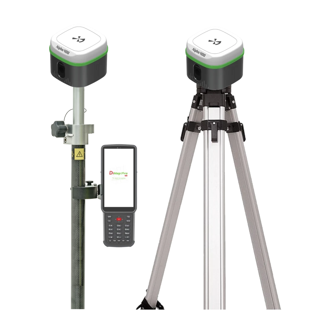
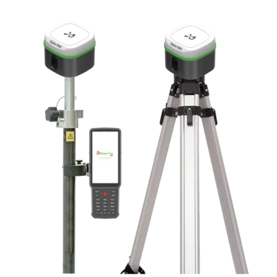
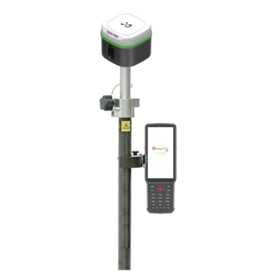
The Alpha 400 Rover Base Set is a complete visual RTK GNSS system for surveyors, construction teams, engineers, GIS users and drone mapping professionals who need their own base and rover setup. The set combines two Alpha 400 GNSS receivers with the Alpha B55 data collector and DiMap Pro field software, making it suitable for accurate point measurement, stakeout, CAD mapping, control work and site layout without relying only on a nearby RTK network.
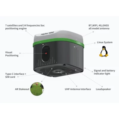
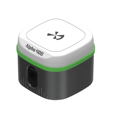
With 1408 GNSS channels, 60° IMU tilt compensation, AR visual stakeout, 4G connectivity and an integrated 2W UHF radio, the Alpha 400 Rover Base Set is built for practical fieldwork on construction sites, road projects, utility routes, solar farms and remote survey locations. The base can transmit corrections to the rover over UHF radio, while the rover supports visual positioning and tilt-compensated measurement for faster work around obstacles and hard-to-reach points.
Alpha 400 Rover Base Set Highlights
| System Type | Complete GNSS rover and base set |
|---|---|
| Included Equipment | 2x Alpha 400 receivers, B55 data collector and DiMap Pro software |
| GNSS Channels | 1408 channels with GPS, GLONASS, Galileo, BeiDou, QZSS, SBAS and NavIC |
| IMU Tilt Compensation | Up to 60° tilt with 2 cm compensation accuracy |
| AR Visual Stakeout | Visual point finding with 1 cm stakeout accuracy |
| Internal UHF Radio | 2W transceiver, 410–470 MHz, base and rover workflow |
| Connectivity | 4G, Wi-Fi, Bluetooth 5.0, Type-C and SIM support |
| Field Durability | IP67 receiver and controller protection |

Valued customers:


Find RTK Networks
Search NTRIP providers and connect to reliable RTK correction services.
Description
Alpha 400 Rover Base Set for Complete RTK Surveying
The Alpha 400 Rover Base Set is a complete GNSS RTK system for professionals who want to work with their own base and rover configuration. It is designed for land surveyors, construction layout teams, civil engineers, GIS field crews, utility mapping teams and drone pilots who need accurate positioning in areas where a fixed RTK network is not available, not preferred or not reliable enough for the job.
The set includes two Alpha 400 GNSS receivers, the Alpha B55 data collector and DiMap Pro field software. One receiver can be used as the base station while the other works as the rover. This gives field crews a self-contained RTK setup for control surveys, topographic work, stakeout, road projects, infrastructure layouts, solar farm construction, utility corridors and general mapping tasks.
Why Choose a Rover and Base Set?
A rover-only setup is often enough when a stable NTRIP or CORS correction service is available. A rover and base set gives the user more independence. The base receiver is positioned over a known point or project control point and sends RTK corrections to the rover. This is especially useful on remote sites, large construction areas, agricultural projects, drone mapping jobs and locations with limited mobile internet coverage.
For surveyors and site teams, this means the work is less dependent on third-party correction networks. It also gives more control over the local project reference, which is useful when working from site control, checking machine guidance points or maintaining consistency across repeated visits to the same project.
Visual RTK for Easier Field Measurement
The Alpha 400 combines GNSS, IMU and optical positioning technology. In practical fieldwork, this helps users measure points more easily when the survey point is not simple to access. Around walls, fences, traffic, parked machinery, ditches or building corners, the visual workflow can reduce unnecessary pole repositioning and make point collection more intuitive.
The receiver supports photoelectric measurement through a professional camera and image processing engine. The operator can work with visual information on screen and obtain coordinate data in real time. This is useful for detail surveys, utility mapping, construction checks, site documentation and measurements where a standard GNSS-only workflow would be slower.
AR Visual Stakeout for Construction and Survey Layout
AR visual stakeout helps the user find points in the real world using visual guidance. Instead of only following a direction arrow and distance value, the operator can see the stakeout location in the field view. This makes the process easier for construction workers, junior surveyors and field crews who need to find design points quickly on busy sites.
The Alpha 400 is specified with 1 cm AR visual stakeout accuracy. For road work, solar layouts, electric line projects, building set-out, earthworks and infrastructure stakeout, this helps reduce searching time and makes the point-finding process easier to understand.
60 Degree IMU Tilt Compensation
The built-in IMU tilt function supports measurements at up to 60° pole tilt. This is useful when the operator cannot hold the pole perfectly vertical or cannot stand directly above the point. In daily work, this can help when measuring beside walls, under edges, near fences, close to traffic or around obstacles on a construction site.
The Alpha 400 is designed as a calibration-free tilt system. After moving a few steps, the receiver can enter inertial navigation mode. This keeps the workflow smooth and avoids repeated setup steps during point collection or stakeout.
Strong Multi-Constellation GNSS Performance
The Alpha 400 uses a 1408-channel GNSS engine and supports GPS, GLONASS, Galileo, BeiDou, QZSS, SBAS and NavIC signals. This wide satellite support helps the receiver maintain stable tracking in different regions and field conditions.
For RTK work, the receiver is specified with horizontal accuracy of ±8 mm + 1 ppm and vertical accuracy of ±15 mm + 1 ppm. In real projects, this level of performance is suitable for survey-grade tasks such as control checks, topographic surveys, construction layout, road staking, utility surveys and drone ground control point measurement.
Base Rover Communication with UHF and 4G
The Alpha 400 receiver includes a 2W internal UHF transceiver operating from 410 to 470 MHz. This allows the base receiver to send RTK correction data to the rover without needing a mobile correction network. The system also supports common radio communication protocols including TRIMTALK, TRIMMARK, SOUTH and SATEL formats, which can be useful for mixed equipment fleets or different site setups.
The receiver also includes 4G, Wi-Fi, Bluetooth 5.0, Type-C and SIM support. This gives users flexibility for NTRIP work, controller connection, data transfer and base-rover communication depending on the project location and preferred workflow.
B55 Data Collector and DiMap Pro Field Software
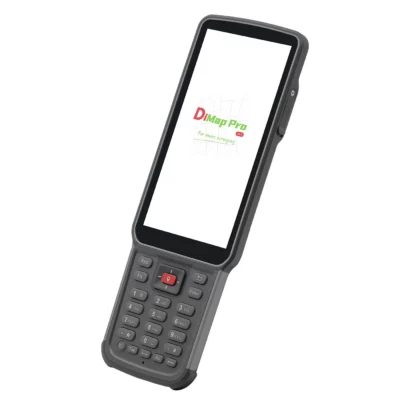
The Alpha 400 Rover Base Set includes the Alpha B55 data collector. The B55 is an Android 11 field controller with an 8-core 2.0 GHz processor, 5.5 inch display, 4 GB RAM, 64 GB storage, Bluetooth 5.0, dual SIM support, Wi-Fi and a 7700 mAh battery. It is also IP67 rated, making it suitable for outdoor survey and construction use.
DiMap Pro field software supports common survey and layout tasks including point survey, detail survey, control point survey, point stakeout, CAD mapping, road stakeout, electric line survey, DSM stakeout, polyline survey, polygon survey, spiral stakeout, electric tower stakeout and photovoltaic stakeout.
For users working with design drawings, DiMap Pro includes CAD tools, background layer setup, offset point correction, tilt measurement accuracy inspection, post-measurement correction, function customization and a built-in calculator. This makes the set practical for both professional surveyors and construction teams who need to move between measuring, checking and staking out points during the same working day.
Built for Long Field Days
Each Alpha 400 receiver has a compact 100 mm x 100 mm x 80 mm body and weighs 650 g. The lightweight design is comfortable for long days on a pole, while the IP67 rating helps protect the receiver against dust and water in demanding outdoor conditions.
The receiver is specified for up to 18 hours in CORS or NTRIP mode, 15 hours in radio receiving mode and 8 hours in radio transmitting mode. This is important for a rover and base workflow because the base station often needs to remain active while the rover moves around the project area.
Typical Users and Applications
The Alpha 400 Rover Base Set is suitable for land surveyors who need a complete independent RTK kit, construction teams carrying out layout work, GIS users collecting accurate asset positions, drone pilots setting ground control or using a GNSS base station, and engineering teams working on roads, utilities, photovoltaic sites, earthworks and infrastructure projects.
It is a practical choice for buyers who want more than a single rover. With two receivers, a field controller and survey software included, the Alpha 400 Rover Base Set gives teams the tools needed to start a complete base-rover workflow and keep accurate positioning under their own control.
Buying the Alpha 400 Rover Base Set from Global GPS Systems
Global GPS Systems supplies the Alpha 400 Rover Base Set with worldwide delivery and product support for professional GNSS users. Buyers can use Global GPS Systems to compare RTK receivers, check which configuration best fits their workflow and choose a setup for surveying, construction, GIS, drone mapping or infrastructure projects.
Datasheets & Manuals
Datasheets and manuals
Datasheets
Specifications
Alpha 400 Rover & Base Set Specifications
Product Overview
| Product Name | Alpha 400 Rover & Base Set |
|---|---|
| Product Type | Professional GNSS RTK rover and base surveying system |
| Receiver Model | Alpha 400 Visual Positioning RTK |
| Data Collector Model | Alpha B55 PDA Collector |
| Manufacturer | Alpha Surveying Technology Co., Ltd. |
| System Configuration | Rover and base RTK configuration with two Alpha 400 receivers, B55 Data Collector and DiMap Pro software |
| Primary Applications | Land surveying, construction layout, geospatial mapping, control point survey, point stakeout, CAD mapping, road stakeout, electric line survey, DSM stakeout, polyline survey, polygon survey, spiral stakeout, electric tower stakeout, photovoltaic stakeout, UAV base station use, unmanned vehicle positioning fusion and SLAM integration |
| Positioning Technologies | GNSS, RTK, IMU, magnetometer, visual positioning and AR visual stakeout |
| Main System Functions | RTK rover/base positioning, tilt compensation, visual positioning, AR stakeout, photoelectric measuring, internal UHF radio communication, 4G connectivity, Bluetooth, Wi-Fi and field data collection |
GNSS Receiver Performance
| GNSS Channels | 1408 channels |
|---|---|
| Positioning Engine | 7-satellite, 24-frequency SoC positioning engine |
| GPS Signals | L1C/A, L1C, L2C, L2P, L5 |
| BeiDou / BDS Signals | B1I, B2I, B3I, B1C, B2a, B2b |
| GLONASS Signals | G1, G2, G3 |
| Galileo Signals | E1, E5a, E5b, E6 |
| QZSS Signals | L1C/A, L1C, L2C, L5 |
| SBAS Signal | L1 |
| NavIC Signal | L5 |
| Receiver Performance Features | Anti-block capability, instant fix, high-precision positioning and calibration-free operation |
Positioning Accuracy
| Positioning Mode | Horizontal Accuracy | Vertical Accuracy |
|---|---|---|
| Static Accuracy | ±(2.5 + 0.5 × 10⁻⁶D) mm | ±(5 + 0.5 × 10⁻⁶D) mm |
| RTK Accuracy | ±(8 + 1 × 10⁻⁶D) mm | ±(15 + 1 × 10⁻⁶D) mm |
Tilt Compensation
| Tilt Technology | Integrated GNSS, IMU and magnetometer data with temperature compensation algorithms |
|---|---|
| Tilt Compensation Accuracy | ±(8 + 0.3 × TILT) mm |
| Compensation Angle | 0° to 60° |
| High-Tilt Accuracy | 2 cm stated accuracy at up to 60° tilt angle |
| Tilt Initialization | No initialization required; inertial navigation mode starts after walking a few steps |
| Tilt Update Rate | 200 Hz |
| Calibration | Calibration-free operation |
Visual Positioning and AR Stakeout
| Visual Positioning | Photoelectric measuring integrated with satellite, IMU and visual technologies |
|---|---|
| Visual Measurement Accuracy | 2 cm |
| Visual Measurement Method | Real-time coordinate data can be obtained by selecting points on the screen |
| Camera System | Professional camera and optical lens with professional image processing engine |
| Backlight Measuring | Supported |
| AR Visual Stakeout | Supported |
| AR Stakeout Accuracy | 1 cm |
| AR Display | 360° real-time clear display under strong light |
| Camera Pixel Rating | 2 MP |
| Field Angle | 75° |
| Optical Performance | Professional lens and algorithms with low optical distortion |
Receiver System Parameters
| Receiver Operating System | Linux |
|---|---|
| Receiver Memory | 32 GB |
| Data Record Formats | DAT, RINEX |
| GNSS Antenna | Integrated GNSS antenna |
| Loudspeaker | Supported; intelligent voice/audio notifications |
| Signal Indicators | Satellite, datalink, Bluetooth and battery indicator lights |
| Interface Customization | Supported for UAV, unmanned vehicle and SLAM integration use cases |
Receiver Communication and Connectivity
| Network | 4G |
|---|---|
| Wi-Fi | 802.11a/b/g/n/ac |
| Bluetooth | BT 5.0 with backward compatibility |
| SIM Card | Supported |
| Type-C Port | Charging, data transmission and external port connection |
| UHF Antenna Interface | SMA radio UHF antenna interface |
| Communication Interfaces | Bluetooth, Wi-Fi, 4G, Type-C and UHF antenna interface |
Receiver UHF Radio
| Internal Radio | Internal UHF transceiver radio |
|---|---|
| Radio Power | 2 W |
| Radio Frequency | 410–470 MHz |
| Operation Mode | Transceiver |
| Supported Radio Protocols | TRIMTALK 450S, TRIMMARK III, SOUTH9600, SOUTH19200, SATEL9600, SATEL19200, Transparent |
| External Radio Support | Supported |
| Stated Radio Range | Up to 5 km, depending on environment and configuration |
Receiver Power and Runtime
| Input Voltage | 9–20 V power delivery |
|---|---|
| CORS / NTRIP Working Time | 18 hours |
| Radio Receiving Working Time | 15 hours |
| Radio Transmitting Working Time | 8 hours |
| Charging Interface | Type-C |
Receiver Physical Specifications
| Receiver Dimensions | 100 mm × 100 mm × 80 mm, excluding 5/8-inch pin interface |
|---|---|
| Receiver Weight | 650 g |
| Mount Interface | 5/8-inch interface referenced in dimension note |
| Receiver Body Type | Lightweight compact RTK receiver body |
Receiver Environmental Specifications
| Operating Temperature | -30°C to +70°C |
|---|---|
| Storage Temperature | -40°C to +80°C |
| Water and Dust Protection | IP67 |
| Shock Resistance | 1.6 m drop resistance on hard ground at normal temperature |
| Humidity | Up to 100% |
B55 Data Collector Performance
| Data Collector Model | Alpha B55 PDA Collector |
|---|---|
| Processor | 8-core 2.0 GHz |
| Operating System | Android 11 |
| Memory / Storage | 4 GB + 64 GB |
| Display | 5.5-inch display |
| Display Resolution | 720 × 1440 |
| Rear Camera | 13 MP autofocus camera |
| Speaker | 95 dB ±3 |
| Microphone | 1 microphone |
| Battery | 3.7 V, 7700 mAh |
B55 Data Collector Connectivity
| Bluetooth | BT 5.0 with BLE |
|---|---|
| Wi-Fi / WLAN | IEEE 802.11 a/b/g/n/ac, 2.4 GHz / 5 GHz |
| WWAN – WCDMA | B1/B2/B5/B8 |
| WWAN – FDD-LTE | B1/B3/B5/B7/B8 |
| WWAN – TDD-LTE | B38/B39/B40/B41 |
| WWAN – GSM | B2/B3/B5/B8 |
| WWAN – CDMA/EVDO | BC0/BC1 |
| NFC Protocol Support | ISO14443A/B, ISO15693 |
| NFC Distance | 0–5 cm |
| Type-C Interface | Supports OTG and fast charging |
| SIM Card Slot | Dual SIM |
| SD Card Slot | Supports up to 256 GB |
B55 Data Collector Physical and Environmental Specifications
| Data Collector Dimensions | 221 mm × 77.7 mm × 16 mm |
|---|---|
| Data Collector Weight | 335 g |
| Operating Temperature | -20°C to +55°C |
| Storage Temperature | -30°C to +70°C |
| Operating Humidity | 5% to 95% |
| Drop Resistance | 1.5 m drop resistance on hard ground |
| IP Protection | IP67 |
Software and Surveying Functions
| Included Field Software | DiMap Pro |
|---|---|
| CAD Engine | Supports CAD files over 100 MB, loading more layers, complete drawing functions and multiple text encoding formats |
| Map and Code Management | Supports Amap and other map/code management functions |
| Additional Software Functions | Offset point correction, background layer setting, tilt measurement accuracy inspection, function customization, post-test correction and built-in calculator |
| Point Survey | Supported |
| Detail Survey | Supported |
| Control Point Survey | Supported |
| Point Stakeout | Supported |
| CAD Mapping | Supported |
| Road Stakeout | Supported |
| Electric Line Survey | Supported |
| DSM Stakeout | Supported |
| Polyline Survey | Supported |
| Polygon Survey | Supported |
| Spiral Stakeout | Supported |
| Electric Tower Stakeout | Supported |
| Photovoltaic Stakeout | Supported |
Package Contents
| Item | Quantity | Notes |
|---|---|---|
| Alpha 400 receiver | 2 | One receiver for rover use and one receiver for base use |
| Alpha B55 Data Collector | 1 | Field controller for surveying and stakeout workflows |
| DiMap Pro software | 1 | Professional field surveying and CAD mapping software |
| Survey pole / centering pole | 1 | For rover operation |
| Bracket | 1 | Controller or receiver mounting accessory |
| Tripod | 1 | For base station setup |
| Radio antenna | Included | For UHF radio operation; quantity may depend on configuration |
| Receiver adapter | Included | Host adapter accessory; quantity may depend on configuration |
| Receiver cable | Included | Host cable accessory; quantity may depend on configuration |
| Controller adapter | Included | Data collector charging/accessory adapter |
| Controller USB cable | Included | Data collector cable |
| Instruction manual | Included | User documentation |
| Carrying case | Included | Transport and storage case |
Specifications and package contents may vary by configuration, region or manufacturer update. Always check the current configuration before ordering.
FAQ
Alpha 400 Rover & Base Set FAQ
Product Overview and Applications
What is the Alpha 400 Rover & Base Set?
The Alpha 400 Rover & Base Set is a complete professional GNSS RTK surveying system with two Alpha 400 receivers, a B55 Data Collector, and DiMap Pro software. It is designed for accurate base-and-rover surveying, mapping, and stakeout work.
Who is the Alpha 400 Rover & Base Set designed for?
This set is designed for land surveyors, construction layout teams, infrastructure contractors, road engineers, utility surveyors, GIS teams, mapping professionals, and other users who need centimetre-level positioning in the field.
What is the difference between the Alpha 400 Rover Set and the Rover & Base Set?
The Rover Set is built around one mobile GNSS rover workflow, while the Rover & Base Set includes both a rover and a base setup. This allows users to create their own local RTK correction setup instead of relying only on external RTK networks.
Why choose a rover and base set instead of a rover-only set?
A rover and base set is useful when working in remote areas, private construction sites, locations with poor internet coverage, or areas without reliable RTK network access. The base can transmit corrections to the rover for independent RTK work.
What types of work can this set be used for?
The Alpha 400 Rover & Base Set can be used for point surveys, detail surveys, control point surveys, CAD mapping, construction layout, road stakeout, infrastructure layouts, electric line surveys, polygon surveys, polyline surveys, photovoltaic stakeout, and other professional GNSS tasks.
Can the Alpha 400 Rover & Base Set be used for construction layout?
Yes. The set is suitable for construction layout and stakeout because it combines RTK positioning, visual positioning, AR visual stakeout, tilt compensation, and a complete base-and-rover correction workflow.
Accuracy, Visual Positioning and AR Stakeout
How accurate is the Alpha 400 Rover & Base Set?
The Alpha 400 supports centimetre-level RTK positioning. The listed RTK accuracy is ±(8 + 1 × 10⁻⁶D) mm horizontally and ±(15 + 1 × 10⁻⁶D) mm vertically, depending on site conditions, satellite visibility, correction setup, and workflow.
What is the visual stakeout accuracy?
The Alpha 400 is specified with 1 cm AR visual stakeout accuracy, helping users find and stake points more clearly in real-world field scenes.
What is visual positioning RTK?
Visual positioning RTK combines GNSS, IMU, magnetometer, optical sensors, and image processing. It allows users to collect coordinates from visible points in the camera view, which is useful for hard-to-reach or obstructed measurement locations.
What is AR visual stakeout?
AR visual stakeout shows stakeout guidance directly in a live camera view. This helps users navigate to target points more intuitively than using only a traditional map, compass, or numeric offset display.
Does the Alpha 400 support tilt compensation?
Yes. The Alpha 400 supports tilt compensation up to 60°, allowing users to measure accurately without keeping the pole perfectly vertical in many field situations.
Does the tilt compensation require calibration?
The Alpha 400 is designed for calibration-free tilt operation. It can enter inertial navigation mode without traditional initialization, helping users start work faster in the field.
Can the Alpha 400 measure hard-to-reach points?
Yes. The visual positioning function can help measure points that are difficult to access directly, such as locations near walls, fences, trenches, traffic, buildings, vegetation, or other obstacles.
GNSS, Base/Rover Communication and Software
Which satellite constellations does the Alpha 400 support?
The Alpha 400 supports GPS, BeiDou, GLONASS, Galileo, QZSS, SBAS, and NavIC signals, giving users broad multi-constellation coverage for professional GNSS fieldwork.
How many GNSS channels does the Alpha 400 have?
The Alpha 400 has 1408 channels, supporting multi-frequency and multi-constellation tracking for stable RTK positioning performance.
Does the Alpha 400 Rover & Base Set include an internal UHF radio?
Yes. The Alpha 400 includes a 2W internal UHF transceiver radio. In a rover and base workflow, the base can transmit correction data and the rover can receive it for RTK positioning.
What UHF frequency range does the Alpha 400 support?
The Alpha 400 supports a 410–470 MHz UHF frequency range and several common radio protocols, including TRIMTALK 450S, TRIMMARK III, SOUTH9600, SOUTH19200, SATEL9600, SATEL19200, and transparent protocol.
Does the Alpha 400 support 4G, NTRIP, and CORS corrections?
Yes. The Alpha 400 supports 4G connectivity and can be used with NTRIP or CORS correction services where suitable network corrections are available.
Does the Alpha 400 have Wi-Fi and Bluetooth?
Yes. The Alpha 400 supports Wi-Fi and Bluetooth 5.0 with backward compatibility, allowing wireless connection to compatible controllers and field workflows.
What software is included with the Alpha 400 Rover & Base Set?
The set includes DiMap Pro software with the B55 Data Collector. DiMap Pro supports field workflows such as point survey, detail survey, control point survey, point stakeout, CAD mapping, road stakeout, polyline survey, polygon survey, spiral stakeout, electric tower stakeout, and photovoltaic stakeout.
Battery, Durability and Included Equipment
How long does the Alpha 400 battery last?
The Alpha 400 offers up to 18 hours of working time in CORS mode, up to 15 hours in radio receiving mode, and up to 8 hours in radio transmitting mode.
Is the Alpha 400 suitable for full-day fieldwork?
Yes. Its long working time, lightweight receiver body, UHF radio, 4G connectivity, and rugged design make it suitable for demanding daily survey and construction workflows.
How much does each Alpha 400 receiver weigh?
Each Alpha 400 receiver weighs approximately 650 g, making it a compact and lightweight option for professional RTK surveying.
Is the Alpha 400 waterproof and dustproof?
Yes. The Alpha 400 has an IP67 protection rating, making it resistant to dust and water for use in challenging outdoor field conditions.
What operating temperature range does the Alpha 400 support?
The Alpha 400 is specified for operation from -30°C to +70°C and storage from -40°C to +80°C.
What is included in the Alpha 400 Rover & Base Set?
The Alpha 400 Rover & Base Set includes the equipment needed for a complete rover and base workflow, including Alpha 400 receivers, the B55 Data Collector, DiMap Pro software, radio antennas, poles, brackets, cables, chargers, documentation, and carrying case components.
Reviews (0)
Only logged in customers who have purchased this product may leave a review.


Reviews
There are no reviews yet