


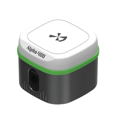
Alpha 400 Rover Set Visual RTK GNSS with AR Stakeout
This product is Available
Contact our experts for the best possible price and configuration.
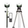
The Alpha 400 Rover Set is a complete visual RTK GNSS solution for surveyors, construction teams, GIS users and drone mapping professionals who need accurate, practical positioning in the field. The set combines the compact Alpha 400 GNSS receiver with the Alpha B55 data collector and field software for measuring points, staking out designs, CAD mapping and daily RTK survey work.
With 1408 channels, multi-constellation tracking, 60° IMU tilt compensation and AR visual stakeout, the Alpha 400 helps crews measure faster in open sites, around obstacles and during layout tasks where seeing the point on screen makes the job easier. Integrated 4G, WiFi, Bluetooth and UHF communication give flexible options for NTRIP network corrections or radio-based rover workflows.
Alpha 400 Rover Set Highlights
| GNSS Channels | 1408 channels with GPS, GLONASS, Galileo, BeiDou, QZSS, SBAS and NavIC support |
|---|---|
| IMU Tilt Compensation | Up to 60° tilt for faster measurements without perfectly levelling the pole |
| AR Visual Stakeout | Camera based visual stakeout with real scene guidance and 1 cm point finding accuracy |
| Communication | 4G, WiFi, Bluetooth 5.0 and 2 W internal UHF radio 410 to 470 MHz |
| Field Controller | Alpha B55 Android 11 data collector with 5.5 inch display and 7700 mAh battery |
Valued customers:


Find RTK Networks
Search NTRIP providers and connect to reliable RTK correction services.
Description
Complete visual RTK rover set for professional fieldwork
The Alpha 400 Rover Set is built for field teams that need a compact, accurate and modern RTK GNSS system for everyday surveying and layout work. It is suitable for construction setout, topographic surveys, boundary work, GIS data collection, road and utility projects, drone ground control points and general engineering measurements.
The set includes the Alpha 400 visual positioning RTK receiver, Alpha B55 data collector, field software, pole, bracket and required accessories, giving crews a ready to use rover setup for RTK network or radio correction workflows. For buyers comparing GNSS rover sets, the main advantage of this system is the combination of IMU tilt, visual measurement and AR stakeout in a lightweight receiver.
Visual positioning and AR stakeout
The Alpha 400 uses GNSS, IMU and visual technology together to make field measurements easier and more intuitive. Instead of relying only on numbers and arrows, AR visual stakeout shows the target in the real scene on the controller screen. This is especially useful for construction layout, point recovery and busy sites where the operator needs to move quickly from point to point.
The receiver has a professional camera system and image processing engine, allowing users to work with visual guidance and obtain coordinate data directly from the screen. In practical terms, this helps reduce confusion during stakeout, makes it easier for less experienced operators to follow the design, and improves workflow when working around structures, vehicles, stockpiles or other site obstacles.
60° IMU tilt for faster measuring
The Alpha 400 supports IMU tilt compensation up to 60°. This allows the operator to measure points without holding the pole perfectly vertical, which is useful near walls, fences, kerbs, trees, trenches and building corners. For construction workers and surveyors, tilt compensation can save time because fewer measurements need to be repeated due to awkward pole positions.
The system is designed to enter inertial navigation mode without a complicated calibration routine. For daily fieldwork, that means faster setup and fewer interruptions when moving between survey points.
Multi constellation GNSS performance
With 1408 channels and support for GPS, GLONASS, Galileo, BeiDou, QZSS, SBAS and NavIC signals, the Alpha 400 is designed to track a wide range of satellites. More satellite availability can help maintain stable RTK performance in typical field environments, especially where sky visibility changes during the day.
The receiver supports RTK accuracy suitable for professional survey and construction work. For users measuring control points, site details, road features or ground control points for drone mapping, this gives a practical balance between accuracy, portability and field speed.
Flexible communication for RTK corrections
The Alpha 400 Rover Set supports several correction and communication options, including 4G, WiFi, Bluetooth 5.0 and an internal 2 W UHF radio. This gives users flexibility to work with NTRIP correction services, base and rover radio setups, or controller based field workflows depending on the project location.
The integrated UHF radio operates in the 410 to 470 MHz range and supports common radio protocols. This is useful for teams that work away from mobile data coverage or already use radio correction setups on construction, infrastructure and land surveying projects.
Designed for long field days
The Alpha 400 receiver is compact and lightweight, with a body size of approximately 100 mm by 100 mm by 80 mm and a weight of about 650 g. The receiver is rated IP67 for dust and water protection and is designed to handle normal field conditions, including rain, dust, site handling and changing temperatures.
Battery performance supports long survey sessions, with up to 18 hours in NTRIP mode, 15 hours in radio receiving mode and 8 hours in radio transmitting mode. For field crews, this reduces downtime and helps keep work moving through a full day of measuring, checking and staking out.
Alpha B55 data collector included
The included Alpha B55 data collector gives the rover set a dedicated field controller for data collection and stakeout. It runs Android 11 and uses an 8 core 2.0 GHz processor with 4 GB RAM and 64 GB internal storage. The 5.5 inch display is practical for GNSS field software, CAD viewing, point lists and mapping tasks.
The B55 includes 4G mobile network support, WiFi, Bluetooth 5.0, NFC, a 13 MP autofocus rear camera, dual SIM support and a 7700 mAh battery. Its IP67 protection and 1.5 m drop resistance make it suitable for outdoor survey work, construction sites and GIS projects where consumer phones or tablets may not be rugged enough.
Field software for survey and mapping tasks
The Alpha 400 Rover Set is supplied with field software for common survey workflows such as point survey, detail survey, control point survey, point stakeout, CAD mapping, road stakeout and utility related measurements. The software is also designed to handle larger CAD files and multiple layers, which is helpful when working with site drawings, design files and background maps.
For surveyors and engineers, this means the rover set can be used beyond basic point collection. It supports practical field tasks such as checking design positions, collecting as built data, setting out construction points and managing measurement data directly on the controller.
Who is the Alpha 400 Rover Set for?
The Alpha 400 Rover Set is a strong option for professionals who need RTK accuracy with modern visual guidance. It is well suited to land surveyors, construction layout crews, civil engineering contractors, drone mapping teams, GIS data collectors, utility companies and site managers who need reliable positioning equipment without building a system from separate components.
Surveyors will value the GNSS performance, tilt compensation and CAD workflow. Construction teams will benefit from AR stakeout and fast point finding. Drone pilots can use the receiver for ground control points or as a base station for UAV related workflows. GIS users can collect accurate asset positions with a rugged controller and professional RTK receiver.
Buying from Global GPS Systems
Global GPS Systems supplies the Alpha 400 Rover Set with product knowledge, international shipping experience and support for professional GNSS users. This is useful for buyers who want help comparing RTK rover sets, choosing correction services, understanding radio or NTRIP workflows, and selecting accessories for real field conditions.
The Alpha 400 Rover Set is a practical visual RTK GNSS package for teams that want accurate positioning, faster stakeout, rugged hardware and a complete rover workflow in one system.
Datasheets & Manuals
Datasheets and manuals
Datasheets
Specifications
Alpha 400 Rover Set Specifications
Product Overview
| Product Name | Alpha 400 Rover Set |
|---|---|
| Product Type | Visual positioning RTK GNSS rover set |
| Main Receiver | Alpha 400 Visual Positioning RTK GNSS Receiver |
| Data Collector | Alpha B55 PDA / data collector |
| Included Field Software | DiMap Pro surveying software for Android |
| Typical Users | Surveyors, construction teams, engineers, GIS users, mapping professionals, drone and infrastructure teams |
| Typical Applications | RTK point collection, detail survey, control point survey, CAD mapping, CAD stakeout, construction layout, road stakeout, line stakeout, DSM stakeout, electric line survey, electric tower stakeout, photovoltaic stakeout and GNSS field workflows |
GNSS Receiver
| GNSS Channels | 1408 channels |
|---|---|
| Positioning Engine | 7-satellite, 24-frequency SoC positioning engine |
| Visual Positioning | Supported |
| AR Visual Stakeout | Supported |
| IMU Tilt Measurement | Supported |
| Calibration-Free Tilt Operation | Supported; no initialization required according to manufacturer documentation |
| Integrated Sensors | GNSS, IMU and magnetometer with temperature compensation algorithms |
| Operating System | Linux |
| Internal Memory | 32 GB |
| Data Recording Formats | DAT, RINEX |
GNSS Signal Tracking
| GPS | L1C/A, L1C, L2C, L2P, L5 |
|---|---|
| BDS / BeiDou | B1I, B2I, B3I, B1C, B2a, B2b |
| GLONASS | G1, G2, G3 |
| Galileo | E1, E5a, E5b, E6 |
| QZSS | L1C/A, L1C, L2C, L5 |
| SBAS | L1 |
| NavIC | L5 |
Positioning Accuracy
| Mode / Function | Horizontal Accuracy | Vertical / Other Accuracy |
|---|---|---|
| Static Accuracy | ±(2.5 + 0.5 × 10⁻⁶D) mm | ±(5 + 0.5 × 10⁻⁶D) mm |
| RTK Accuracy | ±(8 + 1 × 10⁻⁶D) mm | ±(15 + 1 × 10⁻⁶D) mm |
| Visual Positioning Measurement | 2 cm | Real-time coordinate acquisition by selecting points on screen |
| AR Visual Stakeout | 1 cm | Point-finding accuracy in real scenes |
Tilt Compensation
| Tilt Compensation Range | 0°–60° |
|---|---|
| Tilt Compensation Accuracy | ±(8 + 0.3TILT) mm |
| Tilt Update Rate | 200 Hz |
| Calibration | Calibration-free operation stated |
| Initialization | No initialization required; enter inertial navigation mode by walking a few steps |
Visual Positioning and AR Stakeout
| Visual Positioning | Integrated satellite, IMU and visual positioning technologies |
|---|---|
| Visual Measurement Accuracy | 2 cm |
| AR Stakeout Accuracy | 1 cm |
| AR Display Support | 360° real-time clear display under strong light |
| Camera Resolution | 2 MP |
| Camera Field Angle | 75° |
| Image Processing | Professional image processing engine for coordinate capture by screen point selection |
| Backlight Measurement | Supported according to manufacturer brochure |
Receiver Connectivity
| Mobile Network | 4G |
|---|---|
| WiFi | 802.11a/b/g/n/ac |
| Bluetooth | Bluetooth 5.0 with backward compatibility |
| SIM Card | Supported |
| Type-C Port | Charging, data transmission and external port connection |
| UHF Antenna Interface | SMA radio UHF antenna interface |
| External Radio | Supported |
| NTRIP / CORS Workflow | Supported via 4G network connection where compatible correction services are available |
Internal UHF Radio
| Radio Type | Internal UHF transceiver |
|---|---|
| Radio Power | 2 W |
| Frequency Range | 410–470 MHz |
| Operation Mode | Transceiver |
| Communication Protocols | TRIMTALK 450S, TRIMMARK III, SOUTH9600, SOUTH19200, SATEL9600, SATEL19200, Transparent |
| External Radio Support | Yes |
Receiver Power and Runtime
| Power Delivery Voltage | 9–20 V |
|---|---|
| Working Time in NTRIP / CORS Mode | Up to 18 hours |
| Working Time in Radio Receiving Mode | Up to 15 hours |
| Working Time in Radio Transmitting Mode | Up to 8 hours |
Receiver Ports, Indicators and Audio
| SMA Port | Radio UHF antenna |
|---|---|
| Type-C Port | Charging, data transmitting and external port connection |
| Indicator Lights | Satellite, datalink, Bluetooth and battery indicators |
| Loudspeaker | Supports intelligent voice prompts |
Receiver Physical Specifications
| Dimensions | 100 mm × 100 mm × 80 mm, excluding 5/8-inch pin interface |
|---|---|
| Weight | 650 g |
| Mount Interface | 5/8-inch pin interface |
| Design Type | Compact lightweight visual RTK receiver |
Receiver Environmental Specifications
| Operating Temperature | -30°C to +70°C |
|---|---|
| Storage Temperature | -40°C to +80°C |
| Water / Dust Protection | IP67 |
| Shock Resistance | 1.6 m drop resistance on hard ground at normal temperature |
| Humidity | Up to 100% |
Alpha B55 Data Collector
| Device Type | Professional PDA data collector for GNSS surveying |
|---|---|
| Processor | 8-core 2.0 GHz |
| Operating System | Android 11 |
| Display | 5.5-inch screen |
| Display Resolution | 720 × 1440 |
| Internal Storage | 4 GB + 64 GB |
| Rear Camera | 13 MP autofocus camera |
| Battery | 3.7 V, 7700 mAh |
| Speaker | 95 dB ±3 |
| Microphone | MIC × 1 |
| Type-C | Supports OTG and fast charging |
| Bluetooth | Bluetooth 5.0 BLE |
| WiFi / WLAN | IEEE 802.11 a/b/g/n/ac, 2.4 GHz / 5 GHz |
| NFC | ISO14443A/B and ISO15693; 0–5 cm distance |
| SD Card Slot | Supports up to 256 GB |
| SIM Card Slot | Dual SIM |
| Dimensions | 221 mm × 77.7 mm × 16 mm |
| Weight | 335 g |
Alpha B55 Mobile Network Bands
| WCDMA | B1, B2, B5, B8 |
|---|---|
| FDD-LTE | B1, B3, B5, B7, B8 |
| TDD-LTE | B38, B39, B40, B41 |
| GSM | B2, B3, B5, B8 |
| CDMA / EVDO | BC0, BC1 |
Alpha B55 Environmental Specifications
| Operating Temperature | -20°C to +55°C |
|---|---|
| Storage Temperature | -30°C to +70°C |
| Operating Humidity | 5%–95% |
| Drop Resistance | 1.5 m onto hard ground |
| IP Protection | IP67 |
DiMap Pro Software
| Software Name | DiMap Pro |
|---|---|
| Platform | Android |
| Manual Version Referenced | DiMap Pro 4.3, version date 2023.04 |
| Core Modules | Project, Device, Survey and Tools |
| Project Functions | Project manager, localization, calibrate point, coordinate system, points database, code library manager, import data, export data, offset point correction, grid to ground, survey range settings, layers settings, software settings and software information |
| Device Functions | Communication, rover, base, static, device information, device settings, static and collect points |
| Survey Functions | Point survey, detail survey, control point survey, point stakeout, CAD mapping, CAD stakeout, polyline survey, polygon survey, line stakeout, DSM stakeout, electric lines survey, electric towers stakeout and function customization |
| Tools | Coordinates converter, angle converter, perimeter and area, volume calculation, file sharing, calculator, average calculation, coordinate positive calculation, coordinate inverse calculation, point line calculation, circle center calculation, offset tools, vector, two lines angle, intersection calculation, resection, forward intersection, offset point calculation, extend point calculation and equal point calculation |
| CAD File Handling | Supports opening and running CAD files over 100 MB, loading more layers, drawing functions and multiple text encoding formats |
| Map and Code Management | Supports Amap and other map and code management functions |
| Additional Field Functions | Offset point correction, background layer settings, tilt measurement accuracy inspection, function customization, post-test correction and built-in calculator |
Correction and Field Workflow Support
| Rover Workflow | Supported |
|---|---|
| Base Workflow | Supported in DiMap Pro device functions; this set is supplied as a rover package |
| Static Workflow | Supported in DiMap Pro device functions |
| NTRIP / CORS Corrections | Supported via 4G network connection where compatible correction services are available |
| UHF Radio Corrections | Supported through internal 2 W UHF transceiver |
| External Radio Corrections | Supported |
| Data Collection | Point collection, detail survey, control point survey, polyline survey and polygon survey |
| Stakeout Workflows | Point stakeout, AR visual stakeout, CAD stakeout, line stakeout, road stakeout, DSM stakeout, electric tower stakeout and photovoltaic stakeout |
Package Contents
| Item | Quantity | Notes |
|---|---|---|
| Alpha 400 Receiver | 1 | Visual positioning RTK GNSS receiver |
| Radio Antenna | 1 | For UHF radio communication |
| Host Adapter | 1 | Receiver accessory |
| Host Cable | 1 | Receiver cable |
| Controller | 1 | Alpha B55 data collector |
| Controller Adapter | 1 | Controller accessory |
| Controller Cable | 1 | Controller cable |
| Centering Pole | 1 | Field pole for rover operation |
| Bracket | 1 | Controller / field mounting bracket |
| Instruction | 1 | Documentation / instruction material |
| Carrying Case | 1 | Transport and storage case |
Specifications and package contents may vary by configuration, region or manufacturer update. Always check the current configuration before ordering.
FAQ
Alpha 400 Rover Set FAQ
Product Overview
What is the Alpha 400 Rover Set?
The Alpha 400 Rover Set is a complete visual positioning RTK GNSS rover package for professional field measurement, surveying, mapping and stakeout. It includes the Alpha 400 GNSS receiver, B55 data collector, DiMap Pro surveying software, pole, bracket, cables, adapters and carrying case.
Who is the Alpha 400 Rover Set designed for?
It is designed for land surveyors, construction teams, civil engineers, GIS users, utility mapping teams, drone mapping professionals and other geospatial users who need accurate RTK field measurements and practical stakeout tools.
What is included in the Alpha 400 Rover Set?
The professional set includes one Alpha 400 receiver, radio antenna, host adapter, host cable, controller, controller adapter, controller cable, centering pole, bracket, instruction material and carrying case.
Is this a complete RTK rover package?
Yes. The set combines the GNSS receiver, handheld controller, field software and essential field accessories needed for rover-based RTK workflows. RTK corrections can be received through compatible NTRIP/CORS services or a suitable radio-based correction setup.
What is the difference between the Alpha 400 receiver and the Alpha 400 Rover Set?
The Alpha 400 receiver is the GNSS positioning unit itself. The Alpha 400 Rover Set is the complete field package, including the receiver, B55 data collector, DiMap Pro software, pole, bracket and accessories for professional rover use.
Does this set include a base station?
No. This is a rover set. It is intended for users who will receive RTK corrections from an RTK network, CORS/NTRIP service or a compatible base station. Users who need both rover and base equipment should choose a rover-base configuration.
Accuracy, GNSS and Tilt Compensation
What RTK accuracy does the Alpha 400 provide?
The stated RTK accuracy is horizontal ±(8+1×10⁻⁶D) mm and vertical ±(15+1×10⁻⁶D) mm. Actual field performance depends on satellite visibility, correction quality, site conditions, pole setup and workflow.
Which GNSS constellations does the Alpha 400 support?
The Alpha 400 supports GPS, BDS, GLONASS, Galileo, QZSS, SBAS and NavIC signals across 1408 GNSS channels. Multi-constellation tracking helps improve satellite availability and positioning reliability in professional fieldwork.
Does the Alpha 400 support tilt compensation?
Yes. The Alpha 400 supports calibration-free tilt compensation from 0° to 60°. This helps users measure points when the pole cannot be held perfectly vertical, such as near walls, fences, trenches, slopes or other obstacles.
Do I need to calibrate the IMU before measuring?
The Alpha 400 is specified with calibration-free tilt compensation. This allows users to start measuring more quickly without a separate IMU calibration routine in normal field workflows.
Can the Alpha 400 measure points without keeping the pole vertical?
Yes. Its 0°–60° tilt compensation allows tilt-corrected measurements when the pole is angled. This can save time in practical site conditions, although good surveying practice and proper quality checks remain important.
What is the visual positioning measurement accuracy?
The stated visual positioning measurement accuracy is 2 cm. This function combines GNSS, IMU and visual positioning technology to support practical measurement workflows in the field.
Visual Positioning, AR Stakeout and Software
What is visual positioning RTK?
Visual positioning RTK combines satellite positioning, IMU tilt data and camera-based visual technology. It helps users connect the digital project with the real site and can support measurement by selecting points visually on the controller screen.
What is AR visual stakeout?
AR visual stakeout gives the operator an on-screen real-world view that helps guide them to stakeout points. Instead of relying only on arrows, distances and numbers, the user can see visual guidance to the target position.
What is the AR visual stakeout accuracy?
The Alpha 400 has a stated AR visual stakeout accuracy of 1 cm. This makes it useful for construction layout, road work, CAD-based stakeout and other workflows where users need clear point-finding guidance.
What software is included with the Alpha 400 Rover Set?
The set includes DiMap Pro surveying software for Android. It supports project setup, device connection, point collection, stakeout, CAD mapping, road tools, line stakeout and field calculation workflows.
Can DiMap Pro be used with CAD files?
Yes. DiMap Pro supports CAD mapping and CAD stakeout. It can work with large drawing files, multiple layers and field drawing functions, helping users bring design data directly into the field.
Which survey tasks can DiMap Pro support?
DiMap Pro supports point survey, detail survey, control point survey, point stakeout, CAD mapping, CAD stakeout, polyline survey, polygon survey, line stakeout, road tools, DSM stakeout, electric line survey and electric tower stakeout.
Connectivity, Field Use and Applications
Can the Alpha 400 Rover Set work with an RTK network?
Yes. The Alpha 400 includes 4G network support, making it suitable for NTRIP and CORS correction workflows where compatible RTK correction services are available.
Does the Alpha 400 have an internal radio?
Yes. The Alpha 400 includes a 2 W internal UHF transceiver with a 410–470 MHz frequency range. It also supports multiple radio protocols and can support external radio use where needed.
How long can the Alpha 400 work in the field?
The stated working time is up to 18 hours in NTRIP/CORS mode, up to 15 hours in radio receiving mode and up to 8 hours in radio transmitting mode. Actual battery life depends on settings, temperature, radio use and field conditions.
Is the Alpha 400 rugged enough for outdoor work?
Yes. The receiver is specified with IP67 water and dust protection, an operating temperature range of -30°C to +70°C, storage temperature from -40°C to +80°C, humidity resistance up to 100% and normal-temperature drop resistance of 1.6 m on hard ground.
What applications is the Alpha 400 Rover Set suitable for?
The Alpha 400 Rover Set is suitable for RTK point collection, topographic surveys, construction layout, CAD stakeout, road stakeout, line stakeout, electric line survey, tower stakeout, DSM stakeout, polyline and polygon surveys, photovoltaic stakeout and infrastructure measurement.
Should I use an RTK network or a base station with the Alpha 400?
If your work area has reliable RTK network coverage, the Alpha 400 Rover Set can receive corrections through NTRIP/CORS. If there is no reliable mobile data or RTK network coverage, a compatible local base station or rover-base setup may be the better workflow.
Is the Alpha 400 Rover Set suitable for construction stakeout?
Yes. The combination of RTK accuracy, 60° tilt compensation, AR visual stakeout and CAD support makes it well suited for construction layout, road work, site measurements and design-to-field stakeout workflows.
Additional information
| GNSS feature | GNSS with Camera, GNSS with IMU |
|---|
Reviews (0)
Only logged in customers who have purchased this product may leave a review.

Reviews
There are no reviews yet