

 GPS & GNSS
 Lidar scanning
 Total Station
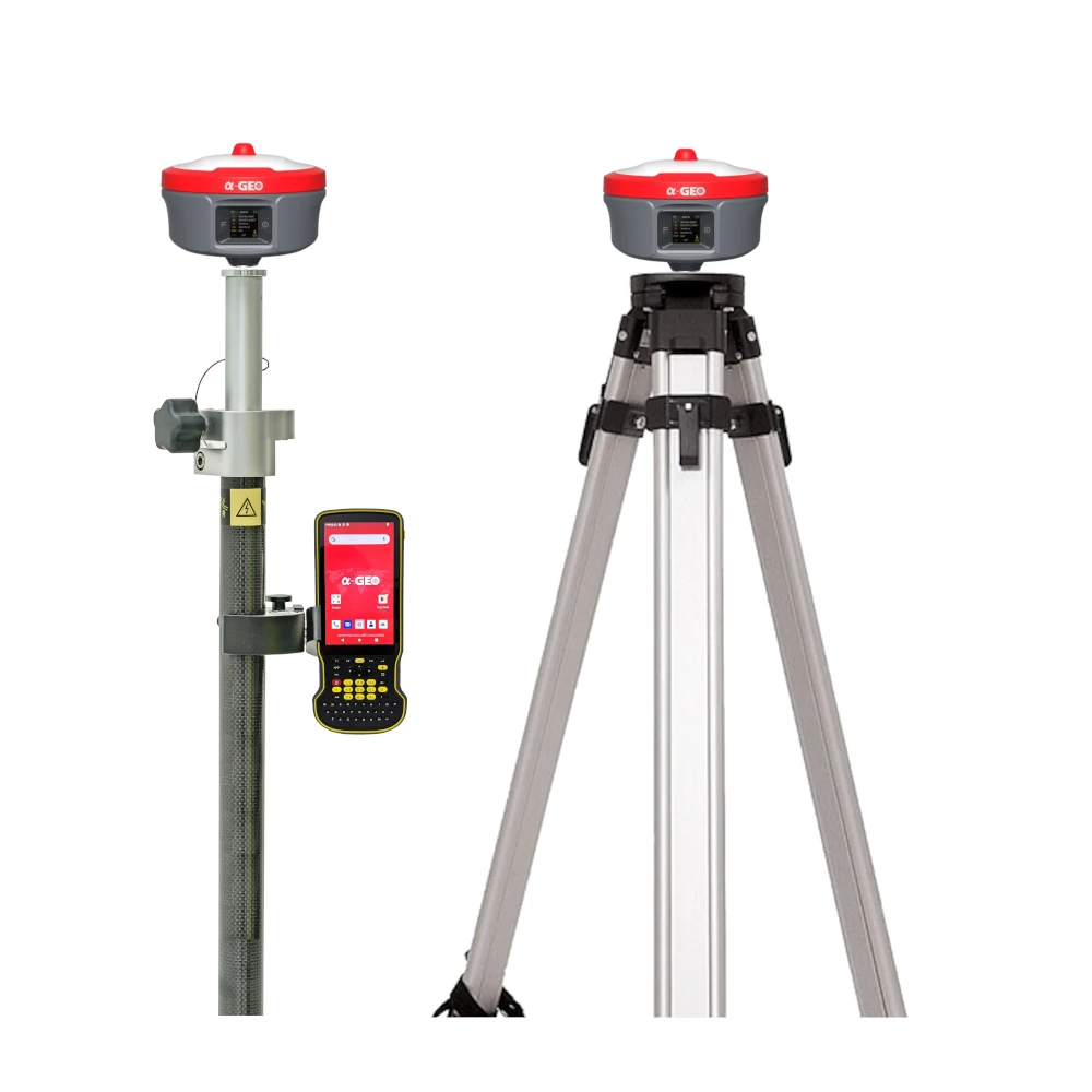


a Geo Matrix Ultra Super Rover Base Set RTK GNSS
Get the best price for your setup
Contact our experts for the best possible price and configuration.
- Fast response
- Expert configuration advice
- No overpaying for features you do not need
The a-Geo Matrix Ultra Super Rover & Base Set is a complete RTK GNSS solution for surveyors, construction teams, engineers, GIS users and drone mapping professionals who need a reliable rover and long-range local base station. The rover supports visual measurement, AR stakeout, IMU tilt and laser measurement, while the Super Base provides strong 5W UHF correction transmission for larger worksites and remote projects.
a-Geo Matrix Ultra Super Rover & Base Set Highlights
| GNSS Channels | 1408 channels |
|---|---|
| Rover Measurement Tools | Visual camera, AR stakeout camera, laser measurement and IMU tilt |
| Super Base UHF Radio | 5W internal UHF transmitter with typical 20 km working distance |
| IMU Tilt | 120° tilt compensation with 400 Hz update rate |
| Satellite Tracking | GPS, GLONASS, Galileo, BeiDou, QZSS, IRNSS, SBAS and L-Band |
| Connectivity | 4G modem, UHF 410–470 MHz, Wi-Fi, Bluetooth 5.2, USB-C and LEMO |
| Protection | IP67 dust and water protection with 2 m pole drop resistance |


Valued customers:










Find RTK Networks
Search NTRIP providers and connect to reliable RTK correction services.
Description
Complete RTK GNSS rover and super base solution
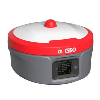
The a-Geo Matrix Ultra Super Rover & Base Set is built for field teams that need a complete RTK setup instead of a single receiver. It combines a feature-rich Matrix Ultra rover with a Matrix Ultra-B Super Base, giving surveyors and construction professionals the flexibility to work with a local base station, UHF corrections and modern rover measurement tools.
This set is well suited for topographic surveys, construction layout, road projects, infrastructure work, earthworks, GIS data collection, drone ground control and large sites where a dependable local correction source is preferred. It is especially useful when mobile internet coverage is limited, when network RTK is not available, or when a team wants more control over its own base and rover workflow.
Matrix Ultra rover for faster point collection
The Matrix Ultra rover is designed for more than standard pole-based GNSS measurement. It includes visual measurement, AR stakeout support, laser measurement and IMU tilt compensation. In practical fieldwork, this helps crews measure points that are difficult to occupy directly, such as corners, walls, fences, trenches, stockpiles, slopes, traffic areas or obstructed locations.
The laser measurement function allows reflectorless measurement for points that are hard or unsafe to reach with the pole. For construction and survey teams, this can reduce walking, speed up data capture and make it easier to collect detail in complex environments. The visual and AR functions also help users understand where they are measuring or staking out, which is useful when working from digital designs or checking points on busy job sites.
Super Base with 5W UHF for long-range correction links
The included Matrix Ultra-B Super Base is focused on stable long-range RTK correction transmission. Its integrated 5W UHF radio is designed for typical working distances of up to 20 km under general conditions. This can remove the need for a separate external radio, external battery, extra antenna and additional cabling on many projects.
The UHF system operates in the 410–470 MHz range and supports common radio protocols including Trimtalk450S, AlphaTalk15, South, Satel and PCC-EOT. For survey companies and contractors, this helps when integrating the set into existing GNSS workflows or when working with compatible receivers already in the fleet.
Reliable multi-constellation GNSS performance
Both receivers are based on a 1408-channel GNSS engine and support modern satellite signals from GPS, GLONASS, Galileo, BeiDou, QZSS, IRNSS, SBAS and L-Band. In real field conditions, this broad signal support helps maintain satellite availability across different regions and job site environments.
The system supports RTK positioning for centimetre-level survey work, with specified RTK accuracy of 8 mm + 1 ppm horizontally and 15 mm + 1 ppm vertically for baseline RTK surveying. For static GNSS work, the receiver is specified at 2.5 mm + 0.5 ppm horizontally and 5 mm + 0.5 ppm vertically. This makes the set suitable for professional surveying, engineering control, site layout and mapping tasks where accuracy and repeatability are important.
120° IMU tilt for practical field measurement
The integrated IMU supports tilt compensation up to 120° with a 400 Hz update rate. For field users, this means the pole does not always need to be perfectly level when measuring or staking points. It is useful near buildings, under light obstructions, beside machinery, along kerbs, against fences or in trenches where holding a pole vertically can be slow or difficult.
The IMU is designed to improve productivity while keeping the workflow simple for construction crews, surveyors and GIS users who want accurate results without constantly re-levelling the pole.
Built for construction sites and survey conditions
The Matrix Ultra receivers are built with a magnesium alloy body and IP67 protection against dust and water. They are specified to withstand a 2 m pole drop onto concrete and operate in temperatures from -40°C to +75°C. This makes the set suitable for demanding outdoor work, daily transport between sites and harsh survey environments.
Connectivity options include 4G mobile network support, Wi-Fi, Bluetooth 5.2, USB-C, SIM card slot and LEMO interface. This gives crews multiple ways to configure, connect, transfer data and work with RTK correction methods depending on the project.
Designed for real field workflows
The a-Geo Matrix Ultra Super Rover & Base Set is a strong choice for teams that want one package for both rover measurement and base station correction. The rover helps users collect and stake points more efficiently with camera, laser and tilt tools. The Super Base supports larger working areas with its 5W UHF radio and long-range correction transmission.
For surveyors, it can support control work, topo surveys, stakeout and hard-to-reach measurements. For construction teams, it can be used for layout, checks, earthworks and site control. For drone pilots and GIS teams, it can support accurate ground control and field data collection where reliable GNSS positioning is needed.
Buying from Global GPS Systems
Global GPS Systems supplies GNSS equipment to surveyors, construction workers, engineers, drone pilots and GIS professionals worldwide. With a rover and base set, compatibility and configuration matter. The right radio settings, controller workflow, correction method and accessories can make a big difference in daily use.
Global GPS Systems can help you check whether the a-Geo Matrix Ultra Super Rover & Base Set fits your project type, existing equipment and preferred RTK workflow, so your team can work with a setup that is accurate, practical and ready for real site conditions.
Specifications
a-Geo Matrix Ultra Super Rover & Base Set Specifications
Product Overview
| Product Type | RTK GNSS rover and base set |
|---|---|
| Brand | a-Geo / AlphaGEO |
| Receiver Configuration | Matrix Ultra rover receiver and Super Base - Matrix Ultra-B base receiver |
| Controller | a-Geo S60III rugged data collector |
| Typical Applications | RTK surveying, construction layout, stakeout, mapping, base-rover GNSS operation, network RTK workflows and long-range UHF field communication |
| Operating Modes | Rover mode, base station mode, static survey mode and network RTK operation |
Receiver Models in Set
| Item | Rover Receiver | Base Receiver |
|---|---|---|
| Model | Matrix Ultra / Matrix Ultra UM980, BD990 optional | Super Base - Matrix Ultra-B |
| Primary Role | GNSS rover with IMU, display, camera and laser measurement features | GNSS base station with high-power 5 W internal UHF radio |
| Internal UHF Radio | 2 W receiver and transmitter | 5 W receiver and transmitter |
| Typical UHF Working Distance | 8 km typical working distance | 20 km typical working distance |
| Display | 1.3-inch IPS display, 240 × 240 resolution | None |
| Visual Camera | Global shutter 2 MP camera | None |
| AR Stakeout Camera | 5 MP | None |
| Laser Measurement | 1 cm + 5 mm/m | None |
| Battery | Built-in 7000 mAh, 7.4 V lithium-ion battery | Built-in 14000 mAh, 7.4 V lithium-ion battery |
GNSS Signal Tracking
| GNSS Channels | 1408 channels |
|---|---|
| GPS | L1 C/A, L2C, L2P, L5 |
| GLONASS | L1, L2 |
| BeiDou / BDS | B1, B1C, B2, B2a, B2b, B3 |
| Galileo | E1, E5a, E5b, E6 |
| QZSS | L1, L2, L5, L6 |
| IRNSS | L5 |
| SBAS | L1, L5* |
| L-Band | B2b BDS PPP, E6B HAS |
GNSS Performance
| Cold Start | < 60 seconds |
|---|---|
| Hot Start | < 15 seconds |
| Positioning Output Rate | 1 Hz to 50 Hz |
| Signal Reacquisition | < 1 second |
| RTK Initialization Time | < 5 seconds |
| Initialization Reliability | > 99.99% |
| Time Accuracy | 20 ns |
Positioning Accuracy
| Positioning Mode | Horizontal Accuracy | Vertical Accuracy |
|---|---|---|
| Code Differential GNSS Positioning | 0.25 m + 1 ppm RMS | 0.50 m + 1 ppm RMS |
| SBAS Differential Positioning | Typically < 5 m 3DRMS | Typically < 5 m 3DRMS |
| Static GNSS Surveying | 2.5 mm + 0.5 ppm RMS | 5 mm + 0.5 ppm RMS |
| RTK Surveying, Baseline < 30 km | 8 mm + 1 ppm RMS | 15 mm + 1 ppm RMS |
| Network RTK | 8 mm + 0.5 ppm RMS | 15 mm + 0.5 ppm RMS |
Rover Measurement Features
| Laser Measurement Accuracy | 1 cm + 5 mm/m |
|---|---|
| Photogrammetry Accuracy | 2 cm to 4 cm, 95% confidence at 10 m under normal lighting conditions |
| Visual Camera | Global shutter with 2 MP camera |
| AR Stakeout Camera | 5 MP |
| Camera Field of View | 84° |
| AR Stakeout Video | 30 fps RTK video support stated in product description |
| Laser Class | Class 3A eye-safe laser stated in product description |
IMU and Tilt Compensation
| IMU | Supported, 4D IMU initialization in 3 seconds |
|---|---|
| IMU Update Rate | 400 Hz |
| IMU Accuracy | < 2.5 cm within 120° |
| Tilt Compensation Range | 0° to 120° |
Radio and Communications
| Specification | Rover Receiver | Base Receiver |
|---|---|---|
| Internal UHF | 2 W receiver and transmitter | 5 W receiver and transmitter |
| Typical UHF Working Distance | 8 km | 20 km |
| Frequency Band | 410 MHz to 470 MHz, supports frequency modification | 410 MHz to 470 MHz, supports frequency modification |
| Radio Protocols | Trimtalk450S, AlphaTalk15, South, Satel, PCC-EOT | Trimtalk450S, AlphaTalk15, South, Satel, PCC-EOT |
| Cellular Network | Full-frequency multi-band 4G modem; supports TDD-LTE, FDD-LTE, WCDMA, CDMA2000 | Full-frequency multi-band 4G modem; supports TDD-LTE, FDD-LTE, WCDMA, CDMA2000 |
| WiFi | 802.11 b/g standard; access point and client mode; supports hotspot access for correction transmission | 802.11 b/g standard; access point and client mode; supports hotspot access for correction transmission |
| Bluetooth | Bluetooth 5.2 classic / BLE proprietary dual-mode | Bluetooth 5.2 classic / BLE proprietary dual-mode |
| Differential Data Formats | RTCM2x, RTCM3x, CMR & CMR+, sCMRx | RTCM2x, RTCM3x, CMR & CMR+, sCMRx |
Receiver Interfaces
| LEMO Port | 1 × 5-pin LEMO port for power supply, RS232 and external radio communication |
|---|---|
| USB Port | 1 × USB Type-C port for charging and data download |
| SIM Card Slot | 1 × Nano SIM card slot |
| UHF Antenna Interface | 1 × UHF antenna interface |
Receiver Power and Battery
| Specification | Rover Receiver | Base Receiver |
|---|---|---|
| External Power Input | 9 V to 24 V DC external power input via 5-pin LEMO port | 9 V to 24 V DC external power input via 5-pin LEMO port |
| Charging | USB Type-C fast charging supported | USB Type-C fast charging supported |
| Internal Battery | Built-in 7000 mAh, 7.4 V lithium-ion battery | Built-in 14000 mAh, 7.4 V lithium-ion battery |
| Rover Runtime | 20 hours in rover Bluetooth mode | 40 hours in rover Bluetooth mode |
| Base Runtime | 6 hours in base mode at 2 W | 7 hours in base mode at 5 W |
| Static Runtime | 24 hours in static mode | 48 hours in static mode |
| Optional Battery Solution | 27000 mAh optional battery solution | 27000 mAh optional battery solution |
Receiver Data Storage and Software Interface
| Internal Memory | 64 GB |
|---|---|
| Storage Function | Supports cyclic storage |
| Raw Observation Capacity | Can collect almost 4 years of raw observation data based on 5-second interval |
| Receiver Operating System | Linux OS |
| Web UI | Supports Web UI configuration |
| Voice Prompts | Intelligent voice prompts |
| Buttons | Power key and functional key |
Receiver Physical Specifications
| Housing Material | Magnesium alloy |
|---|---|
| Dimensions | 149 × 149 × 111 mm |
| Weight | < 1.02 kg |
| Operating Temperature | -40°C to +75°C |
| Storage Temperature | -55°C to +85°C |
| Waterproof / Dustproof Rating | IP67 standard; protected from 30-minute immersion to a depth of 1 m |
| Shock Resistance | Survives a 2 m pole drop onto concrete |
| Vibration Resistance | MIL-STD-810G |
| Humidity | 100% non-condensing |
S60III Data Collector System
| Model | a-Geo S60III rugged data collector |
|---|---|
| Operating System | Android 12 with GMS support |
| CPU | Qualcomm SDM 662 octa-core, 2.0 GHz |
| RAM | 4 GB SDRAM |
| Flash Memory | 64 GB |
| Memory Card Support | MicroSDHC up to 128 GB |
| Field Software | Supported; exact supplied software package may vary by configuration |
S60III Data Collector Display and Input
| Display Size | 5.5-inch IPS LCD capacitive multi-touch display |
|---|---|
| Display Resolution | 1920 × 1080 pixels, HD+, 401 ppi |
| Display Brightness | 500 nits |
| Glass | Gorilla Glass stated in datasheet description |
| Keypad | QWERTY key layout |
| Shortcut Buttons | Multiple physical shortcut buttons |
S60III Data Collector Communications
| SIM Card Type | Nano-SIM card |
|---|---|
| GSM Bands | 850 / 900 / 1800 / 1900 MHz |
| WCDMA Bands | B1 / B2 / B4 / B5 / B8 |
| LTE-TDD Bands | B34 / B38 / B39 / B40 / B41 |
| LTE-FDD Bands | B1 / B2 / B3 / B4 / B5 / B7 / B8 / B12 / B13 / B17 / B20 / B25 / B26 / B28 |
| WiFi | 802.11 a/b/g/n/ac, access point mode, 2.4 GHz / 5 GHz |
| Bluetooth | Bluetooth 5.0 |
| USB | USB Type-C, OTG supported |
| NFC | Supported |
S60III Data Collector Sensors and Multimedia
| Rear Camera | 13 MP rear camera with autofocus and flash |
|---|---|
| Integrated GNSS | BDS, GPS and GLONASS |
| A-GPS | Supported |
| G-Sensor | Supported |
| Gyroscope | Supported |
| E-Compass | Supported |
| Light Sensor | Supported |
| Speaker | Integrated |
| Microphone | Integrated |
S60III Data Collector Power and Physical Specifications
| Battery | 9000 mAh lithium-ion battery |
|---|---|
| Operating Time | 22 hours |
| Charging Time | 4 hours typical |
| Dimensions | 228 × 96 × 21 mm |
| Weight | 420 g including battery |
| Operating Temperature | -20°C to +65°C |
| Storage Temperature | -30°C to +70°C |
| Dust and Water Protection | IP68 |
| Humidity | 5% to 95%, non-condensing |
| Shock and Vibration | 1.2 m / 4 ft fall onto concrete |
| Certifications | CE, FCC |
Standard Accessories and Package Contents
| Item | Quantity | Notes |
|---|---|---|
| Matrix Ultra Rover Receiver | 1 | Rover receiver configuration; exact board option may vary |
| Super Base - Matrix Ultra-B Receiver | 1 | Base receiver with 5 W internal UHF radio |
| S60III Rugged Data Collector | 1 | Android field controller for GNSS data collection |
| UHF Antenna | Configuration dependent | Used for UHF base-rover communication |
| A/C Charger | Configuration dependent | Listed as a standard S60III accessory |
| USB Cable | Configuration dependent | Listed as a standard S60III accessory |
| Stylus | Configuration dependent | Listed as a standard S60III accessory |
| Hand Strap | Configuration dependent | Listed as a standard S60III accessory |
| Transport Case and Survey Accessories | Configuration dependent | Package contents may vary by kit, region and selected configuration |
Specifications and package contents may vary by configuration, region or manufacturer update. Always check the current configuration before ordering.
Reviews (0)
Only logged in customers who have purchased this product may leave a review.
FAQ
a-Geo Matrix Ultra Super Rover & Base Set FAQ
Product Overview & Applications
What is the a-Geo Matrix Ultra Super Rover & Base Set?
The a-Geo Matrix Ultra Super Rover & Base Set is a complete professional RTK GNSS surveying system with both a rover and base station. It is designed for centimetre-level positioning, long-range UHF correction transmission, construction layout, surveying, mapping and infrastructure fieldwork.
Who is this rover and base set designed for?
This set is designed for land surveyors, civil engineers, construction layout teams, infrastructure contractors, GIS mapping teams and geospatial professionals who need a complete RTK workflow instead of a single receiver.
Why choose a rover and base set instead of only a rover?
A rover and base set gives field teams their own local RTK correction source. This is useful on remote sites, large construction areas, rural projects or locations where mobile internet and RTK network coverage are unreliable or unavailable.
Which industries use this RTK GNSS set?
The set is suitable for land surveying, construction, road and rail projects, utilities, infrastructure development, cadastral work, topographic surveys, GIS mapping and other professional geospatial applications.
Can it be used for construction layout and stakeout?
Yes. The system is well suited for construction layout and stakeout tasks. RTK accuracy, IMU tilt compensation, visual stakeout and base-to-rover correction transmission help crews locate design points quickly and accurately in the field.
Is this set suitable for remote worksites?
Yes. Because the base can transmit corrections to the rover over UHF, the system is suitable for remote jobsites where RTK network access is limited, unstable or not available.
GNSS Accuracy & Satellite Performance
Which GNSS constellations does the Matrix Ultra system support?
The Matrix Ultra system supports major satellite constellations including GPS, GLONASS, Galileo and BeiDou. It also supports additional signals such as QZSS, IRNSS, SBAS and L-Band depending on configuration and region.
How many GNSS channels does it have?
The a-Geo Matrix Ultra platform is listed with 1408 GNSS channels. This helps the receiver track many satellite signals at the same time for reliable positioning in demanding field conditions.
What RTK accuracy can the rover and base set achieve?
The system is designed for centimetre-level RTK positioning. Published Matrix Ultra specifications list Network RTK accuracy of approximately 8 mm + 0.5 ppm horizontally and 15 mm + 0.5 ppm vertically under suitable conditions.
How quickly does RTK initialize?
Published Matrix Ultra specifications list RTK initialization time of less than 5 seconds in suitable conditions. Actual performance depends on satellite visibility, correction quality, radio link, environment and field setup.
Does it support static GNSS surveying?
Yes. The Matrix Ultra system supports static GNSS survey workflows. Static survey accuracy depends on observation time, processing method, satellite geometry and site conditions.
What does multi-constellation tracking mean in practice?
Multi-constellation tracking allows the receiver to use signals from several satellite systems. This can improve satellite availability and help maintain a stable positioning solution, especially in more challenging survey environments.
Base, Rover, UHF Radio & Connectivity
How does the base station work with the rover?
The base station is set up over a known or measured point and transmits RTK correction data to the rover. The rover uses those corrections to calculate accurate real-time positions for measuring, mapping and stakeout work.
What UHF range can the system provide?
The Matrix Ultra family is designed for long-distance UHF base-and-rover work. Depending on configuration, terrain, antenna setup, radio power and field conditions, typical working coverage is listed up to 10 km or 20 km, with the Super Base configuration designed for 20 km+ stable links in suitable environments.
Does the base need an external radio?
In many workflows, no external radio is needed because the Matrix Ultra base configuration includes an internal UHF radio. This helps reduce extra equipment such as external radios, antennas, cables and separate power systems.
Does the system support 4G and network RTK?
Yes. The Matrix Ultra system is listed with 4G connectivity and can be used for network RTK or NTRIP workflows when compatible correction services and mobile network coverage are available.
What UHF frequency range does it use?
The product specifications list UHF radio support in the 410–470 MHz range. Users should always check local radio regulations and allowed frequencies before operating UHF equipment.
Can one base support multiple rovers?
In typical RTK workflows, a base station can broadcast correction data that may be used by multiple compatible rovers within range. The exact setup depends on radio configuration, software, licensing and project requirements.
IMU, Camera, Laser & Field Hardware
Does the rover support IMU tilt compensation?
Yes. The Matrix Ultra system supports IMU tilt compensation up to 120°. This allows users to measure points even when the survey pole is tilted, helping improve speed and flexibility in the field.
Why is 120° IMU tilt compensation useful?
Large-angle tilt compensation is useful when measuring points near walls, fences, buildings, trenches, obstacles or unsafe areas where the pole cannot easily be held vertical over the target point.
Does the system include laser measurement?
Yes. The Matrix Ultra system includes a reflectorless laser measurement module. This helps users collect difficult or hard-to-reach points without placing the pole directly on the target.
What are the cameras used for?
The Matrix Ultra platform includes camera-based functions for visual surveying and stakeout. The side camera supports photogrammetry-style data capture, while the downward camera supports AR stakeout guidance in the field.
What is AR stakeout?
AR stakeout uses the receiver camera view to display real-world guidance during stakeout. This helps field crews find design points more intuitively and can reduce mistakes during layout work.
Is the rover and base set built for outdoor field conditions?
Yes. The Matrix Ultra system is designed as rugged surveying equipment and is listed with IP67 protection. It is suitable for demanding outdoor survey and construction environments when used according to the manufacturer guidelines.
How long can the rover and base operate in the field?
Published Matrix Ultra information lists long battery endurance, including up to 20 hours of rover operation for the 7000 mAh configuration and base transmission runtimes depending on radio power and battery configuration. The Matrix Ultra-B Super Base configuration is listed with a 14000 mAh battery for extended base or rover use.

 GPS & GNSS
 Total Stations
 Data collectors
 Software
 Correction services
 Machine control
 External radio
 Marine
 Accessories
Reviews
There are no reviews yet