

 GPS & GNSS
 Lidar scanning
 Total Station
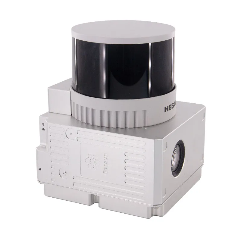
Geosun GS 260H 300m UAV LiDAR Mapping System
Get the best price for your setup
Contact our experts for the best possible price and configuration.
- Fast response
- Expert configuration advice
- No overpaying for features you do not need
The Geosun GS-260H is a lightweight mid-range UAV LiDAR mapping system for surveyors, drone operators, engineers and GIS professionals who need dense 3D data without carrying a heavy long-range payload. It combines a 32-channel Hesai laser scanner, gSpin 210 GNSS/INS positioning and a 26 MP RGB camera in a compact 1.1 kg system. With a maximum measuring range of 300 m, triple returns, up to 1.92 million points per second and absolute accuracy of up to 10 cm at 150 m, the GS-260H is well suited to topographic surveys, power-line corridors, forestry, mining, construction and urban mapping.
Geosun GS-260H Highlights
| Maximum LiDAR range | Up to 300 m |
|---|---|
| Absolute accuracy | 10 cm at 150 m |
| Laser channels | 32-channel LiDAR |
| Point rate | Up to 1,920,000 points/sec |
| Laser returns | Triple echo |
| Field of view | 360° × 40.3° |
| Camera | 26 MP RGB camera |
| Weight | Approx. 1.1 kg |
Valued customers:










Find RTK Networks
Search NTRIP providers and connect to reliable RTK correction services.
Description
Mid-range UAV LiDAR for professional aerial mapping
The Geosun GS-260H is an integrated airborne LiDAR system designed for surveyors, drone operators, engineers, construction teams and GIS professionals who need to collect detailed three-dimensional data efficiently from the air. The system combines a 32-channel laser scanner, GNSS satellite positioning, an inertial navigation system and a high-resolution RGB camera in one compact payload, allowing georeferenced point-cloud data and imagery to be collected during the same mission.
With a maximum measuring range of 300 m and a system weight of only around 1.1 kg, the GS-260H provides a useful balance between working distance and payload size. It is especially suited to projects where a compact low-altitude scanner does not provide enough range, but a much heavier long-range system would be unnecessary.
32-channel LiDAR with up to 1.92 million points per second
The GS-260H uses a 32-channel laser scanner capable of recording up to 1,920,000 points per second in triple-return operation. The high acquisition rate allows the system to capture dense terrain and object information while the aircraft is moving at normal survey speeds.
For practical mapping work, this gives survey teams enough point density to represent terrain, vegetation, infrastructure and structures in detail without needing to fly extremely slowly. Actual density still depends on altitude, speed, flight-line spacing and overlap.
300 metre maximum measuring range
The GS-260H provides a maximum LiDAR range of approximately 300 m. Geosun also specifies around 80 m at 10% target reflectivity, which illustrates how practical range changes with the surface being scanned.
This is important in fieldwork because darker vegetation, asphalt and low-reflectivity materials usually produce shorter usable ranges than brighter or more reflective surfaces. Flight altitude should therefore be selected around the actual project environment rather than the maximum sensor specification alone.
Triple returns for vegetation and complex scenes
The scanner supports triple laser echoes. A single pulse can therefore provide measurements from more than one surface when it passes through vegetation or encounters several objects at different heights.
For forestry and terrain surveys, this can provide additional information from the canopy, lower vegetation and surfaces underneath. Multiple returns are also useful for power lines and infrastructure, where wires, poles, vegetation and ground can occupy the same vertical space.
10 cm absolute accuracy at 150 metres
The current GS-260H specification gives an absolute accuracy of approximately 10 cm at 150 m. The LiDAR ranging accuracy itself is specified at approximately 0.5 cm, while final georeferenced accuracy also depends on GNSS and inertial positioning.
For surveyors, it is important to distinguish sensor ranging performance from total system accuracy. Flight height, GNSS correction quality, trajectory processing, aircraft motion, boresight calibration and project control can all influence the final point cloud.
gSpin 210 GNSS and INS positioning
The GS-260H integrates Geosun’s gSpin 210 GNSS/INS unit with a 200 Hz IMU update rate. The positioning system supports GPS, GLONASS, Galileo and BeiDou signals and records the position and attitude of the payload continuously throughout the flight.
The published specifications list position accuracy of ≤0.05 m, pitch and roll accuracy of 0.015° and heading accuracy of 0.040°. During processing, this trajectory information is combined with the LiDAR measurements so each point can be placed in the correct geographic position.
Wide 360 degree LiDAR coverage
The scanner provides approximately 360° horizontal coverage with a 40.3° vertical field of view. This scanning geometry allows the system to collect information not only directly beneath the aircraft but also on surrounding surfaces and vertical features.
This is useful when surveying building façades, utility structures, vegetation and complex terrain, where a narrow downward-looking scan may miss important geometry.
26 MP RGB camera for colourised point clouds
An integrated 26 MP RGB camera records imagery alongside the LiDAR data. The camera uses a 16 mm focal length in the current specification and provides visual information that can be used to colourise the point cloud and improve object recognition.
For surveyors and GIS users, colourised LiDAR makes it easier to identify roads, buildings, vegetation, cables and other features. Collecting imagery and LiDAR in the same mission can also reduce the need for a separate photographic survey.
Topographic surveying
For topographic projects, the GS-260H can collect a dense three-dimensional representation of the ground and surrounding features over a much larger area than conventional point-by-point field measurement. The resulting point cloud can support terrain models, site surveys, planning, engineering design and earthwork analysis.
The manufacturer provides an example point density of approximately 50 points/m² at 150 m altitude and 10 m/s. This provides a useful reference when estimating whether the system is suitable for the level of detail required on a specific project.
Power-line and utility corridor mapping
Power-line patrol is one of the main stated applications of the GS-260H. The combination of triple returns, 360° scanning and high point density allows conductors, poles, vegetation and surrounding terrain to be captured in three dimensions.
For utility teams, this can support corridor documentation, vegetation-clearance analysis and asset mapping while reducing the need to manually measure difficult-to-access features from the ground.
Forestry and vegetation surveys
The GS-260H is also designed for forestry and vegetation monitoring. Multiple laser returns can provide information from different canopy levels and, where openings exist, from the terrain beneath the vegetation.
This makes the system useful for generating terrain models, studying canopy structure and supporting forestry or land-management projects where both vegetation and ground geometry matter.
Mining and earthworks
Mining and construction teams can use the GS-260H to document open pits, excavation areas, stockpiles, slopes and changing terrain. Regular UAV flights can provide comparable point clouds for volume calculations and progress monitoring.
Because the payload is relatively light, it is practical for repeat surveys where frequent data collection is more useful than occasional flights with a heavier airborne system.
Urban mapping and construction projects
Geosun also positions the GS-260H for construction and smart-city applications. Its combination of LiDAR and RGB imagery allows buildings, roads, vegetation and urban infrastructure to be recorded in a single flight.
The wide scan geometry is especially useful around vertical structures. Geosun has demonstrated the system for building and park mapping at flight heights above the surrounding structures, producing complete coloured point clouds for 3D modelling.
Multi-rotor VTOL and vehicle compatibility
The GS-260H can be integrated with multi-rotor UAVs, VTOL aircraft and suitable vehicle platforms. This gives mapping companies flexibility to select the carrier according to the survey.
Multi-rotor drones are practical for construction sites and smaller areas where precise take-off and landing are important. VTOL aircraft are better suited to longer corridors and larger areas, while vehicle mounting allows the sensor to be used for suitable mobile-mapping projects.
Lightweight design for professional UAVs
At approximately 1.1 kg, the GS-260H is considerably lighter than many traditional airborne LiDAR systems. Its dimensions are approximately 14.4 × 10.9 × 12 cm, helping it fit professional UAV platforms without requiring an exceptionally large aircraft.
The system operates from a 12–24 V supply, consumes around 20 W and is designed for field use across a stated operating temperature range of approximately -20°C to +55°C.
Storage and field workflow
The GS-260H includes 64 GB of internal storage and supports up to a 128 GB TF card. This provides space for LiDAR, trajectory and image data during professional mapping missions.
Survey planning should account for flight duration, point density, image capture, storage and aircraft endurance so the complete project can be covered efficiently without unnecessary data gaps.
Point-cloud processing
After the flight, the GNSS/INS trajectory and LiDAR data are processed together to create a georeferenced point cloud. Geosun provides point-cloud processing software that synchronises trajectory, laser and camera information and outputs standard formats for further processing.
The processed data can then be used in compatible surveying, CAD, GIS, forestry, mining, engineering and point-cloud software depending on the required deliverables.
Who is the Geosun GS-260H for?
The GS-260H is particularly suitable for survey companies, construction professionals, UAV service providers, civil engineers, utilities, forestry specialists, mining companies and GIS teams that need more working range than a compact low-altitude LiDAR system can provide but still want to keep UAV payload weight low.
Its strongest combination is the 300 m maximum range, 1.92 million point-per-second acquisition rate, triple returns, integrated GNSS/INS and 1.1 kg weight. This makes it a practical mid-range option for professional aerial mapping.
Buying the Geosun GS-260H from Global GPS Systems
The correct LiDAR setup depends on required accuracy, point density, flight altitude, terrain, vegetation, aircraft capacity and final deliverables. Global GPS Systems can help determine whether the Geosun GS-260H fits your UAV and survey workflow and advise on the supporting GNSS, flight-planning and point-cloud processing setup for professional mapping projects.
Datasheets & Manuals
Specifications
Geosun GS-260H Specifications
General System
| Product Type | Middle-range UAV / mobile LiDAR scanning system |
|---|---|
| Model | GS-260H |
| Series | Geosun gAirHawk |
| Absolute Accuracy | 10 cm at 150 m |
| Point Cloud Density | 50 pts/m² at 150 m and 10 m/s |
| Weight | 1.1 kg |
| Dimensions | 14.4 × 10.9 × 12 cm |
| Operating Temperature | -20°C to +55°C |
| Input Voltage | 12–24 V |
| Power Consumption | 20 W |
| Carrying Platforms | Multi-rotor UAV, VTOL UAV and vehicle |
| Internal Data Storage | 64 GB |
| Maximum Storage Support | 128 GB TF card |
LiDAR Scanner
| LiDAR Sensor | HESAI XTM2X |
|---|---|
| Maximum Measuring Range | 300 m |
| Measuring Range at 10% Reflectivity | 80 m |
| Range Accuracy | 0.5 cm |
| Laser Line Number | 32 |
| LiDAR Channels | 32-channel |
| Maximum Point Rate | 1,920,000 points/second |
| Return Mode | Triple echo / 3 returns |
| Field of View | 360° × 40.3° |
| Horizontal Field of View | 360° |
| Scanning Frequency | 10 Hz / 20 Hz |
| Laser Wavelength | 905 nm |
| Laser Safety Class | Class 1 |
| Laser Safety Standard | IEC 60825-1:2014 |
POS / GNSS / IMU
| POS Model | gSpin 210 |
|---|---|
| Position Accuracy | ≤0.05 m |
| IMU Update Rate | 200 Hz |
| Pitch Accuracy | 0.015° |
| Roll Accuracy | 0.015° |
| Heading Accuracy | 0.040° |
| GNSS Constellations | GPS, GLONASS, Galileo and BeiDou |
| GPS Signals | L1 / L2 / L5 |
| GLONASS Signals | L1 / L2 |
| Galileo Signals | E1 / E5a / E5b |
| BeiDou Signals | B1C / B1 / B2 / B2a / B2b / B3 |
Camera
| Camera | Built-in synchronized camera |
|---|---|
| Camera Resolution | 26 MP |
| Focal Length | 16 mm |
| Camera Field of View | 80° |
| Trigger Modes | Distance trigger or time trigger |
| Synchronized Capture | Point cloud and image data |
| Point Cloud Colorization | Supported using synchronized camera imagery |
Data and Output
| LiDAR Data Rate | Up to 1,920,000 points/second |
|---|---|
| LiDAR Returns | 3 returns |
| Point Cloud Output Formats | LAS and custom TXT |
| POS Output Information | Position, speed and attitude |
| Image Capture | Synchronized with LiDAR acquisition |
| Trajectory Processing | GNSS / IMU trajectory processing supported |
| Motion Compensation | Supported during point cloud preprocessing |
Software
| Point Cloud Processing Software | Point Cloud Automata |
|---|---|
| Trajectory and Point Cloud Preprocessing | PointCloudCreater 2.1.3 supported |
| GNSS / IMU and LiDAR Synchronization | Supported |
| Trajectory Optimization | Supported |
| Point Cloud Preprocessing | Supported |
| Point Cloud Classification | Supported |
| Point Cloud Post-processing | Supported |
| Multi-Sensor Data Processing | GNSS, IMU, LiDAR and camera data |
| Large Dataset Processing | GPU acceleration supported |
Platform Compatibility
| Multi-Rotor UAV | Supported |
|---|---|
| VTOL UAV | Supported |
| Vehicle Installation | Supported |
| Airborne Mapping | Supported |
| Mobile Mapping | Supported |
Key Scanning Performance
| Parameter | Performance | Conditions / Notes |
|---|---|---|
| Maximum Range | 300 m | Maximum specified LiDAR range |
| Range at Low Reflectivity | 80 m | At 10% target reflectivity |
| Absolute Accuracy | 10 cm | At 150 m |
| Range Accuracy | 0.5 cm | Laser ranging accuracy |
| Point Cloud Density | 50 pts/m² | At 150 m altitude/range and 10 m/s travel speed |
| Point Rate | 1,920,000 points/second | Triple-return operation |
Typical Applications
| Topographic Surveying | Supported |
|---|---|
| Vegetation Monitoring | Supported |
| Forestry Surveying | Supported |
| Power Line Patrol | Supported |
| Mining Surveying | Supported |
| Construction Surveying | Supported |
| Urban Mapping | Supported |
| Smart City Mapping | Supported |
| Infrastructure Inspection | Supported |
| 3D Mapping | Supported |
Transport and Packaging
| Transport Case | Protective suitcase with EVA liner |
|---|---|
| Outer Packaging | Hard carton box |
| Suitcase Size | 450 × 365 × 200 mm |
Specifications and package contents may vary by configuration, region or manufacturer update. Always check the current configuration before ordering.
Reviews (0)
Only logged in customers who have purchased this product may leave a review.
FAQ
Geosun GS-260H FAQ
LiDAR Performance & Accuracy
What is the Geosun GS-260H?
The Geosun GS-260H is a lightweight medium-range LiDAR mapping system designed for professional aerial and mobile surveying. It combines a 32-line laser scanner, GNSS/INS positioning and a 26 MP camera to collect georeferenced point clouds and imagery for applications such as topographic surveying, forestry, mining, power line inspection, construction and urban mapping.
What is the maximum measuring range of the Geosun GS-260H?
The GS-260H has a specified maximum LiDAR measuring range of up to 300 metres. Actual usable range depends on factors such as target reflectivity, atmospheric conditions, scan geometry and the required point density.
What accuracy can the GS-260H achieve?
The GS-260H is specified with an absolute system accuracy of approximately 10 cm at a distance of 150 metres under suitable operating conditions. The laser scanner itself has a specified range accuracy of approximately 0.5 cm. Final survey accuracy also depends on GNSS conditions, trajectory processing, flight planning and project control.
How many points per second does the GS-260H collect?
The GS-260H can collect up to 1,920,000 LiDAR points per second when using its triple-return capability. This high acquisition rate enables dense point cloud collection from moving UAV, VTOL and vehicle platforms.
Does the Geosun GS-260H support multiple LiDAR returns?
Yes. The GS-260H supports up to three returns per laser pulse. Multiple returns are particularly useful when mapping vegetation because the system can record information from different levels of the canopy and surfaces beneath vegetation where laser penetration allows.
What field of view does the GS-260H have?
The GS-260H LiDAR scanner provides a 360-degree horizontal field of view with an approximately 40.3-degree vertical field of view. This enables wide-area point cloud acquisition as the sensor platform moves over or through the survey area.
GNSS, INS & Aerial Mapping
Does the GS-260H include GNSS and an IMU?
Yes. The GS-260H incorporates Geosun's gSpin 210 positioning and orientation system, combining GNSS and inertial measurement data to determine the sensor's position and orientation during data collection.
Which GNSS constellations does the GS-260H support?
The GS-260H supports multiple satellite constellations, including GPS, GLONASS, Galileo and BeiDou. Multi-constellation reception helps improve satellite availability and positioning performance during aerial and mobile LiDAR surveys.
What is the GNSS positioning accuracy of the GS-260H?
The integrated positioning system is specified with position accuracy of up to 0.05 metres under appropriate conditions. The complete LiDAR system has a separate specified absolute accuracy of approximately 10 cm at 150 metres because final point cloud accuracy also depends on sensor orientation, range measurement, trajectory quality and survey geometry.
What orientation accuracy does the GS-260H provide?
The integrated positioning system is specified with pitch and roll accuracy of approximately 0.015 degrees and heading accuracy of approximately 0.040 degrees. Accurate orientation measurements are important when converting airborne LiDAR measurements into correctly positioned 3D coordinates.
What is the IMU update rate of the GS-260H?
The GS-260H positioning system has a specified IMU update rate of 200 Hz. The high update rate helps track rapid platform movement and orientation changes during UAV and mobile mapping surveys.
Can the GS-260H be mounted on a drone?
Yes. The GS-260H is designed for integration with multi-rotor UAVs and VTOL platforms. Its approximately 1.1 kg system weight makes it suitable for professional drone mapping platforms that have sufficient payload capacity, power supply and compatible mounting hardware.
Applications & Survey Workflows
What is the Geosun GS-260H used for?
The GS-260H is designed for professional LiDAR mapping tasks including topographic surveys, forestry and vegetation monitoring, mining surveys, power line patrol, construction projects, infrastructure mapping and urban or smart-city mapping.
Is the GS-260H suitable for topographic surveying?
Yes. Topographic surveying is one of the primary applications of the GS-260H. Its combination of high-density LiDAR data, GNSS/INS positioning and aerial platform compatibility allows surveyors to efficiently capture terrain, structures and other surface features across large areas.
Can the GS-260H be used for forestry and vegetation surveys?
Yes. The GS-260H is suitable for forestry and vegetation mapping. Its high point acquisition rate and triple-return capability can help record information from different vegetation layers and, where sufficient laser pulses penetrate the canopy, provide terrain information beneath vegetation.
Can the GS-260H be used for power line inspection?
Yes. Power line patrol and corridor mapping are intended applications of the GS-260H. Aerial LiDAR can be used to capture conductors, poles, towers, terrain and surrounding vegetation for tasks such as corridor documentation, clearance analysis and infrastructure inspection.
Is the GS-260H suitable for mining surveys?
Yes. The GS-260H can be used for aerial mapping of mines, quarries, stockpiles and excavation areas. The resulting point clouds can support terrain modelling, surface documentation and volumetric analysis when processed with appropriate surveying software.
Can the GS-260H be used for construction and urban mapping?
Yes. Construction and urban planning are among the intended applications of the GS-260H. Its combination of LiDAR and synchronized imagery can provide detailed 3D datasets for site documentation, infrastructure mapping, progress surveys, terrain modelling and smart-city projects.
Camera, Hardware & Data Processing
Does the Geosun GS-260H include a camera?
Yes. The GS-260H includes a 26 MP camera with a specified 16 mm focal length. The camera captures imagery synchronized with the LiDAR survey, allowing image information and 3D point cloud data to be used together during post-processing and visualisation.
How much does the GS-260H weigh?
The GS-260H weighs approximately 1.1 kg. Its relatively low weight is designed to make integration practical on professional UAV and VTOL platforms while leaving payload capacity available for mounting and power components.
What are the dimensions of the GS-260H?
The GS-260H measures approximately 14.4 × 10.9 × 12 cm. Its compact dimensions help simplify installation on aerial and mobile mapping platforms.
Can the GS-260H also be mounted on a vehicle?
Yes. In addition to multi-rotor UAV and VTOL integration, the GS-260H supports vehicle-mounted operation. This makes the system usable for both aerial LiDAR mapping and suitable mobile mapping applications.
What power supply does the GS-260H require?
The GS-260H operates from a 12 V to 24 V power supply and has a specified power consumption of approximately 20 W. The host UAV, VTOL or vehicle must provide a suitable and stable power source for the sensor system.
How much data storage does the GS-260H have?
The GS-260H is specified with 64 GB of data storage and supports TF cards with capacities up to 128 GB. Required storage capacity depends on survey duration, LiDAR acquisition settings and the amount of imagery collected.
What software is used to process GS-260H LiDAR data?
Geosun provides Point Cloud Automata software for point cloud post-processing and classification workflows. Depending on the required deliverables, processed GS-260H data can subsequently be used with compatible surveying, GIS, CAD, point cloud and 3D modelling software.
 GPS & GNSS
 Total Stations
 Data collectors
 Software
 Correction services
 Machine control
 External radio
 Marine
 Accessories
Reviews
There are no reviews yet