

 GPS & GNSS
 Lidar scanning
 Total Station
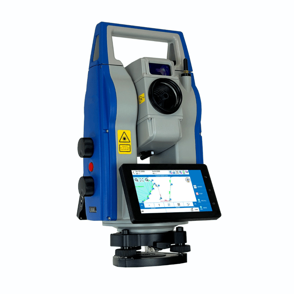
Carlson CRT Robotic Total Station with Android and Fast360
Get the best price for your setup
Contact our experts for the best possible price and configuration.
- Fast response
- Expert configuration advice
- No overpaying for features you do not need
The Carlson CRT is a high-precision Android robotic total station for surveying, construction layout and engineering work. Available with 0.5″ or 1″ angular accuracy, it combines fast TDrive motorisation, automatic prism centring and Fast360 prism search with accurate long-range EDM measurement. It is designed for professional one-person surveying as well as onboard operation directly from the instrument.
With prism measurements up to 6000 m, reflectorless measurement up to 1000 m and 1 mm + 1 ppm prism EDM accuracy, the CRT is suited to precise setting out, control, topographic surveying and as-built work. Dual 6-inch Android touchscreens, an onboard camera, guide light and Carlson Layout provide a modern field workflow, while long-range Bluetooth supports remote control from a compatible field controller.
Carlson CRT Highlights
| Angular accuracy | 0.5″ or 1″ versions |
|---|---|
| Prism range | Up to 6000 m |
| Reflectorless range | Up to 1000 m |
| Distance accuracy | 1 mm + 1 ppm with prism |
| Robotic system | TDrive motor with automatic prism centring and Fast360 search |
| Rotation speed | Up to 180°/sec |
| Field interface | Android with dual 6-inch colour touchscreens and Carlson Layout |
| Field protection | IP65 |
Valued customers:










Find RTK Networks
Search NTRIP providers and connect to reliable RTK correction services.
Description
Carlson CRT High Precision Robotic Total Station
The Carlson CRT is a professional robotic total station developed for surveyors, construction crews and engineers who need accurate measurements combined with fast automated prism handling. Available in 0.5″ and 1″ angular accuracy versions, the CRT is designed for demanding setting out, control, topographic survey and as-built work where both precision and field speed matter.
Unlike a conventional manual total station, the CRT can automatically search for and centre on a prism. This allows the surveyor to work at the prism pole while the instrument follows the target, reducing the need to repeatedly return to the total station. For construction crews this can make repetitive stakeout work more practical, while surveyors can collect points efficiently with a one-person field setup.
Fast TDrive Robotic Motor
The CRT uses Carlson’s TDrive motor system with a maximum rotation speed of 180° per second. In practice, this allows the instrument to turn rapidly when moving between targets or following a prism around a jobsite. The drive system is designed for smooth and quiet robotic movement, helping the total station respond quickly as the operator changes position.
Fast motorisation becomes especially useful during stakeout, road and infrastructure work, site surveys and projects where many individual points need to be measured. Instead of manually rotating the telescope for every observation, the robotic system takes care of much of the instrument movement.
Automatic Prism Centring and Fast360 Search
The CRT combines automatic prism centring with Fast360 target search. Automatic centring helps the telescope accurately align itself with the prism after the target is located. If the prism is temporarily lost because a vehicle, person or site object interrupts the line of sight, the robotic search system helps the instrument find the target again.
This makes the CRT particularly useful on active construction sites, where maintaining an uninterrupted line of sight is not always possible. The system also reduces the amount of manual telescope aiming required during normal fieldwork.
High Accuracy Prism Measurements
For precision work with a prism, the Carlson CRT provides a measurement range of up to 6000 metres and specified distance accuracy of 1 mm + 1 ppm. The combination of precise angular measurement and high-quality EDM makes the CRT suitable for survey control, structural layout, engineering surveys and other applications where small positioning errors can affect the final result.
The instrument is offered in both 0.5″ and 1″ angular versions. The appropriate model depends on the tolerances of the work being carried out. Survey control and specialised engineering work may benefit from the 0.5″ option, while the 1″ model remains suitable for a broad range of professional survey and construction tasks.
Measure Up to 1000 Metres Without a Prism
The CRT can also measure reflectorless distances of up to 1000 metres under suitable conditions. Reflectorless measurement is useful when placing a prism directly on the required point is difficult, unsafe or simply inefficient.
Typical examples include building façades, overhead structures, inaccessible corners, roofs, stockpiles, walls and objects across restricted areas. Surveyors can point the telescope at the required surface and collect the distance without physically reaching it. This can reduce setup time and provides another measurement method alongside normal prism work.
Android Total Station with Dual Touchscreens
The Carlson CRT runs on Android and has two 6-inch colour touchscreens. This provides a familiar interface for field crews who already work with Android survey controllers and allows the instrument to be operated directly without always requiring a separate data collector.
The onboard Carlson Layout software supports total station fieldwork directly on the CRT. Measurements and project information can therefore be handled at the instrument when that is the most practical setup. The CRT also includes 3 GB of RAM and 32 GB of internal storage for its operating environment and field applications.
Built In Camera and Guide Light
An onboard camera adds visual information to the robotic workflow and can help the operator understand what the telescope is pointing toward without always looking through the eyepiece. The electronic guide light provides an additional visual reference for the person carrying the prism.
During construction stakeout, the guide light helps the prism operator move toward the instrument’s line of sight. This makes it easier to position the pole before the final coordinate guidance is used to reach the required point.
Remote One Person Surveying
The CRT can be operated remotely using a compatible external controller and Carlson field software. Long-range Bluetooth provides communication between the instrument and controller, allowing the surveyor to carry the controller at the prism pole and send commands back to the total station.
This configuration is well suited to one-person surveying. The operator can move between survey points, trigger measurements, perform stakeout routines and manage project data without having a second person permanently stationed behind the total station. Current Carlson configuration guidance uses SurvPC 7.12 or later for remote CRT operation.
Combine Total Station and RTK GNSS Work
The Carlson CRT can also form part of a combined total station and GNSS workflow. Carlson’s One-Pole configuration is designed so Layout or SurvPC can work with both the robotic total station and a compatible GNSS receiver within the same project.
This is useful because GNSS and total stations solve different field problems. RTK GNSS is efficient in open areas with good satellite visibility, while the CRT can continue providing precise measurements close to buildings, beneath structures or in other places where GNSS performance may be limited. A combined workflow allows the field crew to select the measurement method that best suits each point.
For surveyors and construction teams already using RTK GNSS, this can also simplify mixed projects such as site control, road construction, utilities, foundation layout and as-built verification. Drone and mapping teams can use precise total station observations when establishing or checking ground control where required.
Practical Data Transfer in the Field
The Android platform supports several ways of moving project data. Files can be transferred using USB, cable connection, Bluetooth or Wi-Fi, making it easier to move survey information between the instrument, controller and office computer.
This flexibility is useful for crews working across different projects and software environments because data does not have to depend on a single transfer method. Integrated wireless connectivity also supports the remote field workflow used with Carlson software.
Designed for Real Survey and Construction Environments
The CRT has an IP65 environmental protection rating and is specified to operate from -20°C to +50°C. A dual-axis compensator helps correct small instrument levelling errors in the horizontal and vertical angle readings, while the laser plummet assists with positioning the instrument accurately over a known survey point.
Each battery provides a specified operating time of approximately six hours depending on use and display settings, and the system uses interchangeable rechargeable Li-ion batteries. This makes it possible to continue working by changing batteries rather than stopping the complete survey setup for charging.
Typical Carlson CRT Applications
The combination of high angular accuracy, precise EDM measurement and robotic prism handling makes the CRT suitable for a wide range of professional measurement tasks.
- Construction layout and stakeout
- Topographic and detail surveying
- Survey control and traversing
- Road and infrastructure construction
- Engineering and structural measurement
- As-built surveys and position checks
- Ground control for mapping and related survey projects
Choosing the Right Carlson CRT Setup
The most suitable CRT configuration depends on the required angular accuracy, field software, controller and whether the instrument will mainly be operated onboard or as a remote robotic system. A crew focused on very tight engineering tolerances may have different requirements from a contractor primarily carrying out everyday construction layout.
Global GPS Systems can help configure the Carlson CRT around the way your crew actually works, including the correct controller, prism, pole, tripod, field software and compatible GNSS equipment. This makes it easier to build a complete measurement system for surveying, construction and mixed GNSS and total station workflows.
Datasheets & Manuals
Specifications
Carlson CRT Series Robotic Total Station FAQ
Carlson CRT Series & Applications
What is the Carlson CRT Series?
The Carlson CRT Series is a high-precision Android robotic total station designed for professional surveying, engineering and construction layout. It combines automatic prism aiming and searching, high-speed TDrive motorisation, long-range reflectorless measurement, onboard field software and wireless connectivity in a single instrument.
Who is the Carlson CRT robotic total station designed for?
The Carlson CRT is designed for land surveyors, civil engineers, construction layout crews, infrastructure contractors and other professionals who need precise angle and distance measurements. Its robotic operation is particularly useful for crews that want to perform surveying and stakeout with a single operator.
What can the Carlson CRT Series be used for?
Typical applications include topographic surveying, construction stakeout, building layout, road and infrastructure work, as-built surveys, control surveys, engineering measurements, monitoring and other projects requiring precise total station measurements.
Can the Carlson CRT be operated by one person?
Yes. The CRT is a robotic total station that can automatically search for, aim at and follow a prism. When used with compatible Carlson field software and a field controller, the surveyor can control the total station from the prism position, making efficient one-person surveying and stakeout possible.
What angular accuracy options are available for the Carlson CRT?
The Carlson CRT datasheet lists 0.5-second and 1-second angular accuracy versions. These high-precision configurations are intended for applications where accurate angle measurements are important, including control, engineering, deformation monitoring and precision construction work. Available configurations can vary by market.
What is the difference between the Carlson CRT and a manual total station?
A manual total station requires the operator to aim the telescope at the target manually. The Carlson CRT uses motorised robotic technology to automatically search for, aim at and follow a prism. This allows the instrument to be remotely controlled and can remove the need for a second person to remain at the total station during many surveying tasks.
Accuracy, EDM & Robotic Tracking
How accurate is the Carlson CRT when measuring to a prism?
The Carlson CRT specifies a standard prism distance accuracy of 1 mm + 1 ppm under suitable measurement conditions. This makes it suitable for high-precision surveying, engineering and construction applications.
How far can the Carlson CRT measure with a prism?
The CRT can measure distances of up to approximately 6,000 metres in standard prism mode under suitable conditions. Actual usable range depends on the prism, atmospheric conditions, visibility and the measurement environment.
Can the Carlson CRT measure without a prism?
Yes. The Carlson CRT supports reflectorless EDM measurements, allowing points to be measured directly on suitable surfaces without placing a prism on the target. This is useful for façades, structures, inaccessible points, overhead features and locations that are unsafe or difficult to reach.
What is the reflectorless range and accuracy of the Carlson CRT?
The CRT datasheet specifies reflectorless measurements up to approximately 1,000 metres under optimal conditions on a suitable surface. Reflectorless distance accuracy is specified at 2 mm + 2 ppm. Surface colour, texture, angle, atmospheric conditions and distance can all influence reflectorless performance.
What is TDrive technology on the Carlson CRT?
TDrive is the high-speed motor system used to rotate and control the CRT. It provides rotation speeds of up to 180 degrees per second and uses a gearless design intended to provide smooth and quiet movement with reduced mechanical friction. The high rotation speed helps the instrument rapidly search for and follow a moving prism.
How does the Carlson CRT automatically aim at a prism?
The CRT uses automatic prism centring technology to identify and precisely aim at a target. Carlson specifies an automatic prism centring range of approximately 1.5 to 1,000 metres under suitable conditions, helping automate measurements and robotic tracking.
What is Fast360° prism search on the Carlson CRT?
Fast360° is the CRT's automatic target-search technology. If prism lock is lost, the system can search around the instrument to relocate the target instead of requiring the operator to manually aim the telescope. Carlson documentation specifies Fast360° searching over a 360-degree horizontal area, with search range depending on operating conditions and configuration.
Android, Carlson Software & Connectivity
Does the Carlson CRT have an onboard operating system?
Yes. The Carlson CRT uses an Android operating system and has two 6-inch colour touchscreen displays with a resolution of 720 x 1280 pixels. The Android interface allows field applications to be operated directly on the total station.
Can surveying software run directly on the Carlson CRT?
Yes. The CRT supports Carlson field software for onboard operation. Carlson documentation describes Carlson Layout as the onboard field application, providing total station surveying and construction layout functionality directly from the instrument's touchscreen.
Does the Carlson CRT work with Carlson SurvPC?
Yes. The Carlson CRT can be controlled from an external Windows field computer running Carlson SurvPC. Carlson specifies SurvPC 7.12 or later for current CRT support. The instrument is selected as a Carlson Robotic CRT within SurvPC.
Can the Carlson CRT be combined with a GNSS receiver?
Yes. Carlson field software supports workflows that combine total station and GNSS measurements within the same project. A compatible GNSS receiver can be used where satellite positioning is suitable, while the CRT can be used where optical measurements provide better access or precision. Available hybrid functions depend on the field software and license configuration.
How does a data collector connect to the Carlson CRT?
The CRT includes long-range Bluetooth for communication with a compatible external field controller. Carlson documentation specifies communication at distances up to approximately 300 metres under suitable conditions, allowing the operator to control the robotic total station remotely from the prism.
What connectivity does the Carlson CRT provide?
The CRT supports long-range Bluetooth, WLAN/Wi-Fi, integrated 4G, hotspot functionality, RS-232 and USB connectivity. These interfaces support remote instrument control, field data transfer and connected surveying workflows.
Camera, Battery & Field Durability
Does the Carlson CRT have a built-in camera?
Yes. The Carlson CRT includes an onboard camera. Together with the instrument's touchscreen displays, the camera can assist the operator with field operation and target-related workflows.
What is the guide light on the Carlson CRT used for?
The CRT includes an electronic guide light that helps the prism operator position themselves relative to the telescope's line of sight. This is particularly useful during construction stakeout because it provides a visual indication that can help the operator move toward the required alignment.
Does the Carlson CRT have a laser plummet?
Yes. The CRT has an adjustable laser plummet for positioning the total station over a survey point. Carlson specifies a laser plummet accuracy of approximately 1 mm at an instrument height of 1.5 metres.
How long does the Carlson CRT battery last?
The CRT uses a removable 14.4 V, 6400 mAh lithium-ion battery. Carlson specifies approximately 6 hours of operation from one battery under suitable conditions. Actual operating time depends on factors including display brightness, motor use, robotic tracking, distance measurements, wireless connectivity and temperature.
Does the Carlson CRT come with more than one battery?
Carlson's CRT documentation lists two rechargeable lithium-ion batteries in the instrument carrying case. Each battery is specified for approximately 6 hours of operation under suitable conditions, allowing a charged spare battery to be carried for longer field sessions.
Is the Carlson CRT suitable for rain, dust and demanding field conditions?
Yes. The CRT is designed for professional outdoor use. Carlson documentation specifies IP65 protection against dust and water for the standard configuration, while some documentation notes that an IP66 configuration may be available depending on the ordered version. The specified operating temperature range is approximately -20°C to +50°C.
Reviews (0)
Only logged in customers who have purchased this product may leave a review.
FAQ
Carlson CRT Series Robotic Total Station FAQ
Carlson CRT Series & Applications
What is the Carlson CRT Series?
The Carlson CRT Series is a high-precision Android robotic total station designed for professional surveying, engineering and construction layout. It combines automatic prism aiming and searching, high-speed TDrive motorisation, long-range reflectorless measurement, onboard field software and wireless connectivity in a single instrument.
Who is the Carlson CRT robotic total station designed for?
The Carlson CRT is designed for land surveyors, civil engineers, construction layout crews, infrastructure contractors and other professionals who need precise angle and distance measurements. Its robotic operation is particularly useful for crews that want to perform surveying and stakeout with a single operator.
What can the Carlson CRT Series be used for?
Typical applications include topographic surveying, construction stakeout, building layout, road and infrastructure work, as-built surveys, control surveys, engineering measurements, monitoring and other projects requiring precise total station measurements.
Can the Carlson CRT be operated by one person?
Yes. The CRT is a robotic total station that can automatically search for, aim at and follow a prism. When used with compatible Carlson field software and a field controller, the surveyor can control the total station from the prism position, making efficient one-person surveying and stakeout possible.
What angular accuracy options are available for the Carlson CRT?
The Carlson CRT datasheet lists 0.5-second and 1-second angular accuracy versions. These high-precision configurations are intended for applications where accurate angle measurements are important, including control, engineering, deformation monitoring and precision construction work. Available configurations can vary by market.
What is the difference between the Carlson CRT and a manual total station?
A manual total station requires the operator to aim the telescope at the target manually. The Carlson CRT uses motorised robotic technology to automatically search for, aim at and follow a prism. This allows the instrument to be remotely controlled and can remove the need for a second person to remain at the total station during many surveying tasks.
Accuracy, EDM & Robotic Tracking
How accurate is the Carlson CRT when measuring to a prism?
The Carlson CRT specifies a standard prism distance accuracy of 1 mm + 1 ppm under suitable measurement conditions. This makes it suitable for high-precision surveying, engineering and construction applications.
How far can the Carlson CRT measure with a prism?
The CRT can measure distances of up to approximately 6,000 metres in standard prism mode under suitable conditions. Actual usable range depends on the prism, atmospheric conditions, visibility and the measurement environment.
Can the Carlson CRT measure without a prism?
Yes. The Carlson CRT supports reflectorless EDM measurements, allowing points to be measured directly on suitable surfaces without placing a prism on the target. This is useful for façades, structures, inaccessible points, overhead features and locations that are unsafe or difficult to reach.
What is the reflectorless range and accuracy of the Carlson CRT?
The CRT datasheet specifies reflectorless measurements up to approximately 1,000 metres under optimal conditions on a suitable surface. Reflectorless distance accuracy is specified at 2 mm + 2 ppm. Surface colour, texture, angle, atmospheric conditions and distance can all influence reflectorless performance.
What is TDrive technology on the Carlson CRT?
TDrive is the high-speed motor system used to rotate and control the CRT. It provides rotation speeds of up to 180 degrees per second and uses a gearless design intended to provide smooth and quiet movement with reduced mechanical friction. The high rotation speed helps the instrument rapidly search for and follow a moving prism.
How does the Carlson CRT automatically aim at a prism?
The CRT uses automatic prism centring technology to identify and precisely aim at a target. Carlson specifies an automatic prism centring range of approximately 1.5 to 1,000 metres under suitable conditions, helping automate measurements and robotic tracking.
What is Fast360° prism search on the Carlson CRT?
Fast360° is the CRT's automatic target-search technology. If prism lock is lost, the system can search around the instrument to relocate the target instead of requiring the operator to manually aim the telescope. Carlson documentation specifies Fast360° searching over a 360-degree horizontal area, with search range depending on operating conditions and configuration.
Android, Carlson Software & Connectivity
Does the Carlson CRT have an onboard operating system?
Yes. The Carlson CRT uses an Android operating system and has two 6-inch colour touchscreen displays with a resolution of 720 x 1280 pixels. The Android interface allows field applications to be operated directly on the total station.
Can surveying software run directly on the Carlson CRT?
Yes. The CRT supports Carlson field software for onboard operation. Carlson documentation describes Carlson Layout as the onboard field application, providing total station surveying and construction layout functionality directly from the instrument's touchscreen.
Does the Carlson CRT work with Carlson SurvPC?
Yes. The Carlson CRT can be controlled from an external Windows field computer running Carlson SurvPC. Carlson specifies SurvPC 7.12 or later for current CRT support. The instrument is selected as a Carlson Robotic CRT within SurvPC.
Can the Carlson CRT be combined with a GNSS receiver?
Yes. Carlson field software supports workflows that combine total station and GNSS measurements within the same project. A compatible GNSS receiver can be used where satellite positioning is suitable, while the CRT can be used where optical measurements provide better access or precision. Available hybrid functions depend on the field software and license configuration.
How does a data collector connect to the Carlson CRT?
The CRT includes long-range Bluetooth for communication with a compatible external field controller. Carlson documentation specifies communication at distances up to approximately 300 metres under suitable conditions, allowing the operator to control the robotic total station remotely from the prism.
What connectivity does the Carlson CRT provide?
The CRT supports long-range Bluetooth, WLAN/Wi-Fi, integrated 4G, hotspot functionality, RS-232 and USB connectivity. These interfaces support remote instrument control, field data transfer and connected surveying workflows.
Camera, Battery & Field Durability
Does the Carlson CRT have a built-in camera?
Yes. The Carlson CRT includes an onboard camera. Together with the instrument's touchscreen displays, the camera can assist the operator with field operation and target-related workflows.
What is the guide light on the Carlson CRT used for?
The CRT includes an electronic guide light that helps the prism operator position themselves relative to the telescope's line of sight. This is particularly useful during construction stakeout because it provides a visual indication that can help the operator move toward the required alignment.
Does the Carlson CRT have a laser plummet?
Yes. The CRT has an adjustable laser plummet for positioning the total station over a survey point. Carlson specifies a laser plummet accuracy of approximately 1 mm at an instrument height of 1.5 metres.
How long does the Carlson CRT battery last?
The CRT uses a removable 14.4 V, 6400 mAh lithium-ion battery. Carlson specifies approximately 6 hours of operation from one battery under suitable conditions. Actual operating time depends on factors including display brightness, motor use, robotic tracking, distance measurements, wireless connectivity and temperature.
Does the Carlson CRT come with more than one battery?
Carlson's CRT documentation lists two rechargeable lithium-ion batteries in the instrument carrying case. Each battery is specified for approximately 6 hours of operation under suitable conditions, allowing a charged spare battery to be carried for longer field sessions.
Is the Carlson CRT suitable for rain, dust and demanding field conditions?
Yes. The CRT is designed for professional outdoor use. Carlson documentation specifies IP65 protection against dust and water for the standard configuration, while some documentation notes that an IP66 configuration may be available depending on the ordered version. The specified operating temperature range is approximately -20°C to +50°C.

 GPS & GNSS
 Total Stations
 Data collectors
 Software
 Correction services
 Machine control
 External radio
 Marine
 Accessories
Reviews
There are no reviews yet