


 GPS & GNSS
 Lidar scanning
 Total Station


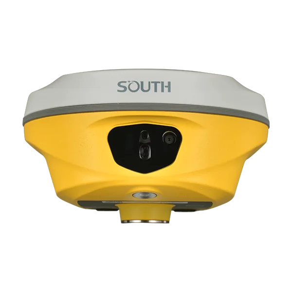
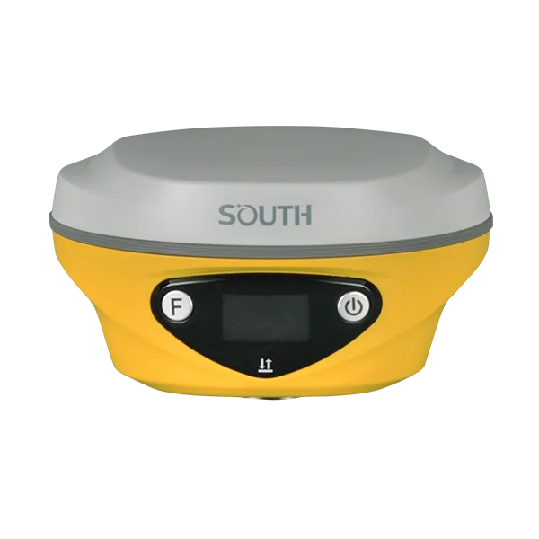


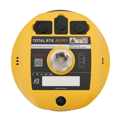
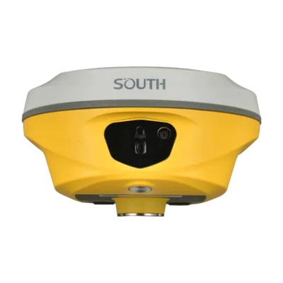

South ALPS1 Rover Base Set Laser RTK GNSS with IMU
Get the best price for your setup
Contact our experts for the best possible price and configuration.
- Fast response
- Expert configuration advice
- No overpaying for features you do not need
The South ALPS1 Rover Base Set is a complete RTK GNSS solution for surveyors, construction teams, GIS users and drone mapping professionals who need accurate positioning without depending only on an RTK network. With a rover and base receiver setup, laser measurement, visual positioning and 60° IMU tilt compensation, the ALPS1 helps you measure points faster in open sites, near obstacles, on slopes and in locations where standard pole work is difficult.
This set is especially useful for field crews working on construction layout, topographic surveys, road work, forestry, utility mapping, UAV ground control and general RTK surveying. The laser and camera functions make it easier to collect points from a safe distance, while the UHF radio connection supports independent rover-base operation on remote jobsites.
South ALPS1 Rover Base Set Highlights
| GNSS Channels | 1698 channels |
|---|---|
| Tilt Measurement | Calibration-free IMU tilt compensation up to 60° |
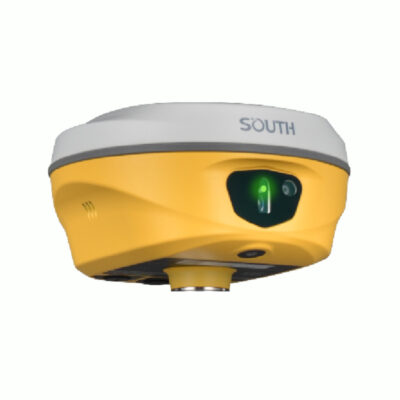
| Laser Surveying | 3R green laser for remote measurement and laser stakeout |
| Visual Positioning | Video shooting, 8MP camera and 2MP AR stakeout camera |
| Rover Base Communication | Internal UHF 410–470 MHz with Farlink radio protocol |
Valued customers:










Find RTK Networks
Search NTRIP providers and connect to reliable RTK correction services.
Description
South ALPS1 Rover Base Set for RTK Surveying and Construction Layout
The South ALPS1 Rover Base Set is built for professionals who want a complete RTK GNSS system with more flexibility than a rover-only setup. One receiver can be used as the base station and the other as the rover, making the system suitable for private construction sites, rural work areas, infrastructure projects and locations where mobile internet or RTK network coverage is not always reliable.
For surveyors, engineers, construction workers, drone pilots and GIS teams, the ALPS1 combines modern GNSS positioning with practical field tools such as laser measurement, visual positioning, CAD AR stakeout and IMU tilt compensation. Instead of only measuring points directly under the pole, users can also capture difficult or unsafe points from a distance, work around obstructions and complete stakeout tasks with clearer visual guidance.
Designed for Real Field Conditions
On many jobsites, measuring is not as simple as placing a pole on every point. Targets may be close to traffic, behind fences, under roof edges, near water, in narrow alleys or surrounded by trees and buildings. The South ALPS1 helps solve these everyday problems by combining RTK positioning with laser and camera-based workflows.
The laser measurement function allows users to measure points without physically standing on the target. This can save time when collecting points in tight spaces or when a point is unsafe or inconvenient to reach. Visual positioning also supports photo and video-based measurement, helping teams collect more information from the surrounding scene and return to stored image data when needed.
Laser Measurement and Visual Positioning
The ALPS1 is more than a standard GNSS rover. Its laser measurement function gives field crews a wider working range when measuring objects, corners, road features, trees, structures or points with limited access. This is useful for construction layout, as-built checks, utility mapping and general topographic work where not every point can be measured by placing the pole directly on it.
Visual positioning adds another layer of flexibility. By using image and video data together with RTK positioning, the ALPS1 can help users capture coordinates for difficult points such as corners under roofs, obstructed areas and locations where conventional RTK work is slower. This is especially valuable for teams that need to collect site data quickly while reducing unnecessary movement around the jobsite.
60° IMU Tilt Compensation for Faster Point Collection
The built-in IMU tilt compensation helps users measure accurately without keeping the pole perfectly level for every point. This is useful on slopes, around obstacles, beside walls, near trenches and in busy construction environments where leveling the pole takes extra time. For crews doing many points per day, tilt measurement can make the workflow smoother and reduce repeated setup movements.
Because the ALPS1 supports tilt measurement up to 60°, users can keep working in areas where a straight vertical pole position is difficult. This is helpful for both experienced surveyors and construction teams who want a faster and more practical way to collect points in the field.
CAD AR Stakeout for Clearer Layout Work
Stakeout is easier when the operator can see where to go. The South ALPS1 supports CAD AR stakeout, combining design data with the real jobsite view. This helps users understand the direction and location of the target more naturally, which is useful for construction layout, road work, site preparation, utility points and setting out design positions.
The dual-camera setup supports both general direction finding and closer target approach. This makes stakeout more visual and reduces guesswork, especially for users who are newer to RTK equipment or who need to work quickly on busy sites.
Independent Rover and Base Operation
A rover and base set is a strong choice when you do not want to rely only on a correction network. The South ALPS1 includes internal UHF radio communication, allowing the base station to send corrections to the rover. This is useful for remote worksites, large private construction areas, agricultural projects, forestry, infrastructure work and other locations where internet-based corrections are not always available.
The system also supports modern connectivity options such as 4G, Wi-Fi and Bluetooth, giving teams flexibility depending on the project, controller, software workflow and available correction source.
Who Uses the South ALPS1 Rover Base Set?
The South ALPS1 Rover Base Set is suitable for a wide range of professionals who need accurate GNSS positioning in the field. Land surveyors can use it for topographic surveys, control work, stakeout and as-built measurements. Construction teams can use it for layout, road measurements, earthwork checks and site documentation. GIS users can collect accurate asset and infrastructure data. Drone pilots can use it for ground control points and checking areas where UAV data needs extra support.
Forestry and environmental teams can also benefit from the laser and visual measurement functions, especially when measuring around trees, natural features and areas where access is limited. For public works, utilities and infrastructure projects, the ability to measure from a distance can help improve both speed and safety.
Complete Field Set with Controller and Accessories
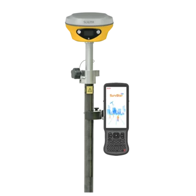
The rover base set is configured as a practical field package, including the receiver setup and essential accessories for daily surveying. Depending on the selected configuration, the set can include a South data collector, SurvStar surveying software, pole, controller bracket, tripod, tribrach and adapter. This makes it easier to start working with a complete RTK setup instead of building the kit piece by piece.
For buyers who already have a preferred controller, tablet or software workflow, Global GPS Systems can help check the best configuration for the way your team works. This is useful when comparing rover-only systems, rover-base sets, RTK network workflows and software compatibility.
Practical Benefits in the Field
- Work independently with a rover and base setup when RTK network access is limited.
- Measure difficult points with laser and visual positioning instead of always placing the pole directly on the target.
- Use IMU tilt compensation to collect points faster around obstacles and uneven ground.
- Improve stakeout workflow with CAD AR guidance and camera support.
- Use one system across surveying, construction, GIS, forestry and UAV mapping tasks.
Why Buy from Global GPS Systems?
Global GPS Systems supplies RTK GNSS equipment to professionals worldwide and helps buyers choose the right setup for their work. With the South ALPS1 Rover Base Set, the main question is not only whether the receiver is accurate, but whether the complete workflow fits your jobsite, correction method, software preference and team experience.
Whether you are a surveyor comparing advanced RTK systems, a construction company looking for a practical layout solution, or a drone pilot who needs reliable ground control, Global GPS Systems can help you select the right configuration and accessories for your fieldwork.
Specifications
South ALPS1 Rover Base Set Specifications
Product Overview
| Product Type | RTK GNSS rover and base set for land surveying, construction, forestry, UAV mapping and field data collection |
|---|---|
| Receiver Model | South ALPS1 Total RTK GNSS receiver |
| Set Configuration | Rover and base GNSS receiver set with field controller, surveying software and field accessories |
| Main Functions | RTK GNSS positioning, base/rover operation, IMU tilt measurement, visual positioning, video/photo measurement, AR stakeout, laser measurement and remote laser stakeout |
| Typical Applications | Control survey, road and construction surveying, CORS/NTRIP field work, data acquisition, stakeout, power-line measurement, forestry measurement, UAV mapping support and marine-related positioning tasks |
| Supported Workflow Features | CAD AR stakeout, photogrammetry/image measurement, 3D modeling support, laser point survey, laser distance survey, laser intersection and laser point stakeout |
GNSS Tracking
| Channels | 1698 |
|---|---|
| GPS | L1C, L1C/A, L2C, L2P(Y), L5 |
| GLONASS | G1, G2, G3 |
| BeiDou / BDS | B1I, B2I, B3I, B1C, B2a, B2b |
| Galileo | E1, E5a, E5b, E6, AltBOC* |
| SBAS | L1* |
| IRNSS | L5* |
| QZSS | L1, L2C, L5* |
| MSS L-Band | Reserved / future upgrade depending on configuration |
| Positioning Output Rate | 1 Hz to 20 Hz |
| Initialization Time | < 10 seconds |
| Initialization Reliability | > 99.99% |
Positioning Accuracy
| Mode | Horizontal Accuracy | Vertical Accuracy |
|---|---|---|
| Code Differential GNSS | 0.25 m + 1 ppm RMS | 0.50 m + 1 ppm RMS |
| GNSS Static | 2.5 mm + 0.5 ppm RMS | 3.5 mm + 0.5 ppm RMS |
| Static Long Observation | 2.5 mm + 0.1 ppm RMS | 3 mm + 0.4 ppm RMS |
| Rapid Static | 2.5 mm + 0.5 ppm RMS | 5 mm + 0.5 ppm RMS |
| PPK | 3 mm + 1 ppm RMS | 5 mm + 1 ppm RMS |
| RTK UHF | 8 mm + 1 ppm RMS | 15 mm + 1 ppm RMS |
| RTK NTRIP | 8 mm + 0.5 ppm RMS | 15 mm + 0.5 ppm RMS |
| SBAS Positioning | Typically < 5 m 3D RMS | |
RTK, IMU and Tilt Measurement
| RTK Initialization Time | 2 to 8 seconds |
|---|---|
| IMU Module | Built-in calibration-free IMU module |
| IMU Tilt Angle | 0° to 60° / optimal accuracy within 60° according to the linked product datasheet and technician manual |
| IMU Accuracy | 8 mm + 0.7 mm/° tilt |
| Tilt Initialization | Required for AR stakeout, photogrammetry and laser survey workflows |
| Electronic Bubble | Controller software can display the pole leveling status in real time |
Visual Positioning, Camera and AR Functions
| Visual Positioning | Supports photo and video-based coordinate capture using RTK positioning, IMU and camera data |
|---|---|
| Video Shooting Camera | 8 MP visual positioning camera, also usable for AR stakeout |
| AR Stakeout Camera | 2 MP camera |
| AR Stakeout | Supports real-scene visual stakeout with camera guidance and voice prompts |
| CAD AR Stakeout | Can integrate CAD drawing content with real-world camera scenes for more intuitive stakeout |
| Photogrammetry Modes | Photo mode, video mode and modeling for post-processing |
| Online Image Processing | Cloud/server processing supported when internet connection is available |
| Offline Image Processing | Local controller processing supported when internet access is unavailable |
| 3D Modeling Support | Image data can be used with SOUTH modeling workflows and can supplement UAV survey data |
Laser Measurement
| Laser Type | 3R green laser |
|---|---|
| Laser Working Range | 30 m working range |
| Laser Accuracy | 3 cm within 10 m, 5 cm within 20 m or 1 cm + 2 mm/m according to manufacturer specification |
| Laser Survey Functions | Laser distance survey, laser point survey, laser AR, laser intersection and laser stakeout |
| Laser Stakeout | Supports remote stakeout where direct pole placement is difficult or satellite signal is obstructed |
| Laser Intersection | Supports direct rendezvous and point library rendezvous methods |
| Low-Light / Indoor Use | Laser measurement can be used in dark, night, semi-indoor and indoor distance measurement scenarios |
Communications
| I/O Ports | 5-pin LEMO interface for external power and RS232, Type-C interface for charging/OTG/Ethernet, UHF antenna interface |
|---|---|
| Internal UHF Radio | 2 W radio Tx/Rx; radio repeater and router support listed in technician manual |
| UHF Frequency Range | 410 to 470 MHz |
| UHF Output Power | 26 to 30 dBm |
| UHF Modulation | GMSK |
| UHF Protocols | Farlink, Trimtalk, SOUTH, HUACE, Hi-Target, Satel |
| UHF Communication Range | Typically 8 to 10 km with Farlink protocol; up to 12 to 15 km in optimal conditions according to the linked datasheet |
| Bluetooth | Bluetooth 5.0, Bluetooth 3.0/4.2 standard, Bluetooth 2.1 + EDR depending on documentation/configuration |
| Bluetooth Frequency | 2402 to 2470 MHz |
| Bluetooth Power | 8 dBm |
| Bluetooth Modulation | GFSK, π/4-DQPSK, 8-DPSK |
| NFC | Supported |
| Wi-Fi | 802.11 b/g/n standard |
| Wi-Fi Frequency | 2412 to 2468 MHz |
| Wi-Fi Power | 13 to 16 dBm |
| Wi-Fi Modulation | IEEE 802.11b DSSS; IEEE 802.11g/n OFDM |
| Network RTK Support | VRS, FKP, MAC and full NTRIP protocol support |
Data Storage and Formats
| Internal Storage | 16 GB SSD internal storage according to linked datasheet; technician manual also references 4/16 GB SSD depending on configuration |
|---|---|
| Storage Management | Automatic cycling storage supported |
| External Storage | External USB storage supported through OTG |
| Sample Interval | Customizable sample interval up to 20 Hz |
| USB Data Transfer | Plug-and-play USB data transmission |
| Network Data Download | FTP and HTTP data download supported |
| Static Data Formats | STH, RINEX 2.01, RINEX 3.02 and related formats |
| Differential Data Formats | RTCM 2.1, RTCM 2.3, RTCM 3.0, RTCM 3.1, RTCM 3.2 |
| GNSS Output Formats | NMEA 0183, PJK plane coordinate, binary code |
| Track Recording | Track recording and recorded data download supported through the Web UI |
Hardware and Environmental
| Receiver Dimensions | 134 mm diameter × 79 mm height according to the linked datasheet; technician manual lists 130 mm diameter × 75 mm height |
|---|---|
| Receiver Weight | 860 g including battery according to linked datasheet; technician manual lists 870 g including battery |
| Housing Material | Magnesium aluminum alloy shell |
| Operating Temperature | -45°C to +75°C |
| Storage Temperature | -55°C to +85°C |
| Humidity | 100% non-condensing |
| Ingress Protection | IP68 standard / protected from long-time immersion to 1 m depth and fully protected against blowing dust |
| Shock / Vibration | Withstands a natural 2 m pole drop onto cement ground |
| Thermometer | Built-in thermometer sensor with intelligent temperature control for monitoring and adjusting receiver temperature |
Power and Battery
| External Power Input | 6 to 28 V DC with overvoltage protection |
|---|---|
| Internal Battery | Built-in 7.4 V 6800 mAh rechargeable lithium-ion battery |
| Charging Interface | USB Type-C charging with PD adapter according to technician manual |
| Battery Life - Static | Up to 25 hours |
| Battery Life - UHF RTK Rover Without Camera | Up to 20 hours according to manufacturer specification |
| Battery Life - Laser Survey | Up to 15 hours according to manufacturer specification |
| Battery Life - Visual Stakeout | Up to 15 hours according to manufacturer specification |
| Battery Life - UHF RTK Base | Up to 12 hours according to manufacturer specification |
User Interface and Software Features
| Receiver Operating System | Linux |
|---|---|
| Buttons | Dual buttons |
| Indicators | Satellite, data and power indicators |
| Display | 1.14 inch display, 135 × 240 pixels |
| Web UI | Receiver monitoring and configuration via Wi-Fi or USB connection |
| Web UI Functions | Status, configuration, satellite information, data record, data transfer, network configuration, radio configuration, firmware update, track management, user management and system log |
| Voice Guidance Languages | Chinese, English, Korean, Spanish, Portuguese, Russian, Turkish, French, Italian and Arabic according to linked datasheet; technician manual lists Chinese through Italian |
| Secondary Development | Secondary development package available; OpenSIC observation data format and interaction interface definition opened |
| Cloud Service | Remote management, firmware updates, online registration and related online services |
| Firmware Updates | Online update and local Web UI firmware update supported |
| FCC ID | 2AJTU-INNO8 |
South H9 Data Collector
| Included Controller | South H9 data collector |
|---|---|
| Operating System | Android 12 |
| Processor | UNISOC 7863 processor |
| Memory | 4 GB RAM |
| Storage | 64 GB internal storage |
| Display | 6.0 inch field display |
| Keyboard | Physical QWERTY keyboard |
| Connectivity | 4G, Bluetooth, NFC and Wi-Fi support depending on regional configuration |
| Battery | 7700 mAh battery listed in available H9 documentation |
| Typical Runtime | Up to approximately 20 hours depending on use and configuration |
| Charging | PD fast charging; full charge in less than approximately 4.5 hours according to available H9 documentation |
| Ingress Protection | IP68 listed in available H9 documentation |
| Drop Resistance | 1.5 m shockproof rating listed in available H9 documentation |
Software
| Field Software | SurvStar surveying software |
|---|---|
| GNSS Survey Functions | RTK survey, data collection, stakeout, CORS/NTRIP work and GNSS receiver control |
| ALPS1 Functions in Software | AR stakeout, photogrammetry, laser survey, laser distance survey, laser point survey, laser AR and laser stakeout functions |
| CAD Support | CAD AR stakeout and CAD drawing integration for field stakeout workflows |
| Data Management | Supports field project data collection, point database workflows and receiver data transfer |
Package / Included Items
| Item | Quantity | Notes |
|---|---|---|
| South ALPS1 GNSS Receiver | 2 | Rover and base receiver configuration |
| South H9 Data Collector | 1 | Field controller for survey data collection and receiver operation |
| SurvStar Surveying Software | 1 | Surveying and field data collection software |
| Surveying Pole | 1 | For rover field operation |
| Data Collector Bracket | 1 | Mounts the controller to the survey pole |
| Tripod | 1 | For base receiver setup |
| Tribrach | 1 | For accurate base setup and centering |
| Adapter | 1 | For base/tripod mounting configuration |
| UHF Antenna | Configuration dependent | Used for internal UHF radio base/rover operation |
| Type-C Cable | Configuration dependent | Used for charging, data transfer, Web UI access and firmware update |
| PD Adapter / Charger | Configuration dependent | Used for charging the ALPS1 receiver battery |
| Instrument Case | Configuration dependent | Hard case with anti-collision foam for receiver and accessories |
Specifications and package contents may vary by configuration, region or manufacturer update. Always check the current configuration before ordering.
Reviews (0)
Only logged in customers who have purchased this product may leave a review.
FAQ
South ALPS1 Rover Base Set FAQ
Product Overview
What is the South ALPS1 Rover Base Set used for?
The South ALPS1 Rover Base Set is used for high-precision GNSS surveying, construction layout, mapping, forestry work, infrastructure projects and UAV ground control point collection. It combines a rover and base receiver so survey teams can work with their own RTK correction source in the field.
Who is the South ALPS1 Rover Base Set designed for?
This set is designed for land surveyors, construction professionals, civil engineers, GIS teams, utility contractors, forestry crews and mapping professionals who need accurate, efficient field measurements in both open and challenging environments.
What is the difference between a rover set and a rover-base set?
A rover set normally uses correction data from an existing RTK, VRS, CORS or NTRIP network. A rover-base set includes a base receiver that can provide local corrections to the rover, making it a better choice for remote sites, private construction areas or locations with unreliable internet or RTK network coverage.
What is included with the South ALPS1 Rover Base Set?
The set includes the South ALPS1 rover and base equipment together with essential field accessories. The product package can include the South H9 data collector, SurvStar surveying software, surveying pole, data collector bracket, tripod, tribrach and adapter. Accessories may be adjusted depending on your preferred workflow.
Can the South ALPS1 work as both a rover and a base?
Yes. The ALPS1 can be configured for rover or base operation. In base mode, users can enter known coordinates or capture the current position and transmit correction data to the rover.
Accuracy, GNSS and Corrections
How accurate is the South ALPS1 Rover Base Set?
The South ALPS1 is built for high-precision RTK surveying. Actual accuracy depends on conditions such as satellite geometry, signal obstruction, multipath, correction quality, base setup, atmospheric conditions and field procedures.
Which satellite systems does the South ALPS1 support?
The South ALPS1 supports multiple GNSS constellations including GPS, GLONASS, Galileo and BeiDou. This multi-constellation tracking helps improve positioning reliability in demanding survey environments.
How many GNSS channels does the South ALPS1 have?
The South ALPS1 features 1698 GNSS channels, allowing it to track a wide range of satellite signals for reliable RTK performance.
Does the South ALPS1 support UHF radio?
Yes. The South ALPS1 supports UHF radio communication in the 410–470 MHz range, allowing the base receiver to transmit corrections directly to the rover in suitable field conditions.
Does the South ALPS1 support 4G and NTRIP corrections?
Yes. The ALPS1 includes a 4G internet modem and can be used with network-based correction workflows such as NTRIP where supported. This gives users flexibility to work with either local base corrections or online correction services.
Can the South ALPS1 be used where there is no RTK network?
Yes. This is one of the main reasons to choose a rover-base set. By setting up the included base receiver, the rover can receive local RTK corrections without depending on an external RTK network.
Laser, IMU and Visual Measurement
What is IMU tilt compensation on the South ALPS1?
IMU tilt compensation allows users to measure points accurately without keeping the survey pole perfectly vertical. This helps speed up fieldwork on slopes, rough ground, around obstacles and in locations where leveling the pole is difficult.
What tilt angle does the South ALPS1 support?
The South ALPS1 supports up to 60 degrees of IMU tilt compensation, helping surveyors collect points more efficiently in difficult field positions.
How does the laser measurement function help in the field?
Laser measurement allows users to capture points remotely without placing the pole directly on the target. This is useful near obstacles, under rooftops, in narrow spaces, beside traffic, near water or in other areas that are hard or unsafe to access.
Can the South ALPS1 measure points in areas with poor GNSS signal?
Yes. The laser and visual measurement functions help extend the working range in places where normal GNSS point collection is difficult, such as near structures, under roof edges or around obstructions. Final results still depend on field conditions and correct workflow.
What is visual positioning on the South ALPS1?
Visual positioning allows users to capture photos or video and extract coordinates for multiple points from the image data. This can speed up data collection when many points need to be measured in a short time.
Can the South ALPS1 be used at night or in dark environments?
Yes. The laser measurement function can assist with target point collection in dark, night-time or semi-indoor environments where standard visual workflows may be less practical.
Software, Stakeout and Applications
Does the South ALPS1 support CAD stakeout?
Yes. The South ALPS1 supports CAD-based workflows, allowing users to work with design data during stakeout. This is useful for construction layout, engineering projects and site positioning tasks.
What is CAD AR stakeout?
CAD AR stakeout combines CAD drawing data with real-world camera views to help users find and stake target points more intuitively. This can make layout work faster and easier to understand in the field.
What software is used with the South ALPS1 Rover Base Set?
The set can be supplied with SurvStar surveying software and the South H9 data collector. This combination is used for field data collection, RTK setup, point measurement, stakeout and survey project management.
Can I use a tablet or different field software with this set?
The product configuration can be adapted depending on your preferred workflow. Users who prefer a tablet or alternative software setup should check compatibility before ordering.
Is the South ALPS1 suitable for construction layout?
Yes. The ALPS1 is well suited for construction layout because it combines RTK accuracy, IMU tilt compensation, CAD integration, AR stakeout and laser measurement for efficient site work.
Is the South ALPS1 suitable for forestry, utility and infrastructure projects?
Yes. The receiver is useful for forestry, utility mapping, road work, infrastructure surveys and other projects where users may need to measure around obstacles, vegetation, traffic or difficult terrain.
Can the South ALPS1 improve safety during surveying?
Yes. Laser and visual measurement can reduce the need to physically access hazardous points, such as areas near busy roads, water, excavation zones or other unsafe locations.


 GPS & GNSS
 Total Stations
 Data collectors
 Software
 Correction services
 Machine control
 External radio
 Marine
 Accessories
Reviews
There are no reviews yet