


South Galaxy G7Q RTK GNSS Receiver with 60 Degree IMU
This product is Available
Contact our experts for the best possible price and configuration.
The South Galaxy G7Q is a compact RTK GNSS receiver for surveyors, construction teams, engineers, GIS users and drone pilots who need accurate positioning in a lightweight field receiver. With 1598 GNSS channels, multi-constellation tracking, 60° calibration-free IMU tilt compensation, built-in UHF radio and 4G network capability, it is built for everyday RTK surveying, stake-out, topographic work and asset mapping.
The 60° IMU helps measure points without holding the pole perfectly level, which is useful near walls, trenches, fences, slopes and other difficult locations. The integrated 6800 mAh battery supports long working days, while the IP67-rated housing is designed for wet, dusty and demanding outdoor sites.
South Galaxy G7Q Highlights
| GNSS Channels | 1598 channels |
|---|---|
| Satellite Constellations | GPS, GLONASS, BeiDou, Galileo, QZSS and SBAS |
| IMU Tilt Compensation | Calibration-free IMU with 0° to 60° tilt range |
| RTK Accuracy | 8 mm + 1 ppm horizontal, 15 mm + 1 ppm vertical |
| Communication | 2 W UHF radio, Farlink, 4G, WiFi, Bluetooth and NFC |
| Battery Life | Up to 15 hours in rover Bluetooth mode |
| Protection Rating | IP67 waterproof and dustproof |

Valued customers:


Find RTK Networks
Search NTRIP providers and connect to reliable RTK correction services.
Description
South Galaxy G7Q RTK GNSS Receiver
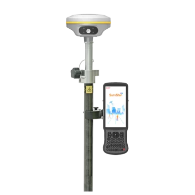
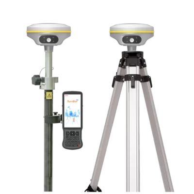
The South Galaxy G7Q is a miniaturized RTK GNSS receiver made for professional fieldwork in surveying, construction layout, civil engineering, GIS mapping and infrastructure measurement. It combines a 1598-channel GNSS engine, multi-constellation satellite tracking, 60° IMU tilt compensation, built-in UHF radio, WiFi, Bluetooth, NFC and 4G connectivity in a compact receiver weighing 907 g with the battery included.
For daily field crews, the G7Q is designed to keep RTK work practical. It is light enough to use comfortably on a pole during long survey days, but still includes the communication, positioning and durability features needed for centimetre-level point collection, stake-out and mapping. It is suitable for topographic surveys, construction control, road and utility work, cadastral measurement, GIS asset collection and drone ground control point measurement.
Compact receiver for everyday RTK surveying
The Galaxy G7Q is built around a compact 135 mm × 135 mm × 83 mm housing with a magnesium-aluminium alloy shell. This makes it a good fit for surveyors and construction teams who want a capable GNSS rover without carrying unnecessary weight. The receiver is easy to handle on busy sites, open field projects and mobile mapping jobs where equipment has to move quickly between points.
Single-button operation and four LED indicators make it simple to check the receiver status in the field. Operators can quickly see key information such as satellite tracking, data link, Bluetooth and power status without spending time inside menus during basic daily operation.
1598-channel GNSS performance for reliable positioning
The South Galaxy G7Q uses a 1598-channel GNSS board and tracks GPS, GLONASS, BeiDou, Galileo, QZSS and SBAS signals. In real fieldwork, strong satellite availability helps maintain a usable RTK solution when working near buildings, machinery, roads, tree lines or other areas where the sky view is not always ideal.
For RTK surveying, the receiver is specified at 8 mm + 1 ppm horizontal accuracy and 15 mm + 1 ppm vertical accuracy. This makes it suitable for common centimetre-level tasks such as construction layout, stake-out, topographic surveys, boundary work, volume surveys, site control and engineering measurements when used with the correct correction source and field setup.
60° IMU tilt compensation for faster point measurement
The built-in IMU tilt compensation helps users measure and stake out points without keeping the pole perfectly vertical for every observation. This is especially useful when measuring close to walls, fences, trenches, slopes, parked machinery, stockpiles or other obstacles where levelling the pole is difficult or slow.
The IMU corrects the measured position to the pole tip and supports tilt angles up to 60°. For surveyors, construction workers and GIS field teams, this can make point collection faster and more natural. The calibration-free IMU design also helps keep the workflow simple, especially for teams that need reliable results without complicated setup steps.
Integrated UHF radio for base and rover workflows
The G7Q includes a built-in 2 W UHF radio for transmitting and receiving correction data. It supports the 410 MHz to 470 MHz frequency range and communication protocols including Farlink, Trimtalk450s, SOUTH, HUACE, Hi-target and Satel. With Farlink protocol, the receiver has a typical working range of 8 km, depending on terrain, antenna setup, radio conditions and local interference.
This makes the Galaxy G7Q useful for both rover-only and base-rover RTK workflows. A local base-rover setup is helpful on construction sites, remote projects and areas where mobile internet coverage or RTK network access is not reliable. When an RTK network is available, the receiver can also be used in NTRIP-based network RTK workflows through compatible field software and correction services.
4G WiFi Bluetooth and NFC connectivity
The South Galaxy G7Q supports several communication options to fit different field setups. Bluetooth can be used to connect the receiver with a controller or tablet, while WiFi gives access to receiver management and web interface functions. NFC supports quick close-range pairing with compatible controllers, helping crews connect equipment with less setup time.
The receiver also supports cellular network datalink functionality for network correction workflows. For teams that move between job sites, this communication flexibility makes the G7Q suitable for simple rover operation, local base-rover work and network RTK setups.
Long battery life for full working days
The built-in 7.2 V 6800 mAh rechargeable Li-ion battery is specified for up to 15 hours of use in rover Bluetooth mode. This gives surveyors, engineers and GIS users enough runtime for long field sessions without constantly planning around charging breaks.
The universal Type-C interface supports charging and can also be used for data transfer and access to internal functions. Power bank support is useful for longer projects, remote sites or teams that need to keep the receiver running through extended working days.
Designed for outdoor site conditions
The Galaxy G7Q is IP67-rated for water and dust protection, making it suitable for outdoor GNSS work in wet, dusty and demanding field environments. It is designed for the type of conditions often found on construction sites, road projects, open land surveys and infrastructure jobs, including rain, mud, dust, transport vibration and regular field handling.
The receiver also includes 4 GB internal storage as standard, expandable storage support, USB data transfer, FTP/HTTP data download, electronic bubble support, voice guidance and web interface management. These features help field users manage data, check receiver status and configure working modes more easily during daily use.
Who is the South Galaxy G7Q made for?
The South Galaxy G7Q is a strong choice for professionals who need a compact RTK GNSS receiver with tilt measurement and flexible communication. It fits surveyors collecting topographic data, construction workers setting out points, civil engineers checking site positions, GIS teams mapping assets and drone pilots measuring ground control points.
It is especially useful for users who want a practical GNSS receiver that can work with both UHF radio and network RTK workflows. The combination of 60° IMU tilt, 1598-channel tracking, integrated radio, 4G capability and long battery life makes it a versatile tool for daily positioning tasks.
Typical applications
- Land surveying and topographic measurement
- Construction layout and stake-out
- Cadastral and boundary surveys
- Road, utility and infrastructure projects
- GIS asset mapping and data collection
- Drone ground control point measurement
- Base and rover RTK workflows
Buying the South Galaxy G7Q from Global GPS Systems
Global GPS Systems supplies professional GNSS and surveying equipment to customers worldwide from the Netherlands. When buying the South Galaxy G7Q, customers can get advice on the right configuration for their work, including rover setups, base-rover kits, controllers, poles, field software and RTK correction workflows.
For surveyors, engineers, construction teams and GIS users comparing compact RTK GNSS receivers, the South Galaxy G7Q offers a practical balance of accuracy, tilt compensation, communication options and field-ready durability.
Datasheets & Manuals
Datasheets and manuals
Datasheet
Specifications
South Galaxy G7Q RTK GNSS Receiver Specifications
Product Overview
| Product Name | South Galaxy G7Q |
|---|---|
| Product Type | Miniaturized RTK GNSS receiver |
| Receiver Model | G7Q |
| Primary Use | Professional land surveying, construction layout, civil engineering, mapping, GIS fieldwork, topographic surveys, cadastral work, stake-out and RTK point collection |
| Main Features | 1598-channel multi-constellation GNSS tracking, RTK positioning, 60° IMU tilt compensation, built-in UHF radio, Bluetooth, WiFi, NFC, Type-C connectivity, internal storage and IP67-rated housing |
GNSS Features
| GNSS Channels | 1598 channels |
|---|---|
| GPS Signals | L1, L1C, L2C, L2P, L5 |
| GLONASS Signals | L1C/A, L1P, L2C/A, L2P, L3 |
| BeiDou / BDS Signals | BDS-2: B1I, B2I, B3I; BDS-3: B1I, B3I, B1C, B2a, B2b |
| Galileo Signals | E1, E5A, E5B, E6C, AltBOC |
| SBAS Support | WAAS, MSAS, EGNOS, GAGAN |
| IRNSS Support | L5 |
| QZSS Signals | L1, L2C, L5 |
| MSS L-Band | BDS-PPP / Galileo HAS |
| Positioning Output Rate | 1 Hz to 20 Hz |
| Initialization Time | < 10 seconds |
| Initialization Reliability | > 99.99% |
Positioning Precision
| Code Differential GNSS Accuracy | Horizontal: 0.25 m + 1 ppm RMS; Vertical: 0.50 m + 1 ppm RMS |
|---|---|
| Static Accuracy – Long Observations | Horizontal: 2.5 mm + 0.1 ppm RMS; Vertical: 3 mm + 0.4 ppm RMS |
| Static Accuracy | Horizontal: 2.5 mm + 0.5 ppm RMS; Vertical: 3.5 mm + 0.5 ppm RMS |
| Rapid Static Accuracy | Horizontal: 2.5 mm + 0.5 ppm RMS; Vertical: 5 mm + 0.5 ppm RMS |
| PPK Accuracy | Horizontal: 3 mm + 1 ppm RMS; Vertical: 5 mm + 1 ppm RMS |
| RTK UHF Accuracy | Horizontal: 8 mm + 1 ppm RMS; Vertical: 15 mm + 1 ppm RMS |
| RTK NTRIP Accuracy | Horizontal: 8 mm + 0.5 ppm RMS; Vertical: 15 mm + 0.5 ppm RMS |
| RTK Initialization Time | 2 to 8 seconds |
| IMU Tilt Compensation Accuracy | Additional horizontal pole-tip uncertainty typically less than 10 mm + 0.7 mm/° tilt down to 30° |
| IMU Tilt Angle Range | 0° to 60° |
IMU and Sensors
| IMU Module | Built-in IMU module |
|---|---|
| IMU Calibration | Calibration-free |
| Magnetic Interference Resistance | IMU specified as immune to magnetic interference |
| Tilt Measurement Use | Corrects measured coordinates to the pole tip for faster point measurement and stake-out without strict receiver leveling |
| Electronic Bubble | Controller software can display the electronic bubble and check carbon pole leveling status in real time |
| Thermometer | Built-in thermometer sensor |
| Temperature Control | Intelligent temperature control technology for monitoring and adjusting receiver temperature |
Communications
| Internal UHF Radio | Built-in 2 W radio, receive and transmit |
|---|---|
| Radio Functions | Radio router and radio repeater support |
| UHF Frequency Range | 410 MHz to 470 MHz |
| Radio Protocols | Farlink, Trimtalk450s, SOUTH, HUACE, Hi-target, Satel |
| Radio Communication Range | Typically 8 km with Farlink protocol |
| Cellular Network | Supports cellular network datalink |
| Network RTK Support | VRS, FKP, MAC and full NTRIP protocol support |
| Bluetooth | Bluetooth 3.0/4.1 standard; Bluetooth 2.1 + EDR |
| NFC Communication | Quick Bluetooth pairing by simple touch; close-range automatic pairing between receiver and compatible controller |
| WiFi Modem | 802.11 b/g standard |
| WiFi Hotspot | Receiver broadcasts its hotspot for web UI access with mobile terminals |
| WiFi Datalink | Receiver can transmit and receive correction data stream via WiFi datalink |
Ports and Interfaces
| External Power / Serial Port | 5-pin LEMO external power port + RS232 |
|---|---|
| USB / Type-C Interface | Type-C interface for charging, OTG, data transfer to PC or phone and Ethernet |
| UHF Antenna Interface | 1 UHF antenna interface |
| Web Interface Access | Internal web interface management via WiFi or USB connection |
| Power Bank Support | Supports power supply from a power bank through the universal Type-C interface |
| Charging Interface | Universal Type-C interface; supports charging of the built-in battery with compatible PD rapid charger |
Data Storage and Transmission
| Internal Storage | 4 GB SSD internal storage as standard |
|---|---|
| Storage Expansion | Expandable up to 64 GB |
| Automatic Cycle Storage | Oldest data files are removed automatically when memory is insufficient |
| External Storage | Supports external USB storage |
| Sample Interval | Customizable sample interval up to 20 Hz |
| USB Data Transfer | Plug-and-play USB data transmission |
| Remote Data Download | Supports FTP/HTTP data download |
| Static Data Formats | STH, RINEX 2.01, RINEX 3.02 and related formats |
| Differential Data Formats | RTCM 2.1, RTCM 2.3, RTCM 3.0, RTCM 3.1, RTCM 3.2 |
| GPS Output Data Formats | NMEA 0183, PJK plane coordinate, binary code |
| Network Model Support | VRS, FKP, MAC and full NTRIP protocol support |
Hardware Performance
| Dimensions | 135 mm (W) × 135 mm (L) × 83 mm (H) |
|---|---|
| Weight | 907 g, battery included |
| Housing Material | Magnesium aluminium alloy shell |
| Operating Temperature | -25°C to +65°C |
| Storage Temperature | -40°C to +80°C |
| Humidity | 100% non-condensing |
| Waterproof / Dustproof Rating | IP67 |
| Water Protection | Protected from long-time immersion to a depth of 1 m |
| Dust Protection | Fully protected against blowing dust |
| Shock / Vibration | Withstands 2 m pole drop onto cement ground naturally |
| Power Supply | 6 V to 28 V DC with overvoltage protection |
| Battery | Built-in 7.2 V, 6800 mAh rechargeable Li-ion battery |
| Battery Life | 15 hours in rover Bluetooth mode |
User Interface and Software
| Operating System | Linux |
|---|---|
| Buttons | Single button |
| Indicators | 4 LED indicators: satellite, datalink, Bluetooth and power |
| Body Display Panel | Translucent high-strength panel with four color indicator lights |
| Web Interaction | Internal web interface management via WiFi or USB connection for monitoring receiver status and changing configurations |
| Voice Guidance | Status and operation voice guidance |
| Supported Voice Languages | Chinese, English, Korean, Spanish, Portuguese, Russian and Turkish |
| Secondary Development | Provides secondary development package and opens OpenSIC observation data format and interaction interface definition |
| Cloud Service | Online services including remote management, firmware update and online registration |
Supported Workflows and Applications
| RTK Rover Use | Supported |
|---|---|
| Base-Rover Use | Supported via integrated UHF radio and compatible correction workflows |
| Network RTK Use | Supported with NTRIP-compatible network RTK workflows |
| Static GNSS Observation | Supported |
| PPK Workflows | Supported |
| Stake-Out | Supported |
| Topographic Surveying | Supported |
| Construction Layout | Supported |
| GIS Data Collection | Supported |
| Cadastral and Engineering Surveying | Supported |
| Drone Ground Control Point Measurement | Supported |
Specifications and package contents may vary by configuration, region or manufacturer update. Always check the current configuration before ordering.
FAQ
South Galaxy G7Q RTK GNSS Receiver FAQ
Product Overview
What is the South Galaxy G7Q RTK GNSS Receiver?
The South Galaxy G7Q is a compact professional RTK GNSS receiver for accurate field positioning. It is designed for land surveying, construction layout, civil engineering, mapping, GIS data collection, infrastructure measurement and RTK point collection.
Who is the South Galaxy G7Q designed for?
The G7Q is designed for surveyors, construction teams, civil engineers, GIS professionals, mapping specialists, infrastructure crews and drone operators who need reliable centimetre-level positioning in the field.
What type of work can the South Galaxy G7Q be used for?
The receiver can be used for topographic surveys, stake-out, cadastral work, construction layout, road and utility surveys, GIS asset mapping, engineering measurements, static observations and drone ground control point measurement.
Is the South Galaxy G7Q suitable as a rover receiver?
Yes. The South Galaxy G7Q is well suited for rover use in RTK workflows. It can work with a local base station through UHF radio or with compatible network RTK correction services such as NTRIP.
What makes the G7Q different from a basic GPS receiver?
The G7Q is a professional RTK GNSS receiver with 1598 channels, multi-constellation tracking, 60° IMU tilt compensation, integrated UHF radio, 4G, WiFi, Bluetooth, NFC, long battery life and an IP67-rated housing for demanding field use.
Accuracy and GNSS Performance
How accurate is the South Galaxy G7Q?
In RTK mode, the South Galaxy G7Q is specified at 8 mm + 1 ppm horizontal accuracy and 15 mm + 1 ppm vertical accuracy. Static accuracy is specified at 2.5 mm + 0.5 ppm horizontal and 5 mm + 0.5 ppm vertical.
How many GNSS channels does the G7Q have?
The South Galaxy G7Q has 1598 GNSS channels. This allows the receiver to track multiple satellite constellations and signals for strong positioning performance in professional survey environments.
Which satellite constellations does the South Galaxy G7Q support?
The G7Q supports GPS, GLONASS, BeiDou, Galileo, QZSS and SBAS. This broad constellation support helps improve satellite availability during surveying, mapping and construction work.
Can the South Galaxy G7Q deliver centimetre-level positioning?
Yes. When used with suitable RTK corrections, a proper field setup and good GNSS conditions, the South Galaxy G7Q is designed to deliver centimetre-level positioning for professional surveying and layout work.
Does the South Galaxy G7Q support static GNSS observations?
Yes. The G7Q supports static GNSS observation workflows in addition to RTK rover and base-rover use. This makes it suitable for projects where static measurement is required by the survey method or project specification.
IMU Tilt Compensation and Field Workflow
Does the South Galaxy G7Q have IMU tilt compensation?
Yes. The South Galaxy G7Q includes a built-in IMU module with tilt compensation from 0° to 60°. This helps the receiver correct measurements to the pole tip when the pole is tilted.
What does 60° IMU tilt compensation do?
The 60° IMU tilt function allows users to measure or stake out points without keeping the survey pole perfectly vertical at every point. This can make fieldwork faster and easier in difficult measuring locations.
Does the G7Q IMU need calibration?
The South Galaxy G7Q uses a calibration-free IMU tilt system. This helps field crews start measuring quickly without a separate IMU calibration routine before work.
Where is tilt compensation most useful?
Tilt compensation is useful near walls, fences, buildings, road edges, trenches, slopes, vegetation, parked machinery and other locations where it is difficult to keep the pole perfectly level.
Can IMU tilt compensation improve productivity?
Yes. By reducing the need to carefully level the pole for every point, IMU tilt compensation can speed up RTK point collection, stake-out and daily survey work.
Connectivity, Battery and Durability
Does the South Galaxy G7Q have a built-in UHF radio?
Yes. The G7Q includes a built-in 2 W UHF radio for local RTK correction workflows. It supports Farlink and other common radio protocols for base-rover operation.
What is the typical UHF radio range of the G7Q?
With Farlink protocol, the South Galaxy G7Q has a typical working radio range of up to 8 km. Actual range depends on terrain, antenna setup, radio conditions, interference and local regulations.
Can the South Galaxy G7Q be used with NTRIP correction services?
Yes. The G7Q supports network RTK workflows, including NTRIP correction services, when used with compatible field software, internet access and a suitable correction subscription or provider.
What connectivity options does the G7Q support?
The South Galaxy G7Q supports UHF radio, 4G internet functionality, WiFi, Bluetooth and NFC. These options make it suitable for both local base-rover RTK and network RTK workflows.
How long does the South Galaxy G7Q battery last?
The built-in 6800 mAh battery is specified for up to 15 hours of operation in rover Bluetooth mode, helping support long field days without frequent charging.
Can the G7Q be charged with USB Type-C?
Yes. The South Galaxy G7Q uses a USB Type-C interface for charging. It can also support power from a power bank depending on the field setup.
Is the South Galaxy G7Q waterproof and dustproof?
Yes. The G7Q has an IP67-rated housing, making it protected against dust and water ingress for outdoor surveying, construction and mapping work in demanding field conditions.
Reviews (0)
Only logged in customers who have purchased this product may leave a review.


Reviews
There are no reviews yet