
 GPS & GNSS
 Lidar scanning
 Total Station


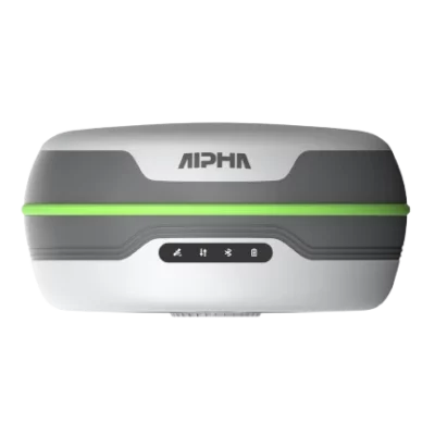


Alpha 5W GNSS RTK Receiver with 5W Radio and IMU Tilt
This product is Available
Contact our experts for the best possible price and configuration.
The Alpha 5W GNSS RTK is a compact long-range RTK receiver built for surveyors, construction teams, GIS users and mapping professionals who need reliable centimetre-level positioning in the field. With a built-in 5W UHF radio, onboard 4G, full GNSS signal tracking and calibration-free IMU tilt measurement, it can work as a rover or base station for everyday surveying, stakeout and site measurement tasks.
Alpha 5W GNSS RTK Highlights
| GNSS Channels | 1408 channels |
|---|---|
| Built-in Radio | 5W Rx and Tx UHF radio, 410–470 MHz |
| IMU Tilt | Calibration-free tilt measurement, up to 60° for ground points |
| Satellite Support | GPS, GLONASS, Galileo, BeiDou, QZSS and SBAS |
| Field Protection | IP67 water and dust protection with shock-resistant design |
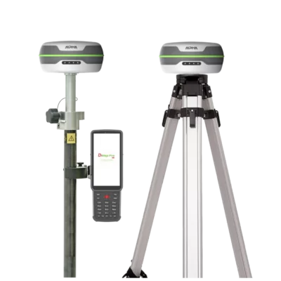
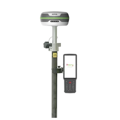
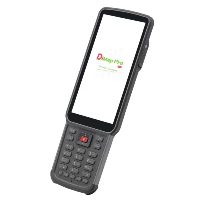
Valued customers:










Find RTK Networks
Search NTRIP providers and connect to reliable RTK correction services.
Description
Alpha 5W GNSS RTK Receiver for Long Range Survey Work
The Alpha 5W GNSS RTK receiver is designed for field teams that need a practical, powerful and portable RTK solution. It combines a built-in 5W UHF radio, onboard 4G connectivity, multi-constellation GNSS tracking and IMU tilt compensation in a compact 800 g receiver. This makes it suitable for surveyors, construction workers, engineers, GIS teams, drone mapping crews and other professionals who need accurate GNSS positioning without carrying unnecessary extra equipment.
For day-to-day site work, the main advantage of the Alpha 5W is its communication flexibility. The integrated 5W radio can be used for rover and base workflows, helping teams work in areas where mobile internet correction services are not always the best option. The receiver supports the 410–470 MHz UHF band and is compatible with common RTK radio protocols, making it easier to fit into existing GNSS setups.
Built-in 5W UHF radio for rover and base use
The Alpha 5W is built around long-range RTK communication. Its internal 5W radio can transmit and receive correction data, so the receiver can be used as a base station or as a rover depending on the job. In open conditions, this gives survey teams more freedom to cover larger sites, while in urban or partially obstructed areas it helps maintain a stable correction link where a lower-powered radio may struggle.
This is useful for construction layout, boundary work, topographic surveys, agriculture mapping, infrastructure projects and remote fieldwork. Instead of relying only on mobile network coverage, the Alpha 5W gives the crew a direct radio option for local RTK corrections.
IMU tilt compensation for faster point measurement
The Alpha 5W includes calibration-free inertial tilt measurement. In practical terms, this allows the pole to be tilted while measuring points, reducing the need to keep the receiver perfectly level for every observation. That can save time when working close to walls, fences, road edges, trenches, vegetation, parked vehicles or other obstacles.
The receiver supports 60° tilt measurement for ground points and can support horizontal and aerial point measurement workflows under suitable satellite conditions. For survey and construction crews, this means fewer missed points and less time spent repositioning the pole in difficult places.
Full GNSS signal tracking for reliable field positioning
With 1408 channels and support for GPS, GLONASS, Galileo, BeiDou, QZSS and SBAS signals, the Alpha 5W is made for modern multi-constellation GNSS work. Tracking more satellite systems can help improve availability and stability, especially on sites where sky view changes throughout the day.
The receiver is suitable for RTK surveying, static observation and NTRIP correction workflows. It also supports onboard 4G, allowing teams to connect to correction services when mobile network coverage is available.
Long battery performance for full working days
The Alpha 5W is made for long field sessions. The receiver supports extended working times across different modes, including NTRIP rover, NTRIP base, radio receive, radio transmit and static work. It also supports power bank power supply, which is useful for long survey days, remote jobs or projects where charging opportunities are limited.
For field crews, this reduces downtime and helps keep work moving across a full shift. Whether the job involves collecting topo points, staking out a construction design or setting up a temporary base, the Alpha 5W is built to stay in use for demanding outdoor work.
DiMap field software for surveying and stakeout
The Alpha 5W works with DiMap field software, which includes tools for measurement, stakeout, CAD drawing use and reporting. This is useful for crews that need to move between design files, point collection and stakeout tasks without making the workflow overly complicated.
For construction and surveying teams, practical software matters as much as receiver specifications. DiMap is designed to support common RTK field tasks such as point measurement, line work, stakeout and data export, helping crews complete jobs more efficiently on site.
Compact receiver built for outdoor conditions
The Alpha 5W measures 138 mm × 68 mm and weighs around 800 g, making it easy to use on a survey pole for long periods. The IP67-rated housing helps protect against dust and water during outdoor work, while the shock-resistant design is suitable for normal field conditions.
Type-C charging and data transfer, Bluetooth connectivity, status indicator lights and built-in network communication make the receiver straightforward to operate in the field. It is a practical choice for teams that want a powerful RTK receiver without adding unnecessary complexity to their setup.
Who is the Alpha 5W GNSS RTK for?
The Alpha 5W is a strong fit for professionals who need RTK accuracy across larger or more demanding sites. Surveyors can use it for topographic work, control points, cadastral support and stakeout. Construction teams can use it for layout, earthworks checks and as-built measurements. GIS users can collect accurate asset data, while drone mapping teams can use GNSS control workflows to support aerial survey projects.
It is especially useful for users who want the flexibility of both radio RTK and 4G/NTRIP corrections. That makes it suitable for mixed environments, from open rural sites to construction zones and infrastructure projects where working conditions can change quickly.
Buying the Alpha 5W from Global GPS Systems
Global GPS Systems supplies the Alpha 5W GNSS RTK receiver with support for professional GNSS users worldwide. Our team can help match the receiver with the right controller, software, pole, correction service and rover or base configuration for your workflow. This is important for buyers who want more than a receiver alone and need a complete setup that works reliably in the field.
For surveyors, construction professionals, GIS teams and mapping crews comparing RTK GNSS equipment, the Alpha 5W offers a useful balance of long-range radio communication, IMU tilt measurement, multi-constellation tracking and rugged portability.
Datasheets & Manuals
Datasheets and manuals
Datasheet
Specifications
Alpha 5W GNSS RTK Specifications
Product Overview
| Product Name | Alpha 5W GNSS RTK |
|---|---|
| Product Type | Multi-constellation GNSS RTK receiver |
| Primary Use | RTK surveying, mapping, construction layout, land measurement, infrastructure inspection, mining and geospatial fieldwork |
| Operating Roles | Rover or base station |
| GNSS Channels | 1408 |
| Built-in Radio | 5 W Rx/Tx UHF radio |
| Tilt Compensation | Calibration-free inertial tilt measurement |
| PPP Support | Supported; centimeter-level single-point positioning after approximately 10 minutes convergence |
| Field Software | DiMap field software support |
GNSS Signal Tracking
| GPS | L1C/A, L1C, L2C, L2P, L5 |
|---|---|
| BeiDou / BDS | B1I, B2I, B3I, B1C, B2a, B2b, ACEBOC |
| GLONASS | G1, G2, G3 |
| Galileo | E1, E5a, E5b, ALTBOC, E6 |
| QZSS | L1C/A, L1C, L2C, L5 |
| SBAS | L1, L5 |
Positioning Accuracy
| High Precision Static Accuracy – Horizontal | ±(2.5 + 0.5 × 10⁻⁶D) mm |
|---|---|
| High Precision Static Accuracy – Vertical | ±(5 + 0.5 × 10⁻⁶D) mm |
| RTK Accuracy – Horizontal | ±(8 + 1 × 10⁻⁶D) mm |
| RTK Accuracy – Vertical | ±(15 + 1 × 10⁻⁶D) mm |
| PPP Convergence | Approximately 10 minutes to centimeter-level single-point positioning |
Tilt Compensation
| Tilt Technology | Calibration-free inertial navigation with positioning and magnetometer data |
|---|---|
| Tilt Accuracy | ±(8 + 0.3TILT) mm |
| Tilt Angle Range | 0° to 120° |
| 60° Tilt Performance | 2 cm accuracy at 60° tilt |
| Horizontal Point Measurement | Supports 90° horizontal point measurement |
| Aerial Point Measurement | Supports short-duration 120° aerial point measurement under good satellite conditions |
| Tilt Initialization | No formal initialization required; enters inertial navigation mode after walking a few steps |
| Update Rate | 100 Hz |
Radio and Data Link
| Internal Radio Power | 5 W |
|---|---|
| Radio Mode | 5 W Rx & Tx |
| Radio Frequency Range | 410–470 MHz |
| Maximum Coverage Range | Up to 8 km in ideal environments |
| Urban Coverage Range | Up to 5 km in urban environments |
| External Radio Compatibility | Compatible with 35 W external radio |
| Supported Radio Protocols | TRIMTALK 450S, TRIMMARK III, SOUTH 9600, SOUTH 19200, SATEL 9600, SATEL 19200, Transparent |
| Recommended Base Setup | Place base station in a relatively high and open area for best radio coverage |
System and Data
| Operating System | RTOS |
|---|---|
| Internal Storage / ROM | 8 GB |
| Data Record Format | DAT |
| Bluetooth | Bluetooth 5.2 BR/EDR + LE dual-mode Bluetooth |
Network Communication
| GSM Bands | B2, B3, B5, B8 |
|---|---|
| UMTS Bands | B1, B2, B4, B5, B6, B8, B19 |
| LTE-TDD Bands | B38, B39, B40, B41 |
| LTE-FDD Bands | B1, B2, B3, B4, B5, B7, B8, B12, B13, B18, B19, B20, B25, B26, B28 |
Power and Battery Life
| Mode | Working Time | Notes |
|---|---|---|
| NTRIP | 40 hours | Listed ultra-long battery life mode |
| NTRIP Base | 22 hours | Base operation via NTRIP |
| NTRIP Rover | 24 hours | Rover operation via NTRIP |
| Static | 32 hours | Static observation mode |
| Radio Receive | 18 hours | UHF receive operation |
| Radio Transmitter | 6.5 hours | UHF transmit operation |
| Input Voltage | 5–12 V QC2.0 |
|---|---|
| External Power Support | Supports power bank power supply |
| Receiver Working Time | 25 hours in NTRIP mode as listed in technical specification table |
| Rover Mode Working Time | Over 40 hours with smart power supply, as listed in product overview |
Ports and Indicators
| TNC Connector | For connecting built-in radio antenna |
|---|---|
| USB Type-C | For charging and data transmission |
| Indicator Lights | Satellite, datalink, Bluetooth, battery |
Physical Specifications
| Dimensions | 138 mm × 68 mm |
|---|---|
| Weight | 800 g |
| Receiver Design | Compact integrated GNSS receiver with built-in UHF radio |
Environmental Specifications
| Operating Temperature | -30°C to +70°C |
|---|---|
| Storage Temperature | -40°C to +80°C |
| Water and Dust Protection | IP67 |
| Shock Resistance | Resistant to 2 m pole fall at room temperature on hard floor; 1.2 m free-fall resistance |
| Humidity Resistance | 100% condensation resistant |
Alpha B55 Controller Specifications
| Software Platform | Android 11 |
|---|---|
| CPU | 8-core 2.0 GHz |
| Memory and Storage | 4 GB DDR4 + 64 GB |
| Network System | Nano SIM 4G |
| Screen | 5.5 inch, 720 × 1440 resolution |
| Bluetooth | BT 5.0 BLE |
| Battery | 3.7 V, 7700 mAh |
| Keyboard | Backlit nine-key keyboard |
| Weight | 335 g |
DiMap Field Software Features
| Survey Modules | Built-in professional survey modules |
|---|---|
| RTK Compatibility | Compatible with mainstream RTK workflows |
| Measurement Interface | Large-scale measurement and stakeout interface |
| Stakeout Records | Separate stakeout record management |
| Report Export | One-click export of stakeout reports |
| CAD Drawing Support | Recognizes mainstream CAD drawings and supports fast opening of large drawings |
| Drawing Editing | Drawing editing and stakeout tools supported |
| Data Filtering | Exported data can be directly filtered |
Recommended Applications
| Surveying and Mapping | Boundary work, topographic surveys, control work and field data collection |
|---|---|
| Construction Layout | Site layout, stakeout and infrastructure positioning |
| Agricultural Land Measurement | Land area measurement and field mapping |
| Infrastructure Inspection | Field positioning for inspection and asset documentation |
| Mining and Exploration | Positioning and mapping in open-field or rugged environments |
| Difficult Measurement Points | Covered places, dense jungle, underground-adjacent locations, dangerous points, building edges, hiding points, level points and aerial points |
Package / Included Items
| Item | Quantity | Notes |
|---|---|---|
| GNSS Receiver | 1 | Alpha 5W receiver |
| Charger for Receiver | 1 | Receiver charging accessory |
| Power Cable | 1 | Receiver power cable |
| UHF Antenna | 1 | For internal radio operation |
| Carrying Case | 1 | Transport and storage case |
| Controller | 1 | Alpha B55 controller listed in datasheet package |
| Controller Bracket | 1 | Mounting bracket for controller |
| Charger for Controller | 1 | Controller charging accessory |
| Power Cable | 1 | Controller or accessory power cable |
| GNSS Pole + Bag | 1 | Survey pole with carrying bag |
Specifications and package contents may vary by configuration, region or manufacturer update. Always check the current configuration before ordering.
FAQ
Alpha 5W GNSS RTK FAQ
Product Overview
What is the Alpha 5W GNSS RTK receiver?
The Alpha 5W is a professional GNSS RTK receiver designed for centimeter-level positioning in surveying, construction layout, mapping, GIS data collection and stakeout work. It can be used in rover or base workflows and is built around long-range RTK communication, multi-constellation satellite tracking and calibration-free tilt measurement.
Who is the Alpha 5W designed for?
The Alpha 5W is designed for land surveyors, construction teams, site engineers, GIS professionals, utility mapping teams, infrastructure contractors, agriculture users and drone mapping crews that need accurate field positioning.
What types of work can I do with the Alpha 5W?
You can use the Alpha 5W for topographic surveys, boundary work, construction layout, road work, utility mapping, terrain models, stakeout, earthworks, infrastructure projects and ground control points for drone mapping.
Can the Alpha 5W be used as both a rover and a base station?
Yes. The Alpha 5W is designed for both rover and base station operation. As a rover, it receives correction data for accurate measurements. As a base station, it can transmit correction data to a rover using its built-in radio or other supported correction workflows.
Is this product a complete rover set?
This product page is for the Alpha 5W GNSS RTK receiver. For a complete field setup, users typically also need a controller, field software, pole, bracket, charger, antenna and carrying case. Complete Alpha 5W Rover Set and Rover & Base Set options are available separately.
Accuracy, GNSS and RTK Performance
Does the Alpha 5W provide centimeter-level accuracy?
Yes. When used with suitable RTK corrections from a base station, RTK network or compatible correction service, the Alpha 5W is designed to deliver centimeter-level positioning for professional field measurements.
Which satellite constellations does the Alpha 5W support?
The Alpha 5W supports major GNSS constellations including GPS, GLONASS, Galileo and BeiDou. This multi-constellation tracking helps improve availability and performance in different regions and working conditions.
How many GNSS channels does the Alpha 5W have?
The Alpha 5W has 1408 GNSS channels, allowing it to track multiple satellite signals across supported constellations for stable RTK positioning.
Does the Alpha 5W support NTRIP correction services?
Yes. The Alpha 5W can be used in RTK workflows with correction data from an RTK network, NTRIP service or local base station, depending on the selected field setup and accessories.
Can the Alpha 5W work without an RTK network?
Yes. When used with a local base station, the Alpha 5W can operate independently from RTK networks or mobile internet. This is useful on remote sites, large private projects, rural areas or places with unreliable network coverage.
Does the Alpha 5W support PPP positioning?
Yes. The Alpha 5W supports PPP positioning. PPP can be useful for precise single-point positioning in areas where conventional base station or network correction coverage is limited.
Radio, Range and Connectivity
What is special about the Alpha 5W built-in radio?
The Alpha 5W includes a built-in 5W UHF radio transceiver. This allows long-range communication between base and rover without needing a separate internal radio module, making it useful for large sites and remote RTK projects.
What radio range can the Alpha 5W achieve?
The built-in 5W radio can cover up to 8 km in ideal open conditions and around 5 km in urban environments. Actual range depends on terrain, obstacles, antenna setup, radio settings, local interference and the position of the base station.
Which UHF frequency range does the Alpha 5W support?
The Alpha 5W supports the 410–470 MHz UHF frequency band, making it compatible with many mainstream RTK radio workflows and field configurations.
Is the Alpha 5W compatible with mainstream RTK radio protocols?
Yes. The Alpha 5W is designed for compatibility with mainstream RTK radio protocols, which helps it integrate into different rover/base workflows and mixed equipment environments.
Can the Alpha 5W be used with an external radio?
Yes. The Alpha 5W is compatible with external radio workflows, including 35W external radio use where the project setup and local radio regulations allow it.
Where should I place the base station for the best radio range?
For best radio performance, place the base station in a high, open location with a clear line of sight where possible. Avoid placing the base behind buildings, dense vegetation, vehicles or terrain obstacles that can reduce radio range.
Field Use, IMU and Software
Does the Alpha 5W have tilt compensation?
Yes. The Alpha 5W includes IMU tilt compensation, allowing users to measure points without keeping the pole perfectly vertical. This is useful near walls, fences, trenches, buildings, vegetation and other hard-to-reach points.
Does the Alpha 5W IMU need calibration?
No. The Alpha 5W uses calibration-free inertial navigation. In normal use, you can walk a few steps to enter inertial navigation mode without a complex manual calibration process.
How accurate is the Alpha 5W tilt measurement?
The Alpha 5W is designed to provide accurate tilt measurement at high tilt angles, with manufacturer material describing 2 cm accuracy at 60 degrees. Real-world results depend on satellite conditions, correction quality, pole setup and field environment.
How long does the Alpha 5W battery last?
The Alpha 5W is designed for long field days, with more than 40 hours of operation in rover mode under suitable conditions. Battery life varies by operating mode, radio use, temperature, settings and connected accessories.
Can the Alpha 5W be powered by a power bank?
Yes. The Alpha 5W supports power bank power supply, which can help extend operation during long field projects or remote workdays.
What field software works with the Alpha 5W?
The Alpha 5W can be used with DiMap field software. DiMap includes survey and stakeout modules, CAD drawing support, stakeout record management, report export and field workflows for professional RTK users.
Is the Alpha 5W lightweight enough for daily field use?
Yes. The Alpha 5W receiver weighs about 800 g and has a compact body, making it suitable for daily use on a survey pole during long field sessions.
Reviews (0)
Only logged in customers who have purchased this product may leave a review.


 GPS & GNSS
 Total Stations
 Data collectors
 Software
 Correction services
 Machine control
 External radio
 Lasers & levellers
 Marine
 Accessories
Reviews
There are no reviews yet