
 GPS & GNSS
 Lidar scanning
 Total Station



FJD Trion V4E Pro RTK GNSS Rover Set with Laser and IMU Tilt
This product is available
Get the best price for your setup
Contact our experts for the best possible price and configuration.
The FJD Trion V4E Pro RTK GNSS Rover Set is a compact positioning solution for surveyors, construction crews, GIS teams, agricultural users and other professionals who need accurate coordinates without carrying a conventional full-size receiver.
Its integrated laser and IMU allow points to be measured when the receiver cannot be placed directly above them. This is useful beside walls, around obstacles, near trenches and in other locations where holding a survey pole perfectly vertical is difficult. With 1408 GNSS channels, multi-constellation tracking and centimetre-level RTK performance, the V4E Pro is designed for practical topographic surveys, construction measurements, utility mapping, boundary work and GIS data collection.
- Compact 320 g receiver for convenient handheld fieldwork
- Integrated laser measurement for difficult or inaccessible points
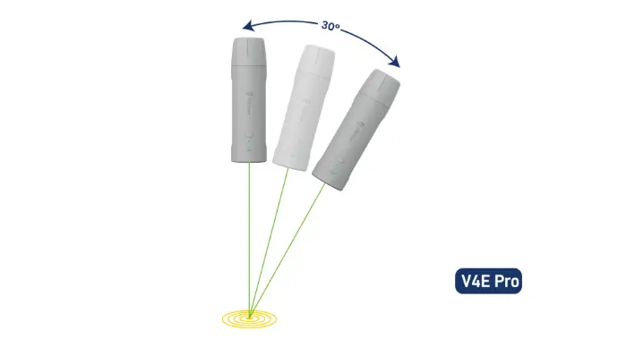
- Built-in IMU supporting tilt measurements up to 30°
- Tracks GPS, GLONASS, Galileo, BeiDou, QZSS and SBAS
- IP67 protection and at least 12 hours of operating time
FJD Trion V4E Pro Highlights
| RTK accuracy | Horizontal ≤0.8 cm + 1 ppm; vertical ≤1.5 cm + 1 ppm |
|---|---|
| Laser and IMU measurement | 3D error ≤3 cm at 3 m with a tilt angle up to 30° |
| GNSS tracking | 1408 channels across six satellite constellations |
| Weight | 320 g |
| Field protection | IP67 rated and designed to withstand a 1.2 m drop |
| Battery life | At least 12 hours with charging in 3 hours or less |

Valued customers:










Find RTK Networks
Search NTRIP providers and connect to reliable RTK correction services.
Description
Compact RTK GNSS Surveying with Laser Point Measurement
The FJD Trion V4E Pro combines an RTK GNSS receiver, laser measurement and IMU tilt compensation in a lightweight handheld unit. It is intended for professionals who need reliable positioning but do not always want to carry a larger rover and survey pole around the site. At only 320 g, it is easy to transport between jobs and comfortable to use for repeated point collection throughout the working day.
The V4E Pro can be used as a compact rover for topographic surveys, construction measurements, road surveying, utility work, public works, forestry, agriculture and GIS asset collection. Its practical advantage is the ability to collect a coordinate when the receiver cannot be positioned directly over the required point.
Measure Points That Are Difficult to Reach
Traditional GNSS measurements normally require the antenna to be centred above the point. On a real construction site, that is not always possible. The point may be beside a wall, below an overhang, near moving machinery, inside a trench or behind a physical obstruction.
The integrated laser provides a clear target for these situations. Together with the built-in IMU, it allows the operator to aim at the required point while holding the receiver at an angle. The V4E Pro supports laser-assisted measurements with a stated 3D error of no more than 3 cm at a distance of 3 m when the tilt angle is within 30°. This can reduce the need for awkward pole positioning and makes individual points quicker to capture.
This feature is especially useful for construction workers recording corners and offsets, surveyors measuring inaccessible details, GIS crews collecting assets beside roads or buildings, and agricultural users mapping boundaries and field features.
Centimetre-Level RTK Positioning
The receiver provides stated RTK accuracy of up to 0.8 cm plus 1 ppm horizontally and 1.5 cm plus 1 ppm vertically. In fieldwork, this means the V4E Pro can support jobs where repeatable, high-accuracy coordinates are required, provided that suitable satellite reception and RTK corrections are available.
RTK corrections can be received through an NTRIP service or a compatible base-station workflow. Support for RTCM 2.3, RTCM 3.x and CMR correction formats helps the receiver fit into a range of existing GNSS setups rather than limiting it to a single correction source.
Multi-Constellation Tracking for Everyday Site Conditions
The V4E Pro uses 1408 parallel channels and tracks GPS, BeiDou, GLONASS, Galileo, QZSS and SBAS signals. Access to several constellations gives the receiver more satellites to work with as conditions change across a site. This is valuable near buildings, tree lines, embankments and machinery, where parts of the sky may be obstructed.
No GNSS receiver can guarantee a fixed RTK solution in every environment, but broad signal tracking helps the operator maintain a more practical workflow in normal outdoor surveying conditions. The receiver has a stated RTK initialisation time of under five seconds when suitable corrections and satellite conditions are available.
Built for Mobile Crews and Long Field Days
Measuring 182 × 53 × 53 mm and weighing 320 g, the FJD Trion V4E Pro is considerably easier to carry than a conventional survey receiver. Its slim shape suits handheld use, while the integrated 1/4-inch thread allows it to be attached to a suitable pole or mounting accessory when a traditional setup is preferred.
The internal battery provides at least 12 hours of operation and can be charged in three hours or less through USB Type-C. It can also remain in operation while connected to a power bank, which is helpful during long shifts or remote work where returning to a vehicle or office is impractical.
An IP67 enclosure protects the receiver against dust and temporary water exposure. It is also designed to withstand a drop of up to 1.2 m. These features make it suitable for regular outdoor use on construction sites, farms, road projects and survey jobs, although normal care should still be taken with any precision measuring instrument.
Suitable Applications
For construction teams, the V4E Pro can support site measurements, as-built point collection, level checks and the recording of features that are difficult to occupy directly. Surveyors can use it for detail surveys, topographic work, boundaries and rapid point collection. GIS and utility crews can record poles, covers, valves, signs, trees and other assets with accurate coordinates.
Agricultural and forestry users can map field boundaries, paths, drainage features and areas of interest. The collected positioning data can also be used within compatible FJD workflows, including selected agricultural guidance and smart-device applications.
Drone operators may use accurately measured ground points, checkpoints or site features as part of a wider mapping workflow. The receiver itself is not a drone payload; it serves as a field positioning instrument for collecting the reference coordinates needed by the project.
Simple App-Based Operation
The receiver connects to a compatible mobile device through Bluetooth and is configured through the relevant FJD application. Operators can connect to an NTRIP account or compatible base station, monitor the positioning status and begin recording measurements once an RTK fixed solution has been obtained.
Indicator lights provide quick feedback about connection, positioning and charging status. This straightforward workflow makes the system accessible to less experienced construction and GIS users while still providing the positioning functions required by professional survey teams.
Who Should Choose the FJD Trion V4E Pro?
The V4E Pro is a strong option for buyers who value portability and need to measure points that are inconvenient to reach with a standard vertical survey pole. Its main strengths are the integrated laser, IMU tilt measurement, multi-constellation GNSS board and compact design.
A conventional pole-mounted rover may remain preferable for continuous high-volume surveying, precise height-controlled observations or projects that require a dedicated field controller. The V4E Pro is most useful where fast deployment, handheld operation and access to obstructed points are important parts of the job.
Buying and Support from Global GPS Systems
Global GPS Systems supplies the FJD Trion V4E Pro to construction professionals, surveyors, GIS teams, agricultural users and other customers who need accurate GNSS equipment. Our team can help confirm correction service compatibility, explain the intended field workflow and advise on suitable accessories before the system is put into use.
Choosing the correct RTK setup involves more than comparing accuracy figures. Available correction networks, local satellite visibility, data formats, software requirements and the type of points being measured all affect the final workflow. Practical product support helps ensure that the receiver is matched to the work it is expected to perform.
Datasheets & Manuals
Datasheets and manuals
Datasheets & manuals
Specifications
FJD Trion V4e Pro Rover Set Specifications
Product Overview
| Product Name | FJD Trion V4e Pro Rover Set |
|---|---|
| Receiver Type | Compact multi-frequency RTK GNSS rover receiver with integrated laser measurement and IMU tilt compensation |
| Model Version | V4e Pro |
| Positioning Method | GNSS, DGPS and network RTK positioning |
| Primary Functions | Centimetre-level coordinate measurement, RTK surveying, tilted-pole measurement and laser-assisted measurement of inaccessible points |
| Form Factor | Pocket-sized handheld or survey-pole-mounted receiver |
| Correction Workflow | NTRIP or compatible external correction source through the connected controller or mobile device |
| Built-in Cellular Modem | No |
| Built-in UHF Radio | No |
Applications and Users
| Land Surveying | Topographic surveys, point collection, control checks, boundary-related field measurements and coordinate collection |
|---|---|
| Construction and BIM | Site measurements, layout verification, as-built data collection and construction positioning workflows |
| Roads and Infrastructure | Road surveys, public works, infrastructure mapping and site inspection |
| Utilities and GIS | Asset mapping, utility location records and high-accuracy GIS data collection |
| Forestry and Agriculture | Boundary mapping, field measurement, forestry data collection and compatible precision-agriculture workflows |
| Drone Surveying | Ground control point and checkpoint coordinate measurement |
| Robotics | Coordinate collection for compatible robotic mowers, agricultural autosteering systems and customised robotic workflows |
GNSS Tracking
| GNSS Channels | 1408 parallel channels |
|---|---|
| Supported Constellations | GPS, BeiDou, GLONASS, Galileo, QZSS and SBAS |
| Number of Constellations | 6 |
| Supported Frequencies | Up to 19 GNSS frequencies/signals |
| BeiDou | B1I, B2I, B3I, B1C, B2a and B2b |
| GPS | L1 C/A, L2P and L5 |
| GLONASS | G1 and G2 |
| Galileo | E1, E5a, E5b and E6 |
| QZSS | L1, L2 and L5 |
| SBAS | L1 C/A |
| Firmware-Dependent Signals | BeiDou B2b and Galileo E6 require a supported firmware version |
Positioning Accuracy
| Positioning Mode | Horizontal Accuracy | Vertical Accuracy |
|---|---|---|
| Single-Point Positioning, RMS | ≤1.5 m | ≤2.5 m |
| DGPS, RMS | ≤0.4 m | ≤0.8 m |
| RTK, RMS | ≤0.8 cm + 1 ppm | ≤1.5 cm + 1 ppm |
Positioning Performance and Reliability
| Signal Reacquisition Time | ≤1 second |
|---|---|
| Cold-Start Time to First Fix | ≤30 seconds |
| Hot-Start Time to First Fix | ≤5 seconds |
| RTK Initialization Time | <5 seconds |
| Initialization Reliability | >99.9% |
| Measurement and Positioning Update Rates | 1 Hz, 2 Hz, 5 Hz, 10 Hz, 15 Hz and 20 Hz |
| Time Accuracy, RMS | 20 ns |
| Speed Accuracy, RMS | 0.03 m/s |
V4e Pro IMU Tilt Measurement
| IMU | Integrated inertial measurement unit |
|---|---|
| Maximum IMU Tilt Angle | Up to ±60° |
| Tilt Accuracy at Angles up to 30° | 3D error ≤2.5 cm |
| Tilt Accuracy at Angles up to 60° | 3D error ≤3.5 cm |
| Tilt Measurement Function | Allows coordinate collection without holding the receiver or survey pole perfectly vertical |
| Typical Tilt Applications | Measurement beside walls, fences, trenches, slopes, obstacles and other locations where vertical pole positioning is difficult |
V4e Pro Laser Measurement
| Integrated Laser | Yes, V4e Pro version |
|---|---|
| Laser Function | Laser point targeting for pole-free or inaccessible-point coordinate measurement |
| Laser-Assisted 3D Accuracy | 3D error ≤3 cm at a measurement distance of 3 m and a tilt angle of ≤30° |
| Laser Rangefinder Precision | ±3 mm at a distance of 10 m |
| Typical Laser Applications | Corners, walls, building edges, trenches, unsafe locations, obstructed points and other positions where direct receiver placement is impractical |
Correction Data and Output Formats
| Network RTK | NTRIP-supported correction workflow through a compatible internet-connected controller or mobile device |
|---|---|
| Differential Data Formats | RTCM 2.3, RTCM 3.x and CMR |
| Positioning Data Output | NMEA 0183 |
| Base Station Connection | Supported through a compatible base-station protocol and field configuration |
| Open Workflow Support | Supports integration and customisation for compatible third-party or specialised workflows |
Wireless Communication
| Bluetooth | Bluetooth 4.0 dual mode |
|---|---|
| Bluetooth Working Distance | Approximately 5 m |
| Wi-Fi | 2.4 GHz Wi-Fi |
| Wi-Fi Operating Mode | Base-station mode |
| Internal Mobile Data Connection | Not included; network corrections depend on the connected controller, phone or external data connection |
Power and Charging
| Charging Input | 5 V / 2 A |
|---|---|
| Power Consumption | ≤1.5 W |
| Charging and Data Interface | USB 2.0 Type-C |
| Charging Time | ≤3 hours |
| Battery Operating Time | ≥12 hours |
| Operation During Charging | Supported, including operation from a compatible external power bank |
| Charging Temperature | 0°C to 45°C |
Physical Characteristics
| Dimensions | 182 × 53 × 53 mm |
|---|---|
| Weight | 320 g |
| Housing Material | PC and ABS |
| Mounting Interface | Internal 1/4-inch threaded interface |
| Controls | On/off button |
| Status Indicators | Satellite/fix status indicator and charging indicator |
| Receiver Format | Handheld, bracket-mounted or survey-pole-mounted |
Status Indicators
| Flashing Blue Satellite Indicator | Receiver is operating but is not connected to the application |
|---|---|
| Flashing Red Satellite Indicator | Receiver is connected to the application but has not obtained a fixed RTK solution |
| Solid Green Satellite Indicator | Fixed positioning solution obtained |
| Red Charging Indicator | Battery is charging |
| Green Charging Indicator | Battery is fully charged |
Environmental Protection
| Ingress Protection | IP67 dust and water protection |
|---|---|
| Operating Temperature | -20°C to 60°C |
| Drop Resistance | Rated to withstand a drop of up to 1.2 m |
| Intended Environment | Outdoor field operation |
| Recommended GNSS Environment | Open outdoor location with suitable satellite visibility and access to correction data |
Software and Workflow Compatibility
| Survey Application | FJD Trion professional survey application or compatible supplied field software |
|---|---|
| Mobile Platform Support | Android and iOS application options are referenced by the manufacturer |
| Application Functions | Receiver connection, rover operation, data measurement, serial-port functions and receiver settings |
| Fixed-Solution Workflow | Fixed RTK solution after connecting to a suitable NTRIP account or compatible base station |
| FJD Ecosystem Compatibility | Collected GNSS data can be used with compatible FJD agricultural autosteering systems, robotic mowers and other supported smart devices |
Rover Set Package Contents
| Item | Quantity | Notes |
|---|---|---|
| FJD Trion V4e Pro Mini RTK Receiver | 1 | Pro receiver with integrated laser and IMU tilt measurement |
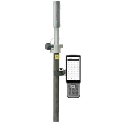
| Survey Pole | 1 | For conventional pole-mounted rover measurements |
| Controller or Phone Bracket | 1 | Mounts the field controller or compatible mobile device to the pole |
| Data Collector | 1 | Exact controller model and configuration may vary |
| USB-C Charging Cable | 1 | For receiver charging and compatible USB connection |
Operational Requirements and Notes
| RTK Correction Requirement | Centimetre-level RTK operation requires a compatible correction source and suitable GNSS reception conditions |
|---|---|
| Internet Requirement | An external internet connection is required when using NTRIP because the receiver does not contain an internal cellular modem |
| Recommended Charger | Use a compatible 5 V / 2 A charger and suitable USB-C cable |
| Long-Term Storage | Store in a cool, dry location with the battery at approximately 50%–80% charge and recharge periodically |
| Water Resistance Maintenance | Inspect the enclosure and charging interface regularly because wear or damage can reduce water resistance over time |
| Device Disassembly | Unauthorised disassembly is not recommended and may invalidate the manufacturer warranty |
Specifications and package contents may vary by configuration, region or manufacturer update. Always check the current configuration before ordering.
FAQ
FJD Trion V4E Pro FAQ
Product Use and Applications
What is the FJD Trion V4E Pro?
The FJD Trion V4E Pro is a compact professional RTK GNSS receiver with centimeter-level positioning, 30-degree IMU tilt compensation and an onboard laser rangefinder. It is designed for fast surveying, mapping and point collection in locations where a conventional full-size rover may be less convenient.
What is the difference between the FJD Trion V4E Standard and V4E Pro?
The Pro version adds the advanced IMU tilt and laser-assisted measurement functions intended for measuring tilted or difficult-to-reach points. Buyers should confirm that the selected set contains the V4E Pro configuration rather than the Standard receiver.
Who is the FJD Trion V4E Pro designed for?
It is designed for land surveyors, construction teams, civil engineers, GIS specialists, utility and public-works crews, road surveyors, forestry and agriculture users, drone-mapping operators and other professionals who require portable high-accuracy positioning.
Is the FJD Trion V4E Pro suitable for land surveying?
Yes. It can be used for topographic surveys, point collection, site measurements, control checks, as-built surveys and other RTK GNSS fieldwork. The suitability of any GNSS receiver for legal boundary work depends on local regulations, survey procedures and the required project accuracy.
Can the V4E Pro be used for construction, utilities and road surveying?
Yes. Typical applications include construction layout checks, site mapping, utility and asset mapping, infrastructure surveys, road measurements, public-works data collection and recording as-built positions.
Can drone operators use the V4E Pro for ground control points?
Yes. Drone surveyors can use it to measure ground control points and independent checkpoints for photogrammetry or LiDAR mapping projects, provided a suitable RTK correction source and survey workflow are used.
Accuracy, GNSS and RTK Corrections
What RTK accuracy can the FJD Trion V4E Pro achieve?
The stated RTK accuracy is horizontal ≤0.8 cm + 1 ppm and vertical ≤1.5 cm + 1 ppm under suitable operating conditions. Actual results depend on satellite visibility, correction quality, baseline distance, multipath, atmospheric conditions and correct field procedures.
Which satellite constellations does the V4E Pro support?
The receiver supports GPS, BeiDou, GLONASS, Galileo, QZSS and SBAS. Its 1,408 parallel channels allow it to track multiple signals and constellations for improved satellite availability.
How quickly does the V4E Pro initialize an RTK fixed solution?
The stated RTK initialization time is under five seconds in suitable conditions. A cold start is specified at 30 seconds or less and a hot start at five seconds or less. Initialization may take longer where satellite visibility or correction reception is poor.
Does the FJD Trion V4E Pro support NTRIP corrections?
Yes. The receiver supports NTRIP-based network RTK workflows through a compatible controller, mobile device or survey application with internet access. A valid correction-service account and suitable network coverage are normally required.
Which correction and data formats are supported?
The receiver supports RTCM 2.3, RTCM 3.x and CMR differential data, together with NMEA-0183 output. Compatibility with a particular correction provider or third-party application should be checked before deployment.
Does the V4E Pro have a built-in cellular modem or UHF radio?
No. The receiver does not include an internal cellular modem or built-in UHF radio. Network RTK corrections are normally supplied through the connected controller or mobile device, while other correction workflows require compatible external equipment.
IMU Tilt and Laser Measurement
What does the V4E Pro IMU tilt compensation do?
The built-in IMU allows points to be measured while the receiver or survey pole is tilted by up to 30 degrees. This reduces the need to level the pole precisely at every point and can improve efficiency on slopes, beside obstacles and in restricted spaces.
Must the survey pole be held perfectly vertical?
No. When the IMU tilt function is active and operating within its specified limits, the receiver can compensate for tilt up to 30 degrees. Normal survey checks should still be performed to verify the required accuracy.
What is the V4E Pro laser measurement function used for?
The laser function is intended for points where placing the receiver directly above the target is difficult, inefficient or unsafe. Examples include corners, walls, façades, edges, trenches, fenced areas and other obstructed locations.
How accurate is laser-assisted point measurement?
The specified laser tilt measurement performance is a three-dimensional point error of ≤3 cm at a 3 m measurement distance when the tilt angle is no greater than 30 degrees. Field accuracy can vary with the target surface, distance, instrument stability and GNSS conditions.
What does the ±3 mm at 10 m laser specification mean?
The ±3 mm at 10 m figure refers to the stated precision of the onboard laser rangefinder when measuring distance. It is different from the complete three-dimensional coordinate accuracy, which also depends on GNSS positioning, tilt calculation, targeting and field conditions.
Can the laser completely replace a survey pole?
No. The laser expands the number of points that can be measured without directly occupying them, but a survey pole remains useful for conventional RTK point collection, known-point checks, control work and measurements requiring standard survey procedures.
Connectivity, Battery and Field Durability
How does the FJD Trion V4E Pro connect to a controller?
The receiver supports dual-mode Bluetooth 4.0 for communication with a compatible controller or mobile device. The specified Bluetooth working distance is approximately 5 m, although actual range can vary with the device and field environment.
Does the V4E Pro support Android and iOS devices?
Manufacturer documentation references mobile application workflows for Android and iOS. The required functions, supported operating-system versions and compatibility with a particular controller should be confirmed before use.
How long does the V4E Pro battery last?
The stated battery operating time is at least 12 hours. Actual battery life may vary with temperature, communication activity, receiver settings, battery condition and the functions being used.
How is the receiver charged?
The V4E Pro uses a USB Type-C connection with a specified 5 V, 2 A charging input. Charging takes three hours or less under suitable conditions, and the receiver can continue operating while connected to a compatible external power bank.
Is the FJD Trion V4E Pro waterproof and suitable for fieldwork?
The receiver has an IP67 rating for resistance to dust and water exposure. It is designed for outdoor field use, but connectors should be protected and the receiver should be inspected for damage or wear that could reduce its environmental sealing.
Can the V4E Pro withstand drops and extreme temperatures?
The receiver has a stated 1.2 m drop-resistance rating and an operating-temperature range of −20°C to 60°C. Avoid unnecessary impacts, use suitable protection during transport and charge the unit only within its specified charging-temperature range.
Reviews (0)
Only logged in customers who have purchased this product may leave a review.


 GPS & GNSS
 Total Stations
 Data collectors
 Software
 Correction services
 Machine control
 External radio
 Lasers & levellers
 Marine
 Accessories
Reviews
There are no reviews yet