

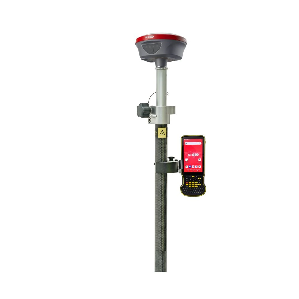


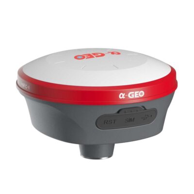

a-Geo L100 Pro Rover Set RTK GNSS Receiver with 120° IMU
This product is available
Get the best price for your setup
Contact our experts for the best possible price and configuration.
The a-Geo L100 Pro Rover Set is a compact RTK GNSS rover solution for surveyors, construction teams, engineers, GIS users and mapping professionals who need accurate positioning in daily fieldwork. With 1408 GNSS channels, full multi-constellation tracking, 120° IMU tilt compensation, built-in 4G and an internal UHF radio, it is built for topo surveys, stake-out, control work, construction layout and GIS data collection.
The receiver supports Network RTK, UHF RTK, Static and PPK workflows, giving field crews flexibility to work with an RTK correction network or a compatible local base setup. Its lightweight magnesium alloy body, IP67 protection and long rover battery life make it practical for long days on site.
a-Geo L100 Pro Rover Set Highlights
| GNSS Channels | 1408 tracking channels |
|---|---|
| Satellite Constellations | GPS, GLONASS, BeiDou, Galileo, QZSS, SBAS, IRNSS |
| IMU Tilt Compensation | Calibration-free IMU up to 120° |
| RTK Accuracy | 8 mm + 1 ppm horizontal, 15 mm + 1 ppm vertical |
| Connectivity | 4G, UHF radio, WiFi, Bluetooth 5.2 and WebUI |
| Field Durability | IP67, magnesium alloy body, 0.76 kg receiver weight |
| Battery Life | Up to 15 hours in rover mode |

Valued customers:


Find RTK Networks
Search NTRIP providers and connect to reliable RTK correction services.
Description
a-Geo L100 Pro Rover Set for RTK surveying and construction layout
The a-Geo L100 Pro Rover Set is a complete RTK GNSS rover package for professionals who need accurate, practical and flexible positioning in the field. It is designed for land surveyors, construction workers, civil engineers, GIS teams, drone mapping users and contractors who need reliable point measurement and stake-out without carrying a heavy or complicated system.
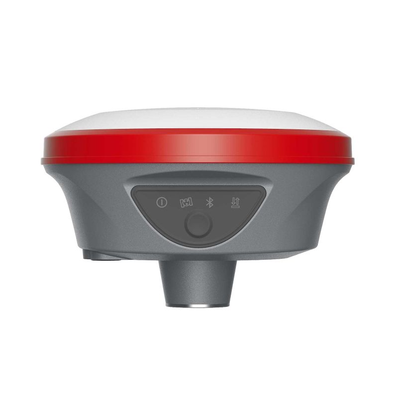
At the centre of the set is the a-Geo L100 Pro smart GNSS receiver. It combines a 1408-channel GNSS board, full multi-constellation satellite tracking, calibration-free IMU tilt compensation up to 120°, built-in 4G, internal UHF radio, WiFi, Bluetooth and WebUI configuration. This makes it suitable for daily RTK tasks such as topo surveys, control point checks, road staking, construction layout, as-built measurement and GIS data collection.
Flexible RTK workflows for different field conditions
The a-Geo L100 Pro can be used in several common GNSS workflows, including Network RTK, UHF RTK, Static and PPK. For users working with an RTK correction network, the built-in 4G modem supports NTRIP-style workflows where mobile coverage is available. For jobs where a local base setup is preferred, the integrated UHF radio allows the receiver to work in base-rover style correction workflows with compatible equipment.
This flexibility is useful for companies that work on different types of projects. A surveyor may use Network RTK for fast topo work in urban areas, while a construction crew may prefer a local base workflow on remote sites. The same rover can also be used for static or post-processing tasks when the project requires that approach.
Full multi-constellation GNSS tracking
The L100 Pro tracks GPS, GLONASS, BeiDou, Galileo, QZSS, SBAS and IRNSS signals. In practical fieldwork, this means the receiver can use a wide range of available satellites to help maintain a stable position solution. That can be especially useful when working near buildings, trees, slopes, site cabins, machinery or other obstacles that may block part of the sky.
For surveyors and construction users, more satellite availability can help reduce interruptions and improve confidence when collecting points or setting out positions. It does not remove the need for good survey practice, but it gives the operator a stronger GNSS foundation for real site conditions.
120° IMU tilt compensation for faster point collection
The integrated IMU tilt sensor helps users measure and stake out points without always holding the pole perfectly vertical. The a-Geo L100 Pro supports calibration-free tilt compensation up to 120° and is designed to be resistant to magnetic interference.
This is useful when the point is close to a wall, fence, trench, parked vehicle, kerb, vegetation or other obstruction. Instead of trying to force the pole into an awkward vertical position, the operator can tilt the pole and keep working. For construction layout, topo surveys and GIS collection, this can save time across a full working day and make fieldwork less frustrating.
Built-in 4G, UHF radio, WiFi, Bluetooth and WebUI
The a-Geo L100 Pro Rover Set is designed to connect in the ways field crews actually use. The built-in 4G modem supports correction data through mobile networks, while the internal UHF radio supports local radio correction workflows. The receiver also includes WiFi and Bluetooth 5.2 for connection, configuration and field operation.
The WebUI function allows users to access receiver settings, check status and manage data through a browser on a compatible device. This can be helpful when configuring the receiver, checking the connection or downloading data without relying on extra cables or specialist setup tools.
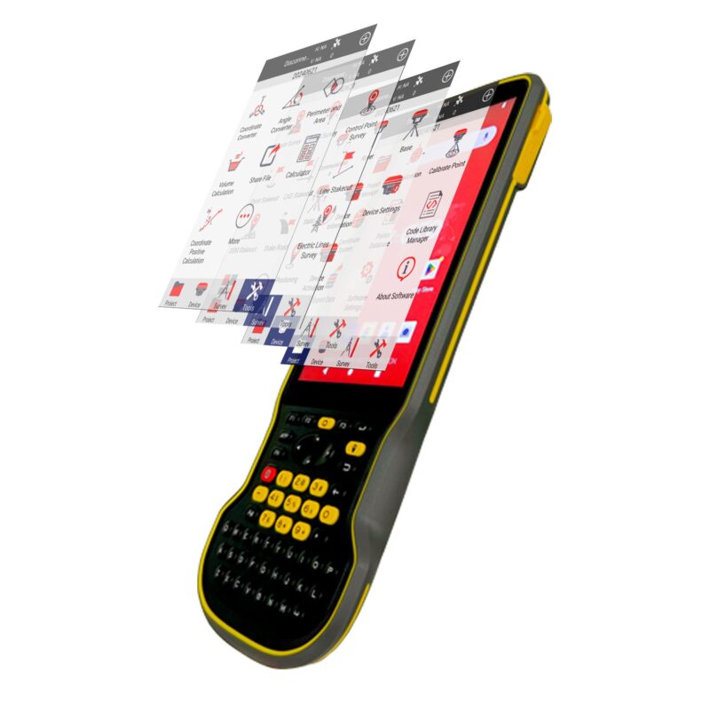
Practical software workflow for survey and GIS tasks
The rover set is supported by SurPro6.0 field software, giving users a practical workflow for common GNSS field tasks. It supports typical survey operations such as point measurement, control point work, point stake-out, line stake-out, CAD-based work, road design stake-out, GIS data collection and coordinate tools.
For construction users, this means the rover can be used for setting out points, checking positions and supporting layout work on site. For surveyors and GIS teams, it supports organised data collection and field measurement in the correct coordinate system. For drone mapping teams, it can be used for ground control and check point measurement when accurate field coordinates are needed.
Compact and rugged for everyday use
The a-Geo L100 Pro receiver has a magnesium alloy body and weighs 0.76 kg, making it easy to handle on a survey pole during long field days. Its IP67 rating protects it against dust and temporary water immersion, which is important when working in rain, mud, dust, construction environments or rough outdoor conditions.
The internal 7000 mAh lithium-ion battery provides up to 15 hours in rover mode, depending on the workflow and conditions. For most users, that means the receiver can support a full working day without constant battery changes. USB Type-C fast charging also makes charging more convenient between jobs.
Who is the a-Geo L100 Pro Rover Set for?
This rover set is a strong fit for professionals who need centimetre-level GNSS positioning in a compact and accessible package. It is suitable for land surveyors carrying out topo surveys and stake-out work, construction crews setting out points on site, engineers checking positions, GIS teams collecting accurate field data and drone pilots measuring ground control points.
It is also a practical option for buyers who want a capable RTK GNSS rover with IMU tilt, 4G and UHF connectivity, without moving into a more complex or expensive system than they need. The combination of full GNSS tracking, tilt compensation, multiple correction workflows and rugged design makes it a versatile choice for daily fieldwork.
Why buy from Global GPS Systems?
Global GPS Systems supplies GNSS equipment to surveyors, construction companies, engineers, GIS teams and mapping professionals worldwide. When you buy the a-Geo L100 Pro Rover Set from Global GPS Systems, you get support from specialists who understand RTK workflows, field software, correction services and practical site requirements.
Global GPS Systems ships worldwide from the Netherlands and can help with product selection, configuration questions, correction service advice and after-sales support. This gives buyers a clearer path from choosing the right rover set to getting it working in the field.
Datasheets & Manuals
Datasheets and manuals
Data sheets
Specifications
a-Geo L100 Pro Rover Set Specifications
Product Overview
| Product Type | RTK GNSS rover set |
|---|---|
| Main Receiver | a-Geo / AlphaGEO L100 Pro / L100 PRO+ |
| Typical Applications | RTK surveying, topographic surveys, construction layout, stake-out, control point measurement, road staking, GIS data collection, UAV ground control and PPK/static workflows |
| Supported Work Modes | Network RTK, UHF RTK, Static and PPK |
| Field Software Support | SurPro6.0 Android field software support |
GNSS Performance
| GNSS Channels | 1408 tracking channels |
|---|---|
| Supported Satellite Constellations | GPS, GLONASS, BeiDou, Galileo, QZSS, SBAS and IRNSS |
| GPS Signals | L1C/A, L1C, L2P(Y), L2C, L5 |
| GLONASS Signals | L1, L2, L3 |
| BeiDou Signals | B1I, B2I, B3I, B1C, B2a, B2b |
| Galileo Signals | E1, E5a, E5b, E6 |
| QZSS Signals | L1, L2, L5, L6 |
| SBAS Signals | L1, L5 |
| IRNSS Signals | L5 |
| Cold Start | < 60 seconds |
| Hot Start | < 15 seconds |
| Positioning Output Rate | 1 Hz to 20 Hz |
| Signal Reacquisition | < 1 second |
| RTK Initialization Time | < 10 seconds |
| RTK Initialization Reliability | > 99.99% |
| Time Accuracy | 20 ns |
Accuracy Specifications
| Code Differential Horizontal Accuracy | 0.25 m + 1 ppm RMS |
|---|---|
| Code Differential Vertical Accuracy | 0.50 m + 1 ppm RMS |
| SBAS Differential Positioning Accuracy | Typically < 5 m 3DRMS |
| Static GNSS Surveying Horizontal Accuracy | 2.5 mm + 0.5 ppm RMS |
| Static GNSS Surveying Vertical Accuracy | 5 mm + 0.5 ppm RMS |
| Single Baseline RTK Range | < 30 km |
| Single Baseline RTK Horizontal Accuracy | 8 mm + 1 ppm RMS |
| Single Baseline RTK Vertical Accuracy | 15 mm + 1 ppm RMS |
| Network RTK Horizontal Accuracy | 8 mm + 0.5 ppm RMS |
| Network RTK Vertical Accuracy | 15 mm + 0.5 ppm RMS |
Tilt, AR and Measurement Features
| IMU Tilt Compensation | Up to 120° |
|---|---|
| IMU Calibration | Calibration-free |
| Magnetic Interference Resistance | IMU specified as immune to magnetic interference |
| AR Support | Supported |
| Camera | 5 MP high-definition camera with large viewing angle |
| Live Scene Stakeout | Supported |
Receiver Hardware
| Body Material | Magnesium alloy |
|---|---|
| Dimensions | 131 x 64 mm |
| Weight | 0.76 kg |
| Operating Temperature | -40°C to +75°C |
| Storage Temperature | -55°C to +85°C |
| Ingress Protection | IP67 dustproof and waterproof; protected against immersion to 1 m depth for 30 minutes |
| Shock Resistance | Survives 2 m drop onto concrete |
| Vibration | MIL-STD-810G |
| Humidity | 100%, condensing |
Power and Battery
| Battery Type | Internal lithium-ion battery |
|---|---|
| Battery Capacity | 7000 mAh |
| Rover Mode Battery Life | Up to 15 hours |
| Base Mode Battery Life | Up to 7 hours |
| Static Mode Battery Life | Up to 17 hours |
| External Power Input | 9–24 V DC |
| Charging | USB Type-C fast charging supported |
Communication and Connectivity
| Cellular Modem | Integrated full-frequency multi-band 4G modem |
|---|---|
| Cellular Standards | WCDMA, CDMA2000, TDD-LTE and FDD-LTE |
| UHF Radio | Integrated internal Tx/Rx UHF radio |
| UHF Frequency Band | 410–470 MHz |
| UHF Transmit Power | 1 W / 2 W switchable |
| UHF Radio Range | Up to 15 km under AlphaTalk15 protocol |
| Radio Protocols | AlphaTalk15, TrimTalk450s, SOUTH, SatelPCC-EOT |
| WiFi | 802.11 b/g; access point and client mode; hotspot support for correction transmission |
| Bluetooth | Bluetooth 5.2 |
| Bluetooth Range | ≥ 50 m |
| WebUI | WebUI configuration supported |
Ports, Storage and Data Formats
| LEMO Port | 5-pin port supporting power input, serial port control and external radio communication |
|---|---|
| USB Port | USB Type-C for charging |
| SIM Card Slot | Nano SIM support |
| Antenna Port | UHF antenna interface |
| Internal Storage | 8 GB internal memory with cyclic storage |
| Raw Observation Storage | Supports more than one year of raw observations at 5-second interval |
| Supported Data Formats | RTCM2.x, RTCM3.x, CMR, CMR+, sCMRx, Data, RINEX and NMEA outputs |
System and Operation
| Operating System | Intelligent Linux operating system |
|---|---|
| Tilt Compensation System | IMU up to 120° |
| Supported Controllers | Android devices with supported software |
| Receiver Button | Power key |
| Receiver Indicators | Power indicator, data link indicator, satellite indicator and Bluetooth indicator |
| Voice Prompts | Intelligent voice prompts |
SurPro6.0 Field Software Functions
| Project Functions | Project management, localization, calibration point, coordinate system setup, points database, code library management, survey range settings and software settings |
|---|---|
| Device Functions | Communication settings, rover mode, base mode, static mode, device information, device activation and device settings |
| Survey Functions | Survey, detail survey, control point survey, point stake-out, CAD, line stake-out, DSM stake-out and road design stake-out |
| Tool Functions | Coordinate converter, angle converter, perimeter and area calculation and calculator |
Data Collector
| Data Collector Model | a-Geo / AlphaGEO S60III shown with the rover set; confirm current bundle configuration before ordering |
|---|---|
| Operating System | Android 12 with GMS certification |
| Processor | Qualcomm 662 processor |
| Memory | 4 GB RAM |
| Storage | 64 GB ROM |
| Display | 5.5-inch sunlight-readable touch display |
| Display Brightness | 500 nits |
| Display Resolution | 1080P |
| Keyboard | Physical keypad / standard English keyboard |
| Battery | 9000 mAh internal battery |
| Controller Weight | Approximately 420 g |
| Controller Connectivity | Bluetooth 5.0, dual-band 2.4 GHz / 5 GHz WiFi, 4G modem and USB 3.0 |
| Controller Protection | IP68 |
| Controller Drop Resistance | Up to 1.5 m |
Package / Included Items
| Item | Quantity | Notes |
|---|---|---|
| a-Geo L100 Pro GNSS Receiver | 1 | Main RTK GNSS rover receiver |
| Data Collector | 1 | S60III data collector shown with product listing; confirm supplied model and software license before ordering |
| SurPro6.0 Field Software | 1 | Android field software support for surveying and stake-out workflows |
| UHF Antenna | 1 | For internal UHF radio operation; exact antenna configuration may vary |
| Charging / Power Accessories | Varies | USB Type-C charging supported; confirm supplied chargers and cables |
| Transport Case / Field Accessories | Varies | Confirm current package contents before ordering |
Specifications and package contents may vary by configuration, region or manufacturer update. Always check the current configuration before ordering.
FAQ
a-Geo L100 Pro Rover Set FAQ
Product Use & Applications
What is the a-Geo L100 Pro Rover Set used for?
The a-Geo L100 Pro Rover Set is used for high-accuracy RTK GNSS fieldwork, including land surveying, topographic surveys, construction layout, point stake-out, control point measurement, road staking, as-built surveys, GIS data collection and drone mapping ground control point measurement.
Who is the a-Geo L100 Pro Rover Set designed for?
It is designed for surveyors, construction professionals, civil engineers, GIS teams, mapping specialists, infrastructure contractors and drone mapping users who need centimetre-level positioning in the field.
Is this rover suitable for land surveying?
Yes. The L100 Pro Rover Set is suitable for common land surveying tasks such as topographic measurement, control point checks, boundary support work, point collection and site verification.
Can construction teams use it for layout and stake-out?
Yes. The rover set is well suited for construction layout, point stake-out, line stake-out, site checks and road design stake-out when used with the supported SurPro6.0 field software.
Can it be used for GIS and mapping work?
Yes. The a-Geo L100 Pro Rover Set can be used for accurate GIS data collection, asset mapping, utility mapping, site feature collection and other professional mapping workflows where reliable GNSS positioning is required.
Can it be used for drone mapping ground control points?
Yes. The receiver can be used to measure ground control points and check points for UAV photogrammetry and drone mapping projects.
Accuracy, GNSS & Tilt Measurement
How accurate is the a-Geo L100 Pro in RTK mode?
In single-baseline RTK mode, the specified accuracy is 8 mm + 1 ppm RMS horizontally and 15 mm + 1 ppm RMS vertically. In Network RTK mode, the specified accuracy is 8 mm + 0.5 ppm RMS horizontally and 15 mm + 0.5 ppm RMS vertically.
Which satellite constellations does the a-Geo L100 Pro support?
The receiver supports GPS, GLONASS, BeiDou, Galileo, QZSS, SBAS and IRNSS. This multi-constellation support helps improve satellite availability and positioning reliability in different field conditions.
How many GNSS channels does the receiver have?
The a-Geo L100 Pro has 1408 tracking channels, allowing it to track multiple satellite constellations and signals for professional GNSS positioning work.
Does the a-Geo L100 Pro support IMU tilt measurement?
Yes. The L100 Pro has calibration-free IMU tilt compensation up to 120°. This allows the user to measure or stake out points without always holding the pole perfectly vertical.
When is the 120° IMU tilt function useful?
The tilt function is useful when measuring points near walls, fences, trenches, parked vehicles, vegetation or other obstacles where it is difficult to place the pole directly over the point while keeping it vertical.
Does the IMU need calibration?
The IMU is specified as calibration-free, helping users work faster in the field without repeated tilt calibration steps.
RTK Workflows, Connectivity & Software
Can the a-Geo L100 Pro work with an RTK network?
Yes. The receiver has an integrated 4G modem and supports Network RTK workflows through NTRIP correction services.
Can it work with a local base station?
Yes. The L100 Pro has an internal UHF radio and can be used in UHF RTK base-rover workflows with a compatible base setup.
What UHF radio frequency range does it support?
The internal UHF radio supports the 410–470 MHz frequency range, with selectable radio settings for compatible base-rover RTK work.
What working modes does the receiver support?
The receiver supports Network RTK, UHF RTK, Static and PPK workflows, making it suitable for both real-time correction work and post-processing projects.
What software is used with the a-Geo L100 Pro Rover Set?
The rover set is supported by SurPro6.0 field software. SurPro6.0 includes project management, receiver connection, measurement, control point survey, point stake-out, CAD, line stake-out, road design stake-out, GIS data collection and coordinate tools.
Does the receiver have WiFi, Bluetooth and WebUI?
Yes. The L100 Pro includes WiFi, Bluetooth 5.2 and WebUI support. The WebUI can be used to access receiver settings, check status and manage data through a browser.
Hardware, Battery & Field Durability
How long does the a-Geo L100 Pro battery last?
The internal 7000 mAh lithium-ion battery provides up to 15 hours in rover mode, up to 7 hours in base mode and up to 17 hours in static mode.
Is the a-Geo L100 Pro waterproof and dustproof?
Yes. The receiver is rated IP67, meaning it is dustproof and protected against temporary immersion in water up to 1 metre for 30 minutes.
Is the receiver rugged enough for construction sites?
Yes. The receiver has a magnesium alloy body, is specified to survive a 2 metre drop onto concrete and is designed for demanding outdoor field conditions.
How heavy is the a-Geo L100 Pro receiver?
The receiver weighs approximately 0.76 kg, making it compact and practical for long days on a survey pole.
What temperature range can the receiver operate in?
The receiver is specified for operation from -40°C to +75°C, making it suitable for a wide range of outdoor working environments.
Is this a complete GNSS rover solution?
Yes. The a-Geo L100 Pro Rover Set is designed as a complete RTK rover workflow with the GNSS receiver, supported field software and the connectivity needed for RTK correction use. Exact included accessories can vary by configuration, so check the selected package if you need a specific pole, controller, bracket, tripod or correction service included.
Additional information
| GNSS feature | GNSS with IMU |
|---|
Reviews (0)
Only logged in customers who have purchased this product may leave a review.

Reviews
There are no reviews yet