


a Geo Geopuls RTK Rover Set with Laser IMU GNSS Receiver
This product is available
Get the best price for your setup
Contact our experts for the best possible price and configuration.
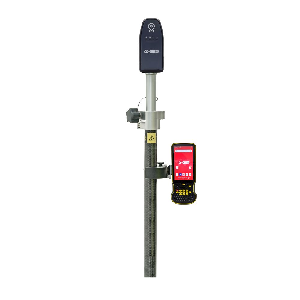
The a-Geo Geopuls RTK Rover Set is a compact handheld laser RTK GNSS solution for surveyors, construction teams, GIS users and drone mapping crews who need fast, flexible point measurement in the field. The set combines the GeoPuls laser RTK receiver with an S60III data collector and SurPro6.0 field software for GNSS surveying, stakeout, laser measurement and project data handling.
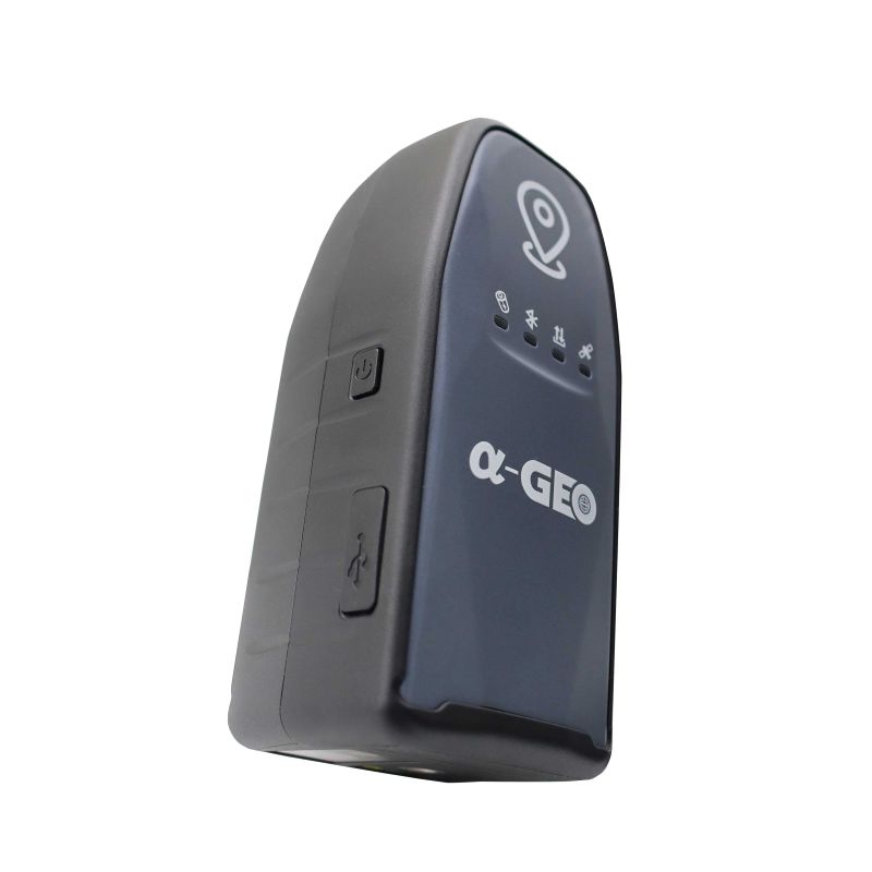
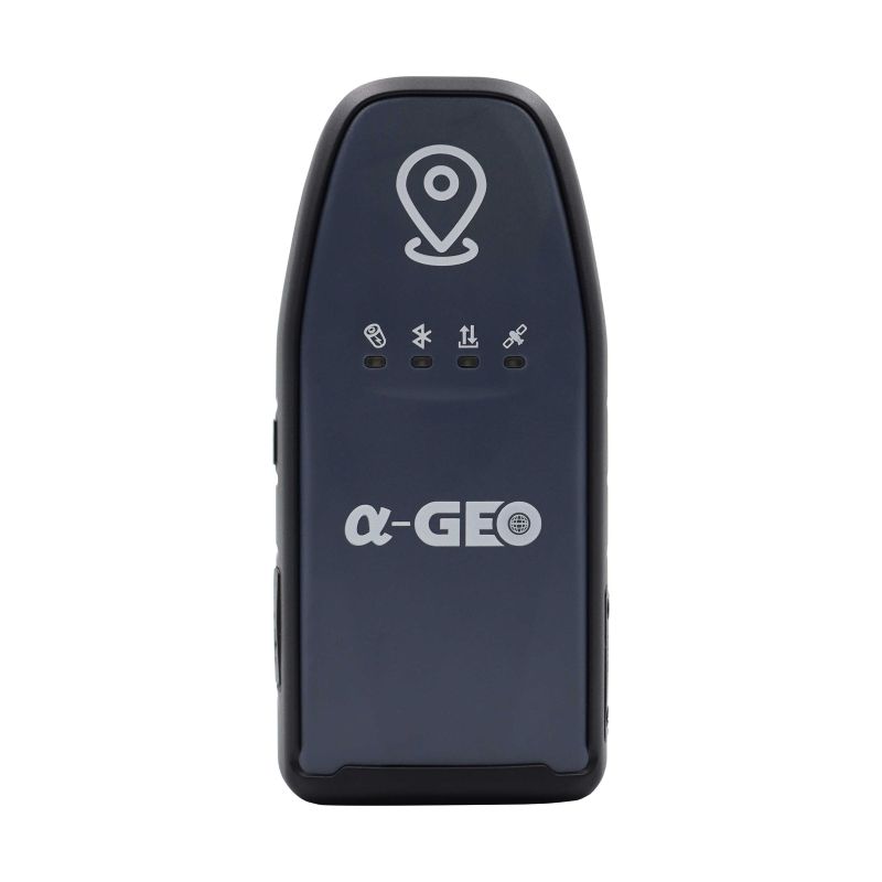
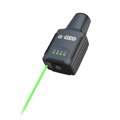
With its green laser, 120° IMU tilt compensation and lightweight 300 g receiver body, the GeoPuls is especially useful when a point is difficult, unsafe or time-consuming to measure with a traditional pole setup.
a-Geo Geopuls RTK Rover Set Highlights
| Product type | Handheld laser RTK GNSS rover set |
|---|---|
| GNSS channels | 1408 channels |
| Laser surveying | Green laser with ±1 cm + 5 mm/m accuracy |
| IMU tilt compensation | 0–120° tilt range |
| Connectivity | Integrated 4G modem, dual-mode Bluetooth and USB Type-C |
| Field durability | IP67 rated, 300 g receiver, 2 m drop specification |
Valued customers:


Find RTK Networks
Search NTRIP providers and connect to reliable RTK correction services.
Description
a-Geo Geopuls RTK Rover Set
The a-Geo Geopuls RTK Rover Set is a complete handheld laser RTK GNSS package for accurate field measurement, mapping and stakeout work. It includes the GeoPuls laser RTK receiver, the rugged S60III data collector and SurPro6.0 Android field software, giving field crews a practical rover workflow for collecting points, checking positions, setting out designs and managing project data on site.
This rover set is built for users who want more flexibility than a traditional pole-only GNSS setup. The GeoPuls combines RTK GNSS positioning with green laser measurement and 120° IMU tilt compensation, making it useful when a point cannot easily be occupied directly with a pole. For construction workers, surveyors, GIS teams, engineers and drone mapping crews, this can save time around walls, fences, trenches, road edges, stockpiles, embankments and other difficult field conditions.
Handheld Laser RTK for Hard-to-Reach Points
The GeoPuls is designed around a handheld RTK workflow with an integrated green laser. In real fieldwork, this helps when the target point is awkward, obstructed or unsafe to stand on. Instead of always placing a pole directly on the point, users can aim the laser and collect the coordinate more flexibly.
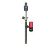
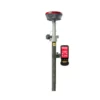
The green laser is especially useful for aiming outdoors and helps field crews work faster when measuring corners, edges, drainage features, building details, slopes or other points where a traditional vertical pole setup is less convenient. The receiver can also be used in pole mode, so users can switch between familiar GNSS rover work and laser-assisted measurement depending on the job.
120° IMU Tilt Compensation
The built-in IMU supports tilt compensation from 0° to 120°. This is useful when the receiver or pole cannot be held perfectly level, such as near obstacles, on uneven terrain, next to buildings or around vegetation. For everyday construction and survey work, tilt compensation helps users collect and stake points with fewer interruptions while keeping the measurement process controlled.
The IMU is designed for fast initialization and field use without the constant calibration routines often associated with older tilt systems. This makes the GeoPuls suitable for crews that need a simple, mobile RTK solution for fast point collection and layout tasks.
Multi-Constellation GNSS Performance
The GeoPuls uses a 1408-channel GNSS board and tracks GPS, GLONASS, BeiDou, Galileo, QZSS, SBAS and IRNSS signals. Broad constellation support helps maintain a stronger satellite environment in mixed field conditions, especially when working near buildings, trees or other partial obstructions.
RTK surveying accuracy is specified at ±8 mm + 1.0 ppm horizontally and ±15 mm + 1.0 ppm vertically. Static GNSS surveying accuracy is specified at ±2.5 mm + 0.5 ppm horizontally and ±5 mm + 0.5 ppm vertically. As with any GNSS receiver, real field accuracy depends on satellite geometry, correction quality, multipath, obstructions, baseline length and correct setup.
Integrated 4G for RTK Corrections
The GeoPuls includes an integrated full-frequency multi-band 4G modem for receiving RTK correction data through mobile networks. This makes it well suited for users working with NTRIP correction services and RTK network providers. The receiver supports RTCM2.X and RTCM3.X correction formats.
This rover set does not include a UHF radio. It is best suited for users who mainly work with internet-based RTK corrections and want a clean, compact rover setup without external radio configuration.
S60III Data Collector for Field Control
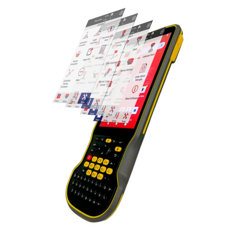
The included S60III data collector is a rugged Android handheld designed for field measurement and mapping work. It runs Android 12 with GMS support and uses a Qualcomm SDM 662 octa-core processor, 4 GB RAM and 64 GB internal storage. The 5.5-inch full HD display is designed for outdoor visibility, while the physical QWERTY keyboard helps with fast point naming, coding and data input in the field.
The S60III includes Bluetooth 5.0, dual-band Wi-Fi, 4G network support, USB Type-C and NFC. Its 9000 mAh battery is specified for long operating time, making it suitable for full field days when properly charged. With IP68 protection and a rugged housing, it is made for demanding site conditions where dust, water, knocks and daily handling are part of the job.
SurPro6.0 Field Software Workflow
SurPro6.0 field software gives the rover set the tools needed for practical surveying and construction workflows. Users can create and manage projects, configure coordinate systems, handle localization, manage point databases, set up GNSS communication and organize field data directly on the data collector.
For measurement work, SurPro6.0 supports point survey, detail survey, control point survey and point stakeout. These tools are useful for topographic surveying, construction checks, GIS point collection and setting out known coordinates on site.
The software also includes CAD-related tools for displaying drawings, working with layers, importing DXF and DWG files, exporting DXF files and staking CAD graphics in the field. For construction and infrastructure work, SurPro6.0 also supports line stakeout, DSM stakeout and road design stake functions, helping crews connect design data with real positions on the ground.
Built for Surveying, Construction, GIS and Drone Mapping
The a-Geo Geopuls RTK Rover Set is suitable for a wide range of professional GNSS field applications. Surveyors can use it for detail measurement, topo work, control checks and stakeout. Construction teams can use it for site layout, road work, earthworks and checking built positions against design data. GIS users can collect accurate asset locations, while drone pilots can use it to measure ground control points and checkpoints for mapping projects.
- Topographic surveying and detail measurement
- Construction layout and site checks
- Point, line and CAD-based stakeout
- GIS asset mapping and field data collection
- Road, earthwork and infrastructure workflows
- Drone ground control point and checkpoint measurement
Compact Receiver for Outdoor Fieldwork
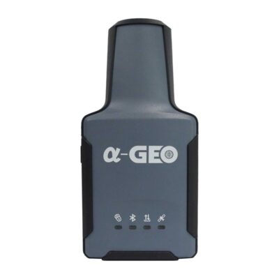
The GeoPuls receiver weighs approximately 300 g and has a compact handheld body, making it easy to carry around busy sites. It is rated IP67 for dust and water protection and is specified to survive a 2 m drop onto concrete. The receiver also supports USB Type-C fast charging and has an internal 3350 mAh battery with more than 12 hours of specified battery life.
For field crews, this means the rover is not only accurate, but also practical to handle during long days outside. The compact size is especially useful for quick measurements, site checks and situations where a larger GNSS receiver setup is less convenient.
Why Buy from Global GPS Systems?
When you buy the a-Geo Geopuls RTK Rover Set from Global GPS Systems, you get more than the hardware alone. Our team helps customers choose the right GNSS setup for their work, whether they are active in surveying, construction, GIS, engineering or drone mapping.
Global GPS Systems ships worldwide from the Netherlands with insured delivery. We can support international buyers with import, export, tax and duty questions where relevant. Warranty is included, and our product specialists can help with RTK correction services, receiver setup and practical field use.
If you are comparing laser RTK receivers, IMU GNSS rovers or complete rover sets, the a-Geo Geopuls RTK Rover Set is a strong option for users who need accurate RTK performance with extra flexibility for hard-to-reach point measurement.
Datasheets & Manuals
Datasheets and manuals
Specifications
a-Geo GeoPuls RTK Rover Set Specifications
Product Overview
| Product Name | a-Geo GeoPuls RTK Rover Set |
|---|---|
| Product Type | RTK GNSS rover set with handheld laser RTK receiver |
| Main Components | GeoPuls handheld laser RTK receiver, S60III rugged data collector and SurPro6.0 Android field software |
| Recommended Users | Surveyors, construction professionals, GIS teams, engineering field crews, infrastructure teams and mapping users |
| Typical Applications | RTK surveying, topographic measurement, construction layout, point stakeout, CAD stakeout, GIS data collection, road and infrastructure workflows, drone mapping support and hard-to-reach point measurement |
| Measurement Workflow | Supports handheld laser RTK measurement and conventional pole-based GNSS rover operation |
GeoPuls GNSS Receiver – Key Features
| Receiver Type | Handheld laser RTK GNSS receiver |
|---|---|
| GNSS Channels | 1408 channels |
| Laser Surveying | Integrated green laser measurement for hard-to-reach points |
| IMU Tilt Compensation | 0-120° |
| Cellular Connectivity | Integrated full-frequency multi-band 4G modem |
| Bluetooth | Dual-mode Bluetooth |
| Protection Rating | IP67 dustproof and waterproof |
| UHF Radio | Not included |
GeoPuls GNSS Performance
| GPS Signals | L1 C/A, L2C, L2P, L5 |
|---|---|
| GLONASS Signals | L1, L2 |
| BeiDou Signals | B1, B2, B3, B1C, B2a, B2b |
| Galileo Signals | E1, E5a, E5b, E6 |
| QZSS Signals | L1, L2, L5, L6 |
| SBAS Support | WAAS, EGNOS, MSAS, GAGAN, SDCM |
| IRNSS Support | Supported |
| Cold Start | <60 s |
| Hot Start | <15 s |
| Positioning Output Rate | 1 Hz-50 Hz |
| Signal Reacquisition | <1 s |
| RTK Initialization Time | <5 s |
| Initialization Reliability | >99.99% |
| Time Accuracy | 20 ns |
GeoPuls Positioning Accuracy
| Mode | Horizontal Accuracy | Vertical Accuracy |
|---|---|---|
| Static GNSS Surveying | ±2.5 mm + 0.5 ppm | ±5 mm + 0.5 ppm |
| RTK Surveying | ±8 mm + 1.0 ppm | ±15 mm + 1.0 ppm |
| Laser Surveying Accuracy | ±1 cm + 5 mm/m |
|---|---|
| Accuracy Notes | Precision and reliability may vary depending on multipath, obstructions, satellite geometry, atmospheric conditions, baseline length, correction quality and field setup. |
GeoPuls IMU Specifications
| IMU | Supported |
|---|---|
| IMU Initialization | 4D IMU initialization in 3 seconds |
| IMU Update Rate | 400 Hz |
| IMU Accuracy | <2.5 cm within 120° |
| Tilt Compensation Range | 0-120° |
| Magnetic Interference Resistance | Calibration-free IMU designed to be immune to magnetic interference |
GeoPuls Communication and Data
| I/O Interface | USB Type-C |
|---|---|
| Cellular Modem | Integrated full-frequency multi-band 4G modem |
| Supported Cellular Standards | WCDMA, CDMA2000, TDD-LTE, FDD-LTE |
| Bluetooth | Dual-mode Bluetooth |
| Differential Data Format | RTCM2.X, RTCM3.X |
| GPS Output Data Format | NMEA 0183 RTK, binary code |
| RTK Correction Workflow | Supports internet-based RTK correction workflows through integrated 4G connectivity |
| UHF Radio | None |
GeoPuls Electrical Specifications
| Power Input | 5 V / 2 A |
|---|---|
| Charging | USB Type-C fast charging |
| Internal Battery | 3350 mAh |
| Battery Life | >12 h |
GeoPuls Physical and Environmental Specifications
| Material | Polymer engineering materials |
|---|---|
| Dimensions | 136.5 x 65 x 56 mm |
| Weight | 300 g |
| Key | Power button |
| Indicators | Power indicator, data link indicator, satellite indicator, Bluetooth indicator |
| Operating Temperature | -20°C to +75°C |
| Storage Temperature | -40°C to +85°C |
| Protection Rating | IP67 dustproof, protected from 30-minute immersion to a depth of 1 m |
| Shock Resistance | Survives 2 m drop onto concrete |
| Vibration | MIL-STD-810G |
| Humidity | 100%, condensing |
S60III Data Collector – System Specifications
| Model | a-Geo S60III rugged data collector |
|---|---|
| Operating System | Android 12 with GMS support |
| CPU | Qualcomm SDM 662 octa-core 2.0 GHz |
| RAM | 4 GB SDRAM |
| Internal Storage | 64 GB flash memory |
| Memory Card | MicroSDHC up to 128 GB |
| Keyboard | QWERTY key layout with shortcut buttons |
| Google Services | GMS certification supported |
S60III Display and Physical Specifications
| Display Size | 5.5-inch LTPS LCD capacitive multi-touch display |
|---|---|
| Display Resolution | 1920 x 1080 pixels, HD+, 401 ppi |
| Display Brightness | 500 nits |
| Display Protection | Gorilla Glass |
| Dimensions | 228 x 96 x 21 mm |
| Weight | 420 g with battery |
| Design | Rugged handheld terminal with standard English keyboard |
S60III Communications
| SIM Card Type | Nano-SIM card |
|---|---|
| GSM Bands | 850 / 900 / 1800 / 1900 |
| WCDMA Bands | B1 / B2 / B4 / B5 / B8 |
| LTE-TDD Bands | B34 / B38 / B39 / B40 / B41 |
| LTE-FDD Bands | B1 / B2 / B3 / B4 / B5 / B7 / B8 / B12 / B13 / B17 / B20 / B25 / B26 / B28 |
| Wi-Fi | 802.11 a/b/g/n/ac, access point mode, 2.4 GHz / 5 GHz |
| Bluetooth | Bluetooth 5.0 |
| USB | USB Type-C, OTG supported |
| NFC | Supported |
S60III Electrical and Environmental Specifications
| Battery Type | Li-ion battery |
|---|---|
| Battery Capacity | 9000 mAh |
| Operating Time | 22 h |
| Charging Time | 4 h typical |
| Operating Temperature | -20°C to +65°C / -4°F to +149°F |
| Storage Temperature | -30°C to +70°C / -22°F to +158°F |
| Dust and Water Protection | IP68 |
| Humidity | 5%-95%, non-condensing |
| Shock and Vibration | 1.2 m / 4 ft fall onto concrete |
S60III Sensors, Multimedia and GNSS
| Rear Camera | 13 MP rear camera with autofocus and flash |
|---|---|
| Internal GNSS | BDS, GPS, GLONASS |
| A-GPS | Supported |
| G-Sensor | Supported |
| Gyroscope | Supported |
| E-Compass | Supported |
| Light Sensor | Supported |
| Speaker | Integrated |
| Microphone | Integrated |
SurPro6.0 Field Software
| Software Platform | SurPro6.0 Android field software |
|---|---|
| Main Software Areas | Project, device, survey and tools |
| Project Functions | Project management, localization, calibration, coordinate system setup, point database, code library management, survey range settings and software settings |
| Device Functions | Communication setup, rover mode, base mode, static mode, device information, device activation and related instrument settings |
| Survey Functions | Point survey, detail survey, control point survey, point stakeout, CAD, line stakeout, DSM stakeout and road design stake |
| CAD Functions | CAD graphic display, layer management, DXF/DWG import, DXF export, linework and CAD graphic stakeout |
| Road and Infrastructure Tools | Road design stake, line stakeout and elevation-related DSM stakeout workflows |
| Utility Tools | Coordinate converter, angle converter, perimeter and area calculation and calculator |
| Project Data Storage | Project data is stored and managed by project folders on the Android device |
Certifications and Compliance
| S60III Certifications | CE, FCC |
|---|---|
| GeoPuls Vibration Standard | MIL-STD-810G |
| Receiver Environmental Protection | GeoPuls: IP67; S60III: IP68 |
Package / Included Items
| Item | Quantity | Notes |
|---|---|---|
| GeoPuls handheld laser RTK receiver | 1 | Main GNSS receiver for laser RTK and pole-based rover measurement |
| S60III rugged data collector | 1 | Android 12 field controller with keyboard, 4G, Wi-Fi, Bluetooth and rugged housing |
| SurPro6.0 field software | 1 | Android field software for survey, stakeout, CAD and project workflows |
| S60III A/C charger | 1 | Standard S60III accessory |
| S60III USB cable | 1 | Standard S60III accessory |
| S60III stylus | 1 | Standard S60III accessory |
| S60III handstrap | 1 | Standard S60III accessory |
Specifications and package contents may vary by configuration, region or manufacturer update. Always check the current configuration before ordering.
FAQ
a-Geo Geopuls RTK Rover Set FAQ
Product Overview
What is the a-Geo Geopuls RTK Rover Set?
The a-Geo Geopuls RTK Rover Set is a compact handheld laser RTK GNSS rover solution for accurate field measurement, mapping, stakeout and construction layout. It combines the GeoPuls handheld laser RTK receiver with an S60III data collector and SurPro6.0 field software.
Who is the GeoPuls RTK Rover Set designed for?
It is designed for surveyors, construction professionals, GIS teams, mapping users, engineering crews, infrastructure teams and drone mapping support users who need accurate GNSS measurements in the field.
What makes the GeoPuls different from a standard GNSS rover?
The GeoPuls combines RTK GNSS positioning with green laser measurement and 120° IMU tilt compensation. This makes it useful for measuring points that are difficult, unsafe or inconvenient to occupy directly with a traditional survey pole.
Can the GeoPuls be used as both a handheld receiver and a pole-mounted rover?
Yes. The GeoPuls is built for flexible workflows and can be used for handheld laser RTK measurement or in a more traditional pole-based GNSS rover setup.
What is included in the rover set?
The rover set includes the GeoPuls handheld laser RTK receiver, an S60III data collector and SurPro6.0 Android field software for field measurement, stakeout and project management workflows.
What industries commonly use this type of RTK rover?
This type of RTK rover is commonly used in land surveying, construction, civil engineering, infrastructure, GIS mapping, drone mapping support, roadwork, earthworks and asset data collection.
Measurement, Accuracy and GNSS Performance
How accurate is the a-Geo Geopuls for RTK surveying?
The specified RTK surveying accuracy is ±8 mm + 1.0 ppm horizontally and ±15 mm + 1.0 ppm vertically. Actual field accuracy can depend on satellite conditions, correction quality, multipath, obstructions and setup.
How accurate is the laser surveying function?
The specified laser surveying accuracy is ±1 cm + 5 mm/m. This allows the GeoPuls to measure coordinates using the integrated laser when direct pole placement is difficult.
What is the benefit of the green laser?
The green laser helps users aim more clearly in bright outdoor conditions, making laser measurement easier for field tasks such as measuring edges, corners, drainage features, embankments and other hard-to-reach points.
What GNSS constellations does the GeoPuls support?
The GeoPuls supports GPS, GLONASS, BeiDou, Galileo, QZSS, SBAS and IRNSS. Its 1408-channel GNSS chipset helps provide strong multi-constellation satellite tracking for professional field positioning.
What is IMU tilt compensation?
IMU tilt compensation allows the receiver to measure or stake out points even when the device or pole is tilted. This helps users work faster around obstacles, slopes, vegetation, walls and other locations where keeping a pole perfectly vertical is difficult.
What tilt angle does the GeoPuls support?
The GeoPuls supports IMU tilt compensation from 0° to 120°. The IMU is designed for fast initialization and does not require frequent calibration.
Can the GeoPuls measure hard-to-reach points?
Yes. The combination of laser measurement and high-angle IMU tilt compensation makes the GeoPuls suitable for measuring points that are awkward, obstructed or unsafe to occupy directly with a survey pole.
Connectivity, Corrections and Software
Does the GeoPuls support RTK correction services?
Yes. The GeoPuls has an integrated full-frequency multi-band 4G modem and supports RTCM2.X and RTCM3.X differential data formats, making it suitable for internet-based RTK correction workflows such as NTRIP.
Does the GeoPuls have a UHF radio?
No. The GeoPuls is specified without UHF radio. It is best suited for RTK workflows that use the integrated 4G modem and internet-based correction services.
What field software is included with the rover set?
The rover set includes SurPro6.0 Android field software. It supports common survey workflows such as project setup, device connection, point survey, control point survey, point stakeout, CAD functions, line stakeout and road-related tools.
Can the GeoPuls be used for CAD stakeout?
Yes. SurPro6.0 supports CAD graphic display, layer management, DXF and DWG import, DXF export and CAD graphic stakeout functions for construction and engineering workflows.
Can it be used for road and infrastructure workflows?
Yes. SurPro6.0 includes tools for line stakeout, DSM stakeout and road design stake functions, making the rover set useful for infrastructure, roadwork and earthwork applications.
What devices can the GeoPuls connect to?
The GeoPuls supports USB Type-C and dual-mode Bluetooth. Its Bluetooth connectivity is suitable for Android, iOS and PC device connections, depending on the workflow and software setup.
Field Use, Durability and Practical Applications
Is the GeoPuls suitable for harsh outdoor conditions?
Yes. The receiver has an IP67 dustproof and waterproof rating, is specified to survive a 2 m drop onto concrete and has an operating temperature range from -20°C to +75°C.
How long does the battery last?
The GeoPuls has an internal 3350 mAh battery with a specified battery life of more than 12 hours. It also supports USB Type-C fast charging.
How heavy is the GeoPuls receiver?
The GeoPuls receiver weighs approximately 300 g. Its compact handheld design makes it suitable for mobile field measurement and flexible RTK workflows.
Can the GeoPuls be used for topographic surveying?
Yes. The GeoPuls is suitable for topographic surveying, detail measurement, point collection, control point survey and other common GNSS field survey tasks.
Can the GeoPuls be used for construction layout?
Yes. The rover set can be used for construction layout, point stakeout, line stakeout, CAD-based stakeout, site checks and measurement tasks where accurate RTK positioning is required.
Can it be used for drone mapping support?
Yes. The GeoPuls can be used to collect ground control points and check points for drone mapping workflows, helping connect aerial mapping data with accurate ground measurements.
Additional information
| GNSS feature | GNSS with IMU, GNSS with Laser |
|---|
Reviews (0)
Only logged in customers who have purchased this product may leave a review.
Reviews
There are no reviews yet