

 GPS & GNSS
 Lidar scanning
 Total Station


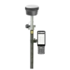
FJD Trion V10L Laser RTK GNSS Rover and Base Set
Get the best price for your setup
Contact our experts for the best possible price and configuration.
- Fast response
- Expert configuration advice
- No overpaying for features you do not need
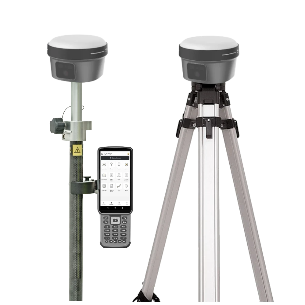
The FJD Trion V10L Rover and Base Set is a complete local RTK GNSS surveying system that combines centimetre-level positioning with non-contact laser measurement, camera-assisted target selection and visual stakeout. One receiver operates as the RTK base station while the other works as the rover, allowing surveyors, construction crews, engineers and GIS professionals to establish their own correction source where network RTK is unavailable or unreliable.
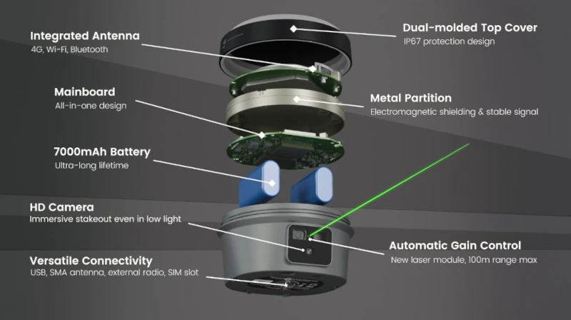
The V10L rover uses a visible green laser and dual 2 MP cameras to measure and set out points that are difficult or unsafe to reach with a survey pole. EasyFix automatic alignment and zoom help the operator identify the intended target, while the second-generation IMU supports calibration-free tilt compensation up to 60°. Both receivers provide 1408-channel multi-constellation GNSS tracking, integrated UHF and 4G communications, Wi-Fi, Bluetooth and NFC connectivity.
FJD Trion V10L Rover and Base Set Highlights
| System configuration | Two V10L receivers for independent local RTK base and rover operation |
|---|---|
| Laser surveying | Visible green laser for non-contact measurement and laser stakeout |
| Laser accuracy | ≤2 cm within 5 m, ≤3 cm within 10 m and ≤4 cm within 15 m |
| Laser range | Up to 80 m with Automatic Gain Control |
| IMU tilt compensation | Calibration-free second-generation IMU supporting 0–60° tilt |
| RTK accuracy | 8 mm + 1 ppm horizontal and 15 mm + 1 ppm vertical RMS |
| Visual stakeout | AR guidance with dual 2 MP cameras and EasyFix target alignment |
| GNSS tracking | 1408 channels supporting GPS, GLONASS, Galileo, BeiDou, QZSS, IRNSS and SBAS |
| Connectivity | Integrated UHF, 4G, Wi-Fi, Bluetooth and NFC |
| Field protection | IP68 rated and designed to survive a 2 m pole drop |


Valued customers:










Find RTK Networks
Search NTRIP providers and connect to reliable RTK correction services.
Description
FJD Trion V10L Laser RTK Rover and Base Set
The FJD Trion V10L Rover and Base Set provides a complete local RTK surveying solution built around two professional laser GNSS receivers. One V10L is configured as the fixed base station and transmits correction data, while the second receiver operates as the rover. This allows crews to achieve centimetre-level positioning without depending entirely on a regional NTRIP or CORS service.
The system is designed for land surveyors, construction teams, civil engineers, utility crews, GIS professionals and drone mapping operators. It is particularly useful on remote sites, infrastructure corridors, agricultural land, quarries, coastal projects and construction areas where mobile coverage or access to a permanent correction network cannot be guaranteed.
Independent Local RTK Corrections
During a local base-and-rover survey, the base receiver remains at a known or calculated position and continuously observes the available satellites. It sends real-time correction information to the rover through the integrated UHF radio. The rover combines these corrections with its own GNSS observations to calculate accurate coordinates in the field.
This workflow gives the crew direct control over the correction source and can provide more reliable project coverage than a mobile-data connection in remote or poorly connected areas. Either receiver can be assigned to the base or rover role according to the project setup, making the two-receiver system flexible across different jobs.
Non-Contact Laser Measurement
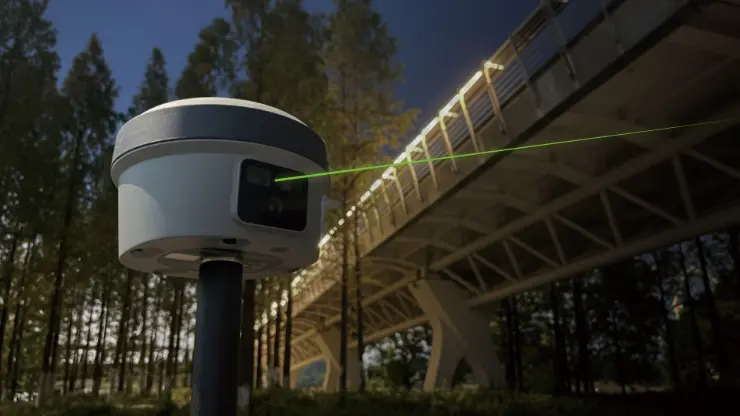
The V10L rover can measure a target without placing the survey pole tip directly on it. The operator aims the visible green laser at a wall corner, structural feature, riverbank, excavation edge, bridge component or other inaccessible point and records its coordinate from a safer or more convenient position.
Specified laser measurement accuracy is ≤2 cm within 5 metres, ≤3 cm within 10 metres and ≤4 cm within 15 metres. Automatic Gain Control supports laser ranging at distances of up to 80 metres by adapting to changes in target surface, light and distance. Actual results depend on RTK quality, target reflectivity, visibility, aiming stability and surrounding conditions.
Visible Green Laser for Clear Targeting
The visible green laser gives the operator a clear indication of the selected measuring or stakeout point. It is designed to remain practical in bright daylight as well as darker working environments, making target selection easier than with a laser that cannot be seen clearly on the surface.
A 2 MP night-vision camera supports work in low-light locations such as beneath bridges, around underpasses, inside partially covered structures and during early-morning or evening surveys. The live camera image allows the operator to confirm the selected target before accepting the measurement.
EasyFix Automatic Alignment
EasyFix combines the receiver camera, automatic alignment and zoom assistance to help the user locate and hold the intended target. This is useful when the point is small, located at a distance or surrounded by several similar features.
For tasks such as recording wall corners, bolts, utility markers, structural edges and road details, EasyFix can reduce repeated manual adjustments. The operator can view the feature through the controller, confirm the selected point and complete the observation without physically approaching the target.
AR and Laser Stakeout
The dual-camera system provides real-scene AR stakeout guidance. Direction and distance information are displayed over a live image of the working area, allowing the user to see where the design coordinate is located in relation to the surrounding site.
As the rover approaches the point, forward and downward views help guide the operator towards the target. Laser guidance can then indicate a position on a nearby surface without requiring the pole to be placed directly over every coordinate. This is practical for setting out near walls, barriers, excavation edges, traffic routes and restricted areas.
Second-Generation 60° IMU Tilt Compensation
The integrated IMU supports survey pole tilt angles from 0° to 60°. The pole does not need to remain perfectly vertical during every measurement, allowing crews to collect points beside walls, fences, vehicles, machinery, trenches and other obstacles.
The second-generation IMU is calibration-free and designed for fast initialization during normal field movement. Specified RTK accuracy with tilt compensation is 8 mm plus 0.6 mm for each degree of tilt under suitable conditions. This helps the operator work efficiently while avoiding the repeated stopping and careful pole levelling associated with conventional measurement methods.
1408-Channel Multi-Constellation GNSS
Each V10L receiver uses a 1408-channel GNSS board that tracks signals from GPS, GLONASS, Galileo, BeiDou, QZSS, IRNSS and SBAS. Access to multiple constellations and frequencies increases the number of satellites available for positioning and can improve solution availability near buildings, vegetation and other partial obstructions.
Under suitable RTK conditions, specified accuracy is 8 mm + 1 ppm horizontally and 15 mm + 1 ppm vertically. Initialization is specified at under five seconds with reliability above 99.9%. Real field performance depends on the accuracy of the base position, baseline length, correction quality, satellite geometry, multipath and atmospheric conditions.
UHF Radio and Network RTK Connectivity
Integrated UHF radios allow correction data to be transmitted directly between the base and rover without an internet connection. This is the main advantage of the two-receiver set for projects outside established network RTK coverage.
The receivers also include integrated 4G modems for connection to compatible NTRIP or CORS services through a SIM card. This means either receiver can also be used as a network RTK rover where mobile coverage and correction access are available. Wi-Fi, Bluetooth, NFC, USB Type-C and external antenna connections provide additional options for controllers, data transfer and field configuration.
V10La and V10Li Options
The V10L platform is available in V10La and V10Li versions. The V10La supports non-contact laser measurement, laser stakeout, AR guidance and IMU tilt surveying. The V10Li adds image-based visual measurement, allowing several points to be selected from captured imagery.
The V10Li visual survey function has a typical specified accuracy of approximately 3 cm over a range of 2 to 15 metres. This version is useful for jobs involving several inaccessible targets or complex scenes, while the V10La is suited to standard point-by-point laser workflows. The supplied version depends on the chosen package configuration.
Receiver Display and Field Controls
A colour OLED display on each receiver provides direct access to important operating information. Status indicators, physical buttons and audio feedback allow crews to check GNSS reception, radio communication, battery condition and working mode without relying entirely on the field controller.
This is particularly useful during base station setup. The operator can verify that the base is tracking satellites and transmitting corrections correctly before moving away with the rover.
Rugged Equipment for Outdoor Projects
Each V10L receiver has an IP68-rated housing for protection against dust and water ingress. The enclosure is also designed to survive a two-metre pole drop, providing the durability required for daily use on construction, engineering and surveying projects.
At approximately 980 g per receiver, the V10L remains manageable on a survey pole while integrating the GNSS board, laser, cameras, UHF radio, 4G modem and battery. Its specified operating temperature range of approximately -35°C to 65°C supports work across a wide range of outdoor environments.
Battery Capacity for Base and Rover Work
The integrated 7000 mAh battery provides specified operating times of up to 15 hours in rover mode, 10 hours in base mode and more than 25 hours during static observations. Actual operating time varies with UHF radio power, laser use, camera activity, mobile connectivity, temperature and receiver settings.
Support for 30 W Power Delivery charging helps reduce downtime between working days. An external 9–28 V DC power input can be used to support longer base station occupations and extended projects.
Typical Applications
- Independent local RTK base and rover surveying
- Topographic and cadastral surveys
- Construction layout and laser stakeout
- Road, railway and bridge projects
- Utility and GIS asset mapping
- Wall corners and structural detail measurement
- Riverbanks, drainage and shoreline projects
- Excavation edges and earthworks
- Industrial sites and substations
- Ground control points for drone mapping
- Remote sites without reliable network RTK coverage
Support from Global GPS Systems
Setting up a dependable local RTK system involves more than selecting two receivers. Base coordinates, antenna heights, radio frequencies, transmission power, coordinate systems, site calibration and controller software all influence the quality of the final results. Global GPS Systems can help users configure the V10L Rover and Base Set for their projects and select the appropriate receiver version, field controller and accessories.
The FJD Trion V10L Rover and Base Set is a flexible choice for teams that need an independent correction source together with laser measurement, visual stakeout and tilt surveying. It combines conventional centimetre-level GNSS work with safer non-contact measurement for points that cannot be reached efficiently with a survey pole.
Datasheets & Manuals
Specifications
FJD Trion V10L Rover & Base Set Specifications
System Overview
| Product type | Professional dual-receiver RTK GNSS rover and base station set with non-contact laser measurement |
|---|---|
| Receiver model | FJD Trion V10L |
| Receiver quantity | 2 receivers for rover and base station operation |
| Available receiver variants | V10La and V10Li; supplied variant depends on the selected configuration |
| Core technologies | 1408-channel multi-constellation GNSS, RTK positioning, visible green laser, EasyFix targeting, dual cameras, second-generation IMU tilt compensation, 4G modem and integrated UHF radio |
| Primary functions | RTK surveying, local base station operation, non-contact laser measurement, laser-assisted stakeout, AR visual stakeout, tilt surveying, static surveying, PPK and PPP |
| Typical applications | Land surveying, topographic surveying, cadastral work, construction layout, civil engineering, infrastructure projects, utility mapping, mining, forestry, precision agriculture and geospatial data collection |
| Hard-to-reach applications | Suitable for measuring walls, corners, bridge structures, riverbanks, underpasses, excavation edges, substations, hazardous areas and other points that cannot be occupied directly with a survey pole |
Rover and Base Configuration
| Function | Rover Receiver | Base Receiver |
|---|---|---|
| Primary role | Collects survey points and performs stakeout in the field | Generates RTK correction data from a fixed or known position |
| Correction link | Receives corrections through UHF radio or a compatible network RTK service | Transmits corrections through the integrated UHF radio or supported network workflow |
| Laser measurement | Supported | Available when the receiver is reconfigured for rover operation |
| Laser-assisted stakeout | Supported | Available when the receiver is reconfigured for rover operation |
| AR visual stakeout | Supported | Available when the receiver is reconfigured for rover operation |
| IMU tilt compensation | Supported up to 60° | Available when the receiver is reconfigured for rover operation |
| Typical internal battery runtime | Up to 15 hours | Up to 10 hours |
V10La and V10Li Model Comparison
| Function | V10La | V10Li |
|---|---|---|
| RTK GNSS positioning | Supported | Supported |
| Non-contact laser measurement | Supported | Supported |
| Laser-assisted stakeout | Supported | Supported |
| AR visual stakeout | Supported | Supported |
| Visual measurement from imagery | Not supported | Supported |
| Multiple-point selection from one image | Not supported | Supported |
| Recommended workflow | RTK surveying, point-by-point laser measurement and laser stakeout | RTK and laser workflows plus visual measurement of multiple targets or complex scenes |
GNSS Tracking
| GNSS channels | 1408 |
|---|---|
| GPS signals | L1A, L1C, L2C, L2P and L5 |
| GLONASS signals | L1, L2 and L3 |
| BeiDou signals | B1I, B2I, B3I, B1C, B2a and B2b |
| Galileo signals | E1, E5a, E5b and E6 |
| QZSS signals | L1, L2C, L5 and L6 |
| IRNSS / NavIC signals | L5 |
| SBAS signals | L1 C/A |
| HAS-PPP signal | Galileo E6 |
| Firmware-dependent signals | QZSS L6 and IRNSS L5 support may require a firmware update |
| Positioning update rates | 1 Hz, 2 Hz, 5 Hz and 10 Hz |
Positioning Accuracy
| Positioning Mode | Horizontal Accuracy | Vertical Accuracy |
|---|---|---|
| RTK | 8 mm + 1 ppm RMS | 15 mm + 1 ppm RMS |
| Post-processing static | 2.5 mm + 0.5 ppm RMS | 5 mm + 0.5 ppm RMS |
| High-precision static | 2.5 mm + 0.1 ppm RMS | 3.5 mm + 0.4 ppm RMS |
| PPK | 3 mm + 1 ppm RMS | 5 mm + 1 ppm RMS |
| PPP | ±20 cm RMS | ±40 cm RMS |
| Code differential | 0.4 m RMS | 0.8 m RMS |
| Autonomous positioning | 1.5 m RMS | 2.5 m RMS |
| SBAS | 60 cm | |
RTK Initialization and Signal Acquisition
| RTK initialization time | Less than 5 seconds |
|---|---|
| RTK initialization reliability | Greater than 99.9% |
| Cold-start time to first fix | Less than 20 seconds |
| Warm-start time to first fix | Less than 5 seconds |
| Signal reacquisition | Less than 1 second |
| RTK performance condition | Published performance is based on open-sky operating conditions |
Laser Measurement
| Laser function | Non-contact distance measurement and laser-assisted stakeout |
|---|---|
| Laser type | Visible Class 2M green laser |
| Laser wavelength | 520 nm ±20 nm |
| Maximum laser output | 0.475 mW |
| Measuring range | 0 m to 80 m, depending on the target surface, ambient light and environmental conditions |
| Accuracy within 5 m | ≤2 cm |
| Accuracy within 10 m | ≤3 cm |
| Accuracy within 15 m | ≤4 cm |
| Ranging accuracy formula | ±(5 + 100 × 10-6 × D) mm, where D is the measuring distance in millimetres |
| Automatic Gain Control | Automatically adapts ranging response to changes in target reflectivity, ambient light and distance |
| Daylight visibility | Green laser is designed for visibility in bright sunlight and low-light conditions |
| Non-contact operation | Allows points to be measured or staked without positioning the survey pole directly on the target |
| Laser safety | Do not stare into the laser beam or direct it toward people, animals, vehicles or aircraft |
EasyFix Targeting
| EasyFix function | Camera-assisted target acquisition for laser measurement and stakeout |
|---|---|
| Automatic alignment | Automatically assists with aligning the live camera view and intended target |
| Automatic zoom | Automatically adjusts the camera view to help identify and select distant points |
| Automatic focus | Assists with maintaining a clear target preview during compatible measurement workflows |
| Target preview | Displays a live camera view so the operator can verify the intended target before measuring |
| Low-light targeting | Night-vision imaging supports aiming, measurement and stakeout in dark environments |
IMU Tilt Compensation
| IMU generation | Second-generation IMU |
|---|---|
| Tilt range | 0° to 60° |
| Tilt-compensated RTK accuracy | 8 mm + 0.6 mm per degree of tilt RMS |
| Calibration requirement | No manual calibration required |
| Initialization | Automatic initialization designed for immediate field use |
| Startup performance | Manufacturer-stated startup improvement of up to 60% compared with the previous-generation IMU |
| Magnetic interference resistance | IMU tilt measurement is designed to remain unaffected by magnetic disturbances |
| Electronic leveling | Electronic bubble display |
Cameras and Visual Functions
| Camera system | Dual-camera system with front and bottom viewing functions |
|---|---|
| Camera resolution | Dual 2 MP cameras |
| Night-vision camera | Integrated 2 MP night-vision camera |
| Field of view | 88° |
| Vertical field of view | 63° |
| Horizontal field of view | 76° |
| Shutter type | Global shutter |
| Camera sensitivity | Starlight-grade low-light imaging |
| Sensor pixel size | 3 µm × 3 µm |
| Low-light imaging | Designed to maintain full-colour imaging at low illumination levels |
| AR visual stakeout | Displays real-scene direction and distance guidance to the required stakeout point |
| Camera view switching | Supports front and bottom camera views during compatible stakeout workflows |
| Visual measurement availability | Supported on V10Li configurations |
| Visual survey accuracy | Typically 3 cm over a 2 m to 15 m range on V10Li configurations |
| Visual capture method | Video photogrammetry |
| Maximum image-group capture time | 30 seconds |
| Approximate image-group size | 30 MB |
Integrated UHF Radio
| Radio function | Integrated UHF transmitter and receiver in each V10L receiver |
|---|---|
| Available frequency bands | 410 MHz to 470 MHz or 902 MHz to 928 MHz, depending on regional configuration |
| Transmit power | 2 W |
| Supported protocols | TRIMTALK, TRIMMARK III, TT450S, TRANSEOT, Satel 3AS 4FSK and LoRa |
| Radio link rate | 9,600 bps to 19,200 bps |
| Typical radio range | 6 km to 12 km |
| Maximum stated radio range | Up to 16 km under optimal conditions |
| Base-to-rover operation | Allows the base receiver to transmit correction data directly to the rover without a third-party RTK correction network |
| External radio support | Supports compatible external-radio workflows where additional transmit power or range is required |
| UHF antenna connection | Dedicated UHF antenna port |
Cellular and Wireless Connectivity
| Cellular modem | Integrated 4G modem |
|---|---|
| Supported cellular standards | TDD-LTE, FDD-LTE, WCDMA, EDGE, GPRS and GSM |
| SIM card type | Nano-SIM |
| Wi-Fi | 2.4 GHz and 5 GHz, IEEE 802.11a/b/g/n/ac |
| Bluetooth | Supported for compatible controller and accessory connections |
| NFC | Supported for rapid device pairing |
| Network RTK | Supports compatible NTRIP and network correction services through the integrated cellular modem |
| Controller connection | Supports wireless connection to compatible FJD keyboard controllers and tablet controllers |
Data Formats and Storage
| NMEA-0183 | Input and output |
|---|---|
| RTCM 3.x | Input and output |
| RTCM 2.x | Input |
| CMR | Input |
| Internal storage | 32 GB per receiver |
| Supported data workflows | Real-time correction data, static GNSS observation logging, PPK, visual-measurement imagery, project data and field-to-office transfer |
Ports and Interfaces
| Multi-function port | 7-pin LEMO connector for data communication and external power |
|---|---|
| USB port | USB Type-C for charging and data transfer |
| UHF antenna port | Dedicated external UHF antenna connection |
| SIM interface | Nano-SIM card slot |
| Physical controls | 2 physical buttons |
| Status indicators | 4 LED indicators |
Display and User Interface
| Display type | True-colour OLED |
|---|---|
| Display size | 1.41 inches |
| Display resolution | 320 × 360 pixels |
| Pixel density | 274 ppi |
| Displayed information | Operating mode, receiver status, satellite status, correction-link status, battery level and connection information |
| Controller options | Compatible compact keyboard controller or tablet field controller |
| Field software | FJD Trion Survey |
Battery and Power
| Power Specification | Rover Operation | Base / Static Operation |
|---|---|---|
| Internal battery | 7000 mAh, 7.4 V lithium-ion | 7000 mAh, 7.4 V lithium-ion |
| Typical operating time | Up to 15 hours | Base: up to 10 hours; static: more than 25 hours |
| Fast charging | 30 W USB Power Delivery | 30 W USB Power Delivery |
| External power input | 9 V to 28 V DC | 9 V to 28 V DC |
| Typical UHF or 4G power consumption | Approximately 3 W without camera operation | Varies with correction-link mode and UHF transmit power |
| Typical visual-mode power consumption | Approximately 4.5 W during visual stakeout or visual surveying | Not normally applicable while operating as a fixed base |
| Runtime conditions | Battery runtime varies with temperature, radio transmit power, network mode, camera use, laser use and other operating conditions | |
Physical Specifications per Receiver
| Dimensions | 130 mm diameter × 83 mm height |
|---|---|
| Weight | Approximately 980 g |
| Receiver design | Compact rugged receiver suitable for survey-pole, tripod and base-station mounting |
| Waterproof and breathable membrane | Designed to reduce water-vapour ingress in harsh operating environments |
Environmental and Durability
| Ingress protection | IP68 |
|---|---|
| Dust protection | Dust-tight |
| Water protection | Protected against continuous immersion to a depth of 1 m under specified test conditions |
| Drop resistance | Designed to survive a 2 m pole drop |
| Operating temperature | -35°C to 65°C |
| Storage temperature | -40°C to 70°C |
| Humidity | 95% non-condensing |
Survey and Stakeout Workflows
| Local base and rover RTK | Base receiver transmits correction data directly to the rover through the integrated UHF radio |
|---|---|
| Network RTK rover | Rover can connect to compatible NTRIP or network RTK correction services through the integrated 4G modem |
| Conventional RTK surveying | Collects centimetre-level survey points using a local base or compatible correction network |
| Tilt surveying | Allows points to be measured with the survey pole tilted by up to 60° |
| Non-contact measurement | Measures remote, inaccessible or hazardous points by aiming the visible laser at the target |
| Laser-assisted stakeout | Combines digital guidance and a visible laser to help identify the required stakeout location |
| AR visual stakeout | Displays real-world direction and distance guidance through the compatible controller interface |
| Visual surveying | V10Li configurations can calculate coordinates for multiple targets from captured imagery |
| Static surveying | Supports post-processed static and high-precision static observation workflows |
| Post-processing | Supports PPK and static GNSS post-processing workflows |
Software and System Compatibility
| Field software | FJD Trion Survey |
|---|---|
| Software functions | RTK surveying, base setup, laser measurement, laser stakeout, AR stakeout, tilt measurement, point collection, construction layout and project management |
| Controller compatibility | Compatible with supported FJD keyboard controllers and tablet field controllers |
| Correction sources | Local UHF base station, network RTK / NTRIP and compatible external correction sources |
| Connected workflow | Supports field data collection, project transfer and compatible field-to-office workflows |
| Firmware-dependent functions | Some GNSS signals and functions may require the latest compatible firmware |
Rover and Base Set Included Items
| Item | Quantity | Notes |
|---|---|---|
| FJD Trion V10L GNSS receiver | 2 | One receiver for rover operation and one receiver for base station operation |
| Field controller / data collector | Configuration dependent | Keyboard controller or tablet model depends on the selected set configuration |
| Survey pole | Configuration dependent | Used to mount and operate the rover receiver |
| Controller pole bracket | Configuration dependent | Secures the field controller to the rover pole |
| Survey tripod | Configuration dependent | Used to support the base receiver |
| Tribrach and receiver adapter | Configuration dependent | Used for accurate base station centring and mounting |
| UHF antennas | Configuration dependent | Frequency must match the regional receiver radio configuration |
| USB Type-C charging cables | Configuration dependent | Used for receiver charging and data transfer |
| USB Power Delivery chargers | Configuration dependent | Regional plug type and supplied charging equipment may vary |
| External base power cable | Configuration dependent | May be included for extended base station operation |
| Transport cases | Configuration dependent | Case quantity and internal layout depend on the ordered bundle |
| FJD Trion Survey software access | Configuration dependent | License type, activated functions and service period depend on the selected controller package |
| User documentation | 1 set | Quick-start, safety or electronic documentation according to regional supply |
Specifications and package contents may vary by configuration, region or manufacturer update. Always check the current configuration before ordering.
Reviews (0)
Only logged in customers who have purchased this product may leave a review.
FAQ
FJD Trion V10L Rover & Base Set FAQ
System Overview and Applications
What is the FJD Trion V10L Rover & Base Set?
The FJD Trion V10L Rover & Base Set is a complete professional RTK GNSS surveying system with two V10L receivers. One receiver can operate as a local base station while the other is used as the rover for centimetre-level positioning, laser measurement and stakeout.
Who is the FJD Trion V10L Rover & Base Set designed for?
The system is designed for land surveyors, construction teams, civil engineers, utility contractors, GIS professionals, infrastructure crews, mining operations, forestry teams and other users who require accurate positioning without relying entirely on an external RTK network.
Which surveying tasks can this rover and base set perform?
The set can support topographic surveying, cadastral work, construction layout, road and bridge surveys, utility mapping, earthworks, boundary stakeout, infrastructure measurement, riverbank surveys, mining, forestry and as-built documentation.
Why choose a rover and base set instead of a rover-only system?
A rover and base set can create its own local RTK correction link. This is useful on remote sites, in areas without a suitable NTRIP service or where mobile coverage is unreliable. It also gives the survey team greater control over the base coordinates and correction source.
What is the difference between the base receiver and the rover receiver?
The base receiver remains at a fixed reference position and generates RTK correction data. The rover receives those corrections and uses them to calculate accurate coordinates while the operator moves around the project site.
Can the two V10L receivers be used interchangeably?
Yes. Each V10L receiver can be configured for rover, base or static operation. This allows the two units to exchange roles when required by a project or field workflow.
Laser Measurement and Stakeout
How does laser measurement work on the FJD Trion V10L?
The operator aims the integrated green laser at a target. The V10L combines the measured laser distance with its GNSS position, camera view and orientation data to calculate the target coordinates without placing the survey pole directly on the point.
What is the measuring range of the V10L laser?
The laser has a specified ranging capability of up to 80 metres. For high-precision non-contact surveying, the manufacturer specifies accuracy of up to approximately 4 cm within a 15-metre range. Practical performance depends on the target surface, lighting, stability and RTK solution quality.
Which points can be measured without direct pole contact?
Laser measurement can be used for wall corners, bridge components, underpasses, riverbanks, excavation edges, fences, slopes, façades, substations and other points that are difficult, obstructed or unsafe to occupy directly.
What is EasyFix on the FJD Trion V10L?
EasyFix uses automatic alignment, zoom and camera adjustment to help the operator identify and lock onto a laser target in the live camera view. It reduces the amount of manual aiming required when measuring small or distant points.
Can the V10L laser be used in daylight or darkness?
Yes. The V10L uses a visible Class 2M green laser that is designed to remain easy to aim in bright and low-light conditions. A 2 MP night-vision camera provides a live target preview when working in darker environments.
What is AR laser stakeout?
AR laser stakeout combines a live camera image, directional guidance and the integrated laser. It helps the operator navigate to a design position and indicate a target on the ground, a wall or another surface where conventional staking may be impractical.
GNSS Accuracy, Base Setup and Corrections
What RTK accuracy does the FJD Trion V10L provide?
Under suitable open-sky and correction conditions, the specified RTK accuracy is 8 mm + 1 ppm RMS horizontally and 15 mm + 1 ppm RMS vertically. Actual results depend on satellite visibility, base coordinates, baseline length, radio quality and multipath interference.
Which satellite constellations does the V10L track?
Each V10L receiver has 1,408 GNSS channels and supports signals from GPS, GLONASS, Galileo, BeiDou, QZSS, IRNSS and SBAS. The availability of individual signals may depend on the firmware and regional configuration.
How does the base station send corrections to the rover?
The base can transmit RTK corrections through the integrated UHF radio. The V10L supports common radio protocols and regional frequency configurations, including 410–470 MHz or 902–928 MHz. Radio operation must comply with local regulations.
What is the typical UHF range between the base and rover?
The specified UHF range is typically 6 to 12 kilometres and can reach up to 16 kilometres under optimal conditions. Actual range depends on terrain, antenna height, buildings, vegetation, interference and permitted transmission power.
Does the base station need to be placed over a known point?
A verified control point should be used when the survey must match an official coordinate system or existing site control. The base can also be established using an averaged or autonomous position for relative work, but those coordinates may not align with official control.
Can the V10L rover also use NTRIP corrections?
Yes. The integrated 4G modem and nano-SIM slot allow the rover to connect to a compatible NTRIP or CORS service. This means the rover can be used with the supplied local base or independently with a network correction provider.
Tilt Surveying, Connectivity and Field Use
Does the FJD Trion V10L support tilt compensation?
Yes. The second-generation IMU supports calibration-free pole tilt from 0 to 60 degrees. This allows the rover to measure points when the survey pole cannot be held perfectly vertical.
Does the IMU require regular calibration?
The V10L uses a calibration-free IMU designed for rapid initialization. It is also resistant to magnetic disturbances, making it suitable for work near vehicles, machinery, reinforced concrete and metal structures.
Which wireless connections are built into the V10L?
Each receiver supports UHF radio, an integrated 4G modem, dual-band 2.4 GHz and 5 GHz Wi-Fi, Bluetooth and NFC pairing. These connections support base-to-rover corrections, controller pairing, NTRIP access and data transfer.
How long do the V10L batteries operate?
Each receiver has a built-in 7,000 mAh battery. The specified operating time is up to approximately 15 hours in rover mode, 10 hours in base mode and more than 25 hours in static mode. Actual runtime varies with radio power, camera and laser use, temperature and connectivity.
Can the base receiver use external power?
Yes. The V10L accepts an external power input of 9 to 28 V DC, which is useful when operating the receiver as a base station for extended periods. It also supports 30 W Power Delivery fast charging.
Is the FJD Trion V10L suitable for demanding outdoor environments?
Yes. Each receiver has an IP68 ingress-protection rating, is designed to survive a two-metre pole drop and has a specified operating temperature range of -35°C to 65°C. Environmental conditions can still affect battery life, radio range and measurement performance.

 GPS & GNSS
 Total Stations
 Data collectors
 Software
 Correction services
 Machine control
 External radio
 Marine
 Accessories
Reviews
There are no reviews yet