


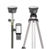
FJD Trion V10L RTK Rover Set with Laser Measurement
This product is available
Get the best price for your setup
Contact our experts for the best possible price and configuration.
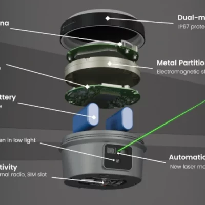
The FJD Trion V10L Rover Set is an RTK GNSS receiver for surveyors, construction teams, GIS workers and engineers who need accurate positioning with more flexibility in the field. It combines multi-constellation GNSS, a visible green laser, AR stakeout, dual cameras and 2nd-generation IMU tilt compensation to help measure and stake points that are hard, unsafe or time-consuming to reach with a pole.
FJD Trion V10L Highlights
| Laser Measurement | Class 2M green laser, 0–80 m measuring range |
|---|---|
| RTK Accuracy | H: 8 mm + 1 ppm RMS / V: 15 mm + 1 ppm RMS |
| IMU Tilt Compensation | 0–60° tilt, calibration-free 2nd-generation IMU |
| Visual Stakeout | AR guidance with dual 2 MP cameras |
| GNSS Channels | 1408 channels with GPS, GLONASS, BeiDou, Galileo, QZSS, IRNSS and SBAS support |


Valued customers:


Find RTK Networks
Search NTRIP providers and connect to reliable RTK correction services.
Description
FJD Trion V10L Rover Set RTK GNSS Receiver with Laser Measurement
The FJD Trion V10L Rover Set is built for field teams that need accurate RTK positioning but do not always have the perfect place to put a survey pole. It is a practical GNSS rover for construction layout, topographic survey, engineering work, GIS mapping, infrastructure inspection and general site measurement where speed, safety and flexibility matter.
Instead of relying only on standard pole-based measurements, the V10L adds laser measurement and visual workflows to the GNSS rover. This helps when a point is behind a fence, on a wall corner, near traffic, along a riverbank, under a bridge, close to an excavation edge or simply difficult to occupy safely. The operator can aim, measure and stake out from a distance while still working within a familiar RTK survey workflow.
Laser measurement for hard-to-reach points
The visible green laser is one of the main reasons to choose the FJD Trion V10L. It allows non-contact measurement, so the user does not always need to stand directly on the point. In everyday fieldwork, this can save time and reduce risk when measuring building corners, bridge structures, underpasses, slopes, water edges and busy construction zones.
The laser is designed to remain visible in bright daylight and low-light conditions, while the integrated camera view helps the user aim and confirm the target. For construction crews and surveyors, this makes the V10L especially useful when a normal GNSS pole setup would be slow, awkward or unsafe.
RTK GNSS performance for professional fieldwork
The FJD Trion V10L uses a 1408-channel GNSS board with support for major satellite constellations including GPS, GLONASS, BeiDou, Galileo, QZSS, IRNSS and SBAS. This gives field crews strong satellite availability across different working environments, from open construction sites to roads, utility corridors and infrastructure projects.
With RTK accuracy specified at 8 mm + 1 ppm horizontal and 15 mm + 1 ppm vertical, the V10L is suitable for demanding survey and layout tasks where centimetre-level positioning is required. It can be used for point collection, stakeout, as-built checks, control work, GIS data capture and site layout when connected to suitable correction services or a compatible base setup.
IMU tilt compensation for faster measuring
The 2nd-generation IMU allows measurements with the pole tilted up to 60°. This is useful when the operator cannot hold the pole perfectly vertical, for example near obstacles, walls, fences, trenches, traffic barriers or vegetation. Instead of spending extra time levelling the bubble for every point, the user can keep working more naturally while the system compensates for the pole angle.
For construction workers and survey crews, this means fewer interruptions and faster point collection. It also makes the rover easier to use for less experienced operators who still need reliable results in real jobsite conditions.
AR stakeout and visual guidance
The V10L supports visual stakeout using dual 2 MP cameras and AR guidance. Rather than relying only on map arrows or distance values, the operator can use a live camera view to see where the target point is located in the real scene. This is helpful for placing stakes, checking design points, locating utilities and guiding crews on busy sites.
AR stakeout is especially useful when moving between many points. It helps the operator understand direction and distance more quickly, reducing unnecessary walking and making the workflow easier for teams that need clear visual guidance in the field.
Built for survey, construction, GIS and infrastructure work
The FJD Trion V10L Rover Set is suitable for a wide range of users. Surveyors can use it for RTK point measurement, stakeout and topographic work. Construction professionals can use it for layout, checking positions and measuring difficult points around structures. GIS teams can capture accurate field data, while drone pilots and mapping specialists can use it to support ground control and site verification workflows.
Typical applications include building corners, bridge areas, road projects, utility corridors, substations, riverbanks, underpasses, earthworks and general site measurement. The combination of GNSS, laser, cameras and IMU tilt compensation gives crews more options when site conditions are not ideal.
Connectivity for modern RTK workflows
The V10L includes several communication options for different field setups. It supports 4G, Wi-Fi, NFC and UHF radio, making it suitable for network RTK, base-rover workflows and connected survey projects. The receiver also includes internal memory and common data communication support for professional field use.
This flexibility is important for teams working across multiple sites, countries or correction service environments. Whether the job uses an NTRIP correction service or a local base station, the V10L is designed to fit into practical RTK workflows.
Field-ready design
The receiver is designed for outdoor work with IP68 protection, a durable housing and a battery life of up to 15 hours in rover mode under standard operating conditions. At approximately 980 g, it remains manageable for daily pole work while still offering advanced laser and visual functions.
The compact OLED screen, physical buttons and controller options make the system practical for crews who need equipment that can be used efficiently on site, not just in perfect office demonstrations.
Why buy from Global GPS Systems
Global GPS Systems supplies professional GNSS equipment to surveyors, engineers, construction companies, GIS users and mapping professionals worldwide. When choosing a laser RTK rover like the FJD Trion V10L, having the right advice and support is important. Global GPS Systems can help buyers compare rover options, understand correction workflows and select a setup that fits their fieldwork.
The FJD Trion V10L Rover Set is a strong choice for users who want a modern RTK GNSS receiver with laser measurement, visual stakeout and IMU tilt compensation in one field-ready system.
Datasheets & Manuals
Datasheets and manuals
Datasheet
Specifications
FJD Trion V10L Rover Set Specifications
Product Overview
| Product name | FJD Trion V10L Rover Set |
|---|---|
| Product type | RTK GNSS rover set with laser measurement and visual stakeout |
| Primary use | High-accuracy GNSS surveying, construction layout, mapping, GIS data collection, engineering and infrastructure fieldwork |
| Main technologies | Multi-constellation GNSS, RTK positioning, 2nd-generation IMU tilt compensation, visible green laser, dual cameras, AR stakeout, 4G, Wi-Fi, Bluetooth, NFC and UHF radio |
| Typical users | Surveyors, construction teams, civil engineers, GIS users, mapping professionals, utility teams and infrastructure crews |
| Typical applications | Topographic survey, construction stakeout, cadastral work, road and bridge projects, utility mapping, GIS collection, earthworks, mining, water engineering, power and energy projects, as-built documentation and hard-to-reach point measurement |
| Hard-to-reach scenarios | Wall corners, substations, bridges, riverbanks, underpasses, excavation edges and areas where direct pole occupation is difficult or unsafe |
Key Features
| Non-contact laser measurement | Measures points without placing the pole directly on the target |
|---|---|
| Visible green laser | Class 2M green laser designed for easier aiming in bright sunlight and low-light conditions |
| EasyFix feature | Uses live camera view with auto-alignment and auto-zoom algorithms to help lock onto targets |
| AR stakeout | Real-scene augmented reality stakeout with direction and distance guidance on screen |
| Visual stakeout | Uses dual 2 MP cameras and automatically switches between front and bottom views for stakeout guidance |
| 2nd-generation IMU | Calibration-free IMU with faster startup and 0–60° tilt compensation |
| Field controller compatibility | Can be used with a compact keyboard controller or tablet controller running the Trion Survey app |
| Configuration options | V10La standard version; V10Li adds visual measurement functionality |
GNSS Tracking
| GNSS channels | 1408 channels |
|---|---|
| GPS | L1A, L1C, L2C, L2P, L5 |
| GLONASS | L1, L2, L3 |
| BeiDou | B1I, B2I, B3I, B1C, B2a, B2b |
| Galileo | E1, E5a, E5b, E6 |
| QZSS | L1, L2C, L5, L6* |
| IRNSS | L5* |
| SBAS | L1C/A |
| HAS-PPP | E6 |
| Firmware-dependent signals | *QZSS L6 and IRNSS L5 support by firmware upgrade |
Positioning Performance
| RTK accuracy | Horizontal: 8 mm + 1 ppm RMS; Vertical: 15 mm + 1 ppm RMS |
|---|---|
| RTK initialization time | <5 s |
| RTK initialization reliability | >99.9% |
| Post-processing static accuracy | Horizontal: 2.5 mm + 0.5 ppm RMS; Vertical: 5 mm + 0.5 ppm RMS |
| High-precision static accuracy | Horizontal: 2.5 mm + 0.1 ppm RMS; Vertical: 3.5 mm + 0.4 ppm RMS |
| PPK accuracy | Horizontal: 3 mm + 1 ppm RMS; Vertical: 5 mm + 1 ppm RMS |
| PPP accuracy | Horizontal: ±20 cm RMS; Vertical: ±40 cm RMS |
| Code differential accuracy | Horizontal: 0.4 m RMS; Vertical: 0.8 m RMS |
| Autonomous accuracy | Horizontal: 1.5 m RMS; Vertical: 2.5 m RMS |
| SBAS accuracy | 60 cm |
| Positioning rate | 1 Hz, 2 Hz, 5 Hz and 10 Hz |
| Visual survey accuracy | Typically 3 cm, range 2–15 m; V10Li supported |
| Tilt angle | 0–60° |
| RTK accuracy with tilt compensation | RMS: 8 mm + 0.6 mm/° tilt |
| Cold start | <20 s |
| Warm start | <5 s |
| Signal re-acquisition | <1 s |
Laser Measurement
| Laser type | Class 2M green laser |
|---|---|
| Laser wavelength | 520 nm ±20 nm |
| Measuring range | 0–80 m |
| Ranging accuracy | ±(5 + 100 × 10⁻⁶ × D) mm, where D is measuring distance in mm |
| Laser measurement accuracy within 5 m | ≤2 cm |
| Laser measurement accuracy within 10 m | ≤3 cm |
| Laser measurement accuracy within 15 m | ≤4 cm |
| Non-contact measurement range noted in brochure | 15 m range with ±4 cm precision; Automatic Gain Control supports measurements up to 80 m depending on conditions |
| Laser stakeout | AR laser stakeout with one-click laser guidance |
Camera and Visual Measurement
| Camera system | Dual 2 MP cameras |
|---|---|
| Field of view | 88° |
| Visual layout | Vertical field of view: 63°; Horizontal field of view: 76° |
| Image group capture method | Video photogrammetry |
| Maximum image group capture time | 30 s |
| Approximate image group size | Approximately 30 MB |
| Night vision / illumination | Starlight-grade camera with global shutter and large-format 3 µm × 3 µm sensor |
| Low-light imaging | Maintains full color at low illumination levels |
| Visual measurement | V10Li version supports selecting multiple points from a single image |
| Visual stakeout views | Front and bottom camera views with automatic switching |
Communications and Connectivity
| SIM card type | Nano-SIM card |
|---|---|
| Cellular modem | Integrated 4G modem |
| Supported cellular networks | TDD-LTE, FDD-LTE, WCDMA, EDGE, GPRS, GSM |
| Wi-Fi | 2.4 GHz and 5 GHz, 802.11a/b/g/n/ac |
| Bluetooth | 2.1 EDR, 3.0 HS, 4.2 LE, 5.0 LE |
| NFC | NFC for device pairing |
| Physical ports | 7-pin LEMO port, UHF antenna port, USB Type-C port |
| Built-in UHF radio frequency | Rx/Tx: 410–470 MHz / 902–928 MHz |
| Built-in UHF transmit power | 2 W |
| UHF protocols | TRIMTALK, TRIMMARK III, TT450S, TRANSEOT, Satel 3AS 4FSK, LoRa |
| UHF link rate | 9,600 bps to 19,200 bps |
| UHF range | Typical 6–12 km; up to 16 km under optimal conditions |
| Correction / data output | NMEA-1083, RTCM3.X |
| Data input formats | RTCM2.X, CMR |
| Internal storage | 32 GB internal memory |
Power and Battery
| Battery type | Built-in Li-ion battery |
|---|---|
| Battery capacity | 7000 mAh, 7.4 V |
| Fast charging | 30 W PD fast charge |
| Operating time in rover mode | 15 h |
| Operating time in base mode | 10 h |
| Operating time in static mode | >25 h |
| External power input | 9–28 V DC |
| Power consumption, UHF/4G RTK rover without camera | Typical 3 W |
| Power consumption, visual stakeout / visual survey | Typical 4.5 W |
| Battery life note | Battery life depends on operation environment, working temperature and working mode |
Hardware and Durability
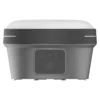
| Dimensions | Φ130 × 83 mm |
|---|---|
| Weight | Approximately 980 g |
| Display | 1.41-inch true color OLED screen, 320 × 360 resolution, 274 ppi |
| Front panel | 4 LED indicators and 2 physical buttons |
| Operating temperature | -35°C to 65°C |
| Storage temperature | -40°C to 70°C |
| Humidity | 95% non-condensing |
| Ingress protection | IP68, dustproof and protected from continuous immersion to a depth of 1 m |
| Drop resistance | Designed to survive a 2 m pole drop |
| Waterproof and breathable membrane | Helps prevent water vapor from entering under harsh environments |
| Tilt sensor | Immune to magnetic disturbances with e-bubble leveling |
Software and Workflow
| Field software | FJD Trion Survey app / software |
|---|---|
| Supported field workflows | Non-contact measurement, laser stakeout, AR stakeout, RTK survey, tilt survey, point collection and construction layout |
| Controller options | Compact keyboard controller or tablet controller |
| Connected workflow | Designed to work within the FJD Trion workflow for data collection, processing, deliverables and cloud sharing |
Model / Configuration Comparison
| Feature | V10La | V10Li |
|---|---|---|
| Positioning and laser measurement | Supported | Supported |
| Non-contact measurement | Supported | Supported |
| Laser stakeout | Supported | Supported |
| Visual measurement | Not listed as included | Supported |
| Visual survey accuracy | Configuration dependent | Typically 3 cm, range 2–15 m |
| Best suited for | Standard point-by-point measurement and laser stakeout | Jobs with many targets or complex scenes where multiple points can be selected from one image |
Rover Set / Included Items
| Item | Quantity | Notes |
|---|---|---|
| FJD Trion V10L GNSS receiver | 1 | Main RTK GNSS rover receiver with laser measurement |
| Data collector / field controller | Configuration dependent | Product listing shows a rover set with receiver, data collector, pole and bracket; controller type may vary |
| Survey pole | Configuration dependent | Included set contents may vary by selected configuration |
| Controller bracket / pole mount | Configuration dependent | Included set contents may vary by selected configuration |
| Software / app access | Configuration dependent | Designed for use with FJD Trion Survey app / software |
Specifications and package contents may vary by configuration, region or manufacturer update. Always check the current configuration before ordering.
FAQ
FJD Trion V10L Rover Set FAQ
Product Overview
What is the FJD Trion V10L Rover Set?
The FJD Trion V10L Rover Set is a professional RTK GNSS rover system with laser measurement, visual stakeout, dual cameras, 60° IMU tilt compensation, 4G connectivity, Wi-Fi, Bluetooth, NFC, and built-in UHF radio support. It is designed for accurate field positioning, surveying, mapping, and construction stakeout.
Who is the FJD Trion V10L designed for?
The FJD Trion V10L is designed for surveyors, construction layout teams, civil engineers, GIS users, mapping professionals, infrastructure contractors, utility crews, mining teams, earthworks contractors, and other field teams that need accurate GNSS positioning with flexible measurement options.
What makes the FJD Trion V10L different from a standard RTK GNSS rover?
The V10L combines standard RTK GNSS surveying with a visible green laser, non-contact measurement, AR visual stakeout, dual 2 MP cameras, and a second-generation IMU. This allows users to measure and stake out points that may be difficult, unsafe, or time-consuming to reach with a pole.
What industries can use the FJD Trion V10L?
The V10L is suitable for surveying, construction, civil engineering, road and bridge work, utility mapping, GIS data collection, cadastral work, mining, earthworks, water engineering, power and energy projects, and as-built documentation.
What is the difference between the FJD Trion V10La and V10Li?
The V10La supports non-contact laser measurement and laser stakeout for standard point-by-point work. The V10Li includes the same core capabilities and adds visual measurement, which allows multiple points to be selected from a single image and is useful for jobs with many targets or complex scenes.
Accuracy, Laser Measurement and Stakeout
How accurate is the FJD Trion V10L?
The specified RTK accuracy is H: 8 mm + 1 ppm RMS and V: 15 mm + 1 ppm RMS under suitable RTK conditions. With tilt compensation, the specified RTK accuracy is RMS: 8 mm + 0.6 mm per degree of tilt.
Can the FJD Trion V10L measure points without touching them?
Yes. The V10L supports non-contact laser measurement, allowing users to aim at and measure points from a distance without placing the pole directly on the target. This is useful for wall corners, bridge elements, riverbanks, underpasses, excavation edges, and other difficult or unsafe locations.
What is the laser measuring range of the FJD Trion V10L?
The V10L has a specified laser measuring range of 0 to 80 m. For practical high-accuracy laser measurement, the product specifications list laser measurement accuracy up to 15 m, with Automatic Gain Control helping adapt to light and surface conditions.
How accurate is the laser measurement?
The listed laser measurement accuracy is ≤2 cm within 5 m, ≤3 cm within 10 m, and ≤4 cm within 15 m. Actual field results can depend on conditions such as target surface, distance, visibility, correction quality, and setup.
Is the green laser visible in sunlight and low light?
Yes. The V10L uses a visible green laser designed to support aiming in bright sunlight and low-light conditions. It also includes a night-vision camera to support measurement and stakeout when visibility is reduced.
What is EasyFix on the FJD Trion V10L?
EasyFix helps users lock onto targets using the live camera view. Auto-alignment and auto-zoom support more precise target selection, especially when measuring or staking points from a distance.
What is AR visual stakeout?
AR visual stakeout shows direction and distance guidance on screen, helping users see where to move before they walk to the point. This can reduce back-and-forth movement and make stakeout easier on busy or complex sites.
GNSS, Connectivity and Software
Which GNSS constellations does the FJD Trion V10L support?
The V10L supports GPS, GLONASS, BeiDou, Galileo, QZSS, IRNSS, SBAS, and HAS-PPP signals as specified. It has 1408 GNSS channels for multi-constellation tracking.
Can the FJD Trion V10L be used with NTRIP corrections?
Yes. The receiver includes an integrated 4G modem and supports correction workflows through communication options such as 4G, Wi-Fi, radio, and other compatible field links when used with suitable software and correction services.
Does the FJD Trion V10L have a built-in UHF radio?
Yes. The V10L includes built-in UHF radio support with Rx/Tx frequency options of 410–470 MHz and 902–928 MHz, depending on regional configuration and local radio regulations.
What wireless connectivity options does the V10L support?
The V10L supports an integrated 4G modem, 2.4 GHz and 5 GHz Wi-Fi, Bluetooth, NFC device pairing, and UHF radio. This gives field crews multiple ways to connect to controllers, correction services, base stations, and data workflows.
What ports does the FJD Trion V10L have?
The V10L includes a 7-pin LEMO port, UHF antenna port, and USB Type-C port. These ports support field connectivity, data transfer, external accessories, and power-related workflows.
Does the FJD Trion V10L work with Trion Survey software?
Yes. The V10L is designed to work with the Trion Survey app for field measurement, non-contact operation, stakeout, and data collection workflows. It can be used with compatible controller options, including compact keyboard-style controllers or tablet controllers.
Field Use, Battery and Durability
Does the FJD Trion V10L support tilt measurement?
Yes. The V10L supports 0–60° IMU tilt compensation. This helps users measure points without keeping the pole perfectly vertical, which is useful near obstacles, walls, traffic, equipment, or rough terrain.
Does the IMU need calibration?
The V10L uses a second-generation IMU designed for calibration-free startup. This helps reduce setup time and allows crews to begin measuring more quickly in the field.
Is the FJD Trion V10L suitable for construction stakeout?
Yes. The V10L is well suited to construction stakeout because it combines RTK positioning, tilt compensation, AR visual stakeout, laser guidance, and non-contact measurement. It is useful for layout work on jobsites where direct access to every point is not always practical.
Where is non-contact measurement most useful?
Non-contact measurement is useful for hard-to-reach or potentially unsafe points, including wall corners, bridge structures, riverbanks, underpasses, substations, excavation edges, busy traffic areas, and construction zones with obstacles.
What is the operating time of the FJD Trion V10L?
The specified operating time on the internal battery is up to 15 hours in rover mode, 10 hours in base mode, and more than 25 hours in static mode. Actual battery life can vary depending on working mode, temperature, camera use, radio use, and field conditions.
Is the FJD Trion V10L waterproof and durable?
Yes. The V10L is rated IP68 for dust and water protection and is designed to survive a 2 m pole drop. It is built for demanding field environments such as construction sites, infrastructure projects, and outdoor surveying work.
What operating temperature range does the V10L support?
The specified operating temperature range is -35°C to 65°C, with a storage temperature range of -40°C to 70°C. This makes the receiver suitable for a wide range of outdoor surveying and construction environments.
Reviews (0)
Only logged in customers who have purchased this product may leave a review.
Reviews
There are no reviews yet