


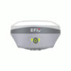
EFIX F8 Rover Set Vision IMU RTK GNSS Receiver
This product is available
Get the best price for your setup
Contact our experts for the best possible price and configuration.
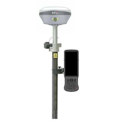
The EFIX F8 Rover Set is a compact vision IMU RTK GNSS solution for surveyors, construction teams, GIS users and field engineers who need fast, accurate positioning in practical site conditions. With 1608 channels, full GNSS constellation support, dual-camera vision survey, AR stakeout guidance and 60° IMU tilt compensation, the F8 helps you measure points faster, including locations that are difficult to reach with a levelled pole.
EFIX F8 Rover Set Highlights
| GNSS Channels | 1608 channels |
|---|---|
| Satellite Support | GPS, GLONASS, Galileo, BeiDou, QZSS and SBAS |
| IMU Tilt | 0–60° automatic IMU tilt compensation |
| Vision Survey | Dual-camera vision measurement and AR stakeout |
| UHF Radio | Integrated 410–470 MHz UHF radio |
Valued customers:


Find RTK Networks
Search NTRIP providers and connect to reliable RTK correction services.
Description
EFIX F8 Rover Set for Vision IMU RTK Surveying
The EFIX F8 Rover Set is built for professionals who need reliable RTK GNSS performance in everyday fieldwork. It combines a compact GNSS receiver, vision technology, automatic IMU tilt compensation and eField field software into a practical rover package for land surveying, construction layout, infrastructure work, GIS data collection and engineering measurements.
For surveyors and site teams, the main advantage of the EFIX F8 is that it helps reduce the time spent trying to reach or level difficult points. The receiver uses dual cameras for vision survey and visual stakeout workflows, allowing you to measure or navigate to points with real-time visual guidance. This is useful around fences, slopes, corners, stockpiles, traffic areas, trenches and other locations where conventional pole positioning can slow the job down.
Vision Survey and AR Stakeout for Faster Fieldwork
The EFIX F8 is designed around the idea of measuring what you see. Its front and bottom cameras support vision-based survey and stakeout tasks in eField software. Instead of relying only on map view or offset methods, field crews can use visual guidance to move towards stakeout points and capture measurements in more complex environments.
In construction and infrastructure work, this can make set-out tasks easier to understand for mixed teams. Operators can follow visual direction on the controller, while surveyors keep control over accuracy, point coding and project data. For GIS and asset mapping, the vision functions can also help when collecting features that are near obstacles or not comfortable to access directly.
60 Degree IMU Tilt Compensation
The built-in IMU allows measurements with the pole tilted up to 60 degrees. This helps when working beside walls, under light obstruction, on uneven ground or near objects where keeping the pole perfectly vertical is not practical. Tilt compensation reduces the need for repeated levelling and can speed up point collection during topographic surveys, boundary work, site checks and utility mapping.
The F8 uses automatic IMU operation, so the receiver is suited to busy field conditions where surveyors need to move quickly between points. In real use, this means less time adjusting the pole and more time collecting usable data.
Full Constellation GNSS Performance
With 1608 channels and support for GPS, GLONASS, Galileo, BeiDou, QZSS and SBAS, the EFIX F8 is made for professional RTK workflows where satellite availability matters. Full-constellation tracking helps maintain productivity in changing site conditions, including urban edges, tree-lined areas and construction sites with partial sky obstruction.
The receiver supports RTK accuracy for precise field positioning and includes UHF radio capability for rover-base workflows. It can also be used in network RTK workflows through the controller and field software, depending on your correction service and project setup.
Compact Receiver for Survey and Construction Crews
The EFIX F8 has a small, lightweight receiver body that is easy to handle during long field days. Its integrated battery system, USB Type-C charging and internal storage make it practical for teams that move between job sites and need a dependable GNSS rover without carrying unnecessary equipment.
The rover set includes the key accessories needed for a standard field setup, including the EFIX F8 GNSS receiver, UHF antenna, USB Type-C cable, tribrach adaptor, 2 m range pole with bag, auxiliary height tool and transport hard case. The set is commonly combined with an EFIX controller and eField software for a complete data collection workflow.
Who Uses the EFIX F8 Rover Set?
The EFIX F8 is suitable for land surveyors, construction layout teams, civil engineers, road and infrastructure contractors, GIS professionals, drone mapping teams and utility mapping crews. It is especially useful for users who need centimetre-level GNSS positioning but also want faster stakeout and measurement around obstacles.
Surveyors can use it for topographic surveys, control checks, boundary measurements, as-built surveys and stakeout. Construction professionals can use it for site layout, cut and fill checks, road work, machine control preparation and progress measurement. GIS teams can use it for accurate asset collection where handheld GPS accuracy is not enough.
Field Software and Workflow
The EFIX F8 Rover Set works with eField software, giving field teams tools for point measurement, stakeout, CAD-based workflows and road or surface-related tasks. The software is designed for practical field operation, so users can connect the receiver, manage jobs, collect points and export project data for office processing.
For buyers comparing RTK GNSS systems, the EFIX F8 is best suited to teams that want more than a standard IMU receiver. Its vision survey and AR stakeout functions add practical value when working in complex environments, while the full GNSS tracking and integrated UHF radio keep it flexible for different correction workflows.
Buying the EFIX F8 Rover Set from Global GPS Systems
Global GPS Systems supplies the EFIX F8 Rover Set for professional GNSS users worldwide. Our team can help you check whether this rover set fits your workflow, correction service, software preference and accuracy requirements. We also support customers with product advice, export knowledge and practical GNSS experience, so you can choose equipment that fits the way you actually work in the field.
Datasheets & Manuals
Datasheets and manuals
Specifications
EFIX F8 Rover Set Specifications
Product Overview
| Product Type | Professional GNSS RTK rover set |
|---|---|
| Receiver Model | EFIX F8 Vision IMU-RTK GNSS receiver |
| Primary Applications | Land surveying, construction layout, stakeout, topographic survey, mapping, earthworks, road work and 3D modeling workflows |
| Core Technologies | Full-constellation GNSS, RTK, 4D Auto-IMU tilt compensation, vision survey, AR vision navigation and vision stakeout |
| GNSS Channels | 1608 channels |
| Integrated Cellular Modem | None in the F8 receiver; mobile internet can be used through the included controller or external data connection where configured |
GNSS Signal Tracking
| GPS | L1C/A, L2C, L2P(Y), L5 |
|---|---|
| GLONASS | L1, L2, L3 |
| Galileo | E1, E5a, E5b, E6 |
| BeiDou | B1I, B2I, B3I, B1C, B2a, B2b |
| QZSS | L1, L2, L5, L6 |
| SBAS | L1, L2 |
| PPP | B2b-PPP |
| RTK Engine | Full-Star algorithm for full-constellation and multi-frequency tracking |
Positioning Accuracy
| Mode | Horizontal Accuracy | Vertical Accuracy / Notes |
|---|---|---|
| Real-Time Kinematic (RTK) | 8 mm + 1 ppm RMS | 15 mm + 1 ppm RMS; initialization time < 10 s; initialization reliability > 99.9% |
| Post-Processing Kinematic (PPK) | 3 mm + 1 ppm RMS | 5 mm + 1 ppm RMS |
| Post-Processing Static | 2.5 mm + 0.5 ppm RMS | 5 mm + 0.5 ppm RMS |
| Code Differential | 0.4 m RMS | 0.8 m RMS |
| Autonomous | 1.5 m RMS | 2.5 m RMS |
| Vision Survey | Typical 2–4 cm | Measurement range 2–10 m |
| Positioning Rate | 1 Hz, 5 Hz and 10 Hz | Selectable positioning output rates |
| Time to First Fix | Cold start: < 45 s; hot start: < 10 s | Signal reacquisition: < 1 s |
IMU Tilt Compensation
| IMU Type | 4D Auto-IMU |
|---|---|
| IMU Update Rate | 200 Hz |
| Tilt Angle Range | 0° to 60° |
| Pole-Tilt Compensation | Calibration-free IMU pole-tilt compensation |
| Additional Horizontal Pole-Tilt Accuracy | Typically less than 2.5 cm within 30° |
| Magnetic Immunity | Designed to be immune to magnetic disturbance |
| IMU Workflow | Automatic 4D IMU initialization during motion with continuous field operation support |
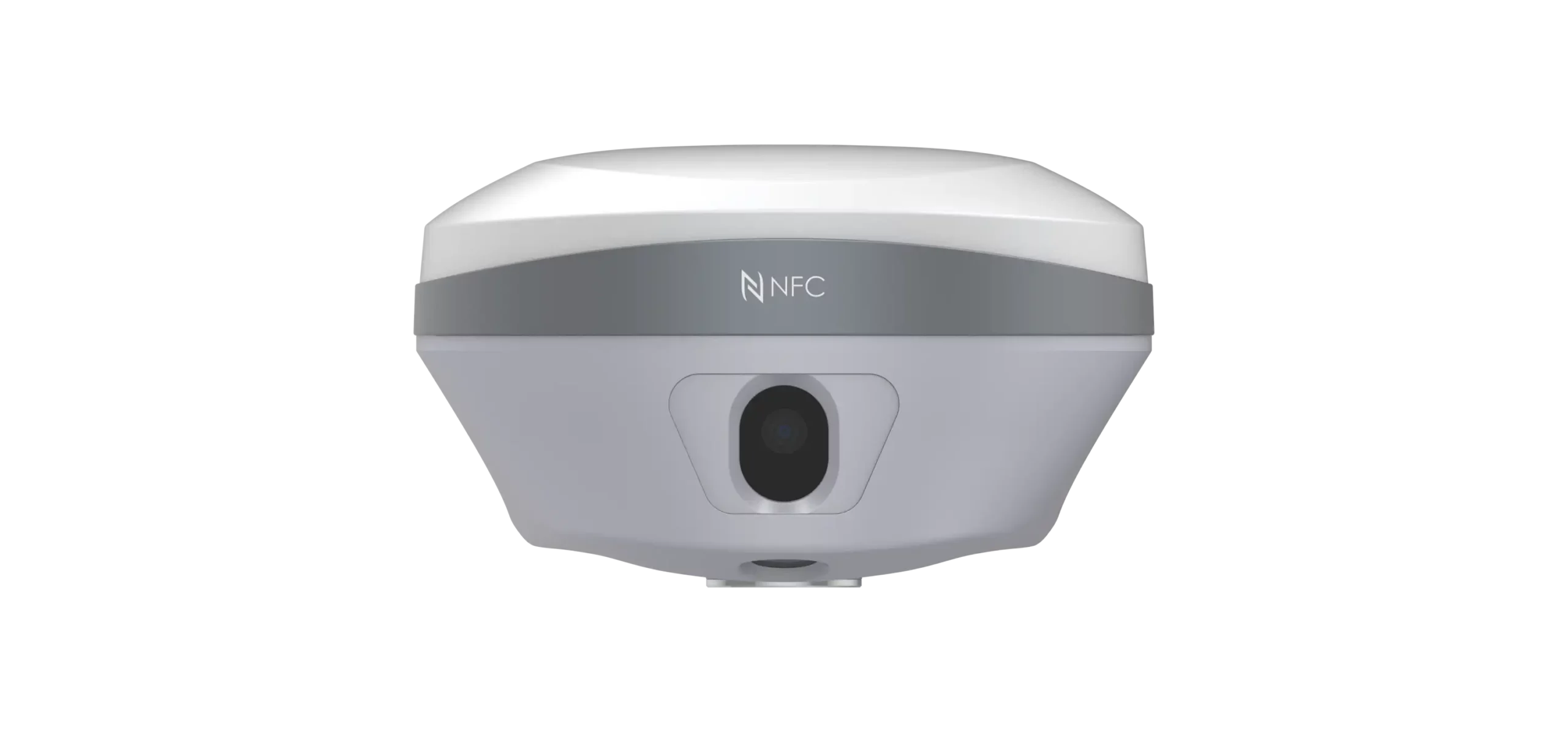
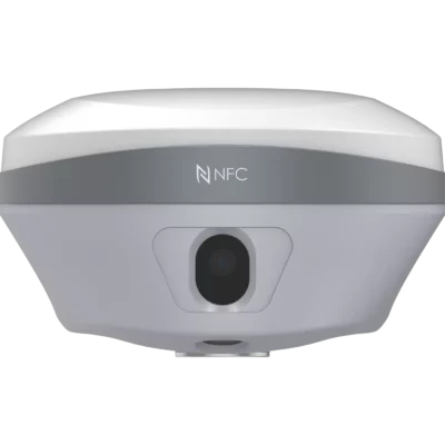
Vision Camera and Imaging
| Vision System | Integrated vision system for AR navigation, vision stakeout, vision survey and 3D modeling workflows |
|---|---|
| Camera Sensor | 2 MP |
| Field of View | 75° |
| Video Frame Rate | 25 fps |
| Image Group Capture | Typical 2 Hz capturing rate; up to 25 Hz maximum |
| Maximum Capture Time | 60 s |
| Approximate Image Group Size | Approximately 60 MB |
| Vision Survey Function | Measures high-precision 3D coordinates from real-time video for signal-obscured, hard-to-reach and hazardous points |
| 3D Modeling Function | Captures POS photos for building modeling and collaborative modeling workflows |
Communication and Radio
| Wi-Fi | 802.11 b/g/n/ac, access point mode |
|---|---|
| Bluetooth | Bluetooth v4.2 |
| NFC | Supported |
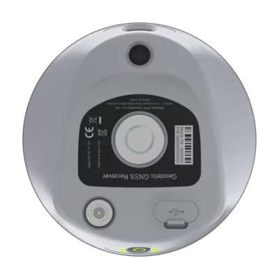
| USB Port | 1 x USB Type-C port for external power, data download and firmware update |
| UHF Antenna Port | 1 x UHF antenna port, TNC female |
| Internal UHF Radio | Standard internal Tx/Rx, 410–470 MHz |
| UHF Transmit Power | 0.5 W or 1 W |
| UHF Protocols | EFIX, Transparent, TT450, Satel |
| UHF Link Rate | 9,600 bps to 19,200 bps |
| UHF Range | Typical 3 km; up to 8 km under optimal conditions |
Data Formats and Storage
| Correction Formats | RTCM2.x, RTCM3.x, CMR input/output |
|---|---|
| Static and Raw Data Formats | Full-Star RINEX 2.11, 3.02, HCN, HRC and RINEX static formats |
| Navigation Output | NMEA 0183 output |
| NTRIP | NTRIP client and NTRIP caster |
| Internal Data Storage | 8 GB high-speed memory |
| Data Download | USB Type-C, FTP download and web server download supported through receiver workflow |
Power and Battery
| Specification | Value | Notes |
|---|---|---|
| Power Consumption | Typical 2.2 W | Dependent on user settings |
| Battery Type | Rechargeable built-in lithium battery | Receiver battery system |
| Battery Capacity | 4900 mAh, 7.2 V | Manufacturer datasheet value |
| RTK Rover Runtime Without Camera | Up to 16.5 h | UHF/4G mode without camera |
| Vision Stakeout / Vision Survey Runtime | Up to 9.5 h | RTK rover vision operation |
| UHF RTK Base Runtime | Up to 10 h | Base station mode |
| Static Survey Runtime | Up to 22 h | Static operation |
| External Power Input | 5 V / 2 A | Via USB Type-C |
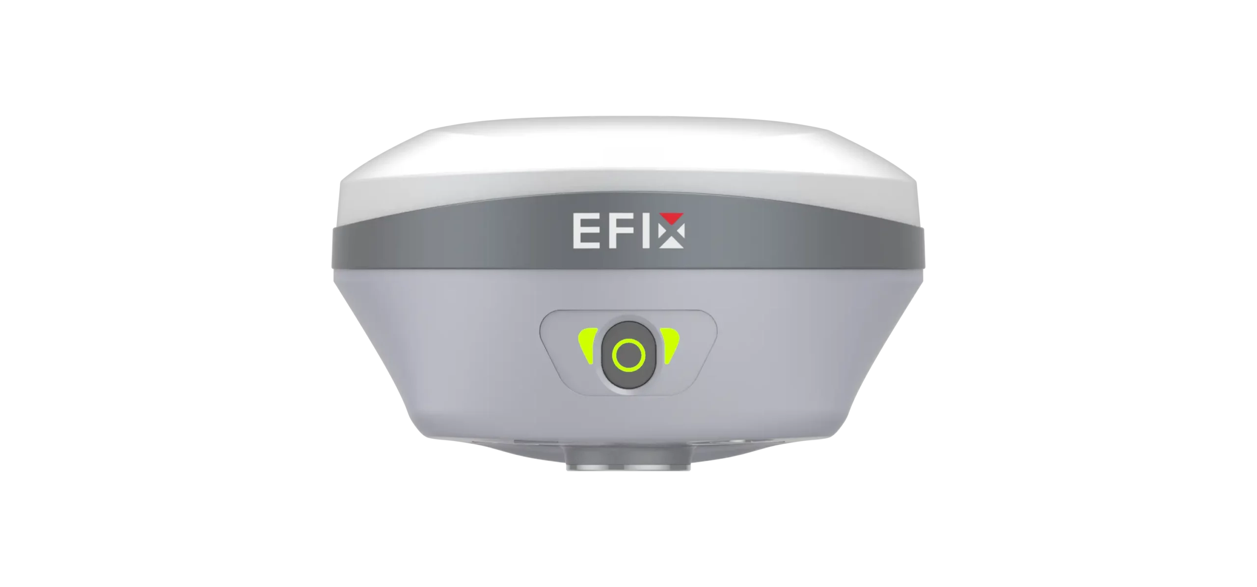
Receiver Physical and Environmental Specifications
| Dimensions | Φ134 mm x 80 mm; Φ5.28 in x 3.15 in |
|---|---|
| Weight | 750 g; 1.65 lb |
| Front Panel | 1 LED and 1 button |
| Operating Temperature | -40 °C to +65 °C; -40 °F to +149 °F |
| Storage Temperature | -40 °C to +85 °C; -40 °F to +185 °F |
| Humidity | 100% non-condensation |
| Ingress Protection | IP67 waterproof and dustproof; protected from temporary immersion to 1 m depth |
| Shock Resistance Grade | IK08 |
| Drop Resistance | Survives a 2 m pole drop |
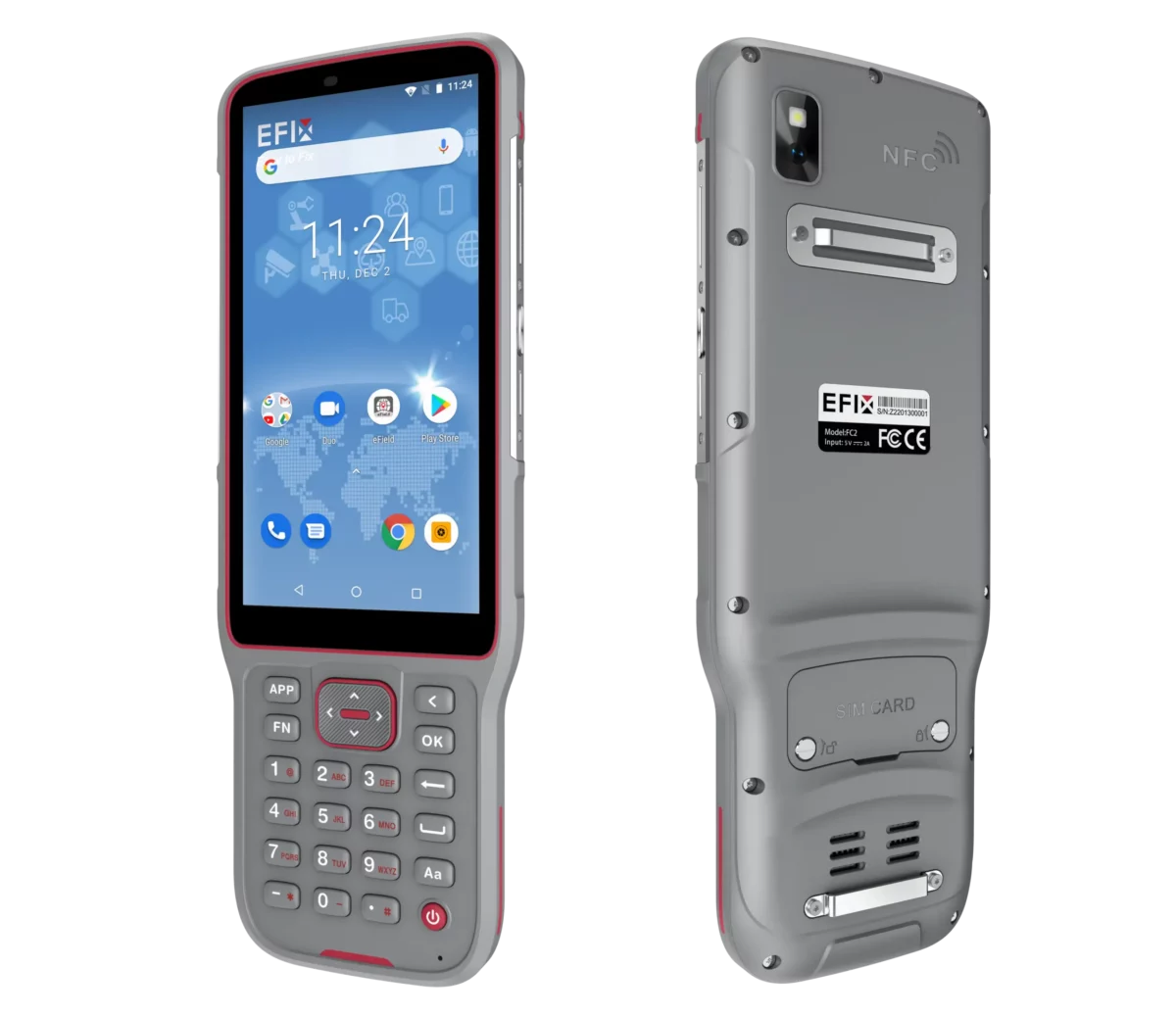
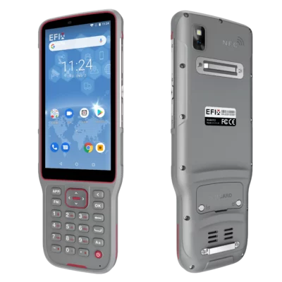
Included FC2 Data Collector
| Controller Model | EFIX FC2 handheld data controller |
|---|---|
| Operating System | Android 8.1 |
| Processor | MediaTek MTK6762 Octa Core 2.0 GHz |
| RAM | 4 GB |
| Internal Storage | 64 GB |
| Expandable Storage | MicroSD card, up to 128 GB |
| Display | 5.5 in IPS LTPS LCD capacitive multi-touch screen, HD 1440 x 720, 296 ppi scratch-resistant glass |
| Keypad | Alphanumeric keypad |
| Camera | 13 MP rear camera with auto-focus and flashlight |
| Mobile Network | 2G / 3G / 4G mobile network support |
| Wi-Fi | 802.11 a/b/g/n/ac/d/e/h/i/k/r/v/w |
| Bluetooth | Bluetooth v5.0 |
| USB | USB Type-C with OTG |
| Sensors | G-sensor, light sensor, NFC, gyroscope, e-compass and speaker |
| Battery Capacity | 6,500 mAh Li-ion battery |
| Operating Time | Up to 14 h under normal conditions |
| Charging Time | 4 h typical |
| Ingress Protection | IP67 |
| Drop Resistance | 2 m fall onto concrete |
| Controller Dimensions | 225 mm x 80 mm x 17 mm; 8.9 in x 3.2 in x 0.79 in |
| Controller Weight | 375 g; 13.2 oz with battery |
| Operating Temperature | -20 °C to +55 °C; -4 °F to +131 °F |
| Storage Temperature | -40 °C to +70 °C; -40 °F to +158 °F |
| Controller Certifications | CE, FCC, MIL-STD-810H, RoHS, WPC |
Software and Field Workflows
| Included Field Software | eField surveying software |
|---|---|
| Supported Survey Objects | Points, lines, polylines and surfaces |
| Survey Functions | Topographic survey, stakeout, road work, earthworks and related field surveying tasks |
| CAD and Mapping Functions | Features, codes, on-site drawing and CAD-related field functions |
| AR Vision Navigation | Visual navigation with real-time distance indication for field stakeout guidance |
| Vision Stakeout | Displays ground stakeout points in the field software for faster visual guidance |
| Road and Earthwork Support | Supports road stakeout workflows, cut-fill value workflows and LandXML-based road data workflows where configured |
Package / Included Items
| Item | Quantity | Notes |
|---|---|---|
| EFIX F8 GNSS receiver | 1 | Main Vision IMU-RTK rover receiver |
| EFIX FC2 data collector | 1 | Included handheld controller for field operation |
| eField surveying software | 1 | Field data collection and survey software |
| UHF bar / whip antenna | 1 | 410–470 MHz radio antenna |
| Telescopic / 2 m range pole with bag | 1 | Survey pole for rover operation |
| Data collector bracket | 1 | Mounting bracket for controller use in the field |
| eField USB Type-C cable | 1 | For charging, data download or receiver connection tasks |
| Tribrach adaptor | 1 | Included in the F8 basic supply accessories |
| Auxiliary H.I. tool | 1 | Height measurement accessory |
| Power adapter | 1 | Charging accessory |
| Transport hard case | 1 | Protective transport and storage case |
Specifications and package contents may vary by configuration, region or manufacturer update. Always check the current configuration before ordering.
FAQ
EFIX F8 Rover Set FAQ
Product Use and Applications
What is the EFIX F8 Rover Set used for?
The EFIX F8 Rover Set is used for professional RTK GNSS surveying, construction layout, stakeout, topographic measurement, roadwork, site mapping and engineering field tasks where accurate positioning is required.
Who is the EFIX F8 Rover Set designed for?
It is designed for land surveyors, construction layout teams, civil engineers, infrastructure contractors, road survey crews, mapping professionals and other users who need precise GNSS measurements in the field.
Can the EFIX F8 be used for construction stakeout?
Yes. The EFIX F8 is suitable for construction stakeout and layout work. Its RTK positioning, IMU tilt compensation and AR vision stakeout help users locate design points more quickly and accurately on site.
Is the EFIX F8 suitable for difficult terrain?
Yes. The EFIX F8 is built for demanding field conditions such as uneven ground, complex sites, hard-to-reach points and areas where traditional pole positioning can be difficult.
Can the EFIX F8 measure hard-to-reach or hazardous points?
Yes. The vision survey functions help users measure points that may be difficult, unsafe or inconvenient to access directly, reducing the need to physically place the pole on every point.
Accuracy, GNSS and RTK Performance
What RTK accuracy does the EFIX F8 provide?
The EFIX F8 offers RTK accuracy of 8 mm + 1 ppm RMS horizontally and 15 mm + 1 ppm RMS vertically under suitable field and correction conditions.
How many GNSS channels does the EFIX F8 have?
The EFIX F8 has 1608 GNSS channels, allowing it to track multiple satellite signals and frequencies for reliable positioning performance.
Which satellite constellations does the EFIX F8 support?
The EFIX F8 supports GPS, GLONASS, Galileo, BeiDou, QZSS, SBAS and PPP signals, depending on signal availability and local operating conditions.
How fast does the EFIX F8 initialize in RTK?
The EFIX F8 has an RTK initialization time of less than 10 seconds under suitable conditions, with initialization reliability listed as greater than 99.9%.
Does the EFIX F8 support static and post-processing surveys?
Yes. The EFIX F8 can log static GNSS data and supports post-processing workflows, including RINEX format options for office processing.
Does the EFIX F8 have a built-in UHF radio?
Yes. The EFIX F8 includes a UHF radio operating in the 410–470 MHz range, making it suitable for rover workflows that use radio corrections from a compatible base station.
IMU, Vision Survey and AR Stakeout
Does the EFIX F8 have IMU tilt compensation?
Yes. The EFIX F8 includes a 4D Auto-IMU with tilt compensation up to 60 degrees, helping users measure points without keeping the pole perfectly vertical.
Does the EFIX F8 IMU need calibration?
The EFIX F8 uses calibration-free IMU pole-tilt compensation, helping reduce setup time and keeping field workflows more efficient.
How does IMU tilt compensation help surveyors?
IMU tilt compensation helps users collect accurate points faster on slopes, near obstacles, beside walls or in other locations where leveling the pole is slow or difficult.
What is Vision Survey on the EFIX F8?
Vision Survey allows the EFIX F8 to use camera-based measurement to help capture high-precision 3D coordinates from complex scenes, including points that are difficult to access directly.
What does AR vision navigation do?
AR vision navigation provides visual guidance on the data collector screen, helping users navigate to points and perform stakeout with clearer real-time direction in the field.
How does AR vision stakeout improve field work?
AR vision stakeout displays visual guidance for ground points, making stakeout more intuitive and reducing the need for complex offset methods in many field situations.
Can the EFIX F8 be used for 3D modelling workflows?
Yes. The EFIX F8 can capture position photos through its Vision Survey workflow and can support field-to-office 3D modelling workflows when used with compatible software.
Hardware, Software and Included Set
What is included in the EFIX F8 Rover Set?
The EFIX F8 Rover Set includes the EFIX F8 receiver, EFIX FC2 data collector, eField surveying software, telescopic surveying pole and data collector bracket.
Does the EFIX F8 Rover Set include surveying software?
Yes. The set includes eField surveying software, which is used for GNSS data collection, stakeout and field measurement workflows.
Can the EFIX F8 Rover Set be customized with different accessories?
Yes. The rover set can be adapted with different accessories depending on the required workflow, such as alternative controllers, tablets or software options where compatible.
Is the EFIX F8 waterproof and dustproof?
Yes. The EFIX F8 has an IP67 protection rating, meaning it is protected against dust and water exposure for demanding outdoor surveying conditions.
How long does the EFIX F8 battery last?
Battery life depends on the operating mode and field conditions. The internal battery can operate up to 16.5 hours in RTK rover mode without camera use, up to 10 hours in UHF RTK base mode and up to 9.5 hours during vision stakeout or vision survey.
How much does the EFIX F8 receiver weigh?
The EFIX F8 receiver weighs approximately 750 g, making it a compact and lightweight GNSS rover for daily field use.
Does the EFIX F8 have internal storage?
Yes. The EFIX F8 includes 8 GB of high-speed internal memory for storing survey and GNSS data.
Reviews (0)
Only logged in customers who have purchased this product may leave a review.
Reviews
There are no reviews yet