

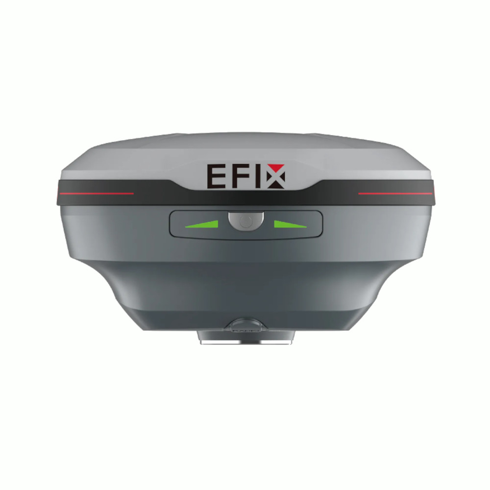


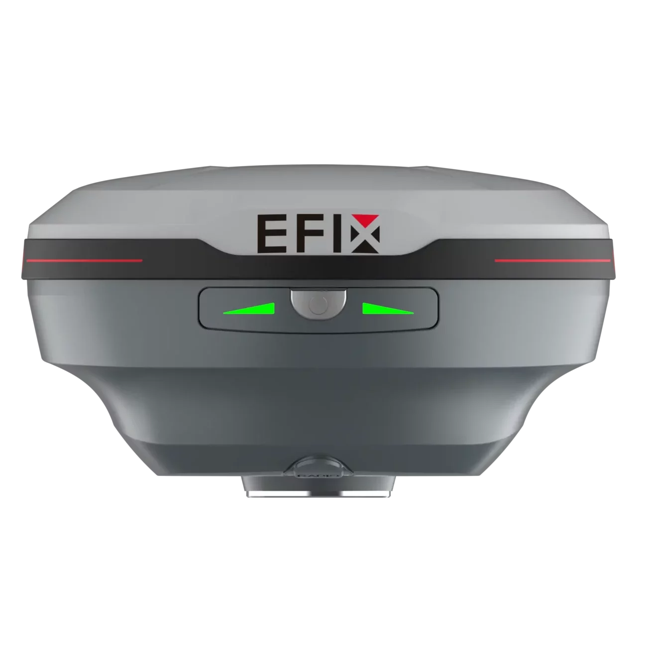


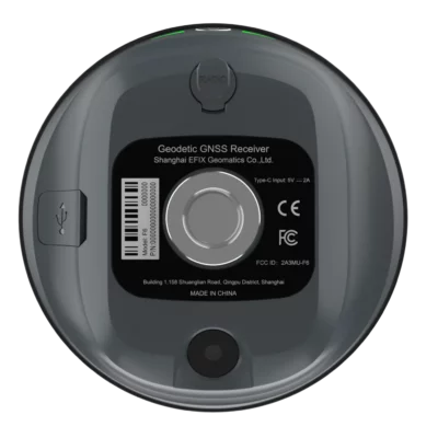


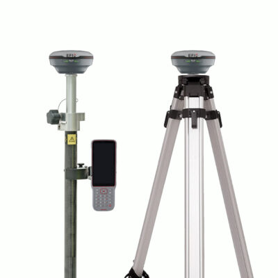
EFIX F6 Vision IMU RTK GNSS Receiver
This product is Available
Contact our experts for the best possible price and configuration.
The EFIX F6 is a compact Vision IMU RTK GNSS receiver for surveyors, construction teams, GIS users and field engineers who need accurate positioning in a lightweight setup. With 1608 GNSS channels, AR vision stakeout and 4D AUTO-IMU tilt compensation, it helps make measuring and staking out faster, clearer and easier on busy job sites.
EFIX F6 Highlights
| GNSS Channels | 1608 channels with GPS, GLONASS, Galileo, BeiDou, QZSS, NavIC and SBAS support |
|---|---|
| Vision Stakeout | 2 MP camera with AR visual guidance in eField software |
| IMU Tilt | 4D AUTO-IMU with tilt compensation up to 60° |
| RTK Accuracy | 8 mm + 1 ppm horizontal and 15 mm + 1 ppm vertical |
| Field Design | 450 g lightweight housing with IP68 protection and IK08 shock resistance |
Valued customers:


Find RTK Networks
Search NTRIP providers and connect to reliable RTK correction services.
Description
EFIX F6 Vision IMU RTK GNSS Receiver
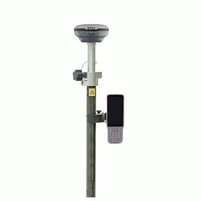
The EFIX F6 is a lightweight RTK GNSS receiver built for practical fieldwork in surveying, construction layout, mapping and engineering projects. It combines multi-constellation GNSS tracking, visual stakeout and automatic IMU tilt compensation in a compact 450 g receiver that is easy to carry, mount and use throughout the working day.
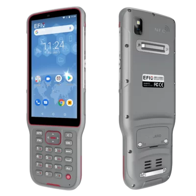
For surveyors and construction professionals, the EFIX F6 is especially useful when points need to be measured or staked out quickly in real site conditions. Instead of relying only on map views and direction values, the receiver works with eField software to show AR visual guidance through its built-in camera. This makes stakeout easier to understand for experienced surveyors, junior field crews and construction workers who need clear guidance on where to move the pole.
Designed for everyday RTK fieldwork
The EFIX F6 uses a 1608-channel GNSS engine with support for major satellite constellations including GPS, GLONASS, Galileo, BeiDou, QZSS, NavIC and SBAS. In the field, this means the receiver has more available signals to work with when you are surveying near buildings, trees, earthworks, road corridors or other areas where satellite visibility can change during the day.
With RTK accuracy of 8 mm + 1 ppm horizontally and 15 mm + 1 ppm vertically, the EFIX F6 is suitable for common professional tasks such as topographic surveys, boundary work, machine control preparation, construction set-out, as-built checks, road projects and utility mapping. It can also be used for static and PPK workflows when post-processing is required.
AR vision stakeout for clearer point layout
One of the main advantages of the EFIX F6 is its integrated vision stakeout function. The 2 MP camera supports real-time AR guidance in eField, helping the user see the direction to the point directly in the field view. For construction layout and staking work, this can reduce confusion and make it easier to move quickly from point to point.
This is helpful for teams that work with CAD drawings, design points, linework or road alignments. Instead of constantly interpreting numbers on a screen, the operator receives a more visual indication of where the stakeout point is located. This makes the EFIX F6 a strong choice for contractors, survey companies and engineering teams that want a more intuitive RTK rover for daily site work.
4D AUTO IMU tilt compensation
The EFIX F6 includes 4D AUTO-IMU tilt compensation up to 60°. This allows the survey pole to be tilted while still measuring accurate points, which is useful when the point is close to a wall, fence, trench, vehicle, stockpile, kerb or other obstacle. The IMU initializes automatically during movement, so users do not need a complicated calibration routine before starting work.
For field crews, this saves time and reduces awkward setups. You can measure difficult points without always having to hold the pole perfectly vertical, while the 200 Hz IMU update rate helps keep movement smooth and responsive during data collection.
Compact and durable for site conditions
At only 450 g, the EFIX F6 is much lighter than many traditional GNSS receivers. This makes a noticeable difference during long survey days, especially when walking large sites, carrying extra equipment or working in difficult terrain. The palm-size design is easy to transport and fits well into a modern rover setup.
The receiver is built for outdoor use with IP68 ingress protection, IK08 shock resistance and a housing designed to survive a 2 metre pole drop. This makes it suitable for construction sites, road projects, land surveying, earthworks, municipal work, agriculture mapping and other field environments where equipment needs to handle dust, rain and regular movement.
Long battery life and flexible connectivity
The EFIX F6 supports up to 17 hours of operation in UHF or 4G RTK rover mode without the camera, up to 10 hours during vision stakeout and up to 22 hours in static mode. Charging is handled through USB Type-C, and the receiver can be fully charged in around 4.5 hours. Power bank support is useful for longer days away from the office or vehicle.
For communication and data workflows, the EFIX F6 supports Bluetooth, Wi-Fi, NFC touch pairing, USB Type-C data transfer, NTRIP client and caster functions, common RTCM correction formats, NMEA output and RINEX data storage. This gives surveyors and GIS teams the flexibility to work with network RTK, base-rover setups, static observations and standard field data workflows.
Works with eField software
The EFIX F6 is designed to work with EFIX eField software for surveying, stakeout and field data collection. Users can perform map surveys, CAD stakeout, CAD editing and earthwork volume calculations directly in the field. For construction and surveying teams, this helps reduce the amount of back-office preparation and makes it easier to react to changes on site.
CAD stakeout is particularly useful for contractors and engineers who need to set out points and lines from design drawings. The ability to work with drawings in the field helps speed up daily layout work and reduces the need to switch between multiple devices or workflows.
Who is the EFIX F6 for?
The EFIX F6 is a good fit for land surveyors, construction companies, civil engineers, road contractors, GIS mapping teams, utility surveyors, drone mapping crews and other professionals who need reliable centimetre-level GNSS positioning. It is especially useful for users who want a compact rover with visual stakeout and tilt compensation, without moving to a larger or heavier receiver.
For simple construction work, the visual guidance can make stakeout easier to understand. For professional surveyors, the combination of RTK accuracy, IMU tilt and multi-constellation tracking makes the receiver practical for demanding daily use. For GIS and mapping users, the lightweight design and standard data formats help keep field collection efficient.
Buying the EFIX F6 from Global GPS Systems
Global GPS Systems supplies the EFIX F6 for professionals who need accurate GNSS equipment for surveying, construction and mapping. Our team can help you compare the EFIX F6 with other RTK GNSS receivers, choose the right rover or rover-base configuration, and understand which accessories or software options fit your workflow.
If you are looking for a compact RTK receiver with AR vision stakeout, automatic IMU tilt compensation and strong all-day usability, the EFIX F6 is a practical choice for modern field crews.
Datasheets & Manuals
Datasheets and manuals
Specifications
EFIX F6 Specifications
Product Overview
| Product Name | EFIX F6 |
|---|---|
| Product Type | Compact palm-size Vision IMU-RTK GNSS receiver |
| Primary Applications | Land surveying, construction layout, RTK rover work, GNSS data collection, CAD stakeout and engineering field workflows |
| Key Technologies | 1608-channel GNSS, Full-Star technology, AR vision stakeout, 4D AUTO-IMU tilt compensation, eField software workflow support |
| Receiver Configuration | GNSS rover receiver with integrated IMU, vision camera, Wi-Fi, Bluetooth, NFC and internal UHF receive-only radio |
| Integrated Cellular Modem | None specified on product listing |
GNSS Performance
| GNSS Channels | 1608 channels |
|---|---|
| GPS | L1C/A, L2C, L2P(Y), L5 |
| GLONASS | L1, L2, L3* |
| Galileo | E1, E5a, E5b, E6* |
| BeiDou | B1I, B2I, B3I, B1C, B2a, B2b* |
| QZSS | L1C/A, L1C, L2C, L5 |
| NavIC / IRNSS | L5 |
| SBAS | L1, L5* |
| PPP | B2b-PPP, E6B-HAS |
| Positioning Rate | 1 Hz, 5 Hz and 10 Hz; 10 Hz subject to firmware availability according to datasheet note |
| Cold Start | < 45 seconds |
| Hot Start | < 10 seconds |
| Signal Re-acquisition | < 1 second |
GNSS Accuracy
| Mode | Horizontal Accuracy | Vertical Accuracy |
|---|---|---|
| Real-Time Kinematic RTK | 8 mm + 1 ppm RMS | 15 mm + 1 ppm RMS |
| Vision Stakeout | 8 mm + 1 ppm RMS | 15 mm + 1 ppm RMS |
| Post-Processing Kinematic PPK | 3 mm + 1 ppm RMS | 5 mm + 1 ppm RMS |
| Post-Processing Static | 2.5 mm + 0.5 ppm RMS | 5 mm + 0.5 ppm RMS |
| Code Differential | 0.4 m RMS | 0.8 m RMS |
| Autonomous | 1.5 m RMS | 2.5 m RMS |
RTK Initialization
| RTK Initialization Time | < 10 seconds |
|---|---|
| RTK Initialization Reliability | > 99.9% |
| Accuracy Conditions | Accuracy values are specified for open sky, low multipath, optimal GNSS geometry and atmospheric conditions, with recommended GPS practices followed |
IMU Tilt Compensation
| IMU Type | 4D AUTO-IMU |
|---|---|
| IMU Update Rate | 200 Hz |
| Tilt Angle Range | 0° to 60° |
| Additional Horizontal Pole-Tilt Accuracy | Typically less than 2.5 cm within 30° |
| Tilt Sensor Description | Calibration-free IMU for pole-tilt compensation; immune to magnetic disturbance |
| Initialization | Automatic initialization during motion |
Camera and Vision Stakeout
| Camera Function | AR vision stakeout |
|---|---|
| Sensor Pixels | 2 MP |
| Aperture | F2.4 |
| Video Frame Rate | 30 fps |
| Vision Stakeout Interface | Displays stakeout guidance in eField software with visual arrows and real-time distance indication |
Wireless Communication
| Wi-Fi 2.4 GHz | 802.11 b/g/n |
|---|---|
| Wi-Fi 5 GHz | 802.11ac |
| Bluetooth | Bluetooth v4.2, backward compatible |
| NFC | NFC for device touch pairing |
| Controller Connection | Supports connection to eField software by Wi-Fi or Bluetooth |
UHF Radio
| Internal UHF Radio | Receive only |
|---|---|
| UHF Frequency Range | 410 – 470 MHz |
| Radio Protocols | EFIX, Transparent, TT450 |
| Link Rate | 9600 bps to 19200 bps |
| UHF Antenna Port | 1 x SMA female antenna port |
| Regulatory Note | Use of UHF datalink may be subject to local regulations, frequency permissions and power-output restrictions |
Ports and Interfaces
| USB Port | 1 x USB Type-C port |
|---|---|
| USB Type-C Functions | External power, data download, USB communication and OTG firmware update |
| Radio Antenna Port | 1 x UHF antenna port, SMA female |
| Computer Connection | USB Type-C connection for logged data download, serial data transfer and settings |
| Web Configuration | Receiver can be configured through a web interface when connected by Wi-Fi |
Data Formats and Storage
| Correction Formats | RTCM 2.x, RTCM 3.x, CMR input / output, Full Star |
|---|---|
| Static / Raw Data Formats | HCN, RINEX 2.11, RINEX 3.02 |
| Position Output | NMEA 0183 output |
| NTRIP | NTRIP Client, NTRIP Caster |
| Internal Storage | 8 GB high-speed memory |
| Logged Data Download | FTP download, web server download or USB Type-C download |
| Logged Data Folder Types | Push log folder and static data record folders |
| Static Data Formats Available During Download | ECN and RINEX folders are used for static raw data access |
Power and Battery
| Battery Type | Built-in non-removable rechargeable Lithium-ion battery |
|---|---|
| Charging Port | USB Type-C |
| Charging Time | Full charge in approximately 4.5 hours |
| External Power Input | Type-C 5 V / 2 A |
| AC Adapter Input | 100 – 240 V AC when using supplied/compatible power adapter |
| Power Bank Support | Supported via Type-C external power input |
Operating Time
| Operating Mode | Battery Runtime | Notes |
|---|---|---|
| UHF / 4G RTK Rover Without Camera | Up to 17 hours | Battery life is subject to operating temperature |
| Vision Stakeout | Up to 10 hours | Camera and AR vision workflow active |
| Static | Up to 22 hours | Static GNSS data collection mode |
Physical Specifications
| Dimensions | Φ106 mm x 55.6 mm / Φ4.17 in x 2.1 in |
|---|---|
| Weight | 450 g / 0.99 lb |
| Design | Compact palm-size receiver body |
| Front Panel | 2 synchronized LEDs + 1 button |
| Power Button Operation | Press and hold for 3 seconds to power on or off |
| Recovery Mode Access | Hold power button for 10 seconds until indicator blinks, then press three times |
Environmental and Durability
| Operating Temperature | -40°C to +65°C / -40°F to +149°F |
|---|---|
| Storage Temperature | -40°C to +85°C / -40°F to +185°F |
| Humidity | 100% non-condensation |
| Ingress Protection | IP68 according to IEC 60529 |
| Shock Resistance Grade | IK08 |
| Drop Resistance | Survives a 2-meter pole drop |
| Field Use | Designed for rough surveying and construction field environments |
Software and Workflow
| Field Software Compatibility | EFIX eField software |
|---|---|
| Map Survey | Survey terrain using corresponding line styles |
| CAD Stakeout | Select and stake points and lines directly from CAD drawings |
| CAD Editing | Modify CAD drawings in the field |
| Earthwork Volume Calculation | 3D view earthwork volume calculation with 99.98% stated accuracy |
| Post-Processing Workflow | Logged GNSS measurement data can be downloaded for post-processing with suitable GNSS post-processing software such as eOffice |
Firmware and Service Notes
| Future Firmware Items | GLONASS L3, Galileo E6, Galileo E6 HAS, BDS B2b and SBAS L5 are noted as future firmware-upgrade items in the datasheet |
|---|---|
| GNSS Service Availability | Some signals and services are subject to constellation, ICD and commercial service availability |
| 10 Hz Positioning | 10 Hz positioning rate is noted as subject to future firmware availability |
| Specifications | Manufacturer specifications are subject to change without notice |
Specifications and package contents may vary by configuration, region or manufacturer update. Always check the current configuration before ordering.
FAQ
EFIX F6 FAQ
Product Overview
What is the EFIX F6?
The EFIX F6 is a compact Vision IMU-RTK GNSS receiver designed for high-precision land surveying, construction layout, engineering, mapping, and field data collection.
Who is the EFIX F6 designed for?
The EFIX F6 is designed for professional surveyors, construction layout crews, civil engineering teams, infrastructure contractors, mapping specialists, and field technicians who need accurate real-time positioning.
What industries commonly use the EFIX F6?
The EFIX F6 is commonly used in land surveying, construction, civil engineering, infrastructure, road work, earthworks, mapping, and GIS data collection.
Is the EFIX F6 suitable for land surveying?
Yes. The EFIX F6 is suitable for professional land surveying tasks such as topographic surveys, point collection, stakeout, boundary-related fieldwork, and as-built measurements when used with the correct survey workflow and correction service.
Is the EFIX F6 suitable for construction stakeout?
Yes. The EFIX F6 is well suited for construction stakeout, especially because it supports RTK positioning, IMU tilt compensation, AR vision stakeout, and CAD-based field workflows through eField software.
What makes the EFIX F6 different from a standard GPS receiver?
The EFIX F6 is a professional GNSS RTK receiver, not a basic GPS device. It tracks multiple satellite constellations, supports centimeter-level RTK workflows, includes IMU tilt compensation, and offers AR vision stakeout for faster field layout.
Accuracy, GNSS and RTK Performance
What accuracy can the EFIX F6 achieve?
Under suitable GNSS conditions and with proper RTK corrections, the EFIX F6 can achieve centimeter-level positioning accuracy for professional survey and stakeout work.
Does the EFIX F6 support RTK?
Yes. The EFIX F6 supports RTK workflows for real-time high-precision positioning when connected to a compatible correction source such as a base station or RTK network.
Does the EFIX F6 support PPK?
Yes. The EFIX F6 supports post-processing kinematic workflows, allowing collected GNSS data to be processed after the field survey when required.
Which satellite constellations does the EFIX F6 support?
The EFIX F6 supports major GNSS constellations including GPS, GLONASS, Galileo, BeiDou, QZSS, NavIC/IRNSS, and SBAS, depending on signal availability and firmware support.
How many GNSS channels does the EFIX F6 have?
The EFIX F6 has 1608 GNSS channels, allowing it to track multiple satellite constellations and frequencies for reliable positioning performance.
Do I need RTK corrections for centimeter-level accuracy?
Yes. To achieve centimeter-level accuracy in real time, the EFIX F6 needs suitable RTK corrections from a compatible base station, UHF setup, or network correction service.
IMU Tilt, AR Vision and Field Workflow
What is 4D AUTO-IMU on the EFIX F6?
4D AUTO-IMU is the EFIX F6 tilt compensation system. It allows surveyors to measure points while the pole is tilted, helping improve speed and access in areas where keeping the pole perfectly vertical is difficult.
How much tilt compensation does the EFIX F6 support?
The EFIX F6 supports tilt compensation up to 60 degrees, allowing more flexible point measurement in the field.
Does the EFIX F6 IMU need manual calibration?
The EFIX F6 uses automatic IMU initialization during movement, reducing the need for manual calibration and helping crews start measuring faster.
What is AR vision stakeout?
AR vision stakeout uses the receiver camera and field software to display visual guidance toward stakeout points, making it easier to find the correct location during layout work.
Does the EFIX F6 have a camera?
Yes. The EFIX F6 includes a 2 MP camera used for AR vision stakeout workflows.
What can eField software do with the EFIX F6?
eField software supports field tasks such as map survey, point collection, CAD stakeout, CAD editing, road and engineering workflows, GIS data collection, and earthwork volume calculations.
Hardware, Connectivity and Field Use
How much does the EFIX F6 weigh?
The EFIX F6 weighs approximately 450 g, making it a lightweight GNSS receiver for long field days and mobile survey work.
Is the EFIX F6 waterproof and dustproof?
Yes. The EFIX F6 has an IP68 rating, meaning it is designed to resist dust and water in demanding field environments.
How durable is the EFIX F6?
The EFIX F6 is built for field use with IP68 protection, IK08 shock resistance, and a design rated to survive a 2-meter pole drop under specified conditions.
What is the battery life of the EFIX F6?
The EFIX F6 can operate for up to 17 hours in RTK rover operation without camera use, up to 10 hours during vision stakeout, and up to 22 hours in static mode, depending on conditions and settings.
How does the EFIX F6 charge?
The EFIX F6 charges through USB Type-C and can fully charge in approximately 4.5 hours. It also supports external power input for extended field operation.
What connectivity options does the EFIX F6 support?
The EFIX F6 supports Wi-Fi, Bluetooth, NFC device pairing, USB Type-C connection, UHF radio operation, NTRIP workflows, and common GNSS data formats for professional field use.
Reviews (1)
1 review for EFIX F6 Vision IMU RTK GNSS Receiver
| 5 star | 100% | |
| 4 star | 0% | |
| 3 star | 0% | |
| 2 star | 0% | |
| 1 star | 0% |
Only logged in customers who have purchased this product may leave a review.

William M. (verified owner) –
extremely lightweight! similar performance as my leica at fraction of the price