


EFIX F8L Rover Set Laser IMU RTK GNSS Receiver
This product is Available
Contact our experts for the best possible price and configuration.
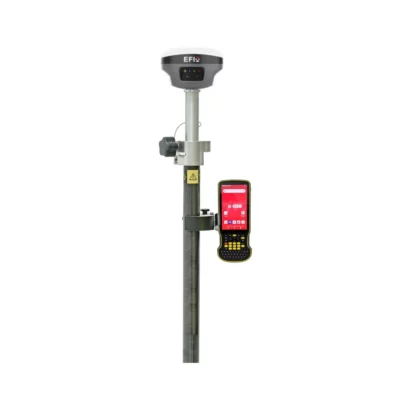
The EFIX F8L Rover Set is a compact laser IMU RTK GNSS solution for surveyors, construction teams, engineers, drone mapping professionals and GIS field crews who need fast, accurate measurements in real site conditions. It combines full-constellation GNSS tracking, 4D Auto-IMU tilt compensation, green laser measurement and visual stakeout tools in one practical rover package.
With its laser survey function, the EFIX F8L helps measure points that are difficult, unsafe or slow to reach with a pole, such as building corners, slopes, trenches, stockpiles, road edges and restricted areas. The included EFIX FC2 Android controller gives field teams a complete rover workflow for RTK measuring, stakeout and data collection.
EFIX F8L Rover Set Highlights
| Receiver type | Laser IMU RTK GNSS rover |
|---|---|
| GNSS channels | 1608 channels with GPS, GLONASS, Galileo, BeiDou, QZSS, NavIC/IRNSS and SBAS support |
| RTK accuracy | Horizontal 8 mm + 1 ppm RMS, vertical 15 mm + 1 ppm RMS |
| Laser survey | Green laser measurement up to 50 m |
| IMU tilt compensation | 4D Auto-IMU, 0° to 60° tilt angle |
| Field controller | EFIX FC2 Android handheld data controller included |

Valued customers:


Find RTK Networks
Search NTRIP providers and connect to reliable RTK correction services.
Description
EFIX F8L Rover Set for laser RTK surveying
The EFIX F8L Rover Set is designed for professionals who need accurate GNSS measurements without losing time on difficult point access. It is a complete rover package built around the EFIX F8L laser IMU RTK GNSS receiver and the EFIX FC2 Android data collector, making it suitable for day-to-day work in land surveying, construction layout, road projects, earthworks, utility mapping, drone ground control and GIS data collection.
For many field teams, the most useful part of the EFIX F8L is its combination of RTK GNSS, tilt compensation and laser measurement. Instead of always placing the pole exactly on the point, users can measure locations that are awkward, unsafe or physically blocked. This is useful around walls, fences, traffic areas, ditches, embankments, stockpiles, trenches and building corners where traditional GNSS work can become slow.
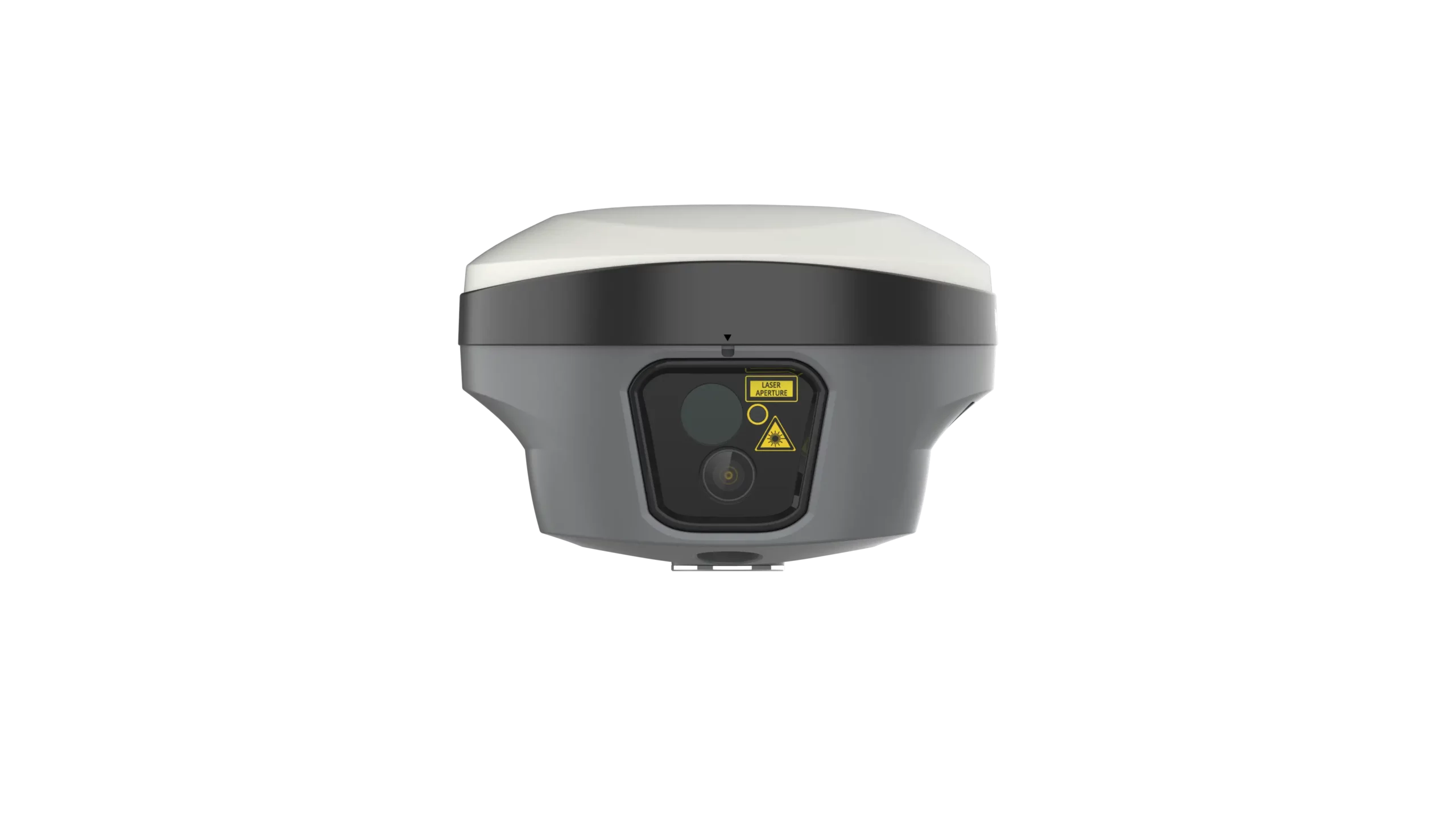
Measure difficult points with laser surveying
The EFIX F8L uses a green laser survey function to help capture points that are not easy to occupy directly. In practical fieldwork, this reduces the need for manual offsets and extra setups. A surveyor can aim at the point, measure it and keep moving, which is especially useful on construction sites, road edges, slopes, utility corridors and areas with restricted access.
The laser workflow is valuable for both surveying and construction teams. Surveyors can collect detail points faster during topographic work, while construction crews can measure or check locations without stepping into unsafe or inconvenient areas. For drone pilots, the rover can also support accurate ground control point measurement and site verification before or after a flight.
4D Auto-IMU tilt compensation for faster fieldwork
The built-in 4D Auto-IMU supports pole tilt compensation up to 60°. This helps users measure points faster because the pole does not need to be perfectly level for every observation. On uneven ground, near obstacles or in tight spaces, tilt compensation can make the difference between a slow setup and a smooth measurement workflow.
The IMU is calibration-free and designed to remain reliable around common jobsite conditions. That is helpful for construction and urban projects where metal fences, machines, vehicles and structures can make traditional compass-based workflows less convenient.
Full GNSS tracking for professional RTK work
The EFIX F8L tracks multiple satellite constellations across 1608 channels, including GPS, GLONASS, Galileo, BeiDou, QZSS, NavIC/IRNSS and SBAS. In the field, broader satellite tracking helps maintain availability and flexibility across different regions and working conditions.
Under suitable RTK conditions, the receiver supports centimetre-level positioning with 8 mm + 1 ppm horizontal accuracy and 15 mm + 1 ppm vertical accuracy. This makes it suitable for common professional tasks such as site surveys, setting out points, measuring boundaries, checking levels, mapping utilities and collecting accurate GIS features.
Visual stakeout and clear field guidance
The EFIX F8L supports visual field workflows that help users move from design data to the correct position on site. For construction layout and stakeout, visual guidance can make the process easier to understand for both experienced surveyors and field workers who need clear instructions in real time.
This is useful when setting out points, checking design positions, working with CAD data or navigating to a target in a busy construction environment. Instead of relying only on numbers and direction arrows, visual guidance helps the operator understand where to move and what to measure.
Complete rover set with EFIX FC2 controller
This rover set includes the EFIX FC2 handheld Android data controller. The controller is built for field use and gives the operator a practical interface for RTK survey, stakeout and data collection workflows. With the receiver and controller together, the EFIX F8L Rover Set is ready for professional GNSS fieldwork without having to build a system from separate components.
The FC2 controller is useful for surveyors, construction workers and GIS users who need a clear screen, reliable communication and a field-ready device for daily outdoor work. It supports a more complete workflow than using a receiver alone, especially when working with project files, point lists, stakeout tasks and correction services.
Built for outdoor survey conditions
The EFIX F8L receiver is compact and lightweight, making it practical for long days in the field. Its IP68 protection, IK08 impact rating and 2 m pole-drop resistance make it suitable for demanding outdoor work, including construction sites, infrastructure projects, road work and rough survey environments.
The internal battery supports long working sessions, with operating time depending on the selected workflow, temperature and device settings. For teams that move between laser survey, RTK rover work and visual stakeout, this makes the receiver a flexible tool for a wide range of jobs.
Who uses the EFIX F8L Rover Set?
The EFIX F8L Rover Set is a strong fit for land surveyors who need a compact RTK rover with laser and tilt features, construction professionals who perform layout and checks on site, engineers working on roads or infrastructure, GIS teams collecting accurate asset data, and drone pilots who need reliable ground control measurements.
It is also useful for companies that want one rover system for multiple types of work. A survey company can use it for topographic surveys and stakeout, a contractor can use it for site checks and layout, and a GIS team can use it for accurate field mapping.
Practical buying and support
Global GPS Systems supplies the EFIX F8L Rover Set for professionals who need accurate GNSS equipment with clear advice before purchase and support after delivery. This is helpful when choosing the right RTK setup, correction workflow, controller configuration or accessories for your type of work.
For buyers comparing laser RTK GNSS receivers, the EFIX F8L stands out because it combines laser measurement, IMU tilt compensation, full GNSS tracking, visual stakeout and a complete controller-based rover workflow in one compact system.
Typical applications
- Topographic surveying and detail measurement
- Construction layout and site checks
- Road, rail and infrastructure projects
- Earthworks, stockpile and slope measurement
- Utility mapping and GIS asset collection
- Drone ground control and verification points
Why choose the EFIX F8L Rover Set?
The EFIX F8L Rover Set is made for field teams that want to work faster without making the workflow complicated. The laser helps with points that are hard to reach, the IMU reduces time spent levelling the pole, and the GNSS engine provides the accuracy needed for professional RTK work.
For surveyors, it can reduce setup time and make difficult measurements easier. For construction teams, it helps turn design positions into clear field actions. For GIS users and drone pilots, it provides a compact way to collect accurate ground data with a professional rover setup.
Datasheets & Manuals
Datasheets and manuals
Specifications
EFIX F8L Rover Set Specifications
Product Overview
| Product Name | EFIX F8L Rover Set |
|---|---|
| Product Type | Laser IMU RTK GNSS rover set |
| Main Receiver | EFIX F8L GNSS receiver |
| Included Controller | EFIX FC2 handheld data controller |
| Primary Applications | Land surveying, construction layout, engineering surveys, road work, earthworks, GIS field data collection, utility mapping, site surveys and hard-to-reach point measurement |
| Main Technologies | Full-constellation GNSS, RTK, 4D Auto-IMU, laser survey, AR Vision Stakeout and eField workflow support |
GNSS Performance
| GNSS Channels | 1608 channels |
|---|---|
| GPS Signals | L1C/A, L2C, L2P(Y), L5 |
| GLONASS Signals | L1, L2, L3* |
| Galileo Signals | E1, E5a, E5b, E6* |
| BeiDou Signals | B1I, B2I, B3I, B1C, B2a, B2b* |
| QZSS Signals | L1C/A, L1C, L2C, L5 |
| NavIC / IRNSS Signals | L5 |
| SBAS Support | EGNOS L1, L5* |
| Positioning Rate | 1 Hz, 5 Hz and 10 Hz* |
| Time to First Fix | Cold start: <45 s; hot start: <10 s |
| Signal Re-acquisition | <1 s |
| PPP Support | PPP-B2b and E6B-HAS |
| PPP Accuracy | Horizontal: 10 cm; vertical: 20 cm |
GNSS Accuracy
| Positioning Mode | Horizontal Accuracy | Vertical Accuracy / Performance |
|---|---|---|
| RTK | 8 mm + 1 ppm RMS | 15 mm + 1 ppm RMS |
| RTK Initialization | <10 s | >99.9% initialization reliability |
| PPK | 3 mm + 1 ppm RMS | 5 mm + 1 ppm RMS |
| Post-processing Static | 2.5 mm + 0.5 ppm RMS | 5 mm + 0.5 ppm RMS |
| Code Differential | 0.4 m RMS | 0.8 m RMS |
| Autonomous | 1.5 m RMS | 2.5 m RMS |
Laser Survey
| Laser Survey Function | Green laser measurement for collecting 3D coordinates of hard-to-reach, unsafe or impractical points |
|---|---|
| Laser Range | Up to 50 m |
| Range Accuracy | 2 mm |
| Laser Type | Class 3R green laser |
| High-accuracy Laser Survey | 2 cm within 5 m; 3 cm within 10 m |
| Rapid Laser Survey | 3 cm within 5 m; 5 cm within 10 m |
| Laser Workflow | AI-assisted laser aiming and collection support through the F8L laser survey workflow |
IMU and Tilt Compensation
| IMU Type | 4D Auto-IMU |
|---|---|
| IMU Update Rate | 200 Hz |
| Tilt Angle | 0° to 60° |
| Additional Horizontal Pole-tilt Error | Typically less than 2.5 cm within 30° |
| Tilt Sensor | Calibration-free IMU for pole-tilt compensation |
| Magnetic Disturbance Resistance | Immune to magnetic disturbance |
| IMU Initialization | Automatic initialization in motion |
Vision and Camera Functions
| Camera Sensor Pixels | 5 MP and 2 MP |
|---|---|
| Field of View | 75° |
| Video Frame Rate | 25 fps |
| Vision Stakeout Accuracy | Horizontal: 8 mm + 1 ppm RMS; vertical: 15 mm + 1 ppm RMS |
| AR Vision Stakeout | Camera-based stakeout guidance with arrows, distance information and real-time field feedback through eField workflows |
| Field Workflow Support | Dynamic CAD map orientation, large CAD file handling, TIN earthwork calculation support and LandXML cut/fill visualization |
Communication and Connectivity
| Wi-Fi | 802.11 b/g/n/ac, access point mode |
|---|---|
| Bluetooth | Bluetooth v4.2 |
| NFC | Supported |
| USB Port | 1 × USB Type-C port for external power, data download and firmware update |
| UHF Antenna Port | 1 × UHF antenna port, SMA male |
| NTRIP | NTRIP Client and NTRIP Caster |
| Data Storage | 8 GB high-speed memory |
UHF Radio
| Radio Type | Standard internal UHF Tx/Rx radio |
|---|---|
| Frequency Range | 410–470 MHz |
| Transmit Power | 0.5 W, 1 W |
| Protocols | EFIX, Transparent, TT450, Satel* |
| Link Rate | 9,600 bps to 19,200 bps |
| Range | Typical 3 km; up to 8 km under optimal conditions |
| Radio Use Note | UHF radio use may be subject to local regulations and permitted frequency / power limits |
Data Formats
| RTCM | RTCM 2.x, RTCM 3.x |
|---|---|
| CMR | CMR input / output |
| Full Star | Supported |
| RINEX | RINEX 2.11, RINEX 3.02 and RINEX static formats |
| NMEA | NMEA 0183 output |
| ECN | ECN static format |
Receiver Electrical Specifications
| Battery Type | Rechargeable built-in lithium battery |
|---|---|
| Battery Capacity | 4900 mAh, 7.2 V |
| Power Consumption | Typical 2.0 W, depending on user settings |
| External Power Input | 5 V / 2 A |
| RTK Rover UHF Mode Without Camera | Up to 20 h |
| RTK Rover Laser Survey | Up to 15 h |
| RTK Rover Vision Stakeout | Up to 15 h |
| UHF RTK Base Mode | Up to 12 h |
Receiver Hardware and Environmental Specifications
| Dimensions | Φ133 mm × 90 mm; Φ5.24 in × 3.54 in |
|---|---|
| Weight | 800 g; 1.76 lb |
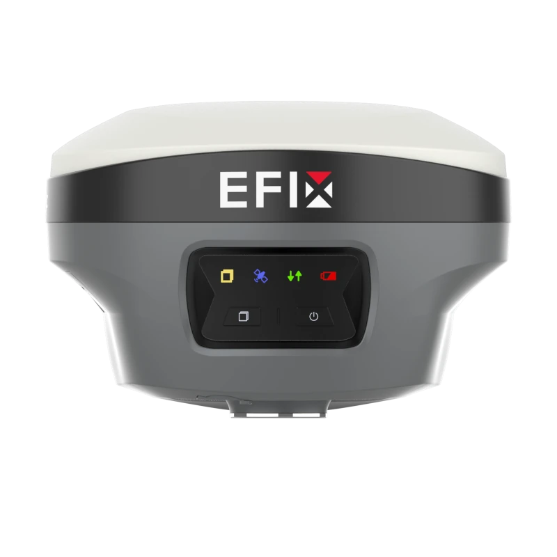
| Front Panel | 4 LED indicators + 2 buttons |
| Operating Temperature | -40°C to +65°C; -40°F to +149°F |
| Storage Temperature | -40°C to +85°C; -40°F to +185°F |
| Humidity | 100% non-condensing |
| Ingress Protection | IP68 waterproof and dustproof; protected from temporary immersion to a depth of 1 m |
| Shock Resistance Grade | IK08 |
| Drop Resistance | Survives a 2 m pole drop |
EFIX FC2 Data Collector
| Controller Model | EFIX FC2 |
|---|---|
| Operating System | Android 8.1 |
| Processor | MediaTek MTK6762 Octa Core 2.0 GHz |
| RAM | 4 GB |
| Internal Storage | 64 GB |
| Memory Expansion | MicroSD card, up to 128 GB |
| Display | 5.5 in IPS LTPS LCD capacitive multi-touch display |
| Display Resolution | HD 1440 × 720, 296 ppi, scratch-resistant glass |
| Keypad | Alphanumeric keypad |
| Camera | 13 MP rear camera with autofocus and flashlight |
| Mobile Network | 2G / 3G / 4G modem |
| Wi-Fi | IEEE 802.11 a/b/g/n/ac/d/e/h/i/k/r/v/w |
| Bluetooth | Bluetooth v5.0 BLE |
| USB | USB Type-C, OTG |
| Sensors | G-sensor, light sensor, NFC, gyroscope, e-compass and speaker |
| Battery Capacity | 6500 mAh |
| Operating Time | Up to 14 h under normal conditions |
| Charging Time | 4 h typical |
| Ingress Protection | IP67 |
| Drop Resistance | 2 m fall onto concrete |
| Weight | 375 g with battery |
| Dimensions | 225 mm × 80 mm × 17 mm; 8.9 in × 3.2 in × 0.79 in |
| Operating Temperature | -20°C to +55°C; -4°F to +131°F |
| Storage Temperature | -40°C to +70°C; -40°F to +158°F |
| Software Workflow | eField app integration for survey, stakeout, road, earthworks, CAD features, points, lines, polylines and surfaces |
| Certifications | CE, FCC, MIL-STD-810H, RoHS, WPC |
Package / Included Items
| Item | Quantity | Notes |
|---|---|---|
| EFIX F8L GNSS Receiver | 1 | Main laser IMU RTK GNSS rover receiver |
| EFIX FC2 Data Collector | 1 | Handheld Android field controller for RTK survey workflows |
| eField Workflow Compatibility | Included / supported | Used for survey, stakeout, CAD, road and earthwork workflows; license and software configuration may vary by supplier package |
Compliance and Notes
| Receiver Compliance Standards | IEC 62133-2:2017, EN IEC 62368-1:2020, UN Manual Section 38.3, IEC 60825-1:2007 |
|---|---|
| GNSS Signal Availability Note | Some listed GNSS signals and services may depend on commercial service availability or future firmware support |
| Accuracy Conditions | Accuracy and reliability are specified for open-sky conditions, free of multipath, with optimal GNSS geometry and atmospheric conditions |
| Laser Safety Note | Class 3R green laser; avoid direct eye contact with the beam |
| Battery Note | Battery life depends on operating temperature, device configuration and user settings |
Specifications and package contents may vary by configuration, region or manufacturer update. Always check the current configuration before ordering.
FAQ
EFIX F8L Rover Set FAQ
Product Overview
What is the EFIX F8L Rover Set?
The EFIX F8L Rover Set is a professional Laser IMU RTK GNSS rover package for accurate field measurement, surveying, construction layout, mapping and engineering work. It combines GNSS positioning, laser measurement, IMU tilt compensation, AR Vision Stakeout and a rugged field controller into one rover set.
Who is the EFIX F8L Rover Set designed for?
The EFIX F8L Rover Set is designed for land surveyors, construction professionals, civil engineers, road contractors, earthwork teams, utility mapping crews and GIS field teams that need accurate RTK GNSS measurements in demanding outdoor environments.
What is included in the EFIX F8L Rover Set?
The set includes the EFIX F8L GNSS receiver and the EFIX FC2 Android handheld data controller for RTK fieldwork with the eField software workflow.
What makes the EFIX F8L different from a standard GNSS rover?
The EFIX F8L adds laser measurement, 4D Auto-IMU tilt compensation and AR Vision Stakeout to standard RTK GNSS workflows. This helps users measure points that are hard to reach with a pole and stake out points with clearer visual guidance.
Which industries use the EFIX F8L Rover Set?
The EFIX F8L Rover Set is commonly used in land surveying, construction, civil engineering, road and infrastructure work, earthworks, utility mapping, site surveys, topographic surveys and GIS data collection.
Laser, IMU and Stakeout Features
What is the laser survey function used for?
The laser survey function allows users to measure points without placing the pole directly on the target. This is useful for building corners, walls, slopes, ditches, embankments, stockpiles, traffic areas, restricted zones and other hard-to-reach or unsafe points.
How far can the EFIX F8L laser measure?
The EFIX F8L has a laser range of up to 50 m. Laser accuracy depends on the selected laser mode, target conditions and field environment.
What laser accuracy does the EFIX F8L provide?
In high-accuracy laser survey mode, the EFIX F8L offers 2 cm accuracy within 5 m and 3 cm accuracy within 10 m. In rapid laser survey mode, it offers 3 cm accuracy within 5 m and 5 cm accuracy within 10 m.
What is 4D Auto-IMU tilt compensation?
4D Auto-IMU tilt compensation allows the rover to measure accurately while the pole is tilted. This reduces the need to level the pole for every point and helps speed up measurements near walls, fences, trenches, slopes and other difficult locations.
What tilt angle does the EFIX F8L support?
The EFIX F8L supports IMU tilt compensation from 0° to 60°. The IMU is calibration-free and designed to be immune to magnetic disturbance.
What is AR Vision Stakeout?
AR Vision Stakeout provides visual guidance during stakeout work by showing field direction, distance information and real-time guidance through the eField workflow. This helps users find design points more easily on construction sites and survey projects.
GNSS Accuracy and Connectivity
How accurate is the EFIX F8L in RTK mode?
The EFIX F8L provides RTK accuracy of 8 mm + 1 ppm horizontal and 15 mm + 1 ppm vertical under suitable field conditions.
How many GNSS channels does the EFIX F8L have?
The EFIX F8L has 1608 GNSS channels for full-constellation satellite tracking.
Which satellite constellations does the EFIX F8L support?
The EFIX F8L supports GPS, GLONASS, Galileo, BeiDou, QZSS, NavIC/IRNSS and SBAS signals, depending on regional availability, service support and firmware status.
Does the EFIX F8L support NTRIP corrections?
Yes, the EFIX F8L supports NTRIP Client and NTRIP Caster workflows, making it suitable for use with RTK correction networks where available.
Does the EFIX F8L have a built-in UHF radio?
Yes, the EFIX F8L includes a built-in UHF radio with a 410–470 MHz frequency range. The typical radio range is around 3 km and can reach up to 8 km in optimal conditions.
Do I need a base station with this rover set?
You do not always need a base station if you can use an RTK correction network through NTRIP. If there is no suitable correction network available, a compatible base station or a rover-base set may be required.
Field Use, Controller and Durability
Is the EFIX F8L Rover Set suitable for construction layout?
Yes, the EFIX F8L Rover Set is suitable for construction layout and stakeout. Its RTK accuracy, IMU tilt compensation, laser measurement and AR Vision Stakeout help construction teams transfer design data to the field efficiently.
Can the EFIX F8L be used for topographic surveys?
Yes, the EFIX F8L is suitable for topographic surveys, site surveys, engineering surveys, earthwork projects, road work and utility mapping where accurate GNSS positioning is required.
How long does the EFIX F8L battery last?
The internal 4900 mAh receiver battery supports up to 20 hours in RTK rover UHF mode without camera use, up to 15 hours during laser survey and up to 15 hours during Vision Stakeout. Battery life depends on settings, temperature and field use.
Is the EFIX F8L waterproof and dustproof?
Yes, the EFIX F8L receiver has an IP68 rating for dust and water protection. It is built for demanding outdoor survey and construction environments.
How rugged is the EFIX F8L receiver?
The EFIX F8L receiver has IK08 shock resistance and is specified to survive a 2 m pole drop. It also operates in temperatures from -40°C to +65°C.
What are the EFIX FC2 controller specifications?
The included EFIX FC2 data collector has a 5.5-inch HD display, 8-core 2.0 GHz processor, 4 GB RAM, 64 GB storage, 4G modem, Bluetooth 5.0, 13 MP rear camera, 6500 mAh battery, IP67 rugged rating and up to 2 m drop resistance.
What should affect the accuracy of my measurements?
Measurement accuracy can be affected by satellite visibility, multipath, GNSS geometry, atmospheric conditions, correction source, laser target conditions and correct surveying practice. For best results, use suitable RTK corrections and follow professional field procedures.
Videos
Reviews (1)
1 review for EFIX F8L Rover Set Laser IMU RTK GNSS Receiver
| 5 star | 100% | |
| 4 star | 0% | |
| 3 star | 0% | |
| 2 star | 0% | |
| 1 star | 0% |
Only logged in customers who have purchased this product may leave a review.

Soren Varga (verified owner) –
Good set. Camares work reallywell when staking out points