

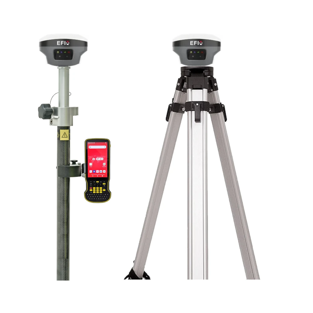


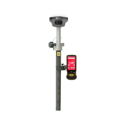
EFIX F8L Laser IMU RTK GNSS Rover Base Set
This product is Available
Contact our experts for the best possible price and configuration.
The EFIX F8L Rover & Base Set is a complete RTK GNSS solution for surveyors, construction teams, GIS users and engineers who need their own rover and base setup in the field. It combines multi-constellation GNSS, laser measurement, 4D Auto-IMU tilt compensation, vision stakeout and an internal UHF radio for reliable centimetre-level positioning on demanding jobsites.
With the integrated laser, the F8L can measure points that are unsafe, blocked or difficult to reach with a survey pole. The 60° IMU tilt function helps keep work moving when the pole cannot be held perfectly vertical, while the EFIX FC2 controller and eField software support practical survey, stakeout, road and earthwork workflows.
EFIX F8L Rover & Base Set Highlights
| GNSS Channels | 1608 channels |
|---|---|
| RTK Accuracy | 8 mm + 1 ppm horizontal, 15 mm + 1 ppm vertical |
| IMU Tilt | 4D Auto-IMU, 200 Hz, up to 60° tilt compensation |
| Laser Survey | Green Class 3R laser, up to 50 m range |
| Radio & Connectivity | Internal UHF 410–470 MHz, Wi-Fi, Bluetooth, NTRIP support |
| Field Controller | EFIX FC2 with 5.5 inch display, 4G, 6500 mAh battery and IP67 protection |

Valued customers:


Find RTK Networks
Search NTRIP providers and connect to reliable RTK correction services.
Description
EFIX F8L Rover & Base Set for professional RTK surveying
The EFIX F8L Rover & Base Set is designed for field teams that want a complete GNSS rover and base configuration without depending only on local correction networks. It is suitable for land surveying, construction layout, civil engineering, road work, earthworks, utilities, GIS mapping and general site measurement tasks where accurate positioning and practical field usability matter.
This set combines the EFIX F8L laser IMU-RTK GNSS receiver with the EFIX FC2 data collector, giving users a compact but capable system for collecting points, setting out designs, checking levels, measuring inaccessible points and managing field data in eField software.
Laser measurement for difficult points
The F8L includes an integrated green laser that helps measure points where placing a pole is difficult, unsafe or inefficient. This is useful around fences, walls, trenches, traffic areas, stockpiles, building corners, water edges and other locations where a direct pole setup is not practical.
Instead of stopping work to create offsets or reach awkward points manually, the operator can aim the laser and collect the coordinate from a safer or more convenient position. For construction workers and surveyors, this can make daily fieldwork faster and reduce unnecessary movement around hazards.
Multi-constellation GNSS with RTK performance
The EFIX F8L tracks multiple GNSS constellations including GPS, GLONASS, Galileo, BeiDou, QZSS, NavIC and SBAS signals. With 1608 channels and RTK accuracy specified at 8 mm + 1 ppm horizontally and 15 mm + 1 ppm vertically, it is built for precise positioning in normal professional survey conditions.
In real fieldwork, this means the receiver is suitable for topographic surveys, site control, boundary work, machine control preparation, as-built checks, stakeout and other centimetre-level tasks. The broad signal tracking helps maintain stable performance across different regions and job environments.
4D Auto-IMU tilt compensation
The built-in 4D Auto-IMU supports pole tilt measurement up to 60°. This helps users keep collecting accurate points when the pole cannot be held perfectly vertical, such as near walls, under trees, beside parked machinery or on uneven ground.
For everyday survey crews, IMU tilt can reduce the number of setups, speed up point collection and make stakeout more comfortable. It is especially useful for construction and GIS teams who need efficient measurements but do not always work in open, ideal survey conditions.
Vision stakeout and practical eField workflows
The F8L supports vision-based stakeout workflows through eField, helping operators navigate to points more intuitively using visual guidance. This is useful for crews who need to set out points quickly on construction sites, road projects and engineering layouts.
The eField software supports points, lines, polylines, surfaces, CAD features, road work and earthwork tasks. For users working with drawings, terrain models or design data, this creates a more direct connection between office plans and field execution.
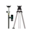
Rover and base flexibility with UHF radio
Because this package includes a rover and base configuration, it is a strong choice for teams working in areas where RTK network coverage is limited, unreliable or unavailable. The internal UHF radio operates in the 410–470 MHz range and supports base-rover communication for local corrections.
This is useful for construction sites, rural survey work, infrastructure corridors, agricultural mapping and remote projects where having your own base station gives more control over the correction source.
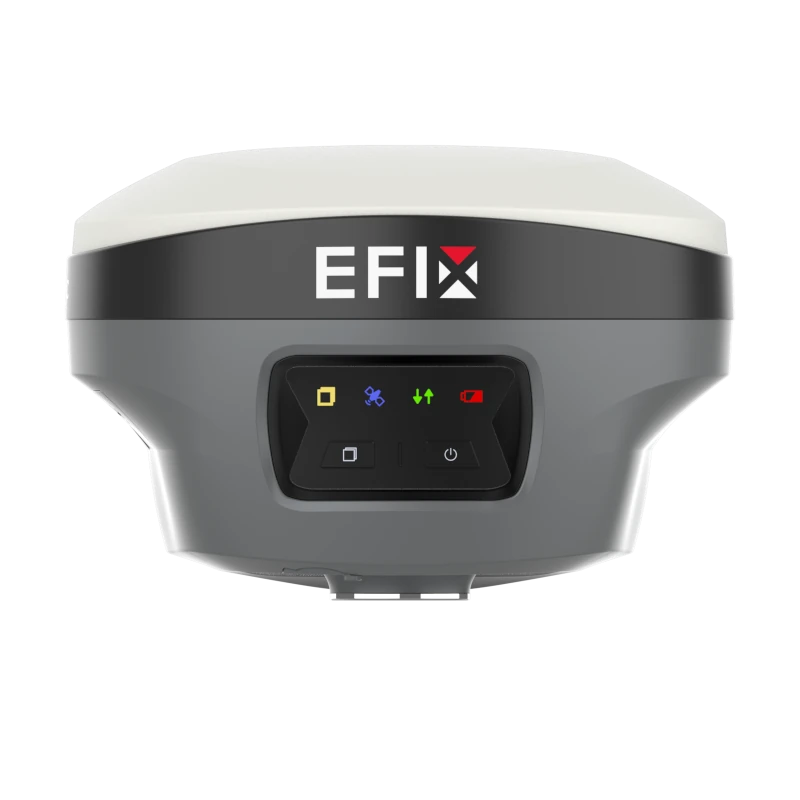
Rugged receiver for demanding field conditions
The EFIX F8L receiver is built for professional outdoor use. It has IP68 protection against dust and water, IK08 shock resistance and is specified to survive a 2 metre pole drop. The receiver weighs about 800 g, making it compact enough for long days in the field without adding unnecessary weight to the pole.
The internal battery supports long operating times depending on the working mode, including RTK rover, laser survey, vision stakeout and UHF base use. This makes the set suitable for full survey days, provided normal charging and battery planning are followed.
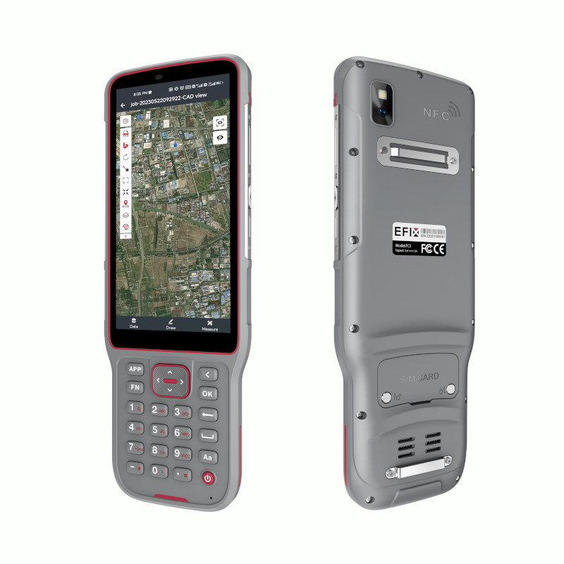
EFIX FC2 controller included
The included EFIX FC2 data collector gives the operator a rugged Android-based controller for running field software, managing projects and communicating with the receiver. It has a 5.5 inch sunlight-readable display, 4 GB RAM, 64 GB storage, 4G connectivity, Wi-Fi, Bluetooth 5.0, NFC and a 13 MP rear camera.
With IP67 protection, a 2 metre drop rating and a 6500 mAh battery, the FC2 is made for real jobsite conditions. It is a practical controller for surveyors, engineers and construction workers who need a dedicated field device instead of relying on a standard phone or tablet.
Who is the EFIX F8L Rover & Base Set for?
The EFIX F8L Rover & Base Set is a good fit for professionals who need a complete GNSS system for accurate measurement and layout. Surveyors can use it for topographic work, control points, stakeout and as-built measurements. Construction teams can use it for site layout, checking positions and working from CAD or road data. GIS and utility users can collect accurate asset locations, while drone and mapping teams can use it for ground control points and verification work.
It is especially useful for buyers who want modern GNSS features such as laser measurement, IMU tilt and vision stakeout in one package, while still having the flexibility of a base and rover setup for independent RTK work.
Buying from Global GPS Systems
Global GPS Systems supplies the EFIX F8L Rover & Base Set with specialist support for survey, construction, GIS and mapping users. Our team can help you compare this set with other RTK GNSS receivers, understand correction options and choose the right configuration for your fieldwork.
For companies upgrading from older GNSS equipment or purchasing their first rover and base set, the EFIX F8L offers a practical balance of modern survey functions, rugged hardware and field-focused usability.
Datasheets & Manuals
Datasheets and manuals
Specifications
EFIX F8L Rover & Base Set Specifications
Product Overview
| Product Name | EFIX F8L Rover & Base Set |
|---|---|
| Product Type | GNSS RTK rover and base surveying set |
| Receiver Model | EFIX F8L Advanced Laser Pocket-Size IMU-RTK |
| Controller Model | EFIX FC2 Handheld Data Controller |
| Main Applications | Topographic survey, RTK base/rover work, stakeout, road work, earthworks, engineering and construction surveying |
| Key Technologies | Full-constellation GNSS, laser survey, 4D Auto-IMU, AR navigation, Vision Stakeout and eField software workflows |
GNSS Performance
| GNSS Channels | 1608 channels |
|---|---|
| GPS Signals | L1C/A, L2C, L2P(Y), L5 |
| GLONASS Signals | L1, L2, L3* |
| Galileo Signals | E1, E5a, E5b, E6* |
| BeiDou Signals | B1I, B2I, B3I, B1C, B2a, B2b* |
| QZSS Signals | L1C/A, L1C, L2C, L5 |
| NavIC / IRNSS | L5 |
| SBAS | EGNOS L1, L5* |
| PPP Support | PPP-B2b, E6B-HAS |
| Positioning Rate | 1 Hz, 5 Hz and 10 Hz; 10 Hz noted as firmware-upgrade dependent in the datasheet |
| Time to First Fix | Cold start: <45 s; hot start: <10 s |
| Signal Re-acquisition | <1 s |
GNSS Accuracy
| Mode | Horizontal Accuracy | Vertical Accuracy |
|---|---|---|
| Real-Time Kinematic RTK | 8 mm + 1 ppm RMS | 15 mm + 1 ppm RMS |
| Post-Processing Kinematic PPK | 3 mm + 1 ppm RMS | 5 mm + 1 ppm RMS |
| Post-Processing Static | 2.5 mm + 0.5 ppm RMS | 5 mm + 0.5 ppm RMS |
| Code Differential | 0.4 m RMS | 0.8 m RMS |
| Autonomous | 1.5 m RMS | 2.5 m RMS |
| Vision Stakeout | 8 mm + 1 ppm RMS | 15 mm + 1 ppm RMS |
| PPP | 10 cm | 20 cm |
RTK Initialization
| RTK Initialization Time | <10 s |
|---|---|
| RTK Initialization Reliability | >99.9% |
| RTK Engine | Advanced Full-Star algorithm with full-constellation and multi-frequency tracking |
Laser Survey
| Laser Survey Function | Integrated laser survey for measuring difficult-to-fix, hard-to-reach, signal-blocked or hazardous points |
|---|---|
| High-Accuracy Laser Survey | 2 cm within 5 m; 3 cm within 10 m |
| Rapid Laser Survey | 3 cm within 5 m; 5 cm within 10 m |
| Laser Range | Up to 50 m |
| Range Accuracy | 2 mm |
| Laser Type | Class 3R green laser |
| Laser Assistance | Bright green laser dot with AI-powered edge-computing SoC assistance for aiming and collection |
IMU and Tilt Compensation
| IMU Type | 4D Auto-IMU |
|---|---|
| IMU Update Rate | 200 Hz |
| IMU Tilt Angle | 0° to 60° |
| Additional Horizontal Pole-Tilt Error | Typically less than 2.5 cm within 30° |
| IMU Initialization | Automatic initialization while in motion |
| Tilt Sensor | Calibration-free IMU for pole-tilt compensation; immune to magnetic disturbance |
Vision, Camera and AR Functions
| Receiver Camera Pixels | 5 MP and 2 MP |
|---|---|
| Camera Field of View | 75° |
| Video Frame Rate | 25 fps |
| AR Navigation | AR navigation with visual arrows and real-time distance readouts |
| Vision Stakeout | eField AR overlay for viewing stakeout points against the actual ground scene |
| Vision Workflow Benefit | Designed to improve stakeout and survey workflows without complex offset methods |
Receiver Communication
| Wi-Fi | 802.11 b/g/n/ac, access point mode |
|---|---|
| Bluetooth | Bluetooth v4.2 |
| NFC | Supported |
| USB Port | 1 x USB Type-C port for external power, data download and firmware update |
| UHF Antenna Port | 1 x UHF antenna port, SMA male |
| NTRIP | NTRIP Client and NTRIP Caster |
UHF Radio
| Internal UHF Radio | Standard internal transmit/receive radio |
|---|---|
| Frequency Range | 410 MHz to 470 MHz |
| Transmit Power | 0.5 W, 1 W |
| Protocols | EFIX, Transparent, TT450, Satel* |
| Link Rate | 9,600 bps to 19,200 bps |
| Radio Range | Typical 3 km; up to 8 km under optimal conditions |
| Regulatory Note | UHF radio use may be subject to local frequency and power regulations |
Data Formats and Storage
| RTCM Support | RTCM 2.x, RTCM 3.x |
|---|---|
| CMR Support | CMR input/output |
| RINEX Support | RINEX 2.11, RINEX 3.02 |
| NMEA Output | NMEA 0183 output |
| Static Formats | ECN and RINEX static formats |
| Receiver Data Storage | 8 GB high-speed memory |
Receiver Electrical Specifications
| Battery Type | Rechargeable built-in lithium battery |
|---|---|
| Battery Capacity | 4900 mAh, 7.2 V |
| Power Consumption | Typical 2.0 W, depending on user settings |
| External Power Input | 5 V / 2 A |
| RTK Rover UHF Mode Runtime, No Camera | Up to 20 h |
| RTK Rover Laser Survey Runtime | Up to 15 h |
| RTK Rover Vision Stakeout Runtime | Up to 15 h |
| UHF RTK Base Runtime | Up to 12 h |
Receiver Physical and Environmental Specifications
| Receiver Dimensions | Ø133 mm x 90 mm |
|---|---|
| Receiver Weight | 800 g |
| Front Panel | 4 LED indicators and 2 buttons |
| Operating Temperature | -40°C to +65°C |
| Storage Temperature | -40°C to +85°C |
| Humidity | 100% non-condensing |
| Ingress Protection | IP68 waterproof and dustproof; protected from temporary immersion to 1 m depth |
| Shock Resistance Grade | IK08 |
| Drop Resistance | Survives a 2 m pole drop |
Receiver Compliance
| International Standards | IEC 62133-2:2017, EN IEC 62368-1:2020, UN Manual Section 38.3, IEC 60825-1:2007 |
|---|---|
| Laser Safety Note | Class 3R green laser; avoid direct eye contact with beam |
EFIX FC2 Data Collector System
| Operating System | Android 8.1 |
|---|---|
| Processor | MediaTek MTK6762 Octa Core 2.0 GHz |
| RAM | 4 GB |
| Flash Memory | 64 GB |
| Memory Extension | Micro SD card, up to 128 GB |
| Field Software | eField app for points, lines, polylines, surfaces, codes, on-site drawing and CAD-based workflows |
EFIX FC2 Data Collector Display and Input
| Display Size | 5.5 inch IPS LTPS LCD display |
|---|---|
| Touchscreen | Capacitive multi-touch screen |
| Display Resolution | HD 1440 x 720 |
| Pixel Density | 296 ppi |
| Glass | Scratch-resistant glass |
| Outdoor Visibility | Sunlight-readable display |
| Keypad | Alphanumeric keypad |
EFIX FC2 Data Collector Communications
| Network Modem | 2G / 3G / 4G mobile network support |
|---|---|
| FDD-LTE Bands | B1, B2, B3, B4, B5, B7, B8, B12, B17, B20, B28AB |
| TDD-LTE Bands | B34, B38, B39, B40, B41 |
| TD-SCDMA Bands | B34, B39 |
| WCDMA Bands | B1, B2, B4, B5, B8 |
| GSM Bands | 850, 900, 1800, 1900 |
| EV-DO | BC0 |
| Wi-Fi | 802.11 a/b/g/n/ac/d/e/h/i/k/r/v/w |
| Bluetooth | Bluetooth v5.0 BLE |
| USB | USB Type-C, OTG |
| NFC | Supported |
EFIX FC2 Data Collector Camera and Sensors
| Rear Camera | 13 MP rear camera with autofocus |
|---|---|
| Flashlight | Supported |
| Sensors | G-sensor, light sensor, NFC, gyroscope, E-compass and speaker |
EFIX FC2 Data Collector Electrical Specifications
| Battery Capacity | 6500 mAh Li-ion battery |
|---|---|
| Operating Time | Up to 14 h under normal conditions |
| Charging Time | 4 h typical |
EFIX FC2 Data Collector Physical and Environmental Specifications
| Controller Dimensions | 225 mm x 80 mm x 17 mm |
|---|---|
| Controller Weight | 375 g with battery |
| Ingress Protection | IP67 dust and water protection |
| Operating Temperature | -20°C to +55°C |
| Storage Temperature | -40°C to +70°C |
| Shock and Vibration | 2 m fall onto concrete |
EFIX FC2 Data Collector Certifications
| Certifications | CE, FCC, MIL-STD-810H, RoHS, WPC |
|---|
Software and Workflow Features
| Field Software | eField app |
|---|---|
| CAD Orientation | Dynamic map orientation that rotates the CAD base map to align with the surveyor viewpoint |
| Large CAD Handling | Supports navigation and editing of large-scale CAD drawings |
| TIN Tools | TIN optimization for earthwork calculations using filtering techniques |
| Road Stakeout | LandXML cut/fill visualization for road stakeout workflows |
| Supported Field Objects | Points, lines, polylines and surfaces |
| Field Functions | Topographic survey, stakeout, road, earthworks, features, codes and on-site drawing |
Package / Included Items
| Item | Quantity | Notes |
|---|---|---|
| EFIX F8L GNSS Receiver | Configuration-dependent | Used for rover and base RTK operation in this set configuration |
| EFIX FC2 Data Collector | Configuration-dependent | Handheld Android field controller for eField workflows |
| eField Field Software | Configuration-dependent | Used for survey, stakeout, CAD and road/earthwork workflows |
| UHF / RTK Accessories | Configuration-dependent | Exact accessories are not fully itemized in the source listing or datasheets |
| Power and Charging Accessories | Configuration-dependent | Exact contents may vary by package configuration |
Specifications and package contents may vary by configuration, region or manufacturer update. Always check the current configuration before ordering.
FAQ
EFIX F8L Rover & Base Set FAQ
Product Overview
What is the EFIX F8L Rover & Base Set?
The EFIX F8L Rover & Base Set is a complete professional GNSS surveying solution that combines two F8L receivers for base and rover operation with laser measurement, RTK positioning, 4D Auto-IMU tilt compensation, AR navigation, Vision Stakeout, eField software and a rugged field controller.
Who is the EFIX F8L Rover & Base Set designed for?
This set is designed for land surveyors, construction layout teams, civil engineers, road contractors, earthwork professionals, mapping teams and infrastructure specialists who need accurate, efficient positioning in the field.
What is the advantage of buying a rover and base set?
A rover and base set allows one receiver to work as the local reference station and the other as the rover. This gives survey teams more control over RTK corrections, especially on sites where a permanent correction network is unavailable or where a local base setup is preferred.
What types of work can the EFIX F8L be used for?
The EFIX F8L can be used for topographic surveying, construction stakeout, road layout, earthworks, volume measurements, utility mapping, boundary work, site control and measuring points in hard-to-reach or obstructed locations.
Is the EFIX F8L suitable for construction sites?
Yes. The EFIX F8L is built for professional construction and engineering environments. Its RTK accuracy, laser measurement, tilt compensation, AR navigation and rugged housing make it useful for layout, stakeout, as-built checks and daily field measurements.
Accuracy, GNSS and RTK Performance
What accuracy can the EFIX F8L achieve?
The EFIX F8L is designed for centimeter-level RTK positioning when used under suitable GNSS conditions with proper correction data, good satellite visibility and correct field setup.
How many GNSS channels does the EFIX F8L have?
The EFIX F8L uses 1608 GNSS channels, allowing it to track multiple satellite constellations and frequencies for stable positioning performance in professional survey applications.
Which satellite constellations does the EFIX F8L support?
The EFIX F8L supports major GNSS constellations including GPS, GLONASS, Galileo, BeiDou, QZSS, NavIC and SBAS, depending on signal availability, firmware support and regional conditions.
Does the EFIX F8L support RTK surveying?
Yes. The EFIX F8L supports RTK surveying and can be configured for base and rover workflows. The rover can be used with UHF radio corrections or cellular correction workflows depending on the field setup.
How fast does the EFIX F8L initialize?
The EFIX F8L is designed for fast RTK initialization, helping field teams start measurements quickly and reduce downtime during surveying and stakeout tasks.
Can the EFIX F8L be used for static or post-processing work?
Yes. The F8L can record static survey data and supports workflows where raw data is downloaded for office processing, including formats used for post-processing applications.
Laser, IMU and Field Productivity
What does the laser function on the EFIX F8L do?
The laser function allows users to measure 3D coordinates of points that may be difficult, unsafe or inconvenient to reach with a survey pole. This is useful near obstacles, traffic, trenches, walls, fences, slopes and other challenging locations.
When should I use laser measurement instead of pole measurement?
Laser measurement is useful when the point cannot be easily reached with the pole, when access is unsafe, or when a direct pole setup would slow down the survey. It helps users capture difficult points while staying in a safer and more practical position.
What is 4D Auto-IMU tilt compensation?
4D Auto-IMU tilt compensation allows the receiver to measure accurately while the pole is tilted. This helps surveyors work faster around obstacles and reduces the need to keep the pole perfectly vertical for every measurement.
Does the EFIX F8L need a complicated IMU calibration process?
No. The EFIX F8L is designed with automatic IMU initialization. After tilt survey is enabled, the receiver can initialize through normal movement, helping users begin tilted measurements quickly in the field.
What is AR Navigation on the EFIX F8L?
AR Navigation provides visual guidance for field navigation and stakeout. It helps users find target points more intuitively by combining real-time positioning information with visual direction cues.
What is Vision Stakeout used for?
Vision Stakeout helps users locate and stake out points visually in the field. It is especially useful on busy construction sites or complex layouts where visual guidance can make point location faster and easier.
Controller, Software, Durability and Setup
What controller is included with the EFIX F8L Rover & Base Set?
The set includes the EFIX FC2 data collector, a rugged field controller with a 5.5-inch HD display, 8-core processor, 4 GB RAM, 64 GB storage, Bluetooth, 4G connectivity, rear camera and a high-capacity battery for field operation.
What software is used with the EFIX F8L?
The EFIX F8L is used with the eField app, which supports common field workflows such as point measurement, line and surface management, CAD handling, stakeout, road work and field data collection.
Does eField support CAD and road workflows?
Yes. eField supports CAD-based workflows, including large CAD drawings, dynamic CAD orientation, TIN optimization, earthwork calculations and LandXML cut-fill visualization for road and construction stakeout tasks.
Is the EFIX F8L waterproof and dustproof?
Yes. The EFIX F8L receiver is designed for rugged field use with IP68 protection against water and dust, making it suitable for demanding outdoor surveying and construction environments.
How durable is the EFIX F8L receiver?
The EFIX F8L is built for harsh field conditions. It is impact-resistant, designed to survive drops up to 2 meters, and can operate across a wide temperature range from very cold to very hot jobsite conditions.
How do the base and rover connect during field work?
The base and rover can be configured through the field software. For UHF workflows, the SMA whip antenna is connected to the receiver. The rover can also be configured for cellular rover operation depending on the correction source and project requirements.
Do I need to check radio regulations before using UHF mode?
Yes. UHF radio regulations can vary by country or region. Before using radio correction workflows, users should confirm whether local authorization, frequency restrictions or operating permits apply.
Reviews (0)
Only logged in customers who have purchased this product may leave a review.

Reviews
There are no reviews yet