

 GPS & GNSS
 Lidar scanning
 Total Station





SingularXYZ Orion ONE Visual Laser RTK Rover Base Set
Get the best price for your setup
Contact our experts for the best possible price and configuration.
- Fast response
- Expert configuration advice
- No overpaying for features you do not need
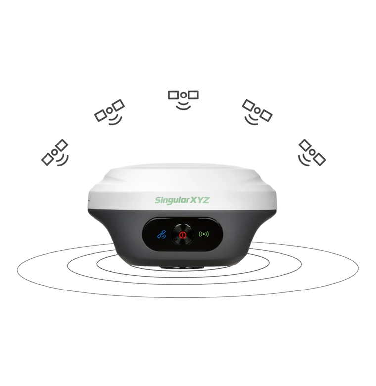
The SingularXYZ Orion ONE Rover and Base Set is a complete RTK GNSS solution for surveyors, construction crews, civil engineers and GIS professionals who need their own local correction source. One Orion ONE receiver operates as the base station while the second is used as the rover, allowing centimetre-level positioning without depending entirely on a third-party RTK network.
The system combines full-constellation GNSS tracking with camera-guided AR stakeout, non-contact laser surveying and 60° IMU tilt compensation. These tools help crews set out points more intuitively, measure beside obstacles and record locations where placing the pole tip directly on the target is difficult or unsafe.
Both compact receivers are designed for demanding field use, with IP67 protection, long battery life and wireless connectivity. The set is suitable for topographic surveying, construction layout, roadwork, utility mapping, as-built surveys and other precision positioning tasks.
SingularXYZ Orion ONE Rover and Base Set Highlights
| System configuration | Two Orion ONE GNSS receivers for local base and rover operation |
|---|---|
| GNSS tracking | 1,408 channels with GPS, GLONASS, Galileo, BeiDou, QZSS, NavIC and SBAS support |
| RTK accuracy | 8 mm + 1 ppm horizontal and 15 mm + 1 ppm vertical |
| Visual stakeout | 2 MP starlight-grade camera with AR guidance and a 75° field of view |
| Laser surveying | Non-contact measurement at distances up to 10 metres |
| Tilt compensation | IMU pole and laser surveying at tilt angles up to 60° |
| Radio operation | 410–470 MHz UHF base-to-rover corrections with compatible radio configuration |
| Field protection | IP67-rated receiver housings with up to 12 hours of battery operation |


Valued customers:










Find RTK Networks
Search NTRIP providers and connect to reliable RTK correction services.
Description
A complete local RTK base and rover solution
The SingularXYZ Orion ONE Rover and Base Set provides two compact GNSS receivers for professional RTK surveying. One receiver is configured as the base station and transmits correction data, while the second operates as the rover used to measure or stake out points across the site.
This arrangement gives surveyors and construction teams control over their own correction source. It is particularly useful on projects where a CORS or NTRIP service is unavailable, unreliable or unsuitable for the required workflow. The same equipment can also be used with compatible network corrections when local coverage is available.
The set is designed for land surveying, construction layout, civil engineering, utility work, GIS data collection and as-built documentation. Its visual, laser and tilt-assisted functions also help crews handle points that are awkward to measure with a conventional vertical survey pole.
Operate with your own base station
For local radio RTK, the base receiver is established over a known control point or assigned a project coordinate. It then broadcasts correction data to the rover through the internal UHF radio system. The rover applies these corrections to calculate a centimetre-level position in real time.
This workflow is practical for construction sites, road projects, earthworks, rural surveys and temporary control networks. Crews can work independently of mobile-data coverage and avoid relying on the distance or availability of an external reference station.
The base and rover must use compatible radio versions, frequencies and communication protocols. Their settings are matched in SingularPad before work begins. Available radio options can differ by regional configuration, so the intended operating country and existing equipment should be considered when selecting the set.
Visual guidance for easier stakeout
The Orion ONE includes a 2 MP starlight-grade camera for visual AR stakeout. Instead of relying only on arrows, bearings and numerical distances, the operator can see guidance overlaid on a live view of the working area.
This makes it easier to relate the design point to nearby features such as kerbs, foundations, road edges, piles or service routes. The visual workflow can be especially helpful for construction personnel and occasional GNSS users who find camera guidance easier to interpret than a conventional plan view.
The camera has a wide field of view and is intended to remain usable in weaker lighting conditions. Actual image quality will still depend on weather, available light and the surrounding site environment.
Non-contact laser measurement
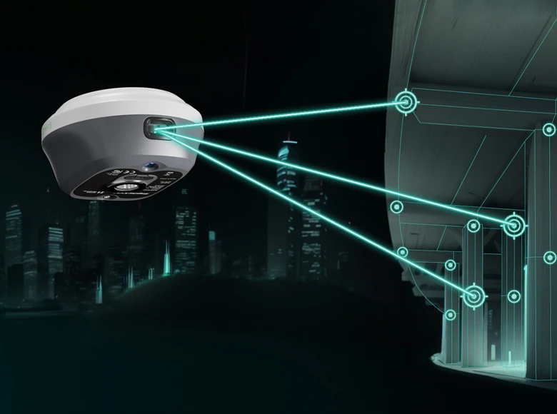
The integrated laser allows selected points to be measured from a distance of up to 10 metres. The operator can stand where the rover has a suitable GNSS solution and aim at a target that cannot be occupied directly with the pole tip.
This is useful for points across trenches, beside moving traffic, near water, on steep slopes or close to unstable ground. It can also support measurements beneath obstructions, beside building façades and around utility features where normal pole placement would be inconvenient or unsafe.
Laser surveying expands the number of points that can be completed with the GNSS rover, although it does not replace every total-station or direct-contact workflow. Results depend on target visibility, surface characteristics, measurement distance, tilt angle and the quality of the active RTK solution.
60° IMU tilt compensation
The built-in IMU supports measurements with the survey pole tilted by up to 60°. This means the operator does not need to level the pole perfectly for every observation.
In everyday fieldwork, tilt compensation helps when working beside walls, fences, machinery, parked vehicles, material piles and excavation edges. It also reduces repeated pole-levelling during dense topographic surveys and construction checks.
The IMU can also support the laser workflow by accounting for the receiver orientation. Correct initialisation and a reliable fixed RTK solution remain important when collecting final survey coordinates.
Full-constellation satellite tracking
Each Orion ONE receiver uses a 1,408-channel GNSS engine and supports signals from GPS, GLONASS, Galileo, BeiDou and QZSS, together with NavIC and supported SBAS services.
Tracking several constellations and frequencies gives the receiver access to more satellite observations across the sky. This can improve positioning availability around buildings, vegetation and partial overhead obstructions, although every GNSS system still requires an adequate view of the sky for dependable results.
Under suitable conditions, specified RTK accuracy is 8 mm + 1 ppm horizontally and 15 mm + 1 ppm vertically. Typical RTK initialisation is stated as less than five seconds. Actual performance depends on the base position, correction quality, radio link, baseline length, satellite geometry and the local environment.
Flexible field workflows with SingularPad
SingularPad is the Android field application used to configure the receivers, start base and rover modes and complete survey tasks. Supported workflows include point surveying, point stakeout, visual stakeout, laser surveying, CAD mapping, road stakeout, localisation, area calculations and static data collection.
For internal-radio operation, the base and rover are assigned the same frequency and protocol. The software then displays the rover solution status and correction age, helping the operator confirm that a fixed RTK solution has been achieved before recording a point.
The rover can also receive internet corrections through a connected Android controller using an NTRIP or CORS service. This provides an alternative to the local base when a suitable network is available.
Static observations and survey data
The receivers can record raw static observations to internal storage for later conversion to RINEX. This supports control surveys, post-processing and other work where field crews need more than real-time RTK coordinates.
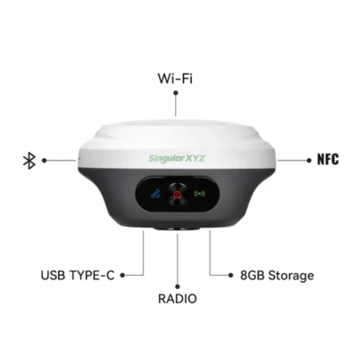
Bluetooth, NFC, Wi-Fi and USB Type-C provide options for connecting controllers, managing receiver settings, charging and transferring data. A browser-based WebUI can also be used for receiver access and file management.
Compact equipment for demanding sites
Each receiver has a palm-sized body measuring approximately 107 mm in diameter and 58.7 mm high. The low-profile design keeps the equipment manageable on a survey pole and makes the pair easier to transport between projects.
The receiver housing is rated IP67 for protection against dust and temporary water exposure. Battery operation is specified at up to approximately 12 hours, depending on radio output, enabled sensors, temperature and working conditions.
For a base-and-rover crew, the compact format means the base can be established without transporting an unnecessarily large receiver, while the rover remains comfortable to use during a full day of point collection and stakeout.
Typical applications
- Topographic and cadastral field surveys
- Construction setting out and site control
- Road, rail and civil infrastructure projects
- Earthworks, grading and volume checks
- Utility and GIS asset mapping
- As-built surveys and progress documentation
- Remote measurements near inaccessible or hazardous points
Configuration and support from Global GPS Systems
The correct set configuration depends on the required UHF frequency range, radio protocol, controller, survey poles, tripod or base accessories and local correction workflow. Compatibility should also be checked when the equipment will be used with existing radios or third-party GNSS receivers.
Global GPS Systems can help select the appropriate base and rover configuration for the operating country, project coordinate system and intended field software. Support is also available for setting up the local base, matching radio settings and connecting the rover to an NTRIP or CORS service.
Specifications
SingularXYZ Orion ONE Rover & Base Set Specifications
System Overview
| Product type | Professional dual-receiver RTK GNSS rover and base station surveying set |
|---|---|
| Receiver model | SingularXYZ Orion ONE |
| System configuration | One receiver configured as an RTK base station and one receiver configured as an RTK rover |
| Primary applications | Land surveying, construction layout, cadastral surveying, topographic surveying, point stakeout, road stakeout, CAD mapping, area measurement, volume calculation, static surveying and non-contact laser measurement |
| Integrated technologies | Multi-constellation GNSS, visual AR stakeout, laser distance measurement, tilt-compensating IMU, internal UHF radio, Bluetooth, NFC and Wi-Fi |
| GNSS channels per receiver | 1408 simultaneous tracking channels |
| Maximum IMU tilt angle | 60° |
| Laser measurement range | Up to 10 m |
| Integrated cellular modem | None; internet-based corrections require a connected field controller or mobile device |
Base and Rover Operation
| Function | Base Receiver | Rover Receiver |
|---|---|---|
| Primary role | Generates and transmits RTK correction data | Receives correction data and calculates centimeter-level positions |
| Internal UHF mode | Transmit-capable base configuration required | Receives UHF corrections from the base |
| Radio frequency | 410 to 470 MHz | 410 to 470 MHz |
| Radio settings | Base and rover must use matching protocol, frequency and compatible channel settings | Base and rover must use matching protocol, frequency and compatible channel settings |
| Base startup options | Known-point or assigned-coordinate base setup; single-point startup may also be available through SingularPad | Not applicable |
| Network RTK operation | Correction transmission and NTRIP functions depend on the selected workflow and connected device | Supports NTRIP or TCP correction access through an internet-connected controller |
| Static observation | Supported | Supported |
| Visual and laser surveying | Available when used as a mobile receiver | Supported |
Satellite Tracking
| Constellation or Service | Supported Signals |
|---|---|
| GPS | L1C/A, L1C, L2C, L2P(Y), L5 |
| BeiDou | B1I, B2I, B3I, B1C, B2a, B2b |
| GLONASS | G1, G2, G3 |
| Galileo | E1, E5a, E5b, E6 |
| QZSS | L1C/A, L1C, L2C, L5 |
| NavIC | L5 |
| SBAS | WAAS, EGNOS, SDCM, BDSBAS and GAGAN |
| L-Band | Supported |
GNSS Performance
| Cold start | <30 seconds |
|---|---|
| RTK initialization time | <5 seconds, typical |
| RTK initialization reliability | >99.9% |
| Signal reacquisition | <1 second |
| Position update rate | 1 to 50 Hz, selectable |
| Time accuracy | 20 ns |
| Signal environment | Full-constellation receiver engine with anti-interference processing for operation in challenging satellite environments |
Positioning Accuracy
| Positioning Mode | Horizontal Accuracy | Vertical or 3D Accuracy |
|---|---|---|
| Standalone positioning | 1.5 m | 2.5 m vertical |
| DGPS | 0.4 m | 0.8 m vertical |
| Static post-processing | 2.5 mm + 0.5 ppm | 5 mm + 0.5 ppm vertical |
| RTK | 8 mm + 1 ppm | 15 mm + 1 ppm vertical |
| PPP | 5 cm | 10 cm vertical |
| SBAS | <1.0 m 3D RMS | |
| IMU tilt survey | <±2.5 cm within a 60° tilt range | |
| AR visual stakeout | 8 mm + 1 ppm | 15 mm + 1 ppm vertical |
| Laser tilt measurement | ≤5.5 cm at a 5 m range and ≤60° tilt in laser mode | |
IMU Tilt Surveying
| Integrated IMU | Yes |
|---|---|
| Maximum tilt range | 60° |
| Tilt surveying accuracy | <±2.5 cm within the specified 60° tilt range |
| Supported measurements | Point surveying, point stakeout, pole surveying and laser-assisted measurement |
| Pole levelling | The survey pole does not need to be held perfectly vertical after the IMU has been correctly initialized |
| Initialization requirement | A fixed GNSS solution must be maintained during IMU initialization |
Visual Sensor and AR Stakeout
| Camera type | Integrated starlight-grade visual stakeout camera |
|---|---|
| Camera resolution | 2 MP |
| Shutter type | Global shutter |
| Frame rate | 30 fps |
| Field of view | 75° |
| Low-light capability | Designed to provide clear visual guidance in weak-light and challenging field conditions |
| AR stakeout function | Overlays navigation and target guidance onto the live camera view to help locate stakeout points |
Laser Surveying
| Laser measurement range | Up to 10 m |
|---|---|
| Laser distance accuracy | (3 to 5) mm + 1 ppm |
| Measurement frequency | 2 Hz |
| Laser output power | 2 mW to 3 mW |
| Laser tilt measurement accuracy | ≤5.5 cm at a 5 m range and ≤60° tilt |
| Measurement method | Non-contact point measurement combining laser distance, GNSS position and IMU orientation data |
| Typical applications | Hazardous points, building façades, elevated structures, steep slopes, staircases, areas beneath eaves, indoor points and other inaccessible or satellite-obstructed locations |
Internal UHF Radio
| Frequency range | 410 to 470 MHz |
|---|---|
| Maximum stated range | Up to 15 km with the compatible enhanced UHF configuration under suitable line-of-sight conditions |
| Supported radio protocols | TRIMTALK, TRIMMARK3, TT450S, TRANSEOT and SATEL; CSS is supported by compatible LU-version configurations |
| Radio baud rates | 4800 and 9600; compatible LU/CSS configurations may additionally support 11000, 12000, 15000 and 18000 |
| Transmit power setting | High or low, depending on the radio configuration; low power reduces operating range |
| Channel spacing | Radio-version dependent; manufacturer documentation references 12.5 kHz and 25 kHz configurations |
| Antenna connector | External UHF antenna connector on the receiver lower housing |
| Configuration requirement | The base receiver must use a transmit-capable radio version compatible with the rover receiver |
| Operating range factors | Actual range depends on radio version, transmit power, antenna, antenna height, terrain, interference and local regulations |
Wireless Connectivity and Interfaces
| Bluetooth | Bluetooth 4.0 dual mode |
|---|---|
| NFC | Supported for quick receiver connection with a compatible field controller |
| Wi-Fi | 2.4 GHz Wi-Fi |
| USB interface | USB Type-C for charging and data transfer |
| UHF antenna interface | External radio antenna connector |
| Integrated internet modem | None |
| Network RTK connection | Provided through a Bluetooth- or Wi-Fi-connected field controller or mobile device with internet access |
Correction and Network Protocols
| RTCM formats | RTCM 3.3, RTCM 3.2, RTCM 3.1 and RTCM 3.0 |
|---|---|
| NTRIP support | NTRIP client, NTRIP server and NTRIP caster |
| Network protocols | TCP and UDP |
| Phone internet rover mode | Supports NTRIP and TCP client connections through SingularPad |
| CORS compatibility | Supports compatible local or regional CORS correction services through an internet-connected controller |
| Base coordinate alert | SingularPad can warn the user when connecting to a base station with different coordinates |
Data Formats and Storage
| NMEA output | NMEA 0183 |
|---|---|
| Native raw-data format | Binary *.xyz |
| RINEX conversion | Recorded XYZ observations can be converted to RINEX using SingularXYZ conversion software |
| RINEX versions | RINEX 3.02 and 3.04, subject to converter and firmware version |
| Internal storage | 8 GB per receiver |
| Static recording interval | User configurable |
| Observation duration | User configurable |
| Circular recording | Supported; the receiver can overwrite the oldest data when the assigned storage space is full |
| Data access | Receiver data can be managed and transferred through the receiver WebUI or USB connection |
User Interface
| Receiver indicators | LED indicators for satellite tracking, correction-data activity and power or charging status |
|---|---|
| Physical controls | Power button |
| Web interface | Wi-Fi-accessible WebUI |
| WebUI functions | Receiver configuration, operating-status monitoring, data management, file transfer and firmware or system upgrades |
Surveying Modes and Functions
| Internal-radio RTK base and rover | Supported with compatible transmit and receive radio configurations |
|---|---|
| Network RTK rover | Supported through an internet-connected controller |
| Static measurement | Supported with onboard raw-data recording |
| Point survey | Supported |
| Point stakeout | Supported |
| AR visual stakeout | Supported |
| Laser survey | Supported |
| IMU tilt survey | Supported up to 60° |
| CAD mapping | Supported through SingularPad |
| DSM stakeout | Supported through SingularPad |
| Road stakeout | Supported through SingularPad |
| Volume calculation | Supported through SingularPad |
| Perimeter and area calculation | Supported through SingularPad |
| Localization | Supported through SingularPad |
SingularPad Field Software
| Software type | Professional Android field surveying software |
|---|---|
| Receiver connection | Bluetooth, NFC-assisted pairing and Wi-Fi interaction |
| Supported instruments | Compatible SingularXYZ GNSS receivers and supported total-station workflows |
| Map support | Google standard maps, Google satellite maps, OpenStreetMap and WMS maps |
| Point management | Supports measured, staked, manually entered and imported points |
| Visual stakeout support | Live AR stakeout guidance using the Orion ONE camera |
| Laser integration | Integrated laser-survey workflow for remote point measurement |
| Data import and export | Supports multiple survey and CAD formats; available formats depend on the installed software version |
Power and Battery
| Battery type | Integrated rechargeable battery |
|---|---|
| Battery capacity | 4200 mAh per receiver |
| Operating time | Up to 12 hours per receiver |
| Charging time | Approximately 3 hours with compatible fast charging |
| Charging interface | USB Type-C |
| Input voltage | 5 to 15 V DC |
| Typical receiver power consumption | Approximately 1.8 W; actual consumption depends on radio, camera, laser and operating mode |
| Radio power effect | Base-station radio transmission can reduce battery operating time, particularly at higher transmit-power settings |
Physical Specifications
| Dimensions per receiver | Ø107 × 58.7 mm |
|---|---|
| Weight per receiver | 547 g |
| Receiver quantity | 2 |
| Combined receiver weight | Approximately 1.094 kg, excluding antennas and accessories |
| Housing material | Magnesium-aluminium alloy |
| Form factor | Compact, palm-sized GNSS receiver |
| Receiver mounting | Survey-pole or tripod mounting, depending on base or rover use |
Environmental and Durability
| Operating temperature | -40°C to +65°C |
|---|---|
| Storage temperature | -55°C to +85°C |
| Humidity resistance | 100% non-condensing |
| Ingress protection | IP67 dustproof and waterproof |
| Drop resistance | Designed to withstand a 2 m drop onto concrete |
| Recommended environment | Operate away from corrosive fluids and gases and, where possible, with a clear view of the sky |
Rover and Base Set Contents
| Item | Quantity | Notes |
|---|---|---|
| SingularXYZ Orion ONE GNSS receiver | 2 | One unit for base-station operation and one unit for rover operation; radio versions must be mutually compatible |
| Field controller | Configuration dependent | The product page depicts a SingularXYZ controller; confirm the supplied controller model, operating system and hardware specification |
| SingularPad field surveying software | Configuration dependent | Confirm licence type, activation method, duration and included modules |
| Rover survey pole | Configuration dependent | Confirm pole material, extended length, collapsed length and thread type |
| Controller bracket | Configuration dependent | Confirm compatibility with the supplied field controller and survey pole |
| Base tripod | Configuration dependent | Confirm whether a tripod is included in the selected set |
| Tribrach and adapter | Configuration dependent | Confirm whether base mounting and optical-plummet accessories are included |
| UHF antennas | Configuration dependent | Frequency and antenna type must match the supplied radio configuration and regional requirements |
| USB Type-C charging and data cables | Configuration dependent | Confirm quantity and cable specification |
| Power adapters | Configuration dependent | Regional mains-plug type and charger output may vary |
| Transport cases | Configuration dependent | Receiver, controller and accessory case arrangement may vary |
Specifications and package contents may vary by configuration, region or manufacturer update. Always check the current configuration before ordering.
Reviews (0)
Only logged in customers who have purchased this product may leave a review.
FAQ
Singular XYZ Orion One Rover & Base Set FAQ
System Overview and Applications
What is the Singular XYZ Orion One Rover & Base Set?
The Singular XYZ Orion One Rover & Base Set is a complete professional RTK GNSS surveying system with two Orion One receivers. One receiver can be configured as the base station while the other operates as the rover, allowing centimetre-level positioning without relying entirely on a third-party correction network.
Who is the Orion One Rover & Base Set designed for?
The system is designed for land surveyors, construction layout teams, civil engineers, infrastructure contractors, utility professionals, GIS specialists and other users who require accurate GNSS measurements and stakeout capabilities in the field.
What surveying tasks can be completed with this system?
The Orion One Rover & Base Set can be used for topographic surveys, construction stakeout, boundary measurements, control surveys, road surveying, point collection, CAD stakeout, area and volume calculations, static observations, localisation, visual AR stakeout and non-contact laser measurement.
What is the difference between a rover set and a rover-and-base set?
A rover-only set normally receives correction data from an NTRIP or CORS network, or from an existing compatible base station. A rover-and-base set includes two GNSS receivers, enabling users to establish their own local RTK correction source and work in locations where network corrections are unavailable or unreliable.
Can both Orion One receivers be used as rovers?
Yes. Each Orion One is a configurable GNSS receiver that can be used as a base or rover. When access to an RTK correction network is available, both receivers may be deployed as network rovers, depending on the available controllers, software licences and correction-service connections.
What is included in the Orion One Rover & Base Set?
The system is centred around two Orion One GNSS receivers and the equipment required for base-and-rover surveying. Exact contents, such as the Android data collector, survey pole, tripod, tribrach, brackets, chargers, carrying cases and software licences, can vary by the selected configuration and should be confirmed in the product options or order documentation.
Accuracy, GNSS and Tilt Surveying
What RTK accuracy can the Orion One achieve?
The specified RTK accuracy is 8 mm + 1 ppm horizontally and 15 mm + 1 ppm vertically under suitable operating conditions. Actual accuracy depends on satellite visibility, base-rover distance, radio or correction quality, multipath, atmospheric conditions and correct surveying procedures.
Which satellite constellations and signals does the Orion One track?
The 1,408-channel GNSS receiver tracks GPS, GLONASS, Galileo, BeiDou, QZSS and NavIC signals, together with supported SBAS services. Full-constellation and multi-frequency tracking improve satellite availability, positioning stability and RTK initialisation in challenging environments.
How quickly can the rover obtain an RTK fixed solution?
The typical RTK initialisation time is specified at less than five seconds when sufficient satellite signals and valid correction data are available. Initialisation time may increase near buildings, trees, reflective surfaces or other sources of signal obstruction and multipath.
How does the 60-degree tilt compensation work?
The integrated IMU calculates the position of the survey pole tip while the rover is tilted by up to 60 degrees. This allows operators to measure points beside walls, underneath obstacles and in other difficult positions without keeping the pole perfectly vertical.
How accurate is tilt surveying with the Orion One?
Tilt measurement accuracy is specified at approximately ±2.5 cm across the supported 60-degree tilt range. Reliable results require an RTK fixed solution, the correct pole height, a properly initialised IMU and stable surveying technique.
Does the Orion One IMU require calibration?
The IMU is initialised through guided movement in the field software and does not require the pole to be levelled before every measurement. Reinitialisation may be required after restarting the receiver, excessive movement, a strong impact or when prompted by the software.
Base Station, Radio and Correction Data
How does the Orion One base-and-rover workflow operate?
One Orion One receiver is installed over a known or temporarily established base point and configured to transmit RTK corrections. The second receiver operates as the rover and uses those corrections to calculate centimetre-level coordinates in real time.
What radio frequency does the Orion One use?
The Orion One uses an integrated UHF radio operating within the 410–470 MHz range. The selected frequency, channel, protocol and transmission power must comply with local radio regulations and must match between the base and rover.
What is the maximum UHF radio range?
The enhanced internal UHF radio is specified for transmission distances of up to 15 km in optimal conditions. Actual range depends on terrain, antenna height, obstructions, interference, radio power, local regulations and whether there is a clear line of sight between the base and rover.
Does the base station need to be placed on a known coordinate?
A known control coordinate should be used when survey results must match an established coordinate system. For relative measurements or certain site workflows, the base can be established on an averaged or arbitrary position, but the resulting coordinates may not align with official control unless localisation or transformation is performed.
Can the Orion One Rover & Base Set also use an NTRIP or CORS network?
Yes. Either receiver can operate as a network rover and receive NTRIP or CORS corrections through a Bluetooth-connected Android data collector with internet access. This provides an alternative to using the included second receiver as a local base.
Does the Orion One contain a built-in cellular modem?
No. The Orion One does not have an integrated cellular internet modem. When using network RTK corrections, the internet connection is normally provided by the connected Android data collector through mobile data or Wi-Fi.
AR Stakeout, Laser Surveying and Field Operation
How does visual AR stakeout work?
The Orion One uses its integrated camera to transmit a live image to the connected data collector. SingularPad overlays directions and the target point onto the real-world view, helping the operator navigate toward the stakeout location more intuitively than with a conventional map or arrow display.
What type of camera is built into the Orion One?
The receiver has a 2 MP global-shutter, starlight-grade camera with a 75-degree field of view and a frame rate of up to 30 frames per second. It is designed to provide clear visual guidance for AR stakeout, including in relatively weak-light conditions.
How does non-contact laser surveying work?
The operator keeps the rover in a position with a reliable GNSS solution and aims the integrated laser at the required point. The system combines the rover position, laser distance and IMU orientation to calculate the coordinates of the remote point without placing the survey pole directly on it.
What is the recommended laser measurement range?
The recommended precision surveying range is up to 10 metres. The laser distance sensor is specified at approximately 3–5 mm + 1 ppm, although final point accuracy also depends on the RTK solution, receiver stability, target surface, measurement angle and IMU condition.
Which field software is used with the Orion One?
The Orion One is designed to work with SingularPad, an Android field-surveying application. It supports base and rover configuration, point collection, stakeout, AR guidance, laser measurement, CAD workflows, road functions, localisation, area and volume calculations, and survey-data import and export.
Is the Orion One suitable for harsh field conditions?
Yes. The receiver has an IP67-rated housing for protection against dust and temporary water immersion when all covers are correctly secured. It is also designed to withstand a two-metre drop onto concrete and operate in temperatures from approximately -40°C to +65°C.
How long does the Orion One battery last?
Each Orion One contains a 4,200 mAh internal battery that provides up to approximately 12 hours of operation. Actual runtime depends on UHF transmission, camera and laser use, wireless connections, temperature and operating mode. The base receiver may consume power faster when continuously transmitting corrections.

 GPS & GNSS
 Total Stations
 Data collectors
 Software
 Correction services
 Machine control
 External radio
 Marine
 Accessories
Reviews
There are no reviews yet