


SingularXYZ Orion One AR Rover Set for RTK GNSS Surveying
This product is available
Get the best price for your setup
Contact our experts for the best possible price and configuration.
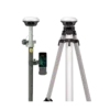
The SingularXYZ Orion One AR Rover Set is a compact RTK GNSS rover solution built for surveyors, construction teams, GIS crews and field engineers who want faster stakeout with visual guidance. Its AR camera view helps users find points directly in the field, while full constellation GNSS tracking, 60° IMU tilt compensation and rugged IP67 protection support reliable daily work on construction sites, roads, utilities and mapping projects.
SingularXYZ Orion One AR Rover Set Highlights
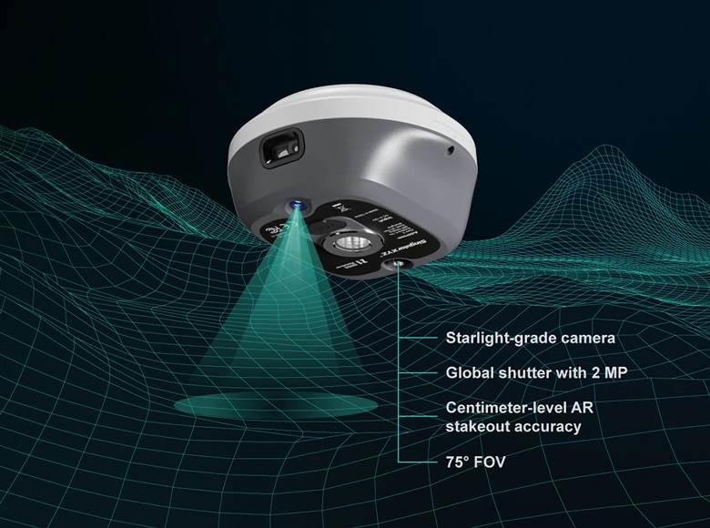
| AR Visual Stakeout | 2MP starlight-grade camera with 75° field of view |
|---|---|
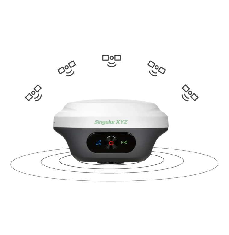
| GNSS Tracking | 1408 channels with GPS, GLONASS, Galileo, BDS, QZSS, NavIC and SBAS support |
| RTK Accuracy | 8 mm + 1 ppm horizontal and 15 mm + 1 ppm vertical |
| Tilt Surveying | IMU tilt support up to 60° |
| Rugged Field Design | IP67 rated, 547 g receiver, up to 12 hours working time |


Valued customers:


Find RTK Networks
Search NTRIP providers and connect to reliable RTK correction services.
Description
SingularXYZ Orion One AR Rover Set for visual RTK surveying
The SingularXYZ Orion One AR Rover Set is made for field teams who need accurate GNSS positioning with a simpler, more visual way to stake out points. Instead of relying only on arrows, distances and numbers on a controller screen, the Orion One AR uses a built-in camera to guide the user toward the point in the real-world view. This makes stakeout easier to understand for experienced surveyors and also more approachable for construction workers or field crews who do not use GNSS equipment every day.
For land surveying, construction layout, road work, utility mapping, GIS data collection and site engineering, the Orion One AR combines RTK GNSS performance with a compact receiver body. The receiver is small enough to carry comfortably during long field days, yet it still includes professional features such as multi-constellation tracking, IMU tilt compensation, wireless connectivity and rugged environmental protection.
AR stakeout that helps you find points faster
The main advantage of the Orion One AR is its visual stakeout workflow. The 2MP starlight-grade camera gives the operator a live field view, so stakeout points can be followed more naturally on screen. In practical terms, this helps when setting out building corners, road points, utility positions, boundaries or design points where crews need clear direction without constant interpretation of a traditional map view.
The camera is designed to work in a range of field conditions, including weaker light situations. This is useful for early starts, shaded urban locations, tree-lined areas and busy sites where speed and clarity matter. For teams that regularly perform stakeout, the visual guidance can reduce confusion and help keep the workflow moving.
Reliable GNSS performance in demanding locations
The Orion One AR tracks multiple GNSS constellations and signals, giving the receiver more satellite availability in real-world environments. This is important when working close to buildings, trees, embankments, machinery or other obstructions that can reduce satellite visibility. Better tracking helps the receiver achieve and maintain a stable RTK fixed solution more consistently.
With RTK accuracy specified at 8 mm + 1 ppm horizontally and 15 mm + 1 ppm vertically, the rover is suitable for professional survey and construction tasks where centimetre-level positioning is required. It is a practical choice for crews that need dependable measurements for topographic surveys, construction layout, as-built checks, GIS control points and general site positioning.
60° IMU tilt for faster field measurements
The integrated IMU allows the pole to be tilted up to 60° while still measuring accurately. This is useful when the point is difficult to occupy directly, such as near walls, fences, parked vehicles, road edges, trenches or obstacles on a construction site. Instead of spending extra time trying to hold the pole perfectly vertical, users can measure with a more natural pole angle and keep moving.
For everyday fieldwork, tilt compensation can save time on repetitive point collection and stakeout. It also helps reduce physical strain, especially during long survey sessions or in locations where standing directly above the point is inconvenient or unsafe.
Compact receiver built for daily field use
The Orion One AR receiver has a compact body measuring Φ107 mm × 58.7 mm and weighs approximately 547 g. This makes it easy to carry, mount and operate throughout the day. The IP67-rated housing protects against dust and water, making the rover suitable for outdoor work in changing weather and rough site conditions.
The internal battery supports up to 12 hours of working time, depending on the work mode and field conditions. USB-C charging and data transfer make daily operation straightforward, while the Wi-Fi WebUI allows users to access receiver settings, status information, data storage and file transfer without a complicated setup.
Flexible communication for rover workflows
The SingularXYZ Orion One AR Rover Set supports several connection methods for common survey workflows. Bluetooth can be used with a field controller, Wi-Fi supports WebUI access and data interaction, NFC helps with quick pairing, and USB-C supports charging and data transfer. The receiver also includes UHF capability, with a working range of up to 15 km in optimal conditions when configured with compatible equipment.
This flexibility makes the rover suitable for crews using local RTK networks, CORS/NTRIP corrections or base and rover configurations. For many users, the practical benefit is simple: the same receiver can adapt to different jobs, correction sources and field setups.
Designed for SingularPad field software
The Orion One AR works with SingularPad field surveying software, giving users access to common field functions such as point survey, point stakeout, CAD mapping, road stakeout, area measurement, volume calculation and data export. For surveyors and engineers, this keeps the field workflow connected from measurement to deliverable. For construction and GIS users, it provides a clearer interface for collecting and checking positions on site.
Data can be exported in commonly used formats, helping teams move measurements into CAD, GIS or office processing workflows. This is especially useful for companies that handle mixed projects across surveying, machine control preparation, construction verification and mapping.
Who uses the SingularXYZ Orion One AR Rover Set?
This rover set is a strong fit for professionals who need accurate GNSS measurements but also want a more intuitive field experience. Land surveyors can use it for topographic work, control checks and stakeout. Construction teams can use it to set out points, check levels and verify positions. GIS crews can collect accurate asset locations for utilities, roads, boundaries and infrastructure. Drone pilots and mapping teams can use it for ground control points and checkpoint measurement.
The AR stakeout function is especially useful for teams that want to make layout work easier for mixed-skill crews. It gives the operator visual guidance instead of relying only on technical GNSS readouts, which can help reduce mistakes and speed up field communication.
Buying from Global GPS Systems
Global GPS Systems supplies the SingularXYZ Orion One AR Rover Set for professionals who need practical, accurate and field-ready GNSS equipment. Our team can help you check whether this rover set fits your correction method, controller preference, software workflow and project requirements. That makes it easier to choose a GNSS solution that works for your daily field tasks, not just the specification sheet.
Datasheets & Manuals
Datasheets and manuals
Datasheets
Specifications
Singular XYZ Orion One AR Rover Set Specifications
Product Overview
| Product Name | Singular XYZ Orion One AR Rover Set |
|---|---|
| Receiver Model | Orion ONE-AR GNSS Receiver |
| Product Type | RTK GNSS rover set for surveying and stakeout |
| Primary Applications | GNSS surveying, RTK rover work, visual AR stakeout, tilt surveying, static data collection and CORS/NTRIP field workflows |
| Main Features | Visual AR stakeout, 2 MP starlight-grade camera, full-constellation GNSS tracking, 60° IMU tilt surveying, internal UHF radio, NFC, Wi-Fi, Bluetooth, USB Type-C, built-in Web UI and IP67 rugged protection |
| Field Software | Compatible with SingularPad field surveying software |
| Data Collector | SingularXYZ SC300 data collector |
GNSS Satellite Tracking
| GNSS Channels | 1408 |
|---|---|
| BDS / BeiDou | B1I, B2I, B3I, B1C, B2a, B2b |
| GPS | L1C/A, L1C, L2C, L2P(Y), L5 |
| GLONASS | G1, G2, G3 |
| Galileo | E1, E5a, E5b, E6 |
| QZSS | L1C/A, L1C, L2C, L5 |
| NavIC | L5 |
| SBAS | WAAS, EGNOS, SDCM, BDSBAS, GAGAN |
| L-Band | Supported |
| Cold Start | <30 s |
| RTK Initialization Time | <5 s typical |
| RTK Initialization Reliability | >99.9% |
| Re-Acquisition | <1 s |
Accuracy
| Mode | Horizontal Accuracy | Vertical Accuracy |
|---|---|---|
| Standalone | 1.5 m | 2.5 m |
| DGPS | 0.4 m | 0.8 m |
| Static Post-Processing | 2.5 mm + 0.5 ppm | 5 mm + 0.5 ppm |
| RTK | 8 mm + 1 ppm | 15 mm + 1 ppm |
| PPP | 5 cm | 10 cm |
| AR Stakeout | 8 mm + 1 ppm | 15 mm + 1 ppm |
| SBAS Accuracy | <1.0 m 3D RMS |
|---|---|
| Time Accuracy | 20 ns |
| Tilt Surveying Accuracy | <±2.5 cm within 60° tilt range |
| Tilt Range | Up to 60° |
Visual AR Stakeout and Camera
| Visual Stakeout | Visual AR guidance for real-world stakeout point positioning |
|---|---|
| Sensor Type | Camera |
| Camera Pixel | Global shutter with 2 MP |
| Frame Rate | 30 fps |
| Field of View | 75° |
| Camera Feature | Starlight-grade camera with HD capture in weak-light environments |
Receiver Data Formats and Protocols
| Data Output Formats | NMEA-0183, RINEX 3.02/3.04, Binary Format *.xyz |
|---|---|
| Data Update Rate | 1–50 Hz selectable |
| Correction Data Format | RTCM v3.3 / 3.2 / 3.1 / 3.0 |
| Supported Protocols | Ntrip client, Ntrip server, Ntrip caster, TCP, UDP |
| Static Storage | 8 GB internal storage |
| Storage Expansion | Expandable to 32 GB according to user demands |
Receiver Communication
| Internal UHF Modem | Enhanced internal UHF radio |
|---|---|
| UHF Working Range | Up to 15 km under optimal conditions |
| UHF Frequency Range | 410–470 MHz |
| UHF Protocol TX / RX | LoRa |
| UHF Protocol RX | TRIMTALK, SATEL, TRANSEOT, TRIMMARK3 and other supported protocols |
| UHF Channel Spacing | 25 kHz |
| UHF Transmit Power | 0.5 W–2 W selectable |
| Bluetooth | BT4.0 Dual Mode |
| NFC | Supports NFC connection |
| Wi-Fi | 802.11 a/b/g/n/ac |
| Interface | 1 × USB Type-C interface for data transmission and charging; 1 × SMA connector for UHF antenna |
Receiver User Interaction
| Front Panel Indicators | 3 LED indicators for satellite tracking, differential data transmission and power |
|---|---|
| Power Button | 1 button for power on/off |
| Web UI Access | Accessible via Wi-Fi |
| Web UI Functions | Configuration, status checking, data transfer, data storage and system upgrade |
Receiver Electrical Specifications
| Power Consumption | 1.8 W; varies by work mode |
|---|---|
| Input Voltage | DC 5–15 V |
| Battery Capacity | 4200 mAh |
| Receiver Working Time | Up to 12 hours |
| Receiver Charging Time | Fast charge, approximately 3 hours charging time |
Receiver Physical Specifications
| Receiver Size | Φ107 mm × 58.7 mm |
|---|---|
| Receiver Weight | 547 g |
| Receiver Housing Material | Magnesium-aluminum alloy |
| Receiver Storage | 8 GB internal storage |
Receiver Environmental Specifications
| Working Temperature | -40°C to +65°C |
|---|---|
| Storage Temperature | -55°C to +85°C |
| Humidity | 100% non-condensing |
| Waterproof and Dustproof Rating | IP67 |
| Drop Resistance | Designed to survive a 2 m drop onto concrete |
Work Modes
| Static Measurement Mode | Records static data using internal storage; data downloadable through Web UI |
|---|---|
| Internal Radio Mode | Uses internal UHF radio with working range up to 15 km under optimal conditions |
| PDA CORS Mode | Connects via Bluetooth to access local CORS through a PDA or field controller |
SC300 Data Collector System
| Data Collector Model | SingularXYZ SC300 |
|---|---|
| CPU | 8-core 2.0 GHz |
| Operating System | Android 12 |
| RAM | 4 GB |
| ROM / Internal Storage | 64 GB |
| Camera | 13 MP rear camera |
| Keyboard | QWERTY keyboard |
| Screen | 6-inch HD highlight screen, 5-point capacitive touch screen |
| Screen Resolution | 720 × 1440 pixels |
| Signal Tracking | GPS + BDS + GLONASS |
| Sensors | G-sensor, light sensor, accelerator, NFC, LED flashlight, microphone and speaker |
SC300 Data Collector Physical and Electrical Specifications
| Size | 244.75 × 84.7 × 20.9 mm |
|---|---|
| Weight | 401 g including battery |
| Battery | 7700 mAh |
| Working Time | More than 16 hours working time with screen on |
| Charging | Fast charge, less than 4 hours charging time |
SC300 Data Collector Communication
| Bluetooth | BT5.0 BLE |
|---|---|
| Wi-Fi | IEEE 802.11 a/b/g/n, 2.4 GHz / 5 GHz |
| SIM Slots | 1 × nano SIM card slot; 1 × SIM card slot shared with TF card |
| 4G FDD-LTE Bands | B1, B2, B3, B4, B5, B7, B8, B20, B28 |
| 4G TDD-LTE Bands | B34, B38, B39, B40, B41 |
| WCDMA Bands | B1, B2, B3, B5, B8 |
| GSM Bands | B2, B3, B5, B8 |
| CDMA Bands | BC0, BC1 |
| NFC Protocols | ISO14443A/B, ISO15693 |
| NFC Reading Distance | 0–5 cm |
| TF Card Support | Supports up to 256 GB extended TF card |
| Interface | USB Type-C, supports fast charge and OTG |
| Notifications | Sound, vibration and LED prompt |
SC300 Data Collector Environmental Specifications
| Working Temperature | -20°C to +55°C |
|---|---|
| Storage Temperature | -30°C to +70°C |
| Waterproof and Dustproof Rating | IP67 |
| Shock Resistance | Designed to survive a 1.5 m drop onto concrete |
| Humidity | 95% no condensation |
| Electrostatic Protection | Air discharge ±15 kV, contact discharge ±8 kV |
Set Components and Included Items
| Item | Quantity | Notes |
|---|---|---|
| Orion ONE-AR GNSS Receiver | Not specified | Main GNSS rover receiver listed for this rover set |
| SC300 Data Collector | Not specified | Data collector datasheet supplied with the product listing |
| SingularPad Field Surveying Software | Not specified | Android-based field surveying software referenced for Wi-Fi data interaction and visual stakeout support |
| UHF Antenna / Accessories | Not specified | Receiver includes SMA connector for UHF antenna; exact accessory package is not specified on the product page |
Compatibility and Configuration Notes
| Enhanced UHF Compatibility | The enhanced UHF base is not compatible with normal UHF rovers on the market |
|---|---|
| Optional Normal UHF | Normal UHF is available as an option for compatibility with UHF receivers from other brands; requirements should be clarified before ordering |
| Power Consumption Note | Power consumption varies with different work modes |
| Receiver Storage Note | Storage can be expanded to 32 GB according to user demands |
Specifications and package contents may vary by configuration, region or manufacturer update. Always check the current configuration before ordering.
FAQ
Singular XYZ Orion One AR Rover Set FAQ
Product Overview
What is the Singular XYZ Orion One AR Rover Set?
The Singular XYZ Orion One AR Rover Set is a professional RTK GNSS rover solution designed for land surveying, construction layout, mapping, stakeout, and other high-precision field measurement tasks. It combines full-constellation GNSS tracking, visual AR stakeout, tilt surveying, rugged protection, and field software support in a compact rover package.
Who is the Orion One AR Rover Set designed for?
This rover set is designed for land surveyors, construction layout teams, civil engineers, mapping professionals, GIS users, infrastructure contractors, and field crews who need accurate positioning and efficient stakeout workflows.
Is this a rover-only set?
Yes, this product is the rover set version. It is intended to be used as a GNSS rover with suitable RTK corrections, such as a compatible base station, UHF correction source, or local CORS/NTRIP network.
What makes the Orion One AR different from a standard GNSS rover?
The main difference is its visual AR stakeout capability. The receiver uses a built-in 2MP starlight-grade camera to help users see stakeout guidance in a real-world view, making it easier to locate and mark points in the field.
What industries use this type of GNSS rover?
The Orion One AR Rover Set is commonly used in land surveying, construction, road and infrastructure projects, utilities, cadastral work, GIS data collection, topographic surveys, and general outdoor positioning tasks.
AR Stakeout, GNSS Accuracy and Tilt Surveying
What is AR stakeout?
AR stakeout uses augmented reality guidance to help surveyors locate stakeout points visually. Instead of relying only on a map or directional arrows, the user can view guidance over the real field scene through the connected surveying software.
How does the 2MP starlight-grade camera help during stakeout?
The 2MP starlight-grade camera provides a wide visual view for AR stakeout and helps users identify the target location more intuitively. It is designed to support clearer visuals even in weak light conditions.
What GNSS constellations does the Orion One AR support?
The Orion One AR supports full-constellation GNSS tracking, including GPS, GLONASS, Galileo, BeiDou, QZSS, NavIC, SBAS, and L-band support. This helps improve positioning reliability in demanding field environments.
How accurate is the Orion One AR in RTK mode?
In RTK mode, the Orion One AR is specified at 8 mm + 1 ppm horizontal accuracy and 15 mm + 1 ppm vertical accuracy under suitable conditions. Actual results depend on satellite visibility, correction quality, environment, and field procedure.
Does the Orion One AR support tilt surveying?
Yes, the receiver includes a high-performance IMU and supports tilt surveying up to 60 degrees. This allows users to measure points more efficiently when the pole cannot be held perfectly vertical.
Can the rover be used in difficult GNSS environments?
Yes, the Orion One AR is designed with full-constellation tracking and anti-interference capability to help maintain reliable positioning in challenging environments such as urban canyons, tree cover, and constrained job sites.
Connectivity, Work Modes and Software
What connectivity options does the Orion One AR include?
The Orion One AR includes NFC, Bluetooth, Wi-Fi, USB Type-C, and an internal UHF radio. These options support field controller connection, data transfer, receiver configuration, charging, and correction workflows.
Does the Orion One AR have an internal radio?
Yes, the receiver includes an internal UHF radio. Under optimal conditions, the radio can support a working range of up to 15 km, depending on environment, antenna setup, terrain, interference, and base configuration.
Can the Orion One AR connect to CORS or NTRIP networks?
Yes, the rover can be used with CORS or NTRIP correction services through a compatible field controller or PDA connection. This allows users to work without setting up their own local base station when network corrections are available.
What work modes does the rover support?
The Orion One AR supports multiple work modes, including static measurement, internal radio mode, and PDA CORS mode. This gives surveyors flexibility for different field workflows and project requirements.
How much onboard storage does the receiver have?
The receiver includes 8 GB of onboard storage for data such as static measurements. Data can be managed and downloaded through the built-in WebUI when connected via Wi-Fi.
What software is used with the Orion One AR Rover Set?
The rover set is designed to work with SingularPad Field Surveying Software, an Android-based professional field surveying platform. SingularPad supports field surveying workflows, Wi-Fi data interaction, and visual stakeout functions when paired with the Orion One Series.
Durability, Power and Field Use
Is the Orion One AR waterproof and dustproof?
Yes, the Orion One AR has an IP67 rating, which means it is built to resist dust and water exposure during demanding outdoor fieldwork.
How rugged is the receiver?
The receiver has a rugged magnesium-aluminium alloy housing and is designed for outdoor surveying environments. It is also specified to survive a 2 m drop onto concrete under stated test conditions.
How large and heavy is the Orion One AR?
The receiver has a compact palm-sized design measuring approximately Φ107 mm × 58.7 mm and weighs about 547 g, making it easy to carry during long days in the field.
How long does the battery last?
The Orion One AR includes a 4200 mAh battery with up to 12 hours of working time. Battery life can vary depending on the selected work mode, radio use, temperature, and field conditions.
How long does it take to charge the receiver?
The receiver supports fast charging and has an approximate charging time of 3 hours. It uses a USB Type-C interface for charging and data transmission.
What temperatures can the Orion One AR operate in?
The receiver is specified for operation from -40°C to +65°C and storage from -55°C to +85°C, making it suitable for a wide range of outdoor surveying environments.
Is the Orion One AR Rover Set suitable for daily professional fieldwork?
Yes, the rover set is built for daily professional use, with RTK accuracy, AR stakeout, 60° tilt support, rugged IP67 protection, multiple correction options, and field software integration for efficient surveying workflows.
Reviews (0)
Only logged in customers who have purchased this product may leave a review.
Reviews
There are no reviews yet