
 GPS & GNSS
 Lidar scanning
 Total Station
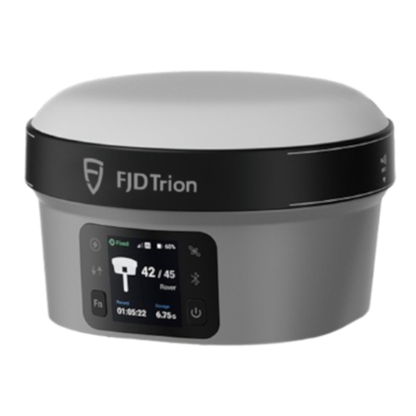
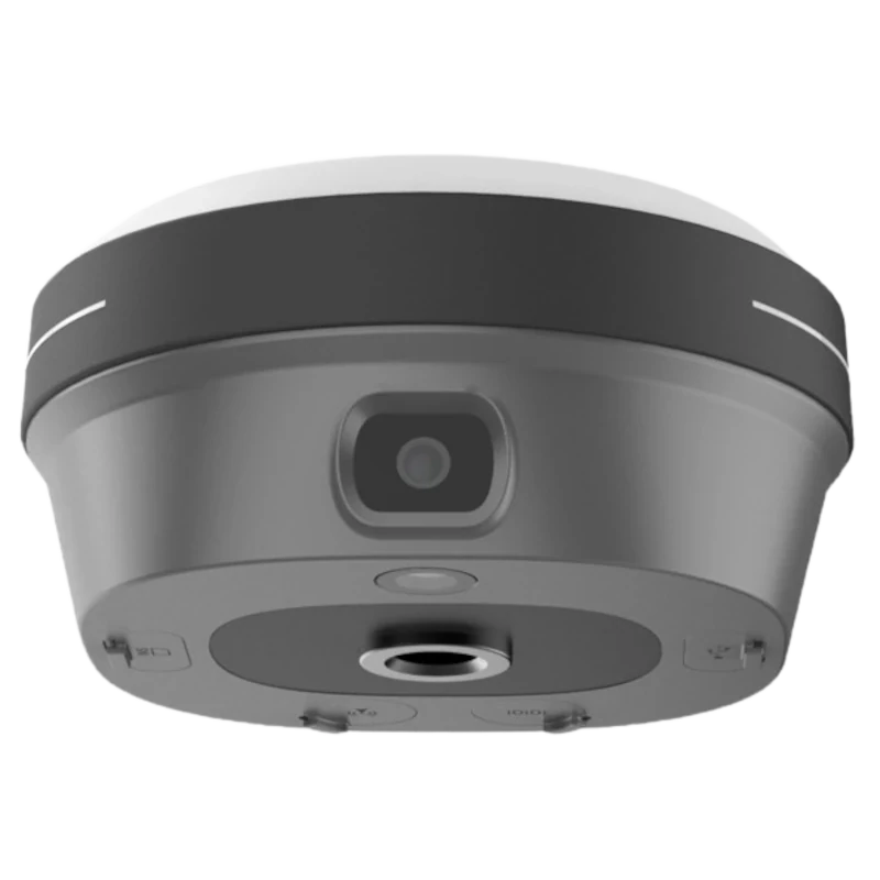
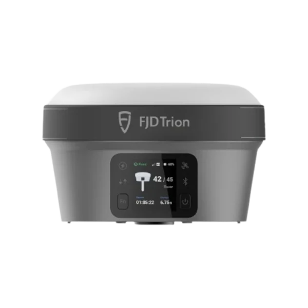


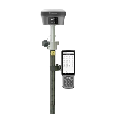
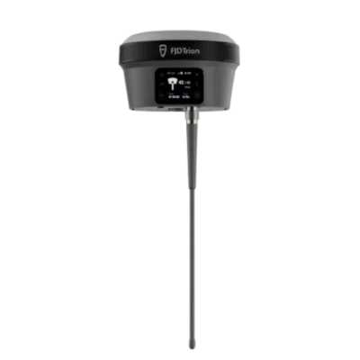
FJD Trion V10i Visual RTK GNSS Receiver with IMU
This product is available
Get the best price for your setup
Contact our experts for the best possible price and configuration.
Its 2 MP forward camera and 5 MP downward camera support live visual guidance and image-based coordinate measurement. A 1408-channel GNSS board tracks multiple satellite constellations, while built-in 4G, UHF, Wi-Fi, Bluetooth and NFC provide flexible access to network RTK corrections, radio links and field controllers.
FJD Trion V10i Highlights
| Visual positioning | AR Stakeout and Visual Measure with 2 MP forward and 5 MP downward cameras |
|---|---|
| IMU tilt survey | Calibration-free tilt compensation up to 60° |
| RTK accuracy | 8 mm + 1 ppm horizontal and 15 mm + 1 ppm vertical RMS |
| GNSS tracking | 1408 channels with GPS, GLONASS, Galileo, BeiDou, QZSS and SBAS |
| Field durability | IP68 rated and designed to survive a 2 m pole drop |

Valued customers:










Find RTK Networks
Search NTRIP providers and connect to reliable RTK correction services.
Description
FJD Trion V10i RTK GNSS Receiver with Visual Positioning
The FJD Trion V10i combines high-accuracy RTK GNSS, IMU tilt compensation and camera-based measurement in one compact field receiver. It is designed for surveyors, construction professionals, engineers, GIS teams, utility crews and drone mapping operators who need dependable centimetre-level positioning without slowing down at awkward, obstructed or difficult-to-access points.
In everyday fieldwork, the V10i can be used as an RTK rover for point collection, topographic surveys, construction layout, cadastral work, utility mapping, road and bridge projects, control surveys and general GIS data capture. Its visual functions provide an additional way to measure and navigate when a conventional pole position is inconvenient or unsafe.
Visual Measure for Hard-to-Reach Points
Visual Measure uses the receiver’s forward and downward cameras together with GNSS and IMU data to calculate the coordinates of a selected point from captured imagery. This is useful where the pole tip cannot be placed directly on the feature, such as across a ditch, beside moving traffic, near an excavation, behind a barrier or on a building edge.
The manufacturer specifies typical visual survey accuracy of approximately 3 cm over a working range of 2 to 15 metres. Actual results depend on site geometry, image quality, satellite conditions and correct field procedure, but the feature can reduce the need to physically enter difficult locations.
AR Stakeout with Live Visual Guidance
AR Stakeout overlays positioning guidance on the live camera view. Instead of relying only on arrows, distances and numerical values, the operator can see the direction of the design point within the real surroundings.
This makes point navigation easier to understand for experienced surveyors and construction workers who do not perform stakeout work every day. It can help reduce unnecessary walking and make it quicker to approach the correct location before completing the final precise positioning step.
Calibration-Free IMU Tilt Compensation
The integrated IMU supports pole tilt angles up to 60 degrees. The survey pole therefore does not need to remain perfectly vertical for every observation, allowing the operator to measure beside walls, under vehicles, near fences, around stockpiles and on uneven ground more comfortably.
The tilt sensor is designed to work without a repeated manual calibration routine and is resistant to magnetic disturbance. This is practical on construction and infrastructure sites where steel structures, vehicles, tools and machinery may interfere with conventional magnetic tilt systems.
Multi-Constellation GNSS Tracking
A 1408-channel GNSS engine tracks signals from GPS, GLONASS, Galileo, BeiDou, QZSS and SBAS. Tracking multiple constellations and frequencies gives the receiver access to more satellites across the sky, which can improve availability and positioning stability when working near buildings, trees or other partial obstructions.
Under suitable RTK conditions, the specified accuracy is 8 mm + 1 ppm horizontally and 15 mm + 1 ppm vertically. The receiver supports update rates up to 20 Hz and is suitable for both routine point collection and workflows where responsive position updates are important.
Flexible RTK Correction Connections
The V10i includes an integrated 4G modem and UHF radio. It can receive corrections from an NTRIP or CORS network through a SIM card, or communicate with a local GNSS base station over radio. Wi-Fi, Bluetooth and NFC are also available for connection to field controllers and other supported devices.
This communication flexibility allows crews to use the receiver in different project environments. A surveyor may connect to a regional RTK network in one area, then switch to a local base and rover setup on a remote site where mobile data coverage is limited.
Clear On-Receiver Status Information
A 1.41-inch colour OLED display shows receiver status and working information directly on the unit. Physical buttons allow basic functions to be accessed without relying entirely on the field controller, including the setup of base station and static survey modes.
This makes it easier to check the receiver in bright outdoor conditions and provides a straightforward way to confirm operating status during setup. Audio feedback and status indicators further help crews understand what the receiver is doing without repeatedly opening the controller software.
Built for Survey and Construction Sites
The housing is rated to IP68 for protection against dust and water ingress and is designed to survive a two-metre pole drop. The receiver weighs approximately 970 g, making it manageable for full working days on a survey pole while still providing a rugged enclosure for demanding site use.
Its stated operating temperature range supports work in cold and hot field conditions. A waterproof breathable membrane helps limit moisture build-up inside the enclosure when the receiver is used in changing weather and temperature conditions.
Battery Performance for Full Working Days
The built-in 7000 mAh battery provides a specified operating time of up to 15 hours in rover mode, 10 hours in base mode and more than 25 hours during static operation. Battery life varies with temperature, radio use, camera use, network conditions and operating mode.
Support for 30 W power delivery charging helps reduce downtime between jobs. An external 9 to 28 V DC power input is also available for longer base station sessions and other extended field operations.
Who Uses the FJD Trion V10i?
The V10i is suited to professional and practical positioning work across surveying, construction, engineering, infrastructure, utilities, GIS and drone mapping. Land surveyors can use it for control, detail, cadastral and topographic work. Construction teams can use it to locate design points, check site features and complete layout tasks.
Utility and GIS crews can record assets and features with accurate coordinates, while drone operators can measure ground control points and checkpoints for photogrammetry projects. The visual measurement capability is particularly useful for teams that frequently encounter inaccessible edges, hazardous surfaces, trenches or points located beyond physical barriers.
Typical Applications
- Land, cadastral and topographic surveying
- Construction layout and site measurement
- Road, bridge and infrastructure projects
- Utility detection and asset mapping
- GIS field data collection
- Ground control and checkpoints for drone mapping
- Riverbank, coastline and difficult-access surveys
Practical Support from Global GPS Systems
Buying an RTK receiver involves more than comparing accuracy figures. Correction services, coordinate systems, software configuration, radio settings and field workflow all affect how well the equipment performs on a real project. Global GPS Systems can help users select a suitable receiver setup and understand the available options for network RTK, local base stations, controllers and accessories.
This makes the FJD Trion V10i a strong option for teams looking for a versatile visual RTK GNSS receiver that combines conventional pole surveying with tilt measurement, image-based point capture and visual stakeout guidance.
Datasheets & Manuals
Datasheets and manuals
Datasheet
Specifications
FJD Trion V10i Specifications
Product Overview
| Product type | Multi-constellation RTK GNSS receiver with visual positioning |
|---|---|
| Operating modes | RTK rover, RTK base, static surveying, post-processed static, high-precision static, PPK, PPP, code differential, autonomous positioning and SBAS |
| Core technologies | GNSS, calibration-free IMU tilt compensation, dual-camera visual positioning, AR stakeout and integrated wireless communications |
| Typical applications | Cadastral surveying, topographic surveying, construction layout, mapping, river and coastline surveys, roads, bridges and utility infrastructure |
| Controller-free operation | Base-station and static modes can be configured using the receiver display and physical buttons |
GNSS Tracking
| GNSS channels | 1408 |
|---|---|
| GPS signals | L1A, L1C, L2C, L2P and L5 |
| GLONASS signals | L1, L2 and L3 |
| BeiDou signals | B1I, B2I, B3I, B1C, B2a and B2b |
| Galileo signals | E1, E5a, E5b and E6 |
| QZSS signals | L1, L2C, L5 and L6; L6 support may require a firmware update |
| IRNSS / NavIC signals | L5; support may require a firmware update |
| SBAS signals | L1 C/A |
| HAS-PPP signal | Galileo E6 |
| Positioning update rates | 1 Hz, 2 Hz, 5 Hz, 10 Hz and 20 Hz |
Positioning Accuracy
| Positioning Mode | Horizontal Accuracy | Vertical Accuracy |
|---|---|---|
| Real-time kinematic, RTK | 8 mm + 1 ppm RMS | 15 mm + 1 ppm RMS |
| Post-processing static | 2.5 mm + 0.5 ppm RMS | 5 mm + 0.5 ppm RMS |
| High-precision static | 2.5 mm + 0.1 ppm RMS | 3.5 mm + 0.4 ppm RMS |
| PPK | 3 mm + 1 ppm RMS | 5 mm + 1 ppm RMS |
| PPP | ±20 cm RMS | ±40 cm RMS |
| Code differential | 0.4 m RMS | 0.8 m RMS |
| Autonomous | 1.5 m RMS | 2.5 m RMS |
| SBAS | 60 cm | |
RTK Initialization and Signal Acquisition
| RTK initialization time | Less than 5 seconds |
|---|---|
| RTK initialization reliability | Greater than 99.9% |
| Cold-start time to first fix | Less than 20 seconds |
| Hot-start time to first fix | Less than 5 seconds |
| Signal reacquisition | Less than 1 second |
IMU Tilt Compensation
| Tilt sensor | Integrated high-precision IMU |
|---|---|
| Tilt range | 0° to 60° |
| Tilt-compensated RTK accuracy | 8 mm + 0.6 mm per degree of tilt RMS |
| Calibration requirement | Calibration-free operation |
| Magnetic interference resistance | IMU-based tilt sensor is designed to remain unaffected by magnetic disturbances |
| Electronic leveling | Electronic bubble display |
Visual Positioning and Cameras
| Camera system | Dual-camera system with global shutters |
|---|---|
| Forward camera | 2 MP |
| Downward camera | 5 MP |
| Camera field of view | 83° |
| Sensor type | Starlight-grade, global-shutter image sensors |
| Pixel size | 3 μm × 3 μm |
| Visual survey accuracy | Typically 3 cm |
| Visual measurement range | 2 m to 15 m |
| Visual measurement method | Video photogrammetry |
| Maximum image-group capture time | 30 seconds |
| Typical image-group size | Approximately 30 MB |
| AR stakeout | Live camera-based visual guidance for locating and staking points |
| Visual Measure | Determines survey coordinates from captured imagery for hard-to-reach or hazardous points |
| Image processing | Onboard multi-engine processing with a 4-core processor |
Mobile Network and Wireless Connectivity
| Cellular modem | Integrated 4G modem |
|---|---|
| Supported cellular standards | TDD-LTE, FDD-LTE, WCDMA, EDGE, GPRS and GSM |
| SIM type | Nano-SIM |
| Wi-Fi | 2.4 GHz and 5 GHz, IEEE 802.11a/b/g/n/ac |
| Bluetooth | Bluetooth 5.2 and Bluetooth Low Energy |
| NFC | Supported for device pairing |
| Cloud workflow support | Supports field-to-office data transfer and project synchronization through the FJD Trion survey ecosystem |
Built-in UHF Radio
| UHF radio function | Integrated transmit and receive radio |
|---|---|
| Available frequency bands | 410 MHz to 470 MHz or 902 MHz to 928 MHz, depending on regional configuration |
| Transmit power | Up to 2 W |
| Supported radio protocols | TRIMTALK, TRIMMARK III, TT450S, TRANSEOT and Satel 3AS 4FSK |
| Radio link rate | 9,600 bps to 19,200 bps |
| Typical radio range | 6 km to 12 km |
| Maximum stated radio range | Up to 16 km under suitable operating conditions |
| Radio antenna connection | Dedicated UHF antenna port |
Data Formats and Storage
| NMEA data | NMEA-0183 input and output |
|---|---|
| RTCM data | RTCM 3.x input and output; RTCM 2.x input |
| CMR data | CMR input |
| Internal storage | 32 GB |
| Supported data workflows | Real-time corrections, static data logging, post-processing and visual measurement data capture |
Ports and Interfaces
| Multi-function port | 7-pin LEMO connector for data communication and external power |
|---|---|
| USB port | USB Type-C for charging and data transfer |
| UHF antenna port | Dedicated external UHF antenna connection |
| SIM interface | Nano-SIM card slot |
| Microphone | Integrated microphone for voice input |
| Speaker | Integrated speaker for audible feedback |
| Physical controls | Two physical buttons |
| Status indicators | Four LED indicators for power, data, satellite and Bluetooth status |
Display and User Interface
| Display type | True-color OLED |
|---|---|
| Display size | 1.41 inches |
| Display resolution | 320 × 360 pixels |
| Pixel density | 274 ppi |
| Display brightness | 350 nits |
| Displayed information | Receiver status, battery level, satellite status, data-link status, operating mode and configuration information |
| Voice interaction | Integrated microphone and speaker; published speech-recognition accuracy is up to 98% on applicable configurations |
Battery and Power
| Battery type | Built-in rechargeable lithium-ion battery |
|---|---|
| Battery capacity | 7000 mAh |
| Battery voltage | 7.4 V |
| Fast charging | 30 W USB Power Delivery |
| Rover operating time | Up to 15 hours |
| Base operating time | Up to 10 hours |
| Static operating time | More than 25 hours |
| External power input | 9 V to 28 V DC |
| Typical power consumption | Approximately 3 W as a UHF or 4G RTK rover without camera operation |
| Visual stakeout power consumption | Approximately 4.5 W |
Physical Specifications
| Dimensions | 130 mm diameter × 83 mm height |
|---|---|
| Weight | Approximately 970 g |
| Housing | Lightweight rugged alloy body |
| Waterproof membrane | Integrated waterproof and breathable membrane designed to reduce water-vapor ingress |
| Pole mounting | Designed for installation on a standard surveying pole or base-station support |
Environmental and Durability
| Ingress protection | IP68 |
|---|---|
| Dust protection | Dust-tight |
| Water protection | Protected against continuous immersion to a depth of 1 m under specified test conditions |
| Drop resistance | Designed to survive a 2 m pole drop |
| Operating temperature | -30°C to 65°C |
| Storage temperature | -40°C to 70°C |
| Humidity | 95% non-condensing |
| Magnetic interference resistance | Alloy construction and IMU-based tilt technology are designed for reliable use in magnetically disturbed environments |
Integrated Functions
| AR stakeout | Displays real-time visual stakeout guidance through the forward-facing camera |
|---|---|
| Visual surveying | Captures and calculates coordinates for points that are difficult or unsafe to access directly |
| Tilt surveying | Allows measurements with the pole tilted by up to 60° without manual IMU calibration |
| Base-station mode | Can transmit RTK correction data through the built-in UHF radio or supported network links |
| Rover mode | Supports UHF, cellular and network RTK correction workflows |
| Static data collection | Supports conventional static and high-precision static surveying workflows |
| Field-to-office workflow | Supports transfer of field data, project updates, coordinate systems, geoid models and datum-grid information through compatible software services |
Software and Controller Compatibility
| Field software | Compatible with the FJD Trion Survey application and associated FJD Trion field workflows |
|---|---|
| Controller options | Compatible with supported FJD Trion keyboard controllers and tablet controllers |
| Correction sources | Built-in UHF radio, network RTK / NTRIP and compatible external correction sources |
| Firmware-dependent features | Some GNSS signals and functions may require current firmware or vary by regional hardware configuration |
Package and Included Items
| Item | Quantity | Notes |
|---|---|---|
| FJD Trion V10i GNSS receiver | 1 | Main receiver with integrated battery, IMU, display, cameras, cellular modem and UHF radio |
| Charging equipment | Configuration dependent | USB Type-C / USB Power Delivery charging equipment may vary by region and bundle |
| UHF antenna | Configuration dependent | Frequency band must match the regional receiver configuration |
| Transport case | Configuration dependent | Availability depends on the selected receiver, rover or base-rover package |
| Survey pole and mounting accessories | Configuration dependent | May be included in complete rover sets or supplied separately |
| Field controller | Optional | Keyboard controller or tablet controller may be supplied as part of a configured set |
| External radio kit | Optional | Used for extended-range base-station operation where required |
| Tripod, tribrach or base support | Optional | Required for selected base-station and known-point setups |
Specifications and package contents may vary by configuration, region or manufacturer update. Always check the current configuration before ordering.
FAQ
FJD Trion V10i FAQ
Product Overview and Applications
What is the FJD Trion V10i?
The FJD Trion V10i is a professional RTK GNSS receiver that combines multi-constellation satellite positioning, an IMU tilt sensor, dual cameras and visual positioning. It is designed for centimetre-level surveying, mapping and stakeout work.
Who is the FJD Trion V10i designed for?
The V10i is designed for land surveyors, construction teams, civil engineers, GIS professionals, utility contractors, infrastructure crews and other field users who require accurate positioning and efficient data collection.
Which surveying applications can the FJD Trion V10i support?
The receiver can be used for cadastral surveying, topographic surveys, construction layout, road and bridge surveys, utility mapping, GIS data collection, river and coastline surveys, as-built measurements and general engineering work.
Can the FJD Trion V10i be used for construction stakeout?
Yes. The V10i supports point, line, CAD, road, slope and DTM stakeout workflows through compatible FJD Trion Survey software. Its AR Stakeout function can display the target position within a live camera view to help operators navigate to the point.
Can the V10i measure points that are difficult or unsafe to reach?
Yes. The Visual Measure function is intended for points where placing a survey pole directly on the target is difficult, inefficient or unsafe. Examples include points near trenches, traffic, water, fences, walls, slopes and other physical obstacles.
Can the FJD Trion V10i be used for both real-time and post-processed surveying?
Yes. The V10i supports RTK positioning for real-time measurements as well as PPK and static observation workflows for projects that require post-processing.
Accuracy, GNSS and Visual Positioning
What RTK accuracy does the FJD Trion V10i provide?
Under suitable satellite, correction and site conditions, the specified RTK accuracy is 8 mm + 1 ppm RMS horizontally and 15 mm + 1 ppm RMS vertically. Actual field accuracy depends on factors such as satellite visibility, correction quality, baseline length, multipath and the measurement environment.
Which satellite constellations does the FJD Trion V10i track?
The V10i has 1,408 GNSS channels and supports signals from GPS, GLONASS, Galileo, BeiDou, QZSS, IRNSS and SBAS. Support for certain QZSS and IRNSS signals may require an appropriate firmware version.
What is Visual Measure on the FJD Trion V10i?
Visual Measure uses the receiver’s cameras, GNSS observations and processing algorithms to calculate the coordinates of a selected point from captured imagery. The operator captures an image group and then selects the required point within the images.
How accurate is the V10i Visual Measure function?
The specified visual survey accuracy is typically approximately 3 cm over a measurement range of 2 to 15 metres. Results depend on image quality, geometry, lighting, satellite conditions, correction quality and correct operating procedures.
What is AR Stakeout?
AR Stakeout provides real-time visual guidance by showing the target stakeout point in the live camera image. This can make it easier to understand the direction and remaining distance to a point than using numerical values or map arrows alone.
What cameras are built into the FJD Trion V10i?
The receiver has a 2 MP forward-facing camera and a 5 MP downward-facing camera with an 83-degree field of view. The global-shutter camera system supports Visual Measure and AR Stakeout workflows.
Tilt Measurement, Corrections and Connectivity
Does the FJD Trion V10i support tilt compensation?
Yes. Its integrated IMU supports tilt compensation from 0 to 60 degrees, allowing measurements to be taken without holding the survey pole perfectly vertical.
Does the V10i IMU require calibration?
No routine calibration is required for the V10i’s calibration-free IMU tilt measurement. The sensor is also designed to resist magnetic disturbances commonly encountered around vehicles, machinery, steel structures and reinforced concrete.
Does tilt compensation maintain full RTK accuracy?
The specified accuracy with tilt compensation is 8 mm + 0.6 mm per degree of tilt RMS. Accuracy can decrease as the tilt angle increases, so the pole should still be kept as stable as practical during important observations.
Can the FJD Trion V10i connect to an NTRIP correction service?
Yes. The integrated 4G modem and nano-SIM slot allow the V10i to receive network RTK corrections from an NTRIP or CORS service where a compatible subscription and mobile data coverage are available.
Does the FJD Trion V10i have a built-in UHF radio?
Yes. The receiver has an integrated 2 W UHF radio for local base-and-rover correction workflows. Available frequency bands and permitted transmission settings depend on the regional version and local radio regulations.
Can the FJD Trion V10i be used without mobile internet?
Yes. Where mobile data or an NTRIP network is unavailable, the receiver can obtain corrections from a compatible local base station through its UHF radio. It can also collect static or PPK data for later processing.
Which wireless connections are available on the V10i?
The V10i includes 4G mobile connectivity, dual-band 2.4 GHz and 5 GHz Wi-Fi, Bluetooth 5.2 with BLE, NFC pairing and a built-in UHF radio.
Software, Hardware and Field Use
Which field software is used with the FJD Trion V10i?
The receiver is designed to work with the FJD Trion Survey application. Depending on the software version and configuration, it supports point collection, tilt measurements, visual measurements, GIS surveys, PPK observations and multiple stakeout methods.
Which data formats can the FJD Trion V10i use?
The receiver supports common GNSS communication formats including RTCM and NMEA. FJD Trion Survey can also support field import and export formats such as ASCII, DWG, DXF, KML, SHP, RW5 and PDF, depending on the selected workflow and software version.
Is the FJD Trion V10i waterproof and dustproof?
Yes. The V10i has an IP68 ingress-protection rating. It is specified as dustproof and protected against continuous immersion in water to a depth of 1 metre under the defined test conditions.
How durable is the FJD Trion V10i?
The receiver is designed to survive a 2-metre pole drop and operate in demanding outdoor environments. Its specified operating temperature range is from -30°C to 65°C, although battery performance and measurement conditions can vary at temperature extremes.
How long does the FJD Trion V10i battery last?
The built-in 7,000 mAh battery is specified for up to approximately 15 hours in rover mode, 10 hours in base mode and more than 25 hours during static operation. Actual operating time depends on temperature, radio use, camera use, display settings and working mode.
How is the FJD Trion V10i charged?
The receiver supports charging through its USB Type-C connection and is specified for 30 W Power Delivery fast charging. It also accepts an external power input of 9 to 28 V DC for extended field operation.
What are the size and weight of the FJD Trion V10i?
The receiver measures approximately 130 mm in diameter by 83 mm high and weighs approximately 970 grams.
Does the V10i have a built-in display?
Yes. The receiver has a 1.41-inch colour OLED display, four status LEDs, two physical buttons and audio feedback. These features allow users to check receiver status and perform essential mode changes in the field.
Reviews (0)
Only logged in customers who have purchased this product may leave a review.

 GPS & GNSS
 Total Stations
 Data collectors
 Software
 Correction services
 Machine control
 External radio
 Lasers & levellers
 Marine
 Accessories
Reviews
There are no reviews yet