


FJD Trion V4e Rover Set with Laser and IMU Tilt
This product is Available
Contact our experts for the best possible price and configuration.
The FJD Trion V4e Rover Set is a compact RTK GNSS rover for surveyors, construction teams, GIS users, drone pilots and field crews who need accurate positioning without carrying a large receiver. Weighing only 320 g, it combines multi-constellation GNSS tracking, 30° IMU tilt compensation and laser measurement support in a pocket-sized receiver built for everyday fieldwork.
With 1408 channels, fast RTK initialization and IP67 protection, the FJD Trion V4e is well suited for site checks, topographic surveys, boundary work, utility mapping, road surveys and quick point collection on uneven or restricted locations. The rover set does not include an internal internet modem or UHF radio, making it a lightweight choice for workflows using external correction access such as NTRIP through a compatible controller or field setup.
FJD Trion V4e Rover Set Highlights
| GNSS Channels | 1408 channels |
|---|---|
| Satellite Support | GPS, GLONASS, Galileo, BDS, QZSS and SBAS |
| RTK Accuracy | Horizontal ≤0.8 cm + 1 ppm, Vertical ≤1.5 cm + 1 ppm |
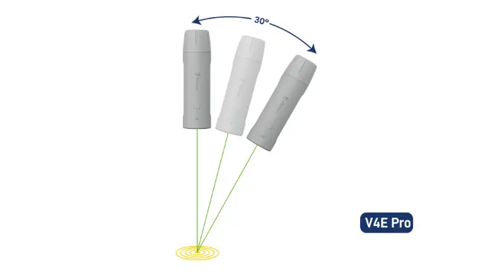
| IMU Tilt | Built-in IMU with up to 30° tilt measurement |
| Laser Measurement | 3D error at 3 m distance ≤3 cm |
| Weight | 320 g |
| Battery Life | 12+ hours, USB C charging in less than 3 hours |
| Rugged Design | IP67 rated with 1.2 m drop resistance |
Valued customers:


Find RTK Networks
Search NTRIP providers and connect to reliable RTK correction services.
Description
FJD Trion V4e Rover Set for Compact RTK Surveying
The FJD Trion V4e Rover Set is made for professionals who want centimeter-level GNSS positioning in a small and easy-to-carry receiver. Instead of working with a heavy rover setup all day, surveyors, construction workers, GIS teams and mapping crews can use the V4e for fast point collection, site checks and accurate field measurements with less equipment in hand.
Its compact 320 g design makes it especially useful for jobs where mobility matters. Crews moving across construction sites, road projects, agricultural fields, public works areas or drone ground control points can quickly collect coordinates without unnecessary weight. The receiver supports 1408 channels and works with GPS, GLONASS, Galileo, BDS, QZSS and SBAS, giving users strong satellite availability across many working environments.
Built for Real Fieldwork
The FJD Trion V4e Rover Set is designed for everyday outdoor conditions. Its IP67-rated housing protects against dust and water, while the 1.2 m drop resistance helps it handle normal jobsite knocks. For long days in the field, the receiver offers more than 12 hours of battery life and can be charged through USB C in less than 3 hours. Charging while in use is helpful for teams working with a power bank during long survey days.
Fast startup and RTK initialization help reduce waiting time on site. Cold start is specified at 30 seconds or less, hot start at 5 seconds or less and RTK initialization at under 5 seconds, depending on field conditions and correction availability. For construction and survey teams, this means less downtime when moving between points or restarting equipment during the day.
IMU Tilt and Laser Measurement for Easier Point Collection
The built-in IMU supports tilt measurement up to 30°, helping users capture points when the receiver cannot be held perfectly vertical. This is useful near walls, fences, obstacles, slopes, trenches and other areas where a straight pole setup is difficult or slower to use.
The laser measurement function adds another practical option for hard-to-reach points. With 3D error at 3 m distance specified at 3 cm or better, users can measure selected points where direct receiver placement is not convenient. This can save time during quick site measurements, object marking and mapping work where accessibility is limited.
Accurate RTK GNSS Performance
The FJD Trion V4e Rover Set delivers RTK accuracy of up to ≤0.8 cm + 1 ppm horizontally and ≤1.5 cm + 1 ppm vertically under suitable conditions. This makes it suitable for professional surveying, construction layout checks, topographic surveys, utility mapping, road surveying, agriculture mapping and GIS data collection.
The rover supports common correction and data formats including RTCM 2.3, RTCM 3.x, CMR and NMEA-0183. This helps the receiver fit into modern RTK workflows where users connect to compatible correction services, software and field controllers. This rover set does not include an internal internet modem or UHF radio, so correction access depends on the chosen field setup, controller or external connection method.
Who Uses the FJD Trion V4e Rover Set?
This rover set is a good match for teams that need reliable GNSS accuracy but prefer a smaller receiver than a traditional full-size RTK rover. Surveyors can use it for fast point collection and topographic work. Construction professionals can use it for site checks, machine guidance preparation, control measurements and as-built data. GIS workers can improve the quality of asset mapping, boundary records and utility location data.
Drone pilots can use the FJD Trion V4e for ground control points and checkpoint measurements, helping improve mapping confidence on photogrammetry or LiDAR projects. Agriculture and landscaping users can also benefit from accurate boundary mapping, field measurement and integration with FJD ecosystem workflows where compatible.
Practical Advantages
- Lightweight 320 g receiver for easier all-day carrying
- 1408 channels for strong multi-constellation GNSS tracking
- 30° IMU tilt support for faster measurements in awkward locations
- Laser measurement support for points that are difficult to reach directly
- IP67 protection and 12+ hour battery life for demanding outdoor work
Designed for Simple and Flexible GNSS Workflows
The FJD Trion V4e Rover Set is especially useful for users who want a practical RTK tool without unnecessary size or complexity. It gives construction workers, surveyors, drone operators and GIS teams a compact way to collect accurate position data in the field. Its open correction format support also makes it easier to fit into different RTK network and controller workflows.
For buyers comparing compact RTK GNSS equipment, the main value of the FJD Trion V4e is the combination of portability, IMU tilt, laser measurement and professional GNSS accuracy. It is not a long-range UHF rover and it does not include an internal modem, but for teams using network RTK or compatible external correction access, it offers a very mobile and practical surveying solution.
Buying from Global GPS Systems
Global GPS Systems supplies GNSS equipment to surveyors, engineers, construction companies, GIS professionals, drone pilots and machine control users worldwide. When choosing the FJD Trion V4e Rover Set, buyers can contact Global GPS Systems for advice about compatibility, RTK network use, field controllers, software workflows and the best setup for their daily work.
Datasheets & Manuals
Datasheets and manuals
Datasheets & manuals
Specifications
FJD Trion V4E Rover Set Specifications
Product Overview
| Product Name | FJD Trion V4E Rover Set |
|---|---|
| Receiver Type | Mini RTK GNSS receiver / rover set |
| Primary Use | Centimeter-level GNSS positioning, surveying, mapping, layout, topographical survey and field data collection |
| Supported Workflows | Rover measurement, RTK correction service connection, base-station protocol connection and FJD ecosystem data workflows |
| Industry Applications | Land surveying, construction, BIM, utilities, public works, road surveying, topographical survey, forestry, agriculture, farming autosteering systems, robotic mower integration and quick robotic integration |
| Design Format | Compact handheld / pole-mountable receiver |
GNSS Constellations and Frequencies
| GNSS Channels | 1408 parallel channels |
|---|---|
| Supported Constellations | BDS, GPS, GLONASS, Galileo, QZSS and SBAS |
| BDS | B1I, B2I, B3I, B1C, B2a, B2b* |
| GPS | L1C/A, L2P, L5 |
| GLONASS | G1, G2 |
| Galileo | E1, E5b, E5a, E6* |
| QZSS | L1, L2, L5 |
| SBAS | L1C/A |
| Firmware-Dependent Signals | BDS B2b and Galileo E6 are supported by specific firmware |
Positioning Accuracy and Reliability
| RTK Accuracy (RMS) | Horizontal: ≤0.8 cm + 1 ppm; Vertical: ≤1.5 cm + 1 ppm |
|---|---|
| Single Point Solution Accuracy (RMS) | Horizontal: ≤1.5 m; Vertical: ≤2.5 m |
| DGPS Accuracy (RMS) | Horizontal: ≤0.4 m; Vertical: ≤0.8 m |
| Static Precision | Centimeter-level, specified up to ±1.5 cm vertical RTK precision |
| Signal Reacquisition | ≤1 s |
| Time to First Fix | Cold start: ≤30 s; Hot start: ≤5 s |
| RTK Initialization Time | <5 s |
| Initialization Data Reliability | >99.9% |
| Data Update Rate | Measurement and positioning: 1 Hz, 2 Hz, 5 Hz, 10 Hz, 15 Hz, 20 Hz |
| Time Accuracy (RMS) | 20 ns |
| Speed Accuracy (RMS) | 0.03 m/s |
Tilt Measurement and IMU
| IMU Tilt Compensation | Up to 30° tilt survey |
|---|---|
| Laser Tilt Measurement Accuracy | 3D error ≤3 cm at 3 m distance measurement, tilt angle ≤30° |
| No-Pole Measurement Support | Supports tilted measurements without holding the receiver perfectly level |
| Laser / IMU Feature Note | Manufacturer documentation identifies laser tilt measurement and 30° IMU tilt survey as V4E Pro features; confirm the exact receiver configuration supplied in the rover set before ordering. |
Correction Data and Data Formats
| Correction Service Connectivity | NTRIP-supported correction workflow via compatible app / network connection |
|---|---|
| Differential Data | RTCM 2.3, RTCM 3.x, CMR |
| Data Format | NMEA-0183 |
| FJD Ecosystem Compatibility | GNSS data can be used with FJD farming autosteering systems, robotic mowers and other compatible FJD smart devices |
| Open Workflow Support | Open design supports customization for specific workflows |
Communication
| Bluetooth | Bluetooth 4.0, dual-mode |
|---|---|
| Bluetooth Working Distance | 5 m |
| Wi-Fi | 2.4 GHz Wi-Fi in base station mode |
| Wi-Fi Working Distance | 300 m using base station protocol |
| Built-in Internet Modem | None |
| Built-in UHF Radio | None |
Power and Electrical Interface
| Charging Input | 5 V / 2 A |
|---|---|
| Power Consumption | ≤1.5 W |
| Electrical Interface | USB 2.0 Type-C |
| Charging Time | ≤3 hours |
| Battery Life | ≥12 hours |
| Charging While Operating | Supported via USB-C / external power bank workflow |
| Charging Temperature | 0°C to 45°C |
Physical Characteristics
| Dimensions | 182 × 53 × 53 mm |
|---|---|
| Weight | 320 g |
| Shell Material | PC + ABS |
| Mounting Interface | 1/4 thread internal interface |
| Button | On / Off key |
| Indicator Lights | Fixed/disassembly indicator light and charging indicator light |
| Satellite / Fix Indicator | Blue flashing when not connected to the app; red flashing when connected but not fixed; solid green after fixed solution |
| Charging Indicator | Red while charging; green when fully charged |
Environmental and Durability
| Operating Temperature | -20°C to 60°C |
|---|---|
| Ingress Protection | IP67 |
| Drop Resistance | 1.2 m anti-drop rating |
| Outdoor Use | Rated for outdoor use; manufacturer advises maintaining waterproofing and placing the device in open outdoor environments for optimal positioning |
Software and App Support
| Mobile App Workflow | Device connection, rover operation, measurement functions, serial port functions and settings via compatible mobile app |
|---|---|
| Survey App | FJD Trion Survey App / professional survey app workflow |
| Supported Mobile Platforms | Android and iOS app download options are referenced in the quick-start manual |
| NTRIP Account Workflow | Fixed solution can be obtained after logging into an NTRIP account or connecting to a base station |
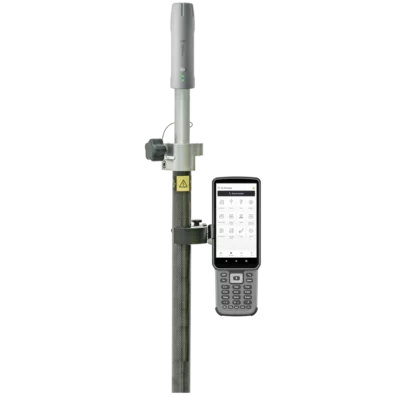
Rover Set Configuration
| Item | Quantity | Notes |
|---|---|---|
| FJD Trion V4E Mini RTK Receiver | 1 | Main GNSS rover receiver |
| Survey Pole | 1 | Rover pole shown as part of the rover set configuration |
| Controller / Phone Bracket | 1 | Bracket shown as part of the rover set configuration |
| Data Collector | 1 | Data collector shown as part of the rover set configuration; exact model may vary by supplied configuration |
| USB-C Charging Cable | 1 | Use a matching charging cable and charger with specified parameters |
Operational Notes
| Recommended Charging Accessories | Use matching charging cable and charger with specified 5 V / 2 A parameters |
|---|---|
| Long-Term Storage | Charge to 50%–80%, store in a dry and cool environment, and recharge every two months to help prevent deep discharge |
| Unauthorized Disassembly | Do not disassemble the device; unauthorized disassembly may void the limited warranty |
| Use Environment | For best GNSS positioning, use in open outdoor environments with suitable satellite visibility and correction data access |
Specifications and package contents may vary by configuration, region or manufacturer update. Always check the current configuration before ordering.
FAQ
FJD Trion V4e Rover Set FAQ
Product Use and Applications
What is the FJD Trion V4e Rover Set used for?
The FJD Trion V4e Rover Set is used for high-accuracy GNSS positioning, RTK surveying, mapping, construction layout, infrastructure work, agriculture, forestry, utilities, and general geospatial data collection.
Who is the FJD Trion V4e Rover Set designed for?
It is designed for surveyors, construction professionals, civil engineers, agricultural users, infrastructure teams, public works departments, forestry professionals, and field teams that need portable centimeter-level positioning.
Is the FJD Trion V4e suitable for land surveying?
Yes. The FJD Trion V4e Rover Set is suitable for land surveying tasks such as point collection, topographical surveys, site measurements, boundary-related fieldwork, and general RTK GNSS positioning.
Can the FJD Trion V4e be used for construction and BIM workflows?
Yes. The rover can be used for construction surveying, layout checks, site mapping, and data collection workflows where accurate field coordinates are required for construction or BIM-related projects.
Is the FJD Trion V4e useful for agriculture and smart farming?
Yes. The FJD Trion V4e can support agricultural workflows such as field data collection, boundary mapping, precision farming tasks, and integration with compatible FJD smart farming systems.
Can it be used for road surveying, utilities, and public works?
Yes. The FJD Trion V4e is suitable for road surveying, infrastructure projects, utility mapping, public works measurements, and field data collection where accurate positioning is needed outdoors.
Accuracy, GNSS and RTK Performance
What accuracy can the FJD Trion V4e Rover Set achieve?
The FJD Trion V4e offers centimeter-level GNSS accuracy, with stated RTK precision of up to H ≤ 0.8 cm + 1 ppm horizontally and V ≤ 1.5 cm + 1 ppm vertically under suitable conditions.
How many GNSS channels does the FJD Trion V4e have?
The FJD Trion V4e supports 1408 GNSS channels, helping it track multiple satellite signals for reliable positioning in professional field applications.
Which satellite constellations does the FJD Trion V4e support?
The receiver supports major GNSS constellations including GPS, GLONASS, Galileo, BeiDou, QZSS, and SBAS, giving users broad satellite coverage for field positioning.
Does the FJD Trion V4e support RTK positioning?
Yes. The FJD Trion V4e is an RTK GNSS rover designed for real-time centimeter-level positioning when connected to a suitable correction source.
How fast does the FJD Trion V4e initialize RTK?
The FJD Trion V4e has a stated RTK initialization time of less than 5 seconds under suitable GNSS and correction conditions.
Does the FJD Trion V4e support NTRIP corrections?
Yes. The FJD Trion V4e supports NTRIP correction workflows and common correction formats including RTCM 2.3, RTCM 3.x, and CMR.
Does the FJD Trion V4e have a built-in UHF radio or internet modem?
No. This rover set is listed without a built-in UHF radio and without a built-in internet modem. RTK corrections are typically used through external connectivity or compatible NTRIP correction workflows.
Tilt, Laser Measurement and Field Workflow
What is the IMU tilt compensation used for?
The built-in IMU tilt compensation helps users measure accurately without keeping the receiver perfectly vertical, making fieldwork faster and easier on uneven ground, near obstacles, or in tight spaces.
How much tilt can the FJD Trion V4e compensate for?
The FJD Trion V4e supports tilt compensation up to 30°, allowing users to collect points more efficiently without carefully leveling the pole for every measurement.
Can I measure without using a perfectly level survey pole?
Yes. The IMU tilt function allows measurements while the receiver is tilted, reducing the need to keep the pole perfectly level during every point collection.
What is the laser measurement feature used for?
The laser measurement feature helps users measure points that are hard to reach directly, such as points near obstacles, unsafe areas, corners, edges, or locations where placing a pole is difficult.
How accurate is the laser measurement?
The FJD Trion V4e Pro laser measurement specification states an accuracy of ≤ 3 cm error at 3 m distance when the tilt angle is within 30°.
Is the FJD Trion V4e good for one-person fieldwork?
Yes. Its compact size, low weight, quick startup, tilt compensation, and laser-assisted measurement make it practical for mobile users and one-person field teams that need to collect points efficiently.
Battery, Durability and Connectivity
How much does the FJD Trion V4e weigh?
The FJD Trion V4e weighs approximately 320 g, making it a very lightweight and portable GNSS rover for daily field use.
What is the battery life of the FJD Trion V4e?
The FJD Trion V4e offers 12+ hours of battery life, supporting long field sessions without frequent recharging.
How long does the FJD Trion V4e take to charge?
The stated charging time is ≤ 3 hours, using a USB Type-C connection.
Is the FJD Trion V4e waterproof and dustproof?
Yes. The rover has an IP67 rating, which helps protect it against dust and water exposure during demanding outdoor fieldwork.
Can the FJD Trion V4e handle rough site conditions?
Yes. The receiver is designed for field use, with IP67 protection and stated resistance to drops of up to 1.2 m.
What is the operating temperature range?
The FJD Trion V4e has a stated operating temperature range of -20°C to 60°C, making it suitable for many outdoor working environments.
Reviews (0)
Only logged in customers who have purchased this product may leave a review.


Reviews
There are no reviews yet