


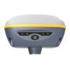
EFIX F7 Compact RTK GNSS Receiver with IMU Tilt
This product is Available
Contact our experts for the best possible price and configuration.
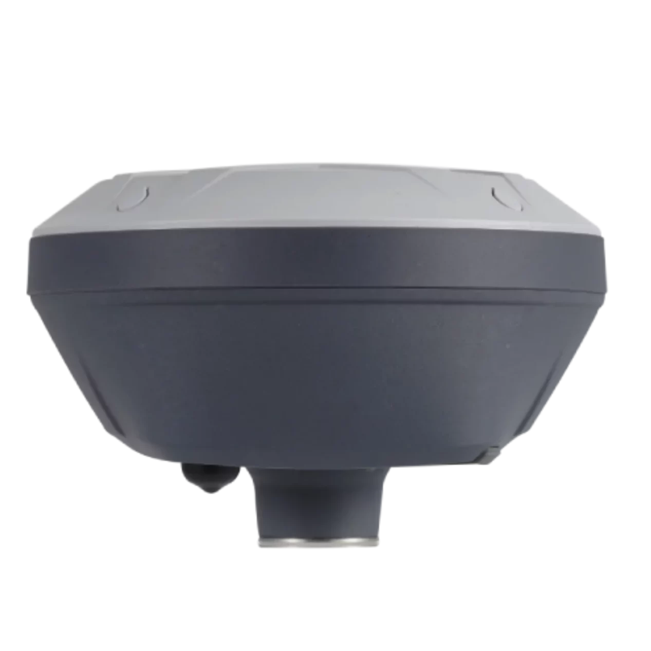
The EFIX F7 is a compact RTK GNSS receiver built for surveyors, construction teams, engineers, GIS users and drone mapping professionals who need reliable centimetre-level positioning in the field. Its palm-size design, IMU tilt compensation and full-constellation tracking make it practical for fast topographic surveys, stakeout, control work and site measurements.
With 1608 channels, an internal UHF radio and a rugged IP67 housing, the EFIX F7 gives field crews a lightweight receiver that is easy to carry without giving up professional RTK performance. The calibration-free IMU helps measure points when the pole is not perfectly level, which is useful around obstacles, road edges, trenches, walls and other difficult positions.
EFIX F7 Highlights
| GNSS Channels | 1608 channels |
|---|---|
| Satellite Support | GPS, GLONASS, Galileo, BeiDou, QZSS, SBAS and PPP |
| IMU Tilt Compensation | Calibration-free IMU with pole-tilt compensation |
| Internal Radio | 410 to 470 MHz UHF Rx/Tx, typical 3 km range |
| Rugged Design | IP67 dust and waterproof, 2 m pole-drop resistance |
Valued customers:


Find RTK Networks
Search NTRIP providers and connect to reliable RTK correction services.
Description
Compact RTK GNSS receiver for everyday fieldwork
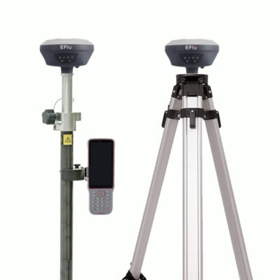
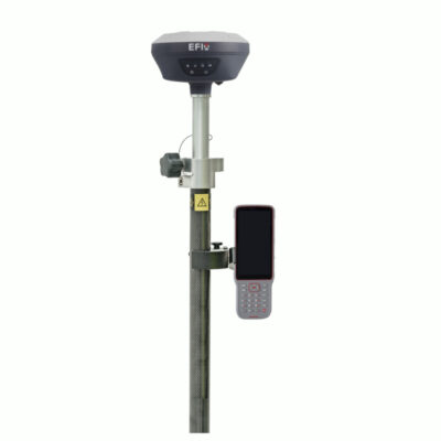
The EFIX F7 is designed for professionals who need accurate GNSS positioning in a compact and practical receiver. It is well suited for land surveying, construction layout, road and utility work, machine control preparation, GIS data collection and drone ground control point measurement. For crews that move between sites or work long days with a rover pole, the lightweight body makes the receiver easier to handle while still offering the performance expected from a professional RTK GNSS system.
Its full-constellation GNSS tracking helps maintain stable positioning by using signals from GPS, GLONASS, Galileo, BeiDou and QZSS. In real field conditions, this gives the receiver more satellite availability, which is especially useful near buildings, trees, slopes, vehicles or other partial obstructions. The advanced RTK engine is built to deliver centimetre-level results when used with suitable correction data and good survey practice.
IMU tilt compensation for faster measuring and stakeout
The EFIX F7 includes calibration-free IMU tilt compensation, allowing users to measure points without keeping the pole perfectly vertical. This is useful when a point is difficult to reach, unsafe to stand over, or blocked by a fence, wall, kerb, trench or material pile. Instead of spending extra time centering the pole for every shot, the operator can work more naturally and keep moving through the job.
For construction workers and surveyors, this can make a clear difference during stakeout and as-built measurements. It reduces the need for repeated pole adjustments and helps maintain productivity when measuring many points across a site. The IMU is also designed to be resistant to magnetic disturbance, making it more dependable around common jobsite objects than basic tilt systems.
Built for survey, construction, GIS and mapping teams
The EFIX F7 is useful for a wide range of field users. Surveyors can use it for topographic surveys, boundary support, control points and stakeout. Construction teams can use it for site layout, checking levels, road work and earthworks preparation. GIS professionals can collect accurate asset positions for utilities, infrastructure, environmental mapping and municipal databases. Drone pilots can use the receiver to establish accurate ground control points for photogrammetry and LiDAR projects.
Because the receiver supports RTK rover workflows, UHF correction links, NTRIP via controller network and static data logging, it can fit into different ways of working. Crews can use it as part of a base and rover setup, connect to an RTK network where available, or record GNSS data for post-processing when the job requires it.
Reliable communication and simple field operation
The integrated UHF radio supports RTK correction communication for base and rover workflows, with adjustable transmission settings to suit different environments. This is helpful for teams working on sites where mobile internet coverage is limited or where a local base station is preferred. The USB Type-C port supports charging, firmware updates and data download, while Wi-Fi and Bluetooth make it easier to connect with controllers and configure the receiver.
The EFIX F7 works with EFIX eField software for survey and engineering tasks. The receiver can also be configured through a web interface using a PC or smartphone over Wi-Fi. For static surveys, logged GNSS data can be downloaded for post-processing, giving surveyors flexibility when RTK is not the best option.
Rugged design for demanding outdoor work
Field equipment is often used in dust, rain, mud, vibration and busy construction environments. The EFIX F7 is built with a magnesium alloy housing, IP67 protection and resistance to a 2 metre pole drop. This makes it suitable for regular outdoor use on construction sites, roads, farms, quarries and survey projects where equipment needs to be both portable and durable.
The receiver also includes a built-in high-capacity battery with long operating time in RTK rover mode. For long field days, the ability to charge through USB Type-C and use a mobile power source helps reduce downtime and makes the receiver easier to manage between jobs.
Why buy the EFIX F7 from Global GPS Systems
Global GPS Systems supplies GNSS equipment to surveyors, construction professionals, GIS teams and mapping specialists worldwide. When choosing an RTK receiver, practical support matters as much as the hardware. Buyers often need help checking compatibility with controllers, RTK networks, radios, field software and the type of work they plan to do.
With the EFIX F7, Global GPS Systems can help you select the right configuration for your workflow, whether you need a rover, a base and rover set, accessories, field software or support with RTK corrections. This makes the receiver a strong option for professionals who want a compact, capable and practical GNSS system for accurate field measurement.
Datasheets & Manuals
Datasheets and manuals
Specifications
EFIX F7 RTK GNSS Receiver Specifications
Product Overview
| Product Name | EFIX F7 RTK GNSS Receiver |
|---|---|
| Product Type | Palm-size GNSS + IMU RTK receiver |
| Primary Applications | Land surveying, construction layout, engineering, mapping, stakeout, GNSS rover and base workflows |
| Positioning Technology | GNSS RTK with integrated calibration-free IMU tilt compensation |
| Receiver Variant Note | The product page is listed as EFIX F7; the linked current datasheet identifies the receiver as F7+. Some specifications may vary between F7 and F7+ configurations. |
GNSS Performance
| GNSS Channels | 1608 channels according to the linked F7+ datasheet; older F7 datasheet lists 824 channels |
|---|---|
| GPS Signals | L1C/A, L2C, L2P(Y), L5 |
| GLONASS Signals | L1, L2 |
| Galileo Signals | E1, E5a, E5b, E6* |
| BeiDou Signals | B1I, B2I, B3I, B1C, B2a, B2b |
| QZSS Signals | L1, L2, L5, L6* |
| PPP Signal | B2b-PPP |
| SBAS Signals | L1, L2 |
| Positioning Rate | 1 Hz, 5 Hz and 10 Hz |
| Time to First Fix | Cold start: < 45 s; hot start: < 10 s; signal re-acquisition: < 1 s |
GNSS Accuracy
| RTK Accuracy | Horizontal: 8 mm + 1 ppm RMS; vertical: 15 mm + 1 ppm RMS |
|---|---|
| RTK Initialization Time | < 10 s |
| RTK Initialization Reliability | > 99.9% |
| PPK Accuracy | Horizontal: 3 mm + 1 ppm RMS; vertical: 5 mm + 1 ppm RMS |
| Static Post-Processing Accuracy | Horizontal: 2.5 mm + 0.5 ppm RMS; vertical: 5 mm + 0.5 ppm RMS |
| Code Differential Accuracy | Horizontal: 0.4 m RMS; vertical: 0.8 m RMS |
| Autonomous Accuracy | Horizontal: 1.5 m RMS; vertical: 3.0 m RMS |
| RTK Tilt Compensation Accuracy | Additional horizontal pole-tilt uncertainty typically less than 10 mm + 0.7 mm/° tilt |
| Accuracy Conditions | Accuracy specifications assume open sky, low multipath, optimal GNSS geometry, suitable atmospheric conditions and recommended GNSS field practices. |
IMU Tilt Compensation
| Tilt Sensor | Calibration-free IMU for pole-tilt compensation |
|---|---|
| Magnetic Disturbance Resistance | Immune to magnetic disturbance |
| Tilt Compensation Benefit | Allows measurements when the pole is not perfectly plumb, improving survey and stakeout productivity |
| Tilt Range | Product page lists IMU tilt sensor up to 60° |
Communication and Data Recording
| Wi-Fi | 802.11 b/g/n, access point mode |
|---|---|
| Bluetooth | Bluetooth v4.1 |
| Data Storage | 8 GB high-speed internal memory |
| USB Port | 1 x USB Type-C port for data download, charging and firmware update |
| UHF Antenna Port | 1 x UHF antenna port, TNC female |
| Internal Internet Modem | None |
| NTRIP Support | NTRIP Client on PDA/controller network |
| Web Configuration | Receiver configuration available through web browser interface |
UHF Radio
| Radio Type | Internal UHF radio |
|---|---|
| Frequency Range | 410 – 470 MHz on linked F7+ datasheet; product page additional information lists 430 – 470 MHz |
| Transmit Power | 0.5 W and 1 W |
| Radio Protocols | EFIX, Transparent, TT450, Satel; product page also lists CHC and TrimTalk450s |
| Typical Radio Range | Typical 3 km, up to 8 km under optimal conditions |
| Link Rate | 9,600 bps |
| Included UHF Antenna | UHF whip/bar antenna, 410 – 470 MHz or 450 – 470 MHz depending on kit listing |
Supported Data Formats
| CMR | CMR input and output |
|---|---|
| RTCM | RTCM 2.x and RTCM 3.x input and output |
| NMEA | NMEA 0183 output |
| Static / Raw Data Formats | HCN, HRC and RINEX static formats |
| Network Corrections | NTRIP Client on PDA/controller network |
Electrical and Power
| Power Consumption | 2.2 W depending on user settings on linked F7+ datasheet; older F7 datasheet lists 4 W depending on user settings |
|---|---|
| Battery Type | Built-in non-removable Li-ion battery |
| Battery Capacity | 6,800 mAh |
| External Power | 5 V / 2 A |
| Charging | USB Type-C charging; supports charging from a mobile power bank |
Operating Time
| Mode | F7+ Linked Datasheet | Older F7 Datasheet |
|---|---|---|
| RTK Rover | Up to 24 h | 12 h |
| UHF RTK Base | Up to 10.5 h | Not specified |
| Static | Up to 25 h | Up to 15 h |
| Battery Life Note | Battery life is subject to operating temperature, radio use and receiver settings. | |
Hardware and Physical Specifications
| Dimensions | 119 mm x 119 mm x 85 mm / 4.7 in x 4.7 in x 3.3 in |
|---|---|
| Weight | 0.77 kg / 1.60 lb according to datasheets; product page description lists approximately 0.73 kg |
| Housing | Magnesium alloy housing |
| Front Panel | 4 status LEDs and 2 buttons |
| Design | Compact palm-size receiver body |
Environmental and Durability
| Ingress Protection | IP67 dust and waterproof; protected from temporary immersion to 1 m depth |
|---|---|
| Shock Resistance | Survives a 2 m pole drop |
| Operating Temperature | -40 °C to +65 °C / -40 °F to +149 °F |
| Storage Temperature | -40 °C to +85 °C / -40 °F to +185 °F |
| Humidity | 100% condensation |
Certifications and Standards
| Certifications | CE; MIL-STD-810H |
|---|---|
| Radio Licensing Note | Use of UHF radio may require local authorization or operator licensing depending on country or region. |
Software and Configuration
| Field Software | Compatible with EFIX eField survey software |
|---|---|
| Controller Connection | Wi-Fi or Bluetooth connection to controller with eField software |
| Data Download Methods | FTP download, web server download and USB download |
| Firmware Update | Firmware update supported through receiver interface / USB Type-C connection |
Package / Included Items
| Item | Quantity | Notes |
|---|---|---|
| EFIX F7 GNSS receiver | 1 | Main GNSS RTK receiver |
| UHF whip / bar antenna | 1 | Frequency range depends on kit listing; product page lists 450 – 470 MHz and manual lists 410 – 470 MHz |
| 2 m range pole with bag | 1 | Included in rover kit listing |
| USB Type-C cable | 1 | For charging, data download and firmware update |
| Auxiliary H.I. tool | 1 | Height measurement accessory |
| Power adapter | 1 | For charging the receiver |
| Transport hard case | 1 | Hard case for F7 rover kit transport and storage |
| Tribrach adapter | 1 | Listed in the F7 user guide basic rover kit supply; verify current package configuration |
Specifications and package contents may vary by configuration, region or manufacturer update. Always check the current configuration before ordering.
FAQ
EFIX F7 FAQ
Product Overview
What is the EFIX F7 used for?
The EFIX F7 is a professional RTK GNSS receiver used for high-accuracy land surveying, construction layout, mapping, GIS data collection, road work, utility mapping and other field positioning tasks that require reliable centimeter-level results.
Is the EFIX F7 a GPS receiver or a GNSS receiver?
The EFIX F7 is a GNSS receiver. Unlike a basic GPS-only receiver, it can track multiple satellite constellations, including GPS, GLONASS, Galileo, BeiDou and QZSS, helping improve availability and reliability in the field.
Who is the EFIX F7 designed for?
The EFIX F7 is designed for land surveyors, civil engineers, construction contractors, mapping professionals, GIS teams, infrastructure companies and utility survey crews that need accurate and efficient field measurements.
Can the EFIX F7 be used for construction layout?
Yes. The EFIX F7 can be used for construction stakeout and layout work when paired with suitable field software, a compatible controller and the correct RTK correction setup.
Can the EFIX F7 be used for GIS mapping?
Yes. The EFIX F7 is suitable for high-precision GIS mapping and data collection, including collecting points, lines, attributes and field information for mapping and asset documentation workflows.
What is included with the EFIX F7 package?
The EFIX F7 package typically includes the F7 GNSS receiver, UHF whip antenna, 2 m range pole, USB Type-C cable, auxiliary height tool, power adapter and transport hard case.
Accuracy and GNSS Performance
How accurate is the EFIX F7?
The EFIX F7 is built for centimeter-level RTK positioning. Actual accuracy depends on satellite visibility, correction quality, site conditions, multipath, atmospheric conditions and correct field procedures.
Which satellite constellations does the EFIX F7 support?
The EFIX F7 supports GPS, GLONASS, Galileo, BeiDou and QZSS satellite constellations, giving surveyors access to a broad range of GNSS signals for more stable positioning.
How many GNSS channels does the EFIX F7 have?
The EFIX F7 is listed with 1608 GNSS channels, allowing it to track many satellite signals and support reliable positioning performance in professional survey workflows.
Does the EFIX F7 support RTK surveying?
Yes. The EFIX F7 supports real-time kinematic surveying for centimeter-level positioning when connected to suitable RTK corrections from a base station or correction network.
Can the EFIX F7 be used for PPK or static surveying?
Yes. The EFIX F7 can be used for post-processing workflows such as PPK and static data collection, depending on the project setup, field software and processing workflow used.
What field conditions can affect EFIX F7 accuracy?
Accuracy can be affected by poor satellite geometry, obstructions, trees, buildings, reflective surfaces, weak correction data, incorrect antenna height, unstable pole setup or improper field configuration.
IMU Tilt Compensation and Field Productivity
Does the EFIX F7 have IMU tilt compensation?
Yes. The EFIX F7 includes an IMU tilt sensor for pole-tilt compensation, helping users measure points without always keeping the pole perfectly vertical.
What does the IMU tilt sensor do?
The IMU tilt sensor compensates for pole tilt during measurement. This helps improve productivity when measuring hard-to-reach points, corners, walls, obstacles or locations where centering the pole is difficult.
Does the EFIX F7 IMU need calibration?
The EFIX F7 uses a calibration-free IMU for pole-tilt compensation, making it easier to start fieldwork quickly and reducing setup steps during normal surveying tasks.
Is tilt compensation useful for stakeout?
Yes. Tilt compensation can make stakeout faster and easier because the receiver can still produce accurate measurements when the pole is tilted within the supported range and used correctly.
Can the EFIX F7 help measure difficult or unsafe points?
Yes. IMU tilt compensation can help surveyors capture points that are close to walls, fences, edges, slopes, traffic areas or other obstacles where placing the pole directly over the point is difficult.
Does the EFIX F7 improve survey speed?
The EFIX F7 is designed to improve field efficiency by combining RTK positioning, multi-constellation GNSS tracking and IMU tilt compensation, reducing the time spent leveling the pole and measuring difficult points.
Connectivity, Durability and Workflow
Does the EFIX F7 have an internal internet modem?
No. The EFIX F7 does not have an internal internet modem. For network RTK workflows, corrections are typically received through the connected controller or data collector.
Does the EFIX F7 have an internal UHF radio?
Yes. The EFIX F7 includes an internal UHF radio, making it suitable for base-rover workflows where RTK corrections are transmitted by radio.
Can the EFIX F7 use NTRIP corrections?
Yes. The EFIX F7 can be used with NTRIP correction workflows through a compatible controller or field software connection, depending on the correction service and setup.
Is the EFIX F7 waterproof?
The EFIX F7 has an IP67 rating, meaning it is protected against dust and temporary water immersion under specified conditions, making it suitable for demanding outdoor fieldwork.
How rugged is the EFIX F7?
The EFIX F7 is built with a rugged field-ready design and is specified to survive a 2 m pole drop, helping protect the receiver during demanding survey and construction use.
What software can be used with the EFIX F7?
The EFIX F7 is commonly used with eField survey software for tasks such as point survey, continuous survey, IMU survey, stakeout, mapping, road work, CAD workflows and pipeline surveying.
What data formats are supported in EFIX field workflows?
EFIX field workflows can support common surveying and mapping formats such as points, CAD data, SHP, DXF, KML, KMZ, CSV, TXT, RINEX and other export formats depending on the software and project setup.
Reviews (4)
4 reviews for EFIX F7 Compact RTK GNSS Receiver with IMU Tilt
| 5 star | 100% | |
| 4 star | 0% | |
| 3 star | 0% | |
| 2 star | 0% | |
| 1 star | 0% |
Only logged in customers who have purchased this product may leave a review.
Pedro s. (verified owner) –
Colleague use this receiver as well, i like
Louis Moreau (verified owner) –
Good smal receiver
Oskar Nordström (verified owner) –
I’m very happy with this receiver. They helped me find the receiver that was best for me.
Dennis Kuipers (verified owner) –
Snelle verbinding, tilt sensor werkt geweldig.