Alpha 400 Rover set Product Review
Below you will find a complete overview of the Alpha 400 Rover set.
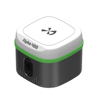
Alpha 400 Rover Set – Advanced GNSS Rover for Professional Surveying Excellence
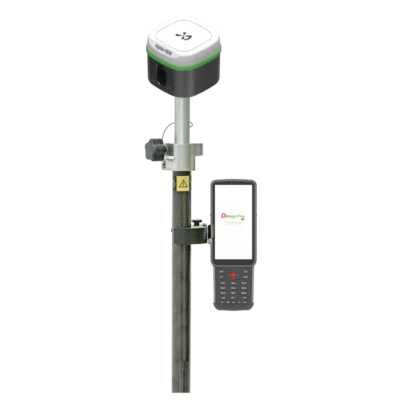
The Alpha 400 Rover set is an advanced, high-precision GNSS rover system designed for professional surveyors who demand speed, stability, and accuracy in every measurement. Combining intelligent hardware with powerful data collection and mapping software, the Alpha 400 Rover set delivers unmatched performance across all surveying tasks — from control points to detailed CAD mapping.
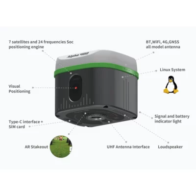
Built with a visual positioning RTK engine, the Alpha 400 Rover integrates GNSS, IMU, and visual data into one seamless solution. It’s powered by a 7-satellite, 24-frequency SoC positioning engine, enabling survey-grade accuracy of 2cm even at a 60° tilt angle. The system automatically activates inertial navigation mode — no initialization needed — allowing you to start measuring immediately.
Revolutionary Visual Positioning with AR Stakeout
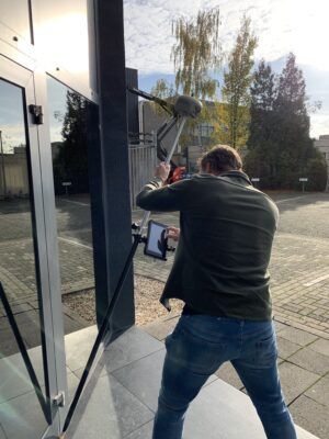
The Alpha 400 Rover set stands out for its AR visual stakeout capability, bringing real-world context into your surveys. Its professional optical lens and high-performance image processing engine let you “see what you measure.” Users can simply tap on the screen to capture accurate coordinate data — even in bright or backlit environments.
With a 360° clear display and 1cm visual stakeout precision, the Alpha 400 Rover transforms how you work in the field. It’s ideal for construction layout, topographic mapping, boundary marking, and infrastructure staking — all while maintaining effortless accuracy and workflow efficiency.

Superior Connectivity and Hardware Design
The Alpha 400 Rover set is engineered with a rugged yet lightweight body that can handle any field condition. It includes:
-
BT, Wi-Fi, 4G, and GNSS antenna for uninterrupted connectivity.
-
Linux operating system offering enhanced customization and stability.
-
Type-C port, SIM card slot, and UHF antenna interface for flexible communication.
-
Loudspeaker for voice feedback and status notifications.
-
Signal and battery indicators for instant monitoring.
Equipped with a 2W internal UHF radio, the Alpha 400 Rover set ensures seamless base-rover communication and compatibility with most surveying networks.
Its battery performance is optimized for the toughest field operations, lasting 18 hours in CORS mode, 15 hours in radio receiving mode, and 8 hours in transmitting mode — keeping you productive all day long.
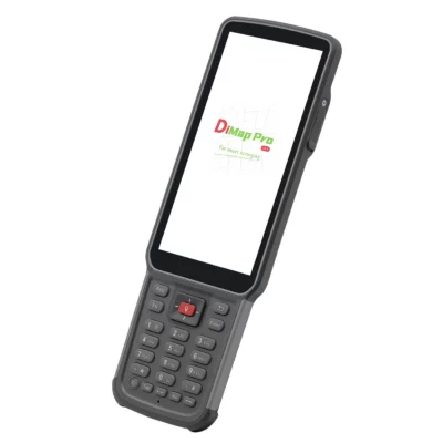
Professional Surveying with the B55 Data Collector and DiMap Pro Software
The Alpha 400 Rover set comes paired with the B55 Data Collector and DiMap Pro software, offering a complete surveying and mapping solution. Together, they streamline everything from point and detail surveys to complex CAD mapping and stakeout operations.
With DiMap Pro’s robust features, users can perform:
-
Point and control point surveys
-
Road and electric line stakeout
-
Polyline and polygon surveys
-
Spiral and photovoltaic stakeouts
-
DSM and electric tower stakeouts
Powered by a stronger CAD engine, DiMap Pro can open files over 100MB smoothly, support multiple layers, and handle full drawing functions. It’s designed for professionals who work with complex geospatial data, offering multi-encoding support, background layer setup, offset correction, and tilt accuracy checks.
Additionally, the software supports Amap and other mapping integrations, post-test correction, and built-in calculations — giving surveyors full control and precision on-site.
5 Key Benefits of the Alpha 400 Rover Set
-
2cm tilt-compensated GNSS accuracy and 1cm AR visual stakeout precision.
-
Complete surveying functionality with B55 Data Collector and DiMap Pro software.
-
Long 18-hour battery life for uninterrupted field productivity.
-
High-performance CAD engine supporting 100MB+ files and multiple layers.
-
Seamless connectivity with BT, Wi-Fi, 4G, and UHF radio communication.
Unmatched GNSS Rover Performance and Accuracy
The Alpha 400 Rover set integrates GNSS, IMU, and visual technologies to provide stable, calibration-free, and real-time positioning data. With photoelectric measuring capability and advanced temperature compensation algorithms, the rover ensures consistent results even under extreme environmental conditions.
Whether you’re surveying remote terrains or managing high-precision construction layouts, the Alpha 400 Rover delivers instant fix solutions, anti-block performance, and high dynamic posture tracking — setting a new standard for professional GNSS rovers.
Why Choose the Alpha 400 Rover Set?
The Alpha 400 Rover set is more than just a GNSS rover — it’s a complete surveying ecosystem. From its intelligent AR stakeout system to the powerful B55 Data Collector and DiMap Pro software, every component is engineered to work seamlessly together.
Surveyors benefit from a faster workflow, real-time visualization, and advanced CAD integration — all in one compact, portable, and reliable system.


 Channels
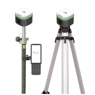


Reviews
There are no reviews yet.