
GNSS, Monitoring
Natural disasters and how to monitor them
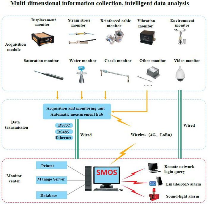
What is SMOS?
SMOS is SOUTH professional deformation monitoring system, it is based on the monitoring sensors, data transmission link and the data monitoring process and analysis center.
The SMOS is compatible with multiple monitoring sensors like GNSS, strain stress sensor, reinforced cable monitor, vibration monitor and environment monitor etc. Various solution for different projects requirement.
Considering the different monitoring project application environment, SMOS supports different links for data transmission—the wired and wireless. The wired transmission could be RS232, RS485 or Ethernet.
The monitoring center is the core software of SMOS, it consist of manage server, database and printer.
SMOS uses rigorous data screening and processing algorithms to ensure the high-precision data from the connected sensors as much as possible. All measurement data and result data are stored in the database. Whether using SMOS or third-party software, these data can be safely accessed locally or remotely for analysis. The system supports a wide range of sensors, and the software is also designed to easily add additional sensors. Combined use of a series of measurements and data collected by geodetic sensors.
The powerful event management system can send relevant information through E-mail, SMS or data interface according to pre-defined rules (such as the measured displacement value exceeds the limit difference, power failure, etc.). During the measurement process, external devices and programs can be controlled by pre-specified events.
The SMOS analyzer can present data graphically and digitally. The results can be displayed in different ways, such as a time series graph, which represents the movement trend over the selected time period. Many points can be represented on one image at the same time. All above information could be output by the printer.
Why users choose South Smos?
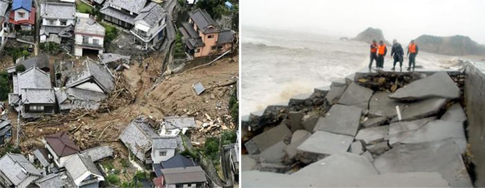
Various accidents occur at any time in every corner of the world due to excessive deformation like Landslip and debris flow, so the deformation monitoring is the best solution for potential risk management
In measurement field, timely and reliable monitoring and deformation analysis is the most challenging refined engineering, because it requires high-precision, high-reliability sensors, fully automatic measurement processing, advanced data communication methods and flexible calculation methods and analysis tools. SOUTH SMOS can meet the above requirements. It is an open, upgradeable and customizable fully automatic monitoring platform. In this platform, various SOUTH measurement products, such as GNSS, inclinometers, strain stress sensors can be integrated. In addition to this, other third-party geological sensor data can also be accepted at the same time. The utility model can be used for the automatic safety monitoring application of external deformation and three-dimensional space position change of structures such as buildings, dams, landslides, mines, bridges, tunnels, and elevated roads.
SOUTH has rich experience in domestic monitoring projects. SMOS monitoring system will renew your mind, and provide the professional and customize monitoring solutions.
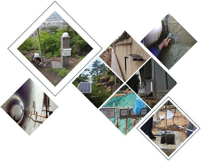
Below you can find 5 user cases on how the South SMOS has been implemented in various projects.
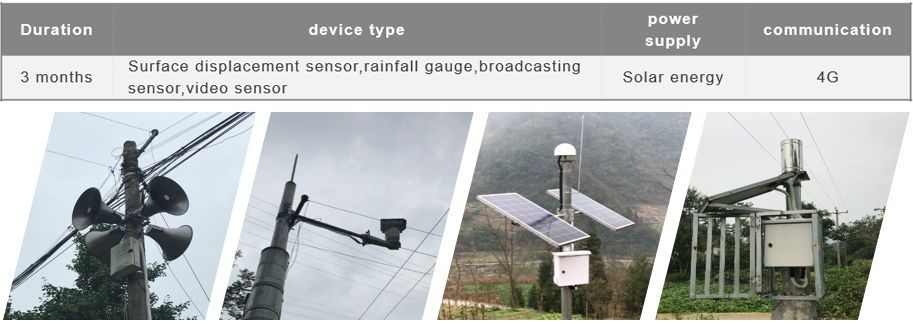
1. Geological Disaster Monitoring (Shanxi, China)
- Project overview
Taking all factors into account, the prevention and control of geological disasters in Shanxi Province is facing a very serious situation. The implementation of the “Internet + Shanxi Land” project is of great significance to the construction of real-time monitoring and early warning systems and emergency platforms for geological disasters in Shanxi. Further deepen the monitoring and fore- warning of geological disasters.
- Solutions
hrough the professional survey and monitoring site design of 6 landslides and 2 debris flow ditches in Linfen, Yuncheng and Luliang areas, nearly 70 sets of integrated professional monitoring equipment were installed.
Develop the platform of geological disaster monitoring and forewarning system, dynamic monitoring is carried out on the geological safety status of potential risk points. The monitoring data is transmitted to the data center, designated mobile communication equipment terminal and wireless fore- warning terminal by means of GPRS and GNSS satellites. Moreover, the monitoring data are stored, managed, searched, counted and analyzed. The monitoring data can reach the warning threshold to realize the forewarning. The forewarning network system of geological disaster monitoring and fore- warning in Shanxi can be built by using the forewarning methods such as mobile phone short message and wireless forewarning radio
- Challenges
Using surface displacement, rainfall, video, ground / infrasound, mud (water) level and other monitoring technologies, remote and automatic real-time monitoring of various physical parameters that induce disasters, and real-time communication with the provincial emergency platform data center. Forewarning analysis is conducted through a professional monitoring and forewarning system, and remote alarm technology is used to promptly issue forewarning information to threatened people near disaster bodies
- Benefits
On July 7, 2017, the Shanxi Provincial Department of Land Resources organized an expert acceptance meeting. The project is a demonstration project and a landmark project of the “Internet + Shanxi Land” information construction of the Shanxi Provincial Department of Land and Resources. The completion of the project will comprehensively enhance Shanxi Province. The information management level of geological disaster prevention provides technical support for disaster prevention and mitigation.
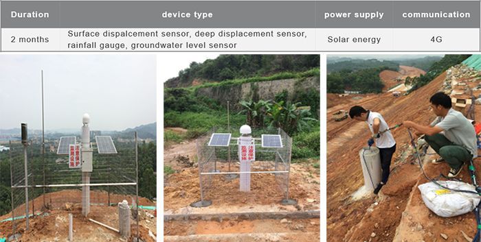
2. Landslide Monitoring (Sichuan, China)
- Project Overview
The monitoring of Emeishan City in Sichuan mainly conducts landslide monitoring on Dawei Town and Jiuli Town with safety risks. The Daweizhen Shuijingwan landslide was confirmed by the site investigation as a basically stable landslide. The landslide at Caokousi in Jiuli Town was significantly displaced at 0:00 on June 13, 2015. Both the original surface displacement monitoring equipment and the deep displacement monitoring equipment were significantly displaced, and the equipment was damaged. On the basis of the first-phase monitoring and early warning work, on the premise of fully considering that two large- scale landslides have occurred in the Caokousi landslide, the original monitoring and forewarning work was supplemented and expanded in a targeted manner.
- Solutions
In this project, 4 GNSS monitoring points, 1 GNSS reference station, 2 rainfall monitoring stations, 1 video monitoring station and 1 broadcasting early warning system were set up in the Jingshuiwan landslide in Dawei town.Two GNSS monitoring stations, one GNSS reference station, one video monitoring station, and one broadcasting system were set up on the landslide in the town of Jiuli.All monitoring data and video can be accessed in real time through the platform and mobile phone, and the broadcasting system can be directly controlled through the software, platform and mobile phone.
- Challenges
This project uses a combination of GNSS and video monitoring to realize the combination of objective data and on-site visual video to observe and analyze each monitoring point. The project implementation process includes the complete process of surveying , project selection, system design, installation and construction, system commissioning, installation and protection. It involves dozens of monitoring equipment for GNSS displacement, broadcasting and video. Targeted customized monitoring and forewarning methods for each monitoring point fully reflect the compatibility, reliability, stability and design and implementation capabilities of the south geological disaster safety monitoring system.
- Benefits
Sending early warning signals to landslide disasters that may occur again can enable villagers to avoid landslide disasters in advance and avoid potential economic losses. The benefits of disaster prevention and mitigation are very significant.
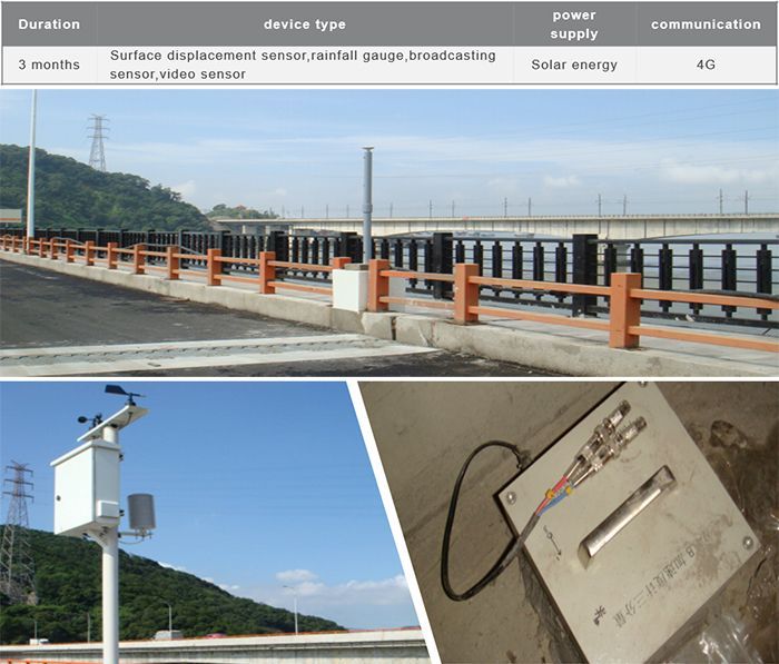
3. Safety monitoring of Bridge ( Fujian, China)
- Project overview
The 324 National Highway Wulongjiang Bridge is located at the lower gorge of Wulong River in Fuzhou City, Fujian Province. It is a large-span prestressed concrete T-shaped rigid frame bridge built earlier in China.
- Solutions
This system adopts various advanced testing instruments to monitor the various responses of the bridge under various external effects (including traffic load, environmental load, etc.), and then processes the monitored information and transmits it to the control center . Engineering technicians will combine the structural model and other knowledge to diagnose the structure, analyze the damage status of the structure, and finally evaluate the health status of the bridge structure, and send forewarning information in due course.
- Project Profile
The basic structure of the structural health monitoring system of the Bridge includes sensor systems, data acquisition and transmission systems, data management systems, bridge structure analysis and forewarning system. These four subsystems form a complete network structure and hardware equipment, including servers, amplifiers sensors, etc.
- Benefits
SOUTH monitoring system can automatically real-time monitor the environmental conditions and bridge status. According to the relationship between the measured and theoretical values of the bridge structure’s response under load, the damage of the structure is identified and the technical status is evaluated to ensure bridge safety.
4. Highway Slope monitoring (Guangzhou, China)
- Project overview
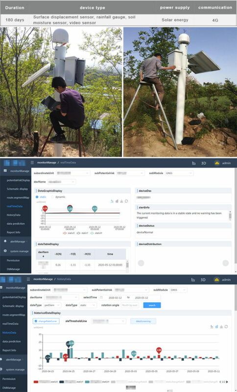
Guangzhou Zengcheng Shazhuang to Huadu Beixing Highway Phase II project is located in the northeast of Guangzhou City. The route starts from Zengcheng Licheng and connects to the first-phase project of Guangzhou Zengcheng Shazhuang to Huadu Beixing Highway, which passes through Zhongxin and Taiping. , Ending in Yanghe, Huadu, connecting Beijing-Hong Kong-Macao National Expressway. This monitoring system installs online monitoring equipment on a typical slope to monitor the safety of the slope online to achieve forewarning of abnormal conditions.
- Solutions
The equipment for this slope online monitoring project includes GNSS surface displacement monitoring, inclinometer, osmometer, and rain gauge. Provide 24-hour online monitoring and fore- warning to ensure uninterrupted monitoring of slopes in harsh environments. Analyze in time when abnormal phenomena are found, and take alarm measures to remind the parties to take necessary measures immediately to prevent accidents, give full play to engineering benefits, better serve production safety, and ensure highway safety.
- Challenges
1. The project runs through the road construction period and operation period, and the construction period is in the rainy season, which is difficult to construct; at the same time, the construction period is tight, which puts forward higher requirements on the project’s construction period and personnel management.
2 This online monitoring system not only realizes online monitoring and forewarning, but also provides a reliable reference for manual monitoring data, and realizes the complementarity between online monitoring and manual.
- Benefits
The implementation of the second phase of the Beixing Highway automated monitoring system in this city facilitates enterprises and safety supervision departments to quickly grasp the latest developments in the technical indicators closely related to the slope safety of Beixing Highway, and to incorporate the safe operation management of highways into the scope of modern scientific. Ensure the safety of people’s lives and property and social stability and tranquility, and make due contributions to building a harmonious living environment.
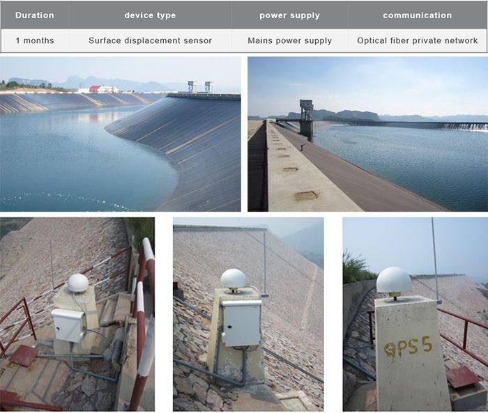
5. Dam Monitoring (Hebei, China)
- Project overview
The reservoir of Zhanghewan Pumped Storage Power Station is a first-class project. The normal storage level of the reservoir is 810m, the total storage capacity is 7.854 million cubic meters, the adjusted storage capacity is 7.2 million cubic meters, the working water depth is 31m, the dam crest elevation is 812m, and the maximum dam height is 57m. The downstream reservoir is built by using the Zhanghewan reservoir that has been built and raising the original unfinished dam. The difference between the upper and lower reservoirs is more than 300 meters.
- Solutions
Establish an online monitoring system for dams of hydropower stations to provide all-weather dam safety status, timely forecast potential threats within the monitoring range, and make an important reference for maintaining dam safety. The dam has established 7 permanent base stations, including 2 reference stations and 5 monitoring stations. One master station and one standby station to effectively ensure the normal operation of the system, establish a dam data center to automatically collect, process, and analyze displacement monitoring data, provide users with satellite observation data for each station for all days. The data access point enables remote access to the data center anywhere in the hydropower station.
- Challenges
The reservoir is located on the top of the mountain, the wireless network signal is unstable, the weather conditions on the site are complex, and rainfall and thunderstorms are frequent. The performance indicators and construction standards of the monitoring equipment are very strict. In order to ensure the power supply and communication of the system are not affected by the complex factors of the outside world, the project uses mains power supply and optical fiber dedicated network communication, which adds a larger amount of engineering than traditional solar power supply and wireless communication, and ensures that the southern monitoring system plays the largest role.
- Benefits
After the system is completed, it runs stably and efficiently, and monitors and predicts the stability, danger, disaster-causing factors, deformation and destruction methods, direction, scale, time, and disaster status of the dam. Through the monitoring equipment, we can timely grasp the safety technical indicators and operation status of the dam, provide a reliable basis for governance decisions, improve the safety of the dam, and ensure the safety of life and property of the downstream people.