


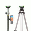
a-Geo Matrix VI Laser AR Visual RTK GNSS Receiver
This product is Available
Contact our experts for the best possible price and configuration.
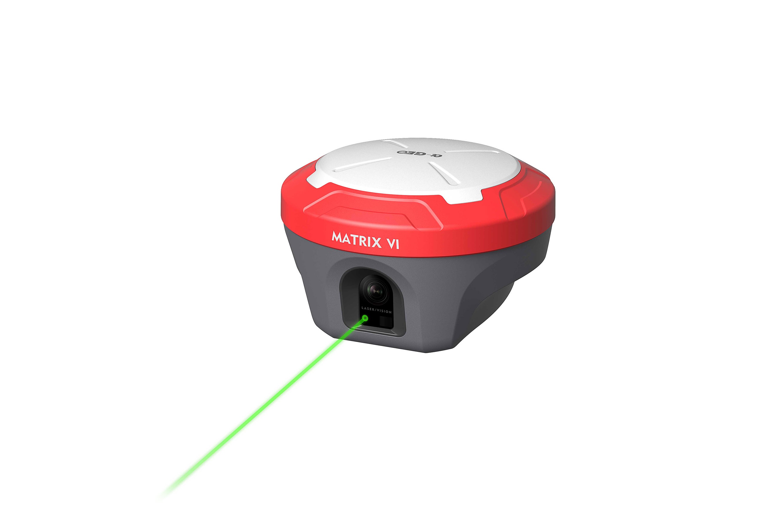
The a-Geo Matrix VI is a visual RTK GNSS receiver built for surveyors, construction teams, GIS users and mapping professionals who need accurate measurements in real field conditions. It combines multi-constellation GNSS tracking with laser measurement, AR real-scene stakeout and 120° IMU tilt compensation, helping users measure points faster without always needing to keep the pole perfectly vertical.
With its 1408-channel GNSS engine, built-in 4G, internal UHF radio and rugged IP67 housing, the Matrix VI is suitable for everyday site work, road surveys, utilities, boundary work, drone ground control and construction layout. The camera-assisted laser function is especially useful for measuring points that are difficult, unsafe or impractical to reach directly.
a-Geo Matrix VI Highlights
| GNSS Channels | 1408 channels |
|---|---|
| Satellite Tracking | GPS, GLONASS, Galileo, BeiDou, QZSS and SBAS |
| IMU Tilt Compensation | 0° to 120° with 4D IMU initialization |
| Laser Measurement | Camera-assisted laser coordinate measurement |
| AR Stakeout | Real-scene visual guidance for point stakeout |
| RTK Accuracy | Horizontal 8 mm + 1 ppm RMS, vertical 15 mm + 1 ppm RMS |
| Connectivity | 4G modem, internal UHF, WiFi and Bluetooth 5.2 |
| Rugged Design | IP67, magnesium alloy housing, less than 0.8 kg |


Valued customers:


Find RTK Networks
Search NTRIP providers and connect to reliable RTK correction services.
Description
a-Geo Matrix VI RTK GNSS receiver for faster field measurement
The a-Geo Matrix VI is a high-performance RTK GNSS receiver designed for modern surveying, construction layout, GIS data collection and mapping work. It combines traditional RTK positioning with visual measurement tools, giving field teams more ways to collect accurate points in difficult or time-sensitive situations.
For surveyors and engineers, the Matrix VI is useful when working around roads, buildings, utilities, slopes, fences, stockpiles or other locations where a standard GNSS pole setup is not always practical. Instead of relying only on direct pole placement, users can work with laser measurement, visual positioning and AR stakeout to complete more tasks with fewer repeated movements.
Visual RTK, laser measurement and AR stakeout in one receiver
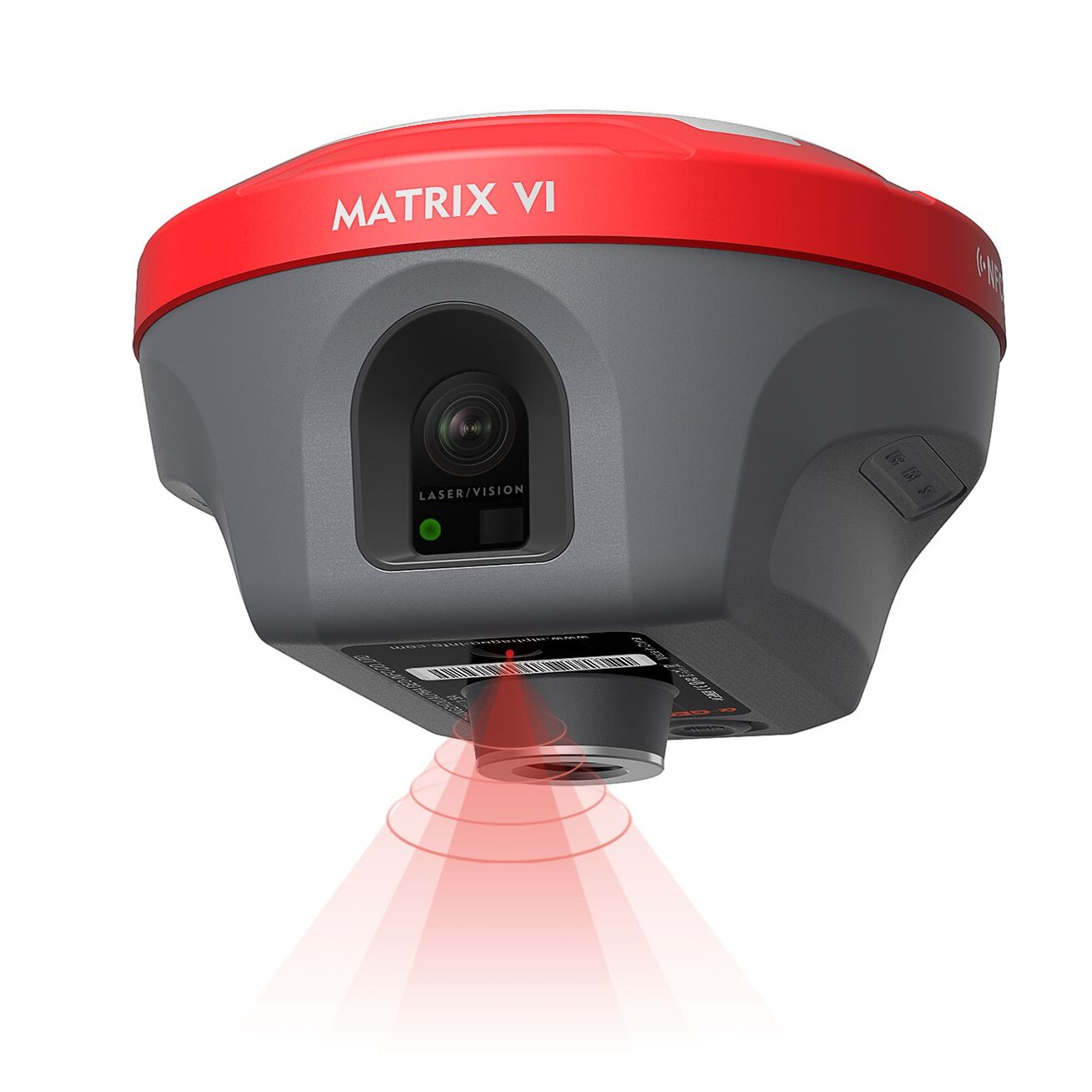
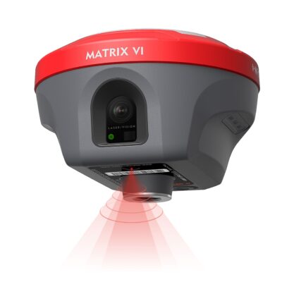
The Matrix VI brings together three practical technologies: Visual Positioning, AR real-scene stakeout and laser measurement. In daily fieldwork, this means the receiver can help measure points that are hard to occupy directly, guide users visually toward stakeout points and improve aiming during laser measurements.
The laser measurement function is especially helpful when working near traffic, obstacles, high-voltage areas, restricted surfaces or unsafe ground. Instead of standing exactly on the point, the user can aim at the target from a safer position and store the measured coordinate. The integrated camera assists with aiming, which is useful when the laser spot is difficult to see in bright outdoor conditions.
For stakeout work, AR real-scene guidance helps users find the target point using visual direction on the controller screen. This is practical for construction workers, site engineers and survey crews who need clear guidance on busy jobsites without constantly moving the pole back and forth to find the correct location.
Strong GNSS performance for demanding RTK workflows
The a-Geo Matrix VI uses a 1408-channel GNSS engine and tracks GPS, GLONASS, Galileo, BeiDou, QZSS and SBAS signals. This broad signal support helps maintain reliable positioning in common field environments such as construction sites, urban areas, open survey sites and infrastructure projects.
With RTK accuracy specified at 8 mm + 1 ppm horizontally and 15 mm + 1 ppm vertically, the Matrix VI is suitable for centimetre-level survey work when used with appropriate corrections and good field conditions. It supports network RTK workflows, base and rover operation, internal UHF radio, 4G connectivity and standard correction formats such as RTCM, CMR and CMR+.
120° IMU tilt compensation for practical measuring
The built-in IMU allows measurements with the pole tilted up to 120°. This is useful when collecting points near walls, under obstacles, beside trenches, along building edges or in places where keeping the pole perfectly vertical slows the job down. The IMU initializes quickly and is designed to reduce repeated calibration steps, helping crews continue working with fewer interruptions.
For construction professionals and GIS teams, tilt compensation can make a real difference in day-to-day productivity. Points can be captured more comfortably, especially in uneven terrain, tight spaces or locations where the pole tip is visible but the receiver cannot be positioned directly above it.
Built for survey, construction, GIS and drone support workflows
The Matrix VI fits a wide range of professional GNSS tasks. Surveyors can use it for topographic surveys, boundary work, control points and as-built checks. Construction teams can use it for layout, earthworks checks, road projects and site verification. GIS users can collect accurate asset positions for utilities, infrastructure, environmental mapping and municipal databases.
Drone pilots and mapping teams can also use the Matrix VI for ground control points and reference workflows. The receiver supports NTRIP and can be configured through its internal Web UI, making it flexible for teams that work with correction services, local base stations or project-specific RTK setups.
Reliable connectivity in the field
The a-Geo Matrix VI includes a full-frequency multi-band 4G modem, internal UHF radio, WiFi and Bluetooth 5.2. This gives users several ways to receive or transmit corrections depending on the jobsite. A rover can work through a CORS network using a SIM card, while base and rover setups can use the internal UHF radio where network coverage is not available or preferred.
The receiver also supports Web UI configuration, allowing users to monitor and configure the device through a browser connection. This is useful for setup, troubleshooting, file management and firmware-related tasks without needing a complicated workflow.
Rugged receiver for everyday site conditions
The Matrix VI is built with a magnesium alloy housing and weighs less than 0.8 kg, making it practical for long field days. Its IP67 rating protects it against dust and water exposure, and the receiver is rated to survive a 2 m pole drop onto concrete. The operating temperature range from -40°C to +75°C makes it suitable for demanding outdoor environments.
A built-in 7000 mAh battery provides up to 12 hours in rover mode, 7 hours in base mode and 15 hours in static mode. USB Type-C charging and data transfer make day-to-day handling easier for field crews who need a receiver that is both capable and practical.
Why buy the a-Geo Matrix VI from Global GPS Systems?
Global GPS Systems supplies RTK GNSS equipment to surveyors, construction professionals, drone pilots, GIS teams and mapping companies worldwide. When choosing an advanced receiver like the a-Geo Matrix VI, support and configuration advice matter just as much as the hardware itself.
Global GPS Systems can help buyers choose the right setup for their workflow, whether that is a single rover, rover and base configuration, RTK correction service, controller setup or accessories for daily field use. This helps teams get a practical GNSS solution that fits the way they actually work on site.
Datasheets & Manuals
Datasheets and manuals
a-Geo Datasheets
Specifications
a-Geo Matrix VI Specifications
Product Overview
| Product Name | a-Geo Matrix VI |
|---|---|
| Product Type | RTK GNSS receiver with AR, visual positioning and laser measurement |
| Brand / Manufacturer | a-Geo / Guangzhou Alpha Geo-Info Co., Ltd. |
| Main Applications | RTK surveying, stakeout, static GNSS surveying, network RTK, laser-assisted measurement, photogrammetry-supported measurement and field data collection |
| Key Technologies | AR real-scene stakeout, visual positioning, laser surveying, 4D IMU tilt compensation, multi-constellation GNSS tracking, built-in UHF and 4G connectivity |
| GNSS Channels | 1408 channels |
| Operating System | Linux OS |
GNSS Performance
| GPS Signals | L1 C/A, L2C, L2P, L5 |
|---|---|
| GLONASS Signals | L1, L2 |
| BeiDou / BDS Signals | B1, B1C, B2, B2a, B2b, B3 |
| Galileo Signals | E1, E5a, E5b, E6 |
| QZSS Signals | L1, L2, L5, L6 |
| SBAS Support | WAAS, EGNOS, MSAS, GAGAN, SDCM |
| Channels | 1408 |
| Cold Start | <60 seconds |
| Hot Start | <15 seconds |
| Positioning Output Rate | 1 Hz to 50 Hz |
| Signal Reacquisition | <1 second |
| RTK Initialization Time | <5 seconds |
| Initialization Reliability | >99.99% |
| Time Accuracy | 20 ns |
Positioning Accuracy
| Code Differential GNSS Positioning | Horizontal: 0.25 m + 1 ppm RMS; Vertical: 0.50 m + 1 ppm RMS |
|---|---|
| SBAS Differential Positioning Accuracy | Typically <5 m 3DRMS |
| Static GNSS Surveying | Horizontal: 2.5 mm + 0.5 ppm RMS; Vertical: 5 mm + 0.5 ppm RMS |
| RTK Surveying, Baseline <30 km | Horizontal: 8 mm + 1 ppm RMS; Vertical: 15 mm + 1 ppm RMS |
| Network RTK | Horizontal: 8 mm + 0.5 ppm RMS; Vertical: 15 mm + 0.5 ppm RMS |
| Laser Measurement Accuracy | 1 cm + 5 mm/m |
| Photogrammetry Accuracy | 2–4 cm, 95% confidence / 2σ, at 10 m under normal lighting conditions |
Laser, AR and Visual Measurement
| Laser Surveying | Supported |
|---|---|
| Laser Measurement Use | Allows measurement from a safe distance for hard-to-reach, dangerous or obstructed points |
| AR Real-Scene Stakeout | Supported |
| Visual Positioning | Supported |
| Camera-Assisted Measurement | Supported for aiming and visual measurement workflows |
| Stakeout Guidance | AR guidance with real-scene point indication and intuitive direction guidance |
Sensor and IMU
| IMU | Supported |
|---|---|
| IMU Type / Function | 4D IMU with tilt compensation |
| IMU Initialization | Initialization in 3 seconds |
| IMU Update Rate | 400 Hz |
| IMU Accuracy | <2.5 cm within 120° |
| Tilt Compensation Range | 0° to 120° |
Camera
| Visual Camera | Global shutter, 2 MP |
|---|---|
| AR Camera | 5 MP |
| Field of View | 84° |
Communications
| I/O Interface | 1 × 5-pin LEMO port for power supply, RS232 and external radio communication |
|---|---|
| USB Interface | 1 × USB Type-C port for charging and data download |
| SIM Card Slot | 1 × Nano SIM card slot |
| UHF Antenna Interface | 1 × UHF antenna interface |
| Internal UHF | 1.5 W receiver and transmitter |
| UHF Frequency Band | 410 MHz to 470 MHz, supports frequency modification |
| UHF Protocols | Trimtalk450S, Alphatalk15, South, Satel, PCC-EOT |
| Cellular Network | Full-frequency multi-band 4G modem |
| Cellular Standards | TDD-LTE, FDD-LTE, WCDMA, CDMA2000 |
| Wi-Fi | 802.11 b/g, access point and client mode |
| Wi-Fi Correction Support | Supports accessing a hotspot for correction transmission |
| Bluetooth | Bluetooth 5.2 classical / BLE proprietary dual-mode |
| Differential Data Format | RTCM2x, RTCM3x, CMR, CMR+, sCMRx |
| GPS Output Data Format | RINEX, NMEA-0183 |
Electrical and Battery
| External Power Input | 9–24 V DC external power input to 5-pin LEMO port |
|---|---|
| Charging | Supports USB Type-C fast charging |
| Battery Type | Built-in Li-ion battery |
| Battery Capacity | 7000 mAh, 7.4 V |
| Battery Life – Rover Mode | 12 hours |
| Battery Life – Base Mode | 7 hours |
| Battery Life – Static Mode | 15 hours |
Data Storage
| Internal Memory | 64 GB |
|---|---|
| Cyclic Storage | Supported |
| Raw Observation Storage | Can collect almost 4 years of raw observation data based on a 5-second interval |
Physical Specifications
| Housing Material | Magnesium alloy |
|---|---|
| Dimensions | 129 mm × 129 mm × 99 mm |
| Weight | <0.8 kg |
| Operating Temperature | -40°C to +75°C |
| Storage Temperature | -55°C to +85°C |
| Waterproof / Dustproof Rating | IP67 standard, protected from 30-minute immersion to a depth of 1 m |
| Shock Resistance | Survives a 2 m pole drop onto concrete |
| Vibration | MIL-STD-810G |
| Humidity | 100% non-condensing |
User Interaction
| Operating System | Linux OS |
|---|---|
| Buttons | Power key |
| Indicators | 1 × power indicator, 1 × Bluetooth indicator, 1 × satellite indicator, 1 × data link indicator |
| Voice Prompts | Intelligent voice prompts |
| Web UI | Supports Web UI configuration |
Measurement Notes
| GNSS Accuracy Conditions | Precision and reliability may be affected by multipath, obstructions, satellite geometry and atmospheric conditions. |
|---|---|
| Recommended GNSS Conditions | Stable open-sky environment, low EMI, clean multipath conditions and optimal GNSS constellation configuration are recommended. |
| Long Baseline Static Surveying | Baselines longer than 30 km may require ephemeris and occupations up to 24 hours to achieve high-precision static specifications. |
| SBAS Accuracy Note | Depends on SBAS system performance. |
| Network RTK Accuracy Note | Network RTK ppm values are referenced to the closest physical base station and depend on network performance. |
Specifications and package contents may vary by configuration, region or manufacturer update. Always check the current configuration before ordering.
FAQ
a-Geo Matrix VI FAQ
Product Overview
What is the a-Geo Matrix VI?
The a-Geo Matrix VI is a professional survey-grade GNSS RTK receiver designed for high-accuracy field measurement, mapping, construction layout, stakeout, and geospatial surveying. It combines GNSS positioning with Visual Positioning, AR real-scene stakeout, laser measurement, IMU tilt compensation, 4G, UHF radio, Wi-Fi, and Bluetooth.
Who is the a-Geo Matrix VI designed for?
The Matrix VI is designed for land surveyors, construction survey crews, civil engineers, mapping professionals, GIS teams, infrastructure contractors, and other users who need accurate and efficient RTK positioning in the field.
What makes the Matrix VI different from a standard RTK receiver?
Unlike a standard RTK receiver, the Matrix VI combines conventional GNSS RTK with visual measurement, AR-guided stakeout, laser measurement, and high-angle IMU tilt compensation. This helps users measure points that are difficult, unsafe, or inefficient to reach with a traditional GNSS pole setup.
Can the Matrix VI be used for professional land surveying?
Yes. The a-Geo Matrix VI is built for professional surveying applications and supports multi-constellation, multi-frequency GNSS positioning, RTK workflows, static observations, visual measurement, laser measurement, and field stakeout.
Which industries commonly use the a-Geo Matrix VI?
The Matrix VI is suitable for land surveying, construction, civil engineering, road and infrastructure projects, utilities, mapping, GIS data collection, topographic surveys, and other geospatial field applications.
Accuracy, GNSS and RTK Performance
How accurate is the a-Geo Matrix VI in RTK mode?
The Matrix VI offers RTK accuracy of approximately 8 mm + 0.5 ppm horizontally and 15 mm + 0.5 ppm vertically, depending on field conditions, satellite geometry, correction source, and workflow setup.
How many GNSS channels does the Matrix VI have?
The a-Geo Matrix VI has 1408 GNSS channels, allowing it to track multiple satellite constellations and frequencies for fast and reliable positioning.
Which satellite constellations does the Matrix VI support?
The Matrix VI supports major GNSS constellations including GPS, GLONASS, Galileo, BeiDou, QZSS, and SBAS signals, depending on configuration and regional availability.
Does the Matrix VI support RTK network corrections?
Yes. The Matrix VI can connect to RTK correction services through NTRIP using its built-in 4G modem or network connection. It can also work with local base station corrections through UHF radio.
Can the Matrix VI be used as both a base and a rover?
Yes. The Matrix VI can be configured as a rover or as a base station. It supports correction transmission through internal UHF, network connection, and NTRIP workflows.
What UHF radio frequency range does the Matrix VI use?
The Matrix VI includes UHF radio support in the 410–470 MHz range. This allows local base-rover correction workflows where UHF radio communication is suitable and permitted.
Visual Positioning, AR Stakeout and Laser Measurement
What is Visual Positioning on the a-Geo Matrix VI?
Visual Positioning allows users to capture site images or video and measure point coordinates from visual data. This is useful for points that are hard to access directly with a GNSS pole.
What is AR real-scene stakeout?
AR real-scene stakeout uses the receiver camera view to guide users toward stakeout points in the real environment. This can make stakeout faster and more intuitive because the operator can follow visual guidance on the controller screen.
Does the Matrix VI have a laser measurement function?
Yes. The Matrix VI includes a green laser measurement function that helps measure points without placing the receiver directly on the target point. This is useful for inaccessible, obstructed, or unsafe locations.
How accurate is the laser measurement?
The Matrix VI laser measurement accuracy is listed as approximately 1 cm + 5 mm/m. Actual results can depend on setup, target visibility, distance, calibration, and site conditions.
What are the cameras on the Matrix VI used for?
The Matrix VI uses camera technology for AR stakeout, laser aiming assistance, and visual surveying. One camera supports AR stakeout, while the other supports laser assist and Visual 3D measurement workflows.
Can the Matrix VI measure points that are difficult to reach?
Yes. The combination of laser measurement, visual positioning, and IMU tilt compensation helps users measure points near walls, obstacles, traffic areas, fences, slopes, trenches, or other locations where placing a pole directly on the point is difficult.
Field Use, Connectivity and Durability
What is the maximum tilt angle of the Matrix VI IMU?
The Matrix VI supports IMU tilt compensation up to 120 degrees. This allows users to measure while the pole is tilted, helping improve speed and flexibility in difficult field conditions.
Does the IMU need calibration?
The Matrix VI is designed with advanced IMU technology to reduce complicated calibration steps. In normal workflows, the IMU can be initialized quickly in the field before tilt-compensated measurement.
Is the a-Geo Matrix VI waterproof and dustproof?
Yes. The Matrix VI has an IP67 protection rating, meaning it is protected against dust and temporary immersion in water up to 1 metre for up to 30 minutes.
How durable is the Matrix VI for field work?
The receiver has a magnesium alloy housing, IP67 protection, vibration resistance, and drop resistance up to 2 metres onto concrete, making it suitable for demanding outdoor survey environments.
What is the battery life of the Matrix VI?
The Matrix VI battery life is listed as up to 12 hours in rover mode, 7 hours in base mode, and 15 hours in static mode, depending on settings, communication method, temperature, and field use.
What connectivity options does the Matrix VI support?
The Matrix VI supports UHF radio, built-in 4G, Wi-Fi, Bluetooth, USB Type-C, and Nano-SIM connectivity. These options allow flexible RTK correction, data transfer, receiver configuration, and controller connection workflows.
Can the Matrix VI be configured through a Web UI?
Yes. The Matrix VI includes a Web UI for receiver configuration, monitoring, work mode setup, data communication settings, static data download, firmware updates, and system management.
What data formats does the Matrix VI support?
The Matrix VI supports common GNSS data and correction formats including RTCM, CMR, CMR+, RINEX, and NMEA-0183, making it suitable for many professional surveying and positioning workflows.
Reviews (0)
Only logged in customers who have purchased this product may leave a review.
Reviews
There are no reviews yet