

South Galaxy G4 RTK GNSS Receiver with IMU Tilt
This product is Available
Contact our experts for the best possible price and configuration.
The South Galaxy G4 is a professional RTK GNSS receiver built for surveyors, construction teams, GIS field crews and mapping professionals who need reliable centimetre-level positioning in real field conditions. With a 1698-channel S805 GNSS engine, 60° IMU tilt compensation, 4G connectivity and internal UHF radio, the G4 is suitable for rover work, base-rover setups, stakeout, topographic surveys, construction layout and data collection in open or challenging environments.
South Galaxy G4 Highlights
| GNSS Channels | 1698 channels with S805 GNSS engine |
|---|---|
| IMU Tilt Compensation | Up to 60° tilt angle for faster point measurement |
| Satellite Support | GPS, GLONASS, Galileo, BeiDou, SBAS, QZSS, NavIC and IRNSS |
| Communication | 4G, Bluetooth, WiFi, NFC, Type-C, RS232 and internal UHF |
| Internal UHF Radio | 2W radio, 410–470 MHz, Farlink, Trimtalk and SOUTH protocols |
Valued customers:


Find RTK Networks
Search NTRIP providers and connect to reliable RTK correction services.
Description
South Galaxy G4 RTK GNSS Receiver
The South Galaxy G4 is a modern RTK GNSS receiver designed for professional surveying, construction layout, GIS mapping and field data collection. It is built for users who need fast fixed solutions, flexible communication options and practical performance on real job sites. Whether you are measuring site control, staking out points, mapping assets or collecting topographic data, the Galaxy G4 gives field crews a strong balance of accuracy, durability and usability.
At the heart of the receiver is the S805 GNSS engine with 1698 channels. In everyday fieldwork, this means the receiver can track a wide range of satellite signals and use more available data to help maintain a stable RTK solution. This is useful for surveyors and engineers working near buildings, tree cover, embankments or other environments where satellite visibility is not always ideal.
Built for surveyors, construction crews and GIS field teams
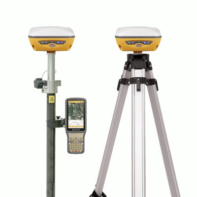
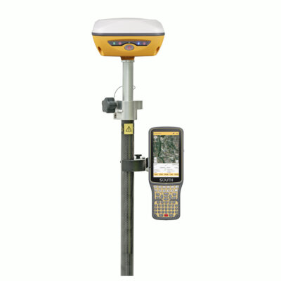
The South Galaxy G4 is suitable for land surveyors, civil engineers, construction professionals, drone mapping teams, utility mappers, forestry users and GIS workers who require accurate positioning in the field. For construction teams, it can be used for layout, as-built checks, levels, control points and machine control support workflows. For surveyors and GIS crews, it supports boundary work, topographic surveys, asset collection, road surveys, site measurements and mapping projects.
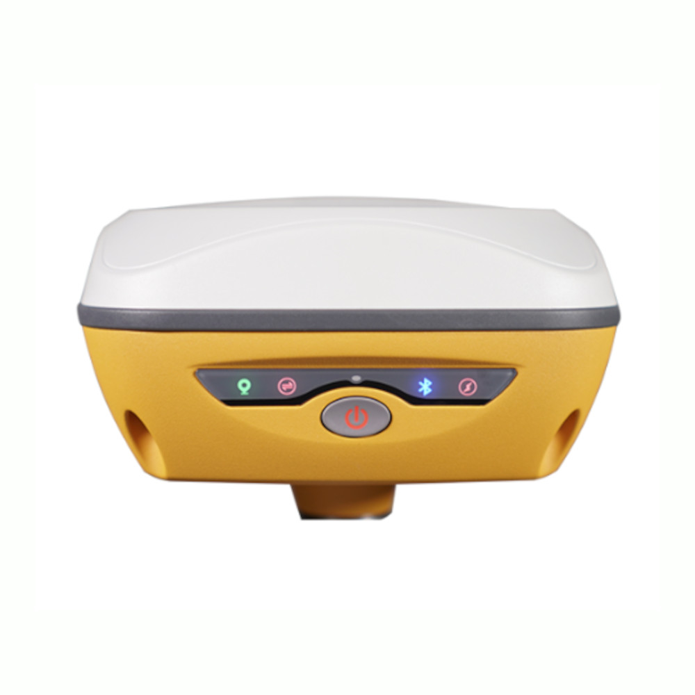
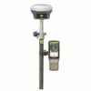
The receiver’s yellow bodywork is designed to make the unit easier to see on construction sites, in vegetation and in low-light working conditions. This may sound simple, but it is a practical detail for busy job sites where equipment visibility helps protect both people and instruments.
IMU tilt compensation for faster measurements
The integrated IMU tilt system helps reduce the need to keep the pole perfectly level for every point. In practical terms, this makes it easier to measure points near walls, fences, corners, trenches, slopes, traffic areas or other places where holding the pole upright is difficult. The G4 supports tilt angles up to 60°, helping field crews work faster while still maintaining reliable measurement workflows.
The updated IMU system is designed to remain usable in more common field situations, including when the pole is rotated during movement or while changing direction. This makes the G4 easier to use for long survey sessions and for crews who need to move quickly between points.
Flexible RTK communication for different job sites
The South Galaxy G4 includes several communication options, making it adaptable to different working methods. The built-in 4G modem is useful for connecting to RTK correction networks through NTRIP, while the internal UHF radio supports base-rover work in areas without dependable mobile internet. WiFi, Bluetooth, NFC, Type-C and RS232 provide additional options for configuration, data transfer and connection to field controllers or other equipment.
The internal UHF radio supports the 410–470 MHz range and communication protocols such as Farlink, Trimtalk and SOUTH. For surveyors working with a local base station, this helps create a practical rover and base workflow without depending entirely on network coverage.
Rugged design for daily outdoor use
The G4 housing uses AZ91D magnesium alloy, selected for strength and heat dissipation. The receiver is designed for outdoor surveying conditions, with a compact body, field-focused controls and a durable construction suitable for daily use. The receiver also includes a built-in battery system and can be charged with Type-C, which is useful for field teams that already carry modern charging equipment.
Its Web UI can be accessed through WiFi or cable, allowing users to check receiver status, configure communication settings, manage radio parameters, review satellite tracking and perform firmware-related tasks. This is helpful for survey managers and experienced users who want more control over the receiver without relying only on a controller interface.
Data collection and office workflow support
The Galaxy G4 supports static and RTK workflows, raw data recording, data download and common GNSS data formats. This makes it suitable not only for live RTK work but also for static surveys, post-processing workflows and projects where GNSS data needs to be checked or processed after field collection.
For crews using SOUTH field and office software, the receiver can be part of a complete workflow from field measurement to data processing. Surveyors can collect points, manage layers, perform stakeout, record static data and prepare data for office use. This is valuable for teams that need a receiver that can handle both everyday construction measurements and more traditional surveying tasks.
Who should choose the South Galaxy G4?
The South Galaxy G4 is a strong choice for buyers who want a capable RTK GNSS receiver with IMU tilt, 4G, UHF and broad satellite tracking without moving into the highest-end visual or laser GNSS category. It is especially suitable for surveyors, contractors and GIS users who need reliable RTK positioning, flexible correction options and a receiver that can handle changing site conditions.
Global GPS Systems can help match the South Galaxy G4 with the right field controller, software, pole, tripod, base-rover setup or RTK network workflow. This makes it easier to build a complete GNSS solution that fits the way your team actually works in the field.
Datasheets & Manuals
Datasheets and manuals
Datasheet
Specifications
South Galaxy G4 Specifications
Product Overview
| Product Name | South Galaxy G4 |
|---|---|
| Product Type | RTK GNSS receiver / GNSS positioning system |
| Primary Use | Land surveying, construction positioning, control survey, CORS/RTK work, static GNSS measurement, stakeout and mapping |
| GNSS Engine | SOUTH S805 GNSS engine |
| Channels | 1698 channels |
| IMU Tilt Sensor | Built-in 4th generation IMU tilt compensation |
| Tilt Measurement Range | 0° to 60° |
| Operating System | Linux |
GNSS Tracking
| GPS | L1, L1C, L2C, L2P, L5 |
|---|---|
| GLONASS | G1, G2, G3 |
| BeiDou / BDS | B1I, B2I, B3I, B1C, B2a, B2b |
| Galileo | E1, E5A, E5B, E6C |
| SBAS | L1C, L1A |
| IRNSS | L5 |
| QZSS | L1, L2C, L5 |
| MSS L-Band | Reserved / configuration dependent |
| Positioning Output Rate | 1 Hz to 20 Hz |
| Initialization Time | < 10 seconds |
| Initialization Reliability | > 99.99% |
Positioning Precision
| Positioning Mode | Horizontal Accuracy | Vertical Accuracy |
|---|---|---|
| Code Differential GNSS Positioning | 0.25 m + 1 ppm RMS | 0.50 m + 1 ppm RMS |
| GNSS Static | 2.5 mm + 0.5 ppm RMS | 5 mm + 0.5 ppm RMS |
| Real-Time Kinematic RTK, baseline < 30 km | 8 mm + 1 ppm RMS | 15 mm + 1 ppm RMS |
| SBAS Positioning | Typically < 5 m 3DRMS | |
RTK and IMU Performance
| RTK Initialization Time | 2 to 8 seconds |
|---|---|
| IMU Tilt Compensation | Additional horizontal pole tip uncertainty typically less than 10 mm + 0.7 mm/° tilt down to 30° |
| IMU Tilt Angle | 0° to 60° |
| IMU Calibration | Calibration-free IMU module |
| Magnetic Interference Resistance | IMU is immune to magnetic interference |
| Fixed-Keep Function | Allows continued measurement for a period after losing fixed solution, depending on field conditions |
| PPP Support | Supports Beidou PPP and Galileo HAS functions where service/configuration is available |
Physical Specifications
| Dimensions | 135 mm (L) × 135 mm (W) × 84.75 mm (H) |
|---|---|
| Weight | 890 g, battery included |
| Housing Material | Magnesium aluminium alloy shell |
| Body Material Detail | AZ91D magnesium alloy body with metallic paint finish |
| Top Cover Material | One-piece molded polycarbonate top cover |
| Receiver Color | High-visibility yellow bodywork |
| Buttons | Single button |
| Indicators | 4 LED indicators |
Environmental and Durability
| Operating Temperature | -25°C to +65°C |
|---|---|
| Storage Temperature | -35°C to +80°C |
| Humidity | 100% non-condensing |
| Waterproof Rating | IP68, protected from long-time immersion to a depth of 1 m |
| Dustproof Rating | IP68, fully protected against blowing dust |
| Shock / Vibration | MIL-STD-810G; withstands a natural 2 m pole drop onto cement ground |
| Radio Temperature Testing | Farlink 2.0 radio tested through -20°C to +60°C temperature-changing conditions |
| Anti-Compression Ability | 121.5 kNm/kg specific strength reference value |
| Anti-Impact Ability | 43.4 J reference value |
Power and Battery
| External Power Input | 6 V to 28 V DC, with overvoltage protection |
|---|---|
| Battery Type | Built-in rechargeable lithium-ion battery |
| Battery Specification | 7.4 V, 6800 mAh |
| Charging Interface | USB Type-C with PD adapter |
| Typical Battery Life – Static | 20 hours |
| Typical Battery Life – Internal UHF Base Mode | 7 hours |
| Typical Battery Life – Rover + UHF | 19 hours |
| Typical Battery Life – Rover + Bluetooth | 20 hours |
Communication Interfaces
| 5-PIN LEMO Interface | External power port + RS232 |
|---|---|
| USB Interface | Type-C USB interface |
| USB Functions | USB, OTG and Ethernet |
| UHF Antenna Interface | 1 UHF antenna interface |
| Bluetooth | Bluetooth 3.0 / 4.1 standard, Bluetooth 2.1 + EDR compatible |
| NFC Communication | Close-range automatic pairing between receiver and controller at shorter than 10 cm, when controller supports NFC |
| Cellular Modem | 4G |
| WiFi Standard | 802.11 b/g/n |
| WiFi Hotspot | Receiver can broadcast a hotspot for Web UI access by mobile terminals |
| WiFi Datalink | Receiver can transmit and receive correction data stream via WiFi datalink |
| Downlink Data Rate | 150 Mbps reference value |
Internal UHF Radio
| Internal UHF | 2 W radio receiver and transmitter |
|---|---|
| Frequency Range | 410 MHz to 470 MHz |
| Radio Protocols | Farlink, Farlink 2.0, Trimtalk, SOUTH, HUACE, Hi-target, Satel |
| Communication Range | Typically 5 km with Farlink protocol; up to 12 km depending on field conditions |
| Base Lock Function | Farlink protocol can lock to a specific base station to reduce interference from other bases on the same frequency |
| Radio Power Setting | High, middle or low power settings in base mode |
| Radio Channels | 16 configurable radio channels through Web UI radio frequency settings |
Data Storage and Transmission
| Internal Storage | 4 GB SSD internal storage standard |
|---|---|
| Expandable Storage | Expandable up to 128 GB with external USB storage |
| Automatic Cycle Storage | Oldest data files are removed automatically when memory is insufficient |
| External USB Storage | Supported |
| Sample Interval | Customizable sample interval up to 20 Hz |
| USB Data Transmission | Plug-and-play USB data transmission |
| Remote Data Download | Supports FTP / HTTP data download |
| Track Recording | Supports track recording during measurement and data download through receiver interface |
| System Logs | System log download supported through Web UI |
Supported Data Formats
| Static Data Formats | STH, RINEX 2.01, RINEX 3.02 and related static formats |
|---|---|
| Differential Data Formats | CMR, RTCM 2.1, RTCM 2.3, RTCM 3.0, RTCM 3.1, RTCM 3.2 |
| GPS Output Data Formats | NMEA 0183, PJK plane coordinate, SOUTH binary code |
| Network Model Support | VRS, FKP, MAC |
| NTRIP Support | Fully supports NTRIP protocol |
| OpenSIC | OpenSIC observation data format and interaction interface definition available for secondary development |
Sensors
| Electronic Bubble | Controller software can display electronic bubble and check carbon pole leveling status in real time |
|---|---|
| IMU | Built-in calibration-free IMU module, immune to magnetic interference |
| Thermometer | Built-in thermometer sensor |
| Temperature Control | Intelligent temperature control technology monitors and adjusts receiver temperature |
User Interaction and Management
| Web UI | Internal Web UI management via WiFi or USB connection |
|---|---|
| Receiver Monitoring | Web UI allows users to monitor receiver status and change configurations |
| Firmware Update | Firmware update through Web UI, including online and local update methods |
| Module Update | Supports firmware update for related modules such as OEM board, radio module and sensor |
| Voice Guidance | Status and operation voice guidance |
| Supported Voice Languages | Chinese, English, Korean, Spanish, Portuguese, Russian, Turkish |
| Cloud Service | Supports online services such as remote management, firmware update and online registration |
| Secondary Development | Provides secondary development package and OpenSIC observation data/interface access |
Software and Field Workflow
| Compatible Field Software | SurvStar app and SOUTH field data collection workflows |
|---|---|
| Data Collection | Field data collection, mapping, static measurement and PPK measurement workflows supported through compatible software |
| Stakeout | Point, line, CAD and area division stakeout workflows supported through compatible software |
| CAD Workflow | Supports CAD drawing and CAD stakeout workflows through compatible field software |
| Office Processing | Compatible with SOUTH Geo Office workflows for GNSS data processing and reporting |
| RINEX Workflow | RINEX import/export and STH to RINEX conversion supported through compatible software workflows |
Applications and Industry Use
| Land Surveying | Boundary, cadastral, topographic and control survey workflows |
|---|---|
| Construction | Site positioning, stakeout, machine-control support workflows and construction layout tasks |
| Control Survey | Dual-frequency static measurements for high-precision control and deformation observation workflows |
| Highway Survey | Control point densification, road topographic mapping, cross-section and profile measurement workflows |
| CORS / Network RTK | Network rover operation through cellular, WiFi and NTRIP-compatible correction services |
| Challenging Environments | Designed for field work in construction sites, forests, urban canyons and other environments where signal quality or visibility may be difficult |
Included Items and Accessories
| Item | Quantity | Notes |
|---|---|---|
| South Galaxy G4 Receiver | 1 | Main GNSS receiver unit; exact configuration may vary |
| Rechargeable Internal Battery | Built-in | 7.4 V, 6800 mAh lithium-ion battery |
| Instrument Case | 1 | Hard carrying case with inner anti-collision foam, configuration dependent |
| USB Type-C Cable | 1 | Used for static data transmission, Web UI access and firmware update |
| PD Adapter / Charger | 1 | Used for charging the internal battery via Type-C connection |
| UHF Differential Antenna | Configuration dependent | Required when using the receiver in internal UHF mode |
| Controller / Data Collector | Configuration dependent | May be included in rover or base-rover kits depending on purchased package |
| Survey Pole / Mounting Accessories | Configuration dependent | Availability depends on kit configuration and regional package |
Specifications and package contents may vary by configuration, region or manufacturer update. Always check the current configuration before ordering.
FAQ
South Galaxy G4 FAQ
Product Use & Applications
What is the South Galaxy G4 used for?
The South Galaxy G4 is a professional RTK GNSS receiver used for high-precision positioning tasks such as land surveying, construction layout, mapping, control surveys, road surveys, stakeout, utility measurement and other field data collection work.
Who is the South Galaxy G4 designed for?
The South Galaxy G4 is designed for surveyors, construction professionals, civil engineering teams, GIS and mapping users, infrastructure contractors, road survey teams and other professionals who need accurate GNSS positioning in the field.
Can the South Galaxy G4 be used for land surveying?
Yes. The South Galaxy G4 is suitable for land surveying tasks such as topographic surveys, control point measurement, static observations, RTK surveys, data acquisition and stakeout work.
Is the South Galaxy G4 suitable for construction layout?
Yes. The receiver is suitable for construction layout and site positioning because it supports RTK positioning, IMU tilt compensation, UHF radio, 4G connectivity and stable data communication for field workflows.
Can the South Galaxy G4 be used for road and highway surveys?
Yes. The South Galaxy G4 can be used for road and highway survey tasks including control point densification, topographic mapping, cross-section measurement, profile measurement and stakeout.
Can the South Galaxy G4 be used for stakeout?
Yes. The South Galaxy G4 can be used for point, line and surface stakeout, making it useful for surveying, construction, infrastructure and engineering projects.
GNSS Performance & Accuracy
How many channels does the South Galaxy G4 have?
The South Galaxy G4 has 1698 channels, allowing it to track multiple GNSS signals for reliable positioning performance in demanding field environments.
Which satellite constellations does the South Galaxy G4 support?
The South Galaxy G4 supports major GNSS constellations including GPS, GLONASS, Galileo and BeiDou. It also supports additional satellite signals depending on configuration and firmware availability.
Does the South Galaxy G4 support RTK positioning?
Yes. The South Galaxy G4 is an RTK GNSS receiver designed for real-time high-precision positioning when used with suitable correction data from a base station, UHF radio link or RTK network.
What RTK accuracy can the South Galaxy G4 achieve?
Under suitable field conditions, the South Galaxy G4 can achieve RTK-level precision. Actual accuracy depends on satellite geometry, correction source, observation conditions, baseline length, multipath, obstructions and local environment.
How fast does the South Galaxy G4 initialize RTK?
The South Galaxy G4 has a typical RTK initialization time of 2 to 8 seconds under suitable conditions. Initialization speed can vary depending on satellites, corrections, environment and signal quality.
Does the South Galaxy G4 work in difficult environments?
Yes. The receiver is built for professional field use and supports multi-constellation tracking, weak-signal tracking, IMU tilt measurement and stable data links to help maintain productivity in challenging areas such as construction sites, urban areas and wooded environments.
IMU Tilt, Connectivity & Field Workflow
What is IMU tilt compensation on the South Galaxy G4?
IMU tilt compensation allows the receiver to measure points even when the survey pole is not perfectly level. This helps users measure faster around obstacles, walls, corners, slopes and other difficult-to-reach points.
How much tilt does the South Galaxy G4 support?
The South Galaxy G4 supports IMU tilt measurement up to 60 degrees, helping users collect accurate points without always holding the pole completely vertical.
Does the South Galaxy G4 IMU require calibration?
The South Galaxy G4 uses a calibration-free IMU module, reducing setup time and making field measurement easier for surveyors and construction users.
Does the South Galaxy G4 have a 4G modem?
Yes. The South Galaxy G4 includes 4G connectivity, allowing it to work with mobile data connections for RTK network and NTRIP workflows where supported by the local network and SIM provider.
Does the South Galaxy G4 support UHF radio?
Yes. The South Galaxy G4 has an internal UHF radio with a 410–470 MHz frequency range. This allows base-rover communication when working without an internet-based correction source.
What is Farlink 2.0?
Farlink 2.0 is South’s upgraded radio communication protocol designed to provide stable data transmission between GNSS receivers in base-rover field workflows.
Can the South Galaxy G4 connect to RTK networks?
Yes. The receiver supports NTRIP-based workflows, allowing users to connect to compatible RTK correction networks through mobile internet or other supported data links.
Hardware, Data & Durability
Is the South Galaxy G4 waterproof and dustproof?
Yes. The South Galaxy G4 is rated IP68, meaning it is protected against dust and water exposure for demanding outdoor field conditions.
How durable is the South Galaxy G4?
The South Galaxy G4 uses a magnesium-aluminium alloy housing and is designed for field durability. It is rated to withstand a 2 metre pole drop onto cement under the stated test conditions.
How long does the South Galaxy G4 battery last?
The South Galaxy G4 uses an internal 7.4V 6800mAh rechargeable lithium-ion battery. Battery life depends on the working mode, but typical figures include up to 20 hours in static mode and up to 20 hours in rover mode with Bluetooth.
How much storage does the South Galaxy G4 have?
The South Galaxy G4 includes 4GB internal SSD storage and supports external USB storage expansion up to 128GB for raw data and static observation files.
Which data formats does the South Galaxy G4 support?
The South Galaxy G4 supports static data formats including STH, RINEX 2.01 and RINEX 3.02. It also supports common differential and GNSS output formats for professional survey workflows.
How can I configure the South Galaxy G4?
The South Galaxy G4 can be configured through its internal Web UI using WiFi or USB. Users can monitor receiver status, adjust settings, manage data, configure communication options and update device parameters.
Reviews (0)
Only logged in customers who have purchased this product may leave a review.
Reviews
There are no reviews yet