South ALPS2 Rover Base set Product Review
The South ALPS2 Receiver
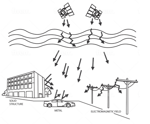
The South ALPS2 is a cutting-edge GNSS receiver for land surveying, equipped with laser measurement, IMU tilt compensation, and camera vision technology. Capture hard-to-reach or dangerous points from a safe distance, stake out with CAD precision, and work efficiently in any environment—day, night, indoors, or outdoors.
| ✅ Channels |
1698 |
| ✅ IMU Tilt Sensor |
60° |
| ✅ Internet Modem |
4G |
| ✅ UHF Radio |
410 – 470MHz |
| GPS |
L1C, L1C/A, L2C, L2P(Y), L5 |
| GLONASS |
G1,G2,G3 |
| GALILEO |
E1, E5a, E5b, E6 |
| BEIDOU |
B1I, B2I, B3I, B1C, B2a, B2b |
Experience the Future of Surveying with the South ALPS2 Rover and Base Set
The South ALPS2 rover and base set is a game-changing solution in the world of land surveying and construction. This state-of-the-art GNSS rover and base set for land surveying combines advanced technology with user-friendly features to help professionals get accurate results faster, safer, and with less hassle. Whether you’re working on a complex construction site or surveying difficult terrain, this powerful set ensures you stay efficient and precise.

Eliminate Common Surveying Challenges
Land surveyors often face major obstacles—working in blind spots, accessing hard-to-reach areas, or collecting data in hazardous environments. The South ALPS2 GNSS rover and base set solves these issues head-on. Equipped with a GPS set with IMU tilt sensor, laser measurement, and camera-assisted stakeouts, you’ll no longer be held back by physical limitations or weather conditions.
- Laser Measurement: Reach and measure targets from a safe distance—no more climbing, crouching, or risking safety.
- IMU Tilt Compensation: Say goodbye to leveling frustrations. Collect highly accurate data even when the pole is tilted.
- Camera-Assisted Stakeouts: Visual guidance provides pinpoint precision and confidence with every mark.
- All-Environment Ready: Indoors or outdoors, day or night—the GNSS set for construction adapts to your needs.

Power Meets Simplicity
Don’t let its sophisticated features fool you—the South ALPS2 GNSS rover and base set is incredibly intuitive. With user-friendly software integration, fast startup times, and rugged durability, you’ll get more done with fewer delays. This land surveying set is designed for professionals who demand reliability and results.
This GNSS Rover and Base Set is Ideal for:
- Civil engineering and construction crews
- Land surveyors
- GIS professionals
- Utility and infrastructure projects

Comprehensive Accessories for Enhanced Versatility
The South ALPS2 rover and base set comes complete with all the essential accessories to maximize your efficiency and adaptability in the field:
- South H9 Data Collector: The South H9 data collector is a robust and reliable device for managing your survey data.
- SurvStar Surveying Software: The SurvStar Software is an intuitive software solution that streamlines your workflow and ensures precise results.
- Surveying Pole and Data Collector Bracket: For convenient and stable operation during surveys.
- Tripod, Tribrach, and Adapter: Ensures stability and accuracy for fixed-point measurements.
Customizable Accessories for Your Needs
The South ALPS2 rover and base set is flexible to match your specific requirements. Prefer using a tablet instead of the included controller? Or need different software for your workflow? These accessories can be easily modified or upgraded to suit your preferences, ensuring the perfect fit for your projects.


Reviews
There are no reviews yet.