Spherefix Software Product Review
Spherefix: The Leading Android Surveying Software for Engineers and Surveyors
In the fast-paced world of surveying and construction, having the right tools is crucial for accuracy and efficiency. Spherefix is a powerful Android surveying software that simplifies land measurement, data collection, and project management. Designed to meet the needs of modern engineers and surveyors, Spherefix Software provides a feature-rich experience tailored to the demands of professional fieldwork.
Multi-Language Support for Global Projects
Navigating through this software is effortless, thanks to its multi-language support. This feature allows users worldwide to operate the software in their preferred language, making it an ideal choice for international surveying teams.
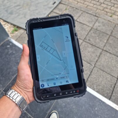
Comprehensive Surveying and Data Collecting Software
As a top-tier data collecting software, Spherefix enables precise measurements and efficient data handling. Whether you’re working on land development, topographic mapping, or construction layout, this software for data collecting streamlines the process with advanced surveying functionalities.
Advanced Coordinate System and Projection Capabilities
One of the standout features of this software is its compatibility with multiple coordinate systems and projection methods. This ensures that engineers and surveyors can perform accurate measurements worldwide, making it an indispensable land surveying field software.
Seamless CORS Account Integration for Real-Time Accuracy
Spherefix supports various types of CORS (Continuously Operating Reference Station) accounts, allowing for fixed solutions with an internet connection. With this feature, users can achieve real-time precision, enabling immediate measurements upon startup.
Ideal Field Software for Construction Projects
For professionals in the construction industry, Spherefix serves as an essential field software for construction. Its reliable features cater to site engineers, contractors, and surveyors who require construction field software that guarantees precise data collection and analysis.
Why Choose Spherefix Software?
- Multi-language support for global usability
- Comprehensive surveying functions for diverse industries
- Advanced coordinate system compatibility for worldwide applications
- Real-time fixed solutions with multiple CORS account support
- Reliable land surveying field software for professionals


Reviews
There are no reviews yet.