


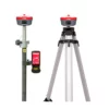
a-Geo L100 PRO Rover & Base set
a-Geo L100 PRO Rover & Base set
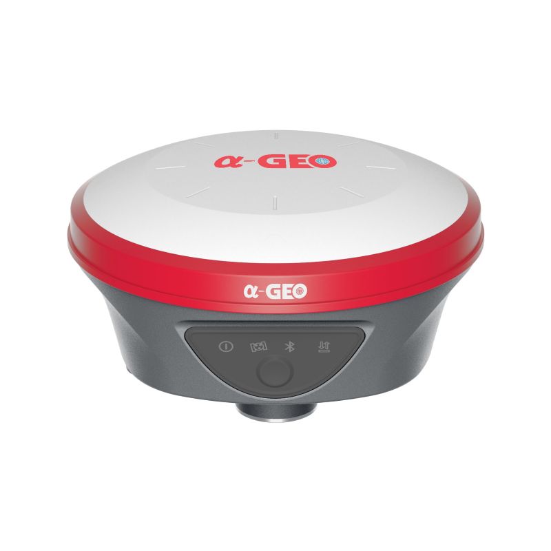
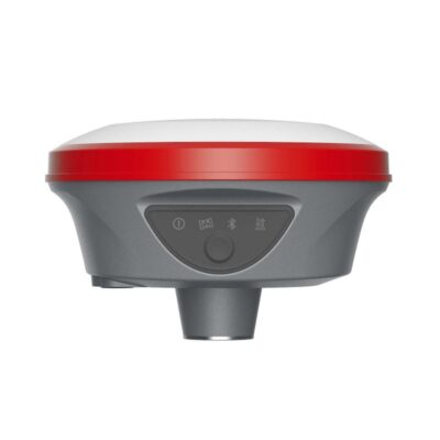
The a-Geo L100 PRO Rover & Base Set is a professional RTK GNSS solution for surveyors, construction teams, engineers, GIS users and field crews who need reliable centimetre-level positioning without depending only on a local RTK network. Built around the compact L100 PRO smart GNSS receiver, this rover and base setup supports full GNSS tracking, internal UHF radio, 4G connectivity, WebUI configuration and calibration-free IMU tilt measurement up to 120°.
This set is suitable for topographic surveys, construction layout, point collection, stakeout, road work, control measurements, static surveys and projects where an independent base-rover workflow is preferred.
| Receiver channels | 1408 tracking channels |
|---|---|
| GNSS support | GPS, GLONASS, BeiDou, Galileo, QZSS, SBAS, IRNSS |
| RTK accuracy | Horizontal 8 mm + 1 ppm RMS / Vertical 15 mm + 1 ppm RMS |
| Tilt measurement | IMU tilt up to 120°, calibration-free |
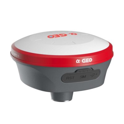
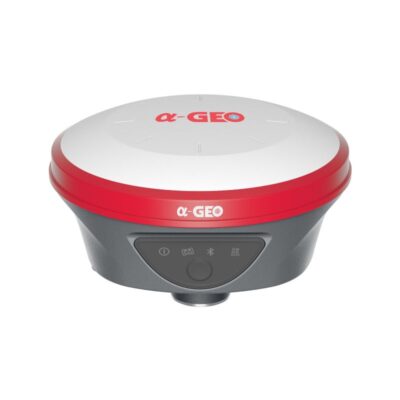
| Communication | 4G modem, WiFi, Bluetooth, USB-C, internal UHF radio |
| UHF range | Up to 15 km under optimal conditions |
| Battery | 7000 mAh internal lithium-ion battery |
| Field software | Compatible with SurPro6.0 Android surveying workflows |
Datasheets and manuals
Datasheets

Valued customers:


Find RTK Networks
Search NTRIP providers and connect to reliable RTK correction services.
Description
a-Geo L100 PRO Rover & Base set Product Review
a-Geo L100 PRO Rover & Base Set for professional RTK surveying
The a-Geo L100 PRO Rover & Base Set is a complete RTK GNSS solution for field teams who need accurate positioning, flexible correction options and a practical base-rover workflow. It is designed for surveyors, construction workers, engineers, GIS teams, drone ground control workflows and other professionals who need dependable GNSS performance on site.
With 1408 tracking channels, multi-constellation GNSS support, an integrated UHF radio, 4G internet connectivity and IMU tilt measurement up to 120°, the L100 PRO is built for demanding RTK work. The rover and base configuration gives you the freedom to work without relying only on a local RTK network. For projects where network corrections are available, the receiver can also be used in Network RTK workflows.
The a-Geo L100 PRO Rover & Base Set connects naturally into a complete GNSS workflow. The receiver handles the satellite tracking, RTK corrections and positioning, while field software such as SurPro6.0 supports day-to-day surveying tasks including point measurement, stakeout, CAD-based work, coordinate conversion, road design stakeout and data management.
Key advantages
- Rover and base RTK setup for independent site work
- 1408-channel GNSS board with support for all major constellations
- Centimetre-level RTK accuracy for surveying and construction layout
- Internal UHF radio with selectable frequency range from 410 MHz to 470 MHz
- Integrated 4G modem for Network RTK and internet-based correction services
- Calibration-free IMU tilt measurement up to 120° for faster point collection
- WiFi hotspot and WebUI for configuration, status checks and raw data download
- Rugged IP67 magnesium alloy housing for field use
- USB Type-C charging and internal 7000 mAh battery
Built for rover and base RTK workflows
A rover and base set is useful when you need your own correction source on site. The base receiver is set up over a known or measured point and transmits correction data to the rover. This allows the rover to calculate high-precision positions in real time, making it suitable for construction sites, land surveying projects, infrastructure work and remote areas where an RTK network may not be available or reliable.
The L100 PRO supports multiple working modes, including Network RTK, UHF RTK, Static and PPK workflows. This makes the system flexible for both real-time field layout and post-processing tasks. For everyday users, this means the same receiver can be used for quick RTK measurements, control work, site staking and static observation sessions depending on project requirements.
Full GNSS tracking for reliable positioning
The a-Geo L100 PRO tracks GPS, GLONASS, BeiDou, Galileo, QZSS, SBAS and IRNSS signals. With 1408 tracking channels, the receiver is designed to use a wide range of available satellite signals, helping improve satellite availability and RTK reliability in normal field conditions.
For surveyors and construction users, strong multi-constellation tracking is important when working around buildings, trees, machines or other obstacles that can reduce sky visibility. More usable satellites can help the receiver maintain a stable solution and reduce waiting time during fieldwork.
IMU tilt measurement up to 120°
The L100 PRO includes an IMU tilt sensor that is fast to initialize, calibration-free and not affected by magnetic interference in the same way as compass-based tilt systems. The receiver supports tilt measurement up to 120°, allowing users to measure or stake points when the pole cannot be held perfectly vertical.
This is especially useful near walls, fences, building corners, trenches, road edges, parked equipment and other locations where setting the pole directly over the point is difficult. In practical fieldwork, tilt compensation helps reduce repeated setups and makes point collection faster.
Internal UHF radio and 4G connectivity
The a-Geo L100 PRO is equipped with an internal UHF radio for base-rover RTK communication. The radio operates in the 410 MHz to 470 MHz frequency range and supports selectable frequencies. Under optimal conditions, the datasheet specifies a working range of up to 15 km with a 1/2 W transmit power.
For projects where internet corrections are preferred, the integrated multi-band 4G modem supports cellular communication. This allows the receiver to work with correction services through Network RTK workflows. The combination of UHF and 4G makes the L100 PRO Rover & Base Set flexible for both local base station work and network correction workflows.
WiFi hotspot and WebUI receiver management
The L100 PRO can act as a WiFi hotspot. Users can connect to the receiver with a smartphone, tablet or computer to access the WebUI. Through the WebUI, it is possible to manage receiver settings, monitor status and download static or PPK raw data without needing a cable or extra desktop software for basic receiver access.
This is useful for field crews who want to check receiver status quickly, configure settings, or retrieve observation files after a static or PPK session.
Rugged receiver for daily field use
The receiver uses a magnesium alloy body and has an IP67 protection rating. It is protected against dust and can withstand temporary immersion up to a depth of 1 metre for 30 minutes. The L100 PRO is also specified to survive a 2 metre drop onto concrete.
For everyday surveying and construction work, this rugged design helps protect the receiver against dust, rain, mud, transport wear and accidental knocks on site.
Long battery life and USB-C charging
The L100 PRO has an internal 7000 mAh lithium-ion battery and supports USB Type-C fast charging. Battery life depends on the working mode. The datasheet specifies up to 15 hours in rover mode, 7 hours in base mode and 17 hours in static mode.
This makes the receiver suitable for full field days when used as a rover, while base mode battery planning should take the shorter base operating time into account. For longer base station sessions, external power support is available through the receiver power interface.
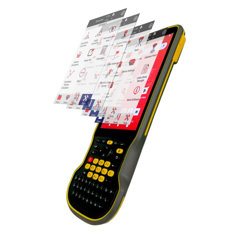
SurPro6.0 field software workflow
SurPro6.0 is Android-based field surveying software developed for high-precision GNSS measurement and engineering surveying workflows. It supports the practical tools that surveyors and construction users need in the field, including project management, device connection, rover setup, base setup, static mode, point measurement, stakeout, coordinate conversion and CAD functions.
For field teams, the most important benefit is that receiver operation and measurement work are connected in one workflow. You can configure the GNSS receiver, manage projects, collect points, stake known coordinates, work with coordinate systems, import and export point data and use CAD tools directly in the field.
Important SurPro6.0 functions for surveying and construction
| Project management | Create and manage projects, store project files, manage coordinate systems and project data. |
|---|---|
| Localization | Calculate and apply conversion parameters using control points for local project coordinates. |
| Point database | Add, delete, import, export and manage measured points and control points. |
| Code library | Use preset codes for faster field data collection and feature attribution. |
| Rover setup | Configure mobile station workflows for receiving correction data and obtaining high-precision positions. |
| Base setup | Configure the receiver as a reference station and broadcast correction data to the rover. |
| Static mode | Use the receiver for static observation workflows where required. |
| Point measurement | Collect field points with configurable measurement settings, codes and antenna height input. |
| Control point survey | Measure higher-confidence control points using repeated observations and result checks. |
| Point stakeout | Stake known coordinates in the field with target direction and deviation guidance. |
| CAD functions | Use CAD drawing tools, layers, DXF/DWG import, DXF export, CAD calculations and CAD stakeout. |
| Line stakeout | Stake designed lines point by point using mileage, offsets and height differences. |
| DSM stakeout | Use site elevation data for cut-and-fill style elevation guidance. |
| Road design stakeout | Work with road alignment, vertical curve, chain break, cross section and slope design functions. |
| Tools | Coordinate converter, angle converter, perimeter and area calculation and calculator functions. |
Technical specifications
GNSS performance
| Satellite signals tracked simultaneously | GPS: L1C/A, L1C, L2P(Y), L2C, L5 GLONASS: L1, L2, L3 BeiDou: B1I, B2I, B3I, B1C, B2a, B2b Galileo: E1, E5a, E5b, E6 QZSS: L1, L2, L5, L6 SBAS: L1, L5 IRNSS: L5 |
|---|---|
| Channels | 1408 tracking channels |
| Cold start | < 60 s |
| Hot start | < 15 s |
| Positioning output rate | 1 Hz – 20 Hz |
| Signal reacquisition | < 1 s |
| RTK initialization time | < 10 s |
| Initialization reliability | > 99.99% |
| Time accuracy | 20 ns |
Positioning accuracy
| Code differential GNSS positioning | Horizontal: 0.25 m + 1 ppm RMS Vertical: 0.50 m + 1 ppm RMS |
|---|---|
| SBAS differential positioning accuracy | Typically < 5 m 3DRMS |
| Static GNSS surveying | Horizontal: 2.5 mm + 0.5 ppm RMS Vertical: 5 mm + 0.5 ppm RMS |
| Single baseline < 30 km | Horizontal: 8 mm + 1 ppm RMS Vertical: 15 mm + 1 ppm RMS |
| Network RTK | Horizontal: 8 mm + 0.5 ppm RMS Vertical: 15 mm + 0.5 ppm RMS |
Physical specifications
| Material | Magnesium alloy |
|---|---|
| Dimensions | 131 × 64 mm |
| Weight | 0.76 kg |
| Operating temperature | -40°C to +75°C |
| Storage temperature | -55°C to +85°C |
| Protection rating | IP67 dustproof, protected from 30 min immersion to depth of 1 m |
| Shock | Survive 2 m drop onto concrete |
| Vibration | MIL-STD-810G |
| Humidity | 100%, condensing |
Power
| External power | 9-24 VDC external power |
|---|---|
| USB Type-C fast charging | Supported |
| Battery capacity | Internal 7000 mAh lithium-ion battery |
| Battery life – rover mode | 15 hours |
| Battery life – base mode | 7 hours |
| Battery life – static mode | 17 hours |
Communication and data storage
| LEMO port | 5-pin, supports power input, serial port control and external radio communication |
|---|---|
| USB Type-C port | Charging |
| SIM card slot | Supports nano-SIM |
| Antenna port | UHF antenna interface |
| Radio modem | Internal UHF radio |
| Transmit power | 1/2 W selectable; working range up to 15 km under optimal conditions |
| Frequency band | 410 MHz – 470 MHz, supports frequency selection |
| Radio protocols | AlphaTalk15, TrimTalk450s, SOUTH, SatelPCC-EOT |
| Cellular | Integrated full-frequency multi-band 4G modem, supports WCDMA/CDMA2000/TDD-LTE/FDD-LTE |
| WiFi | 802.11 b/g standard, access point and client mode, supports hotspot access for correction transmission |
| Bluetooth | Integrated Bluetooth V5.2, range ≤ 50 m |
| Data format | RTCM2.x, RTCM3.x, CMR & CMR+, SCMRx, data, RINEX, NMEA outputs |
| Storage | 8 GB internal memory, supports cyclic storage; can collect over one year of raw observations at 5-second interval |
System and operation
| Operating system | Intelligent Linux operating system |
|---|---|
| Tilt compensation | IMU up to 120°, calibration-free |
| Supported controllers | Android devices with supported software |
| Button | Power key |
| Indicators | Power indicator, data link indicator, satellite indicator, Bluetooth indicator |
| Voice | Intelligent voice prompts |
| WebUI | Supports WebUI configuration |
Applications
The a-Geo L100 PRO Rover & Base Set is suitable for a wide range of professional GNSS tasks. It is especially useful when users need both a rover and a local base station for independent RTK operation.
- Topographic surveying and mapping
- Construction layout and site preparation
- Road and infrastructure projects
- Point collection and GIS field data capture
- Control point measurement
- Boundary, volume and terrain-related survey work
- Machine control support workflows where accurate control points are required
- Drone ground control point measurement
- Static GNSS observations and PPK workflows
- Stakeout of points, lines, CAD elements and road designs
Why buy from Global GPS Systems?
Global GPS Systems supplies professional GNSS equipment to surveyors, construction companies, engineers, GIS teams, drone operators and other field professionals worldwide. We ship from the Netherlands and help customers choose the right receiver, rover set or complete base-rover solution for their work.
When you buy the a-Geo L100 PRO Rover & Base Set from Global GPS Systems, you receive expert product advice, insured worldwide delivery, warranty and support with practical RTK workflows. Our team can help with field setup, correction services, import and export questions, and choosing compatible surveying software, data collectors and accessories.
FAQ
What is the a-Geo L100 PRO Rover & Base Set?
The a-Geo L100 PRO Rover & Base Set is a professional RTK GNSS solution based on the L100 PRO smart receiver. It is designed for users who want to work with a rover and local base station for centimetre-level GNSS positioning.
Can the a-Geo L100 PRO be used without an RTK network?
Yes. In a rover and base setup, one receiver can operate as the base station and send correction data to the rover through the internal UHF radio. This is useful on sites where no RTK network is available or where a local base is preferred.
Does the L100 PRO support Network RTK?
Yes. The receiver includes a 4G modem and supports Network RTK workflows when used with a suitable correction service and SIM/network configuration.
How accurate is the a-Geo L100 PRO in RTK mode?
For a single baseline under 30 km, the specified RTK accuracy is horizontal 8 mm + 1 ppm RMS and vertical 15 mm + 1 ppm RMS. For Network RTK, the specified accuracy is horizontal 8 mm + 0.5 ppm RMS and vertical 15 mm + 0.5 ppm RMS.
Does the a-Geo L100 PRO have tilt compensation?
Yes. The receiver supports calibration-free IMU tilt compensation up to 120°. This helps measure or stake points when the pole cannot be held perfectly vertical.
Which satellite constellations does the L100 PRO support?
The receiver tracks GPS, GLONASS, BeiDou, Galileo, QZSS, SBAS and IRNSS signals.
What is the radio range of the a-Geo L100 PRO?
The internal UHF radio has a specified working range of up to 15 km under optimal conditions. Actual range depends on terrain, antenna setup, interference, frequency settings and local conditions.
Can the L100 PRO be used for static surveying?
Yes. The receiver supports static GNSS surveying and has internal storage for raw observation data.
What software can be used with this GNSS set?
The a-Geo L100 PRO Rover & Base Set can be used with Android surveying workflows such as SurPro6.0. SurPro supports receiver connection, rover setup, base setup, point measurement, stakeout, coordinate tools, CAD functions and road-related surveying functions.
Is this set suitable for construction layout?
Yes. The combination of RTK positioning, tilt measurement, point stakeout, line stakeout and CAD-related field tools makes it suitable for construction layout, site control and infrastructure work.
Is the a-Geo L100 PRO rugged enough for field use?
Yes. The receiver has a magnesium alloy body, IP67 protection, MIL-STD-810G vibration rating and is specified to survive a 2 m drop onto concrete.
Does Global GPS Systems ship this product internationally?
Yes. Global GPS Systems offers worldwide shipping from the Netherlands with insured delivery. Our team can also assist with import/export questions, warranty, RTK setup and product advice.
Reviews (0)
Only logged in customers who have purchased this product may leave a review.
Find RTK Networks
Search NTRIP providers and connect to reliable RTK correction services.

Reviews
There are no reviews yet