Alpha 400 Rover & Base set Product Review
Below you will find a complete overview of the Alpha 400 Rover & Base set.
Alpha 400 Rover & Base Set – Precision GNSS System for Professional Surveying and Mapping
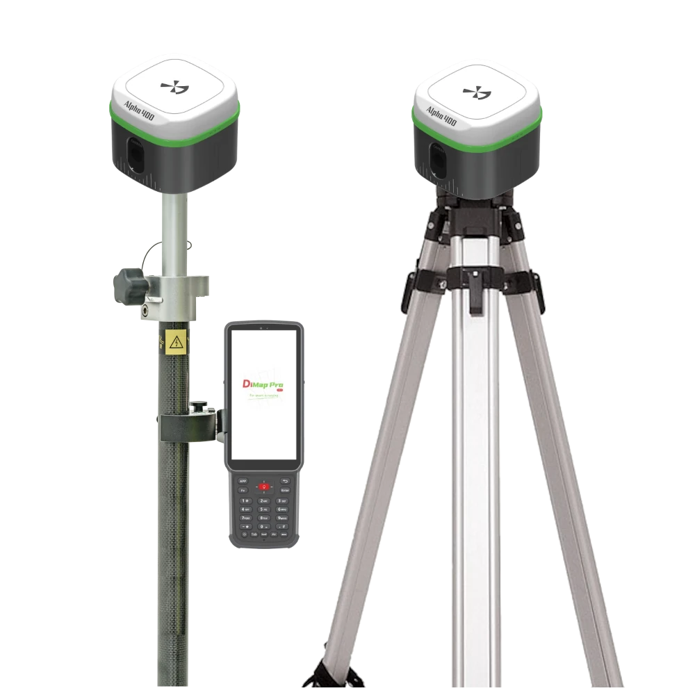
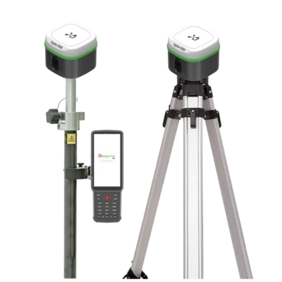
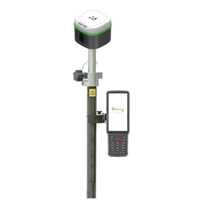
The Alpha 400 Rover & Base set is an advanced GNSS surveying system built to deliver unmatched accuracy, intelligent performance, and all-day reliability. Designed for professionals in land surveying, construction, and geospatial mapping, this complete set combines the Alpha 400 GNSS Rover and Base unit with the B55 Data Collector and DiMap Pro software — offering everything you need for precision fieldwork in one powerful package.
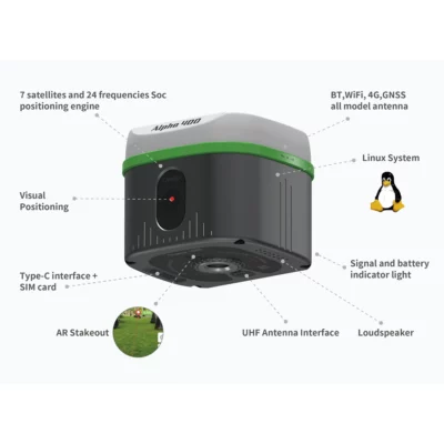
Featuring a 7-satellite, 24-frequency SoC positioning engine, the Alpha 400 Rover & Base set ensures stable signal tracking, ultra-fast positioning, and centimeter-level accuracy. Whether you’re conducting control point surveys, AR stakeouts, or high-precision CAD mapping, this GNSS-based system gives you confidence in every measurement.
Integrated Visual Positioning and Real-Time AR Stakeout
The Alpha 400 Rover & Base set redefines field precision with its visual positioning RTK technology. By integrating GNSS, IMU, and optical sensors, it enables real-time, tilt-compensated measurements with an impressive 2cm accuracy — even at angles up to 60°.
With AR visual stakeout capability, the Alpha 400 allows users to see stakeout points overlaid directly onto the real-world environment. Its professional camera and advanced image processing engine provide crystal-clear visualization under any lighting condition — from bright sunlight to low-light environments.
Simply tap the screen to measure; the system automatically calculates real-time coordinates with 1cm visual accuracy, offering a fast and intuitive way to perform field stakeouts and boundary marking.

High-End Design, Connectivity, and Performance
Engineered for field endurance and usability, the Alpha 400 Rover & Base set features a rugged, lightweight body with the latest technology to support continuous field operations. It includes:
-
BT, Wi-Fi, 4G, and GNSS antennas for seamless communication.
-
A Linux operating system for stability and customization.
-
Type-C and SIM card interfaces, plus a UHF antenna port for long-range communication.
-
Signal and battery indicators for quick monitoring.
-
A loudspeaker for voice prompts and alerts during surveying.
With its 2W internal UHF radio transceiver, the base station maintains reliable communication with the rover, ensuring uninterrupted data transmission even across challenging terrains.
The long-lasting battery performance allows up to 18 hours in CORS mode, 15 hours in radio receiving, and 8 hours in transmitting, enabling surveyors to work a full day without downtime.
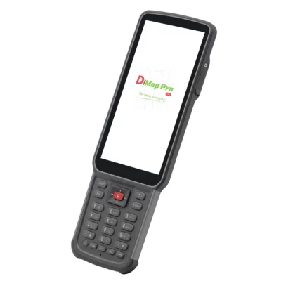
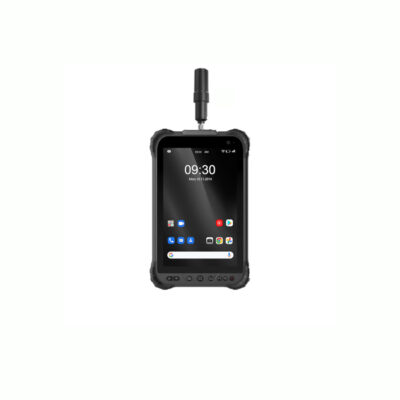
Professional Data Collection and Mapping with B55 & DiMap Pro
The Alpha 400 Rover & Base set comes equipped with the B55 Data Collector and DiMap Pro software, providing a complete suite for data acquisition, processing, and CAD mapping. This combination enables seamless execution of:
-
Point, detail, and control point surveys
-
CAD mapping, stakeout, and road layout
-
Electric lines, DSM, and photovoltaic stakeouts
-
Polyline, polygon, and spiral stakeouts
-
Electric tower and infrastructure stakeouts
The DiMap Pro software features a powerful CAD engine capable of handling files larger than 100MB, supporting multiple layers, text encodings, and real-time rendering. It also includes background layer setup, offset corrections, and tilt measurement validation, ensuring precise and error-free data output.
Additionally, DiMap Pro supports Amap and other mapping platforms, offers post-test corrections, customizable functions, and a built-in calculator — empowering surveyors to optimize every aspect of their workflow.
5 Key Advantages of the Alpha 400 Rover & Base Set
-
2cm GNSS accuracy and 1cm AR visual stakeout precision in all field conditions.
-
Integrated Rover and Base system for stable, high-speed RTK performance.
-
B55 Data Collector and DiMap Pro software for advanced CAD mapping.
-
18-hour battery life and rugged, field-ready design for maximum uptime.
-
Fully compatible communication system with 2W UHF radio and 4G connectivity.
Unmatched GNSS Accuracy and Reliability
The Alpha 400 Rover & Base set provides unparalleled positioning precision through its advanced GNSS technology. With temperature compensation algorithms and instant fix capabilities, the system maintains performance even in dynamic environments or when facing signal obstruction.
Its photoelectric measuring system ensures consistent accuracy, while inertial navigation enables smooth, calibration-free operation. Just take a few steps, and the rover automatically enters inertial navigation mode — no setup required.
Whether used for geodetic surveys, mapping projects, or infrastructure layouts, the Alpha 400 Rover & Base set ensures professional results and faster project completion times.
Why Choose the Alpha 400 Rover & Base Set?
If you’re looking for a complete GNSS Rover and Base solution that delivers precision, efficiency, and reliability, the Alpha 400 Rover & Base set stands out as the ultimate choice. With AR stakeout visualization, intelligent data collection, and full CAD compatibility, it streamlines complex workflows and enhances on-site productivity.
Professionals across surveying, mapping, and construction industries rely on this GNSS-based system for its unmatched performance and easy usability.


 Channels
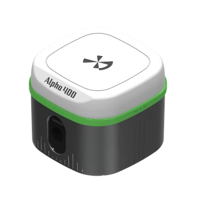


Reviews
There are no reviews yet.