a-GEO Matrix 2 Rover and Base set Product Review
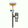
a-GEO Matrix 2 RTK GNSS Receiver
The a-GEO Matrix 2 RTK GNSS Receiver is a next-generation, compact, and smart laser AR RTK designed for precision in any surveying project. Equipped with cutting-edge GNSS technology, this versatile device features Bluetooth, Internal Radio, Wi-Fi, and a 4G modem, along with a powerful 7000mAh built-in battery and advanced IMU tilt compensation. Ideal for professionals seeking a GNSS receiver for land surveying and construction, the a-GEO Matrix 2 ensures unmatched accuracy and efficiency.
| ✅ Channels |
1408 |
| ✅ IMU Tilt Sensor |
60º |
| ✅ Internet Modem |
4G |
| ✅ UHF Radio |
410 – 470MHz |
| GPS |
L1C/A, L1C, L2C, L2P(Y), L5 |
| GLONASS |
L1, L2, L3 |
| GALILEO |
E1, E5a, E5b, E6 |
| BEIDOU |
B1I, B2I, B3I, B2a, B2b |
Revolutionize Your Surveying Workflow with the a-GEO Matrix 2 Rover and Base Set
The a-GEO Matrix 2 rover and base set is the ultimate solution for professionals in need of precision, reliability, and efficiency. Designed with state-of-the-art GNSS technology, this compact and intelligent system is perfect for land surveying and construction projects. Whether you’re mapping terrains, setting boundaries, or planning infrastructure, the a-GEO Matrix 2 ensures accuracy and ease like never before.
Unparalleled Accuracy with Advanced Features
Cutting-Edge GNSS Technology
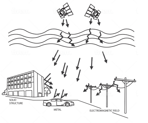
The a-GEO Matrix 2 GNSS rover and base set is equipped with the latest GNSS technology, providing real-time kinematic (RTK) precision even in challenging environments. Its ability to maintain accuracy in dense urban areas or under tree canopies makes it indispensable for demanding projects.
IMU Tilt Compensation for Enhanced Flexibility
Gone are the days of painstakingly leveling your rover. With IMU tilt compensation, you can measure points accurately even when the pole is tilted. This feature not only saves time but also reduces the risk of errors, ensuring seamless workflows on-site.
All-in-One Connectivity
Stay connected with built-in Bluetooth, internal radio, Wi-Fi, and a 4G modem. These features ensure smooth data transfer and reliable communication between the rover and base, keeping your operations uninterrupted.
Long-Lasting Performance
Powered by a robust 7000mAh built-in battery, the a-GEO Matrix 2 GNSS rover and base set delivers extended operational time, letting you work longer without interruptions. Its durable design ensures it withstands harsh conditions, making it an ideal companion for fieldwork.
Solve Your Surveying Struggles
Struggle with Precision in Complex Environments?
This GNSS set excels where others fail. Its GNSS capabilities and IMU tilt sensor ensure accurate readings, even in environments where traditional systems fall short.
Tired of Time-Consuming Setups?
Thanks to its IMU tilt compensation and intuitive design, the a-GEO Matrix 2 reduces setup time and streamlines your surveying process. Spend less time setting up and more time getting results.
Need a Reliable System for Construction and Surveying?
This GNSS set for construction and surveying is specifically engineered for professionals. Its robust build and superior performance ensure your construction and surveying projects stay on track with minimal downtime.
Why Choose the a-GEO Matrix 2 Rover and Base Set?
- Unmatched Accuracy: Advanced GNSS technology delivers pinpoint precision.
- Efficient Workflows: IMU tilt compensation simplifies measurements.
- Comprehensive Connectivity: Bluetooth, Wi-Fi, and 4G keep you connected.
- Extended Battery Life: Work without interruptions, even on long days.
- Versatile Applications: Perfect for land surveying and construction.
Comprehensive Accessories for Enhanced Versatility
The a-GEO Matrix 2 rover and base set comes complete with all the essential accessories to maximize your efficiency and adaptability in the field:
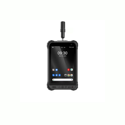
- a-GEO S50III Data Collector: The a-GEO S50III data collector is a robust and reliable device for managing your survey data.
- SurPro Surveying Software: The SurPro Software is an intuitive software solution that streamlines your workflow and ensures precise results.
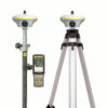
- Surveying Pole and Data Collector Bracket: For convenient and stable operation during surveys.
- Tripod, Tribrach, and Adapter: Ensures stability and accuracy for fixed-point measurements.
Customizable Accessories for Your Needs
The Matrix 2 rover and base set is flexible to match your specific requirements. Prefer using a tablet instead of the included controller? Or need different software for your workflow? These accessories can be easily modified or upgraded to suit your preferences, ensuring the perfect fit for your projects.


Reviews
There are no reviews yet.