South Supreme ME Product Review
South Supreme ME GNSS + SLAM LiDAR System – Hybrid Surveying Without Limits
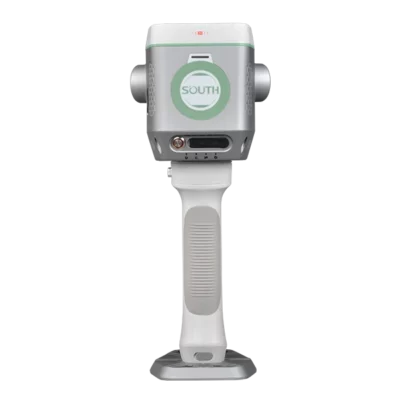
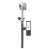
The South Supreme ME is a next-generation hybrid surveying platform that merges the accuracy of GNSS RTK positioning with the versatility of SLAM LiDAR scanning. By combining these technologies into a single, fully integrated system, surveyors can confidently operate in environments that were previously inaccessible or impossible to measure. The ME system supports seamless indoor-outdoor workflows, efficient operation in confined or hazardous spaces and reliable data collection even where satellite visibility is limited or absent.
At the heart of the system is an intelligent fusion of GNSS, LiDAR, IMU, high-resolution cameras and a professional NVIDIA graphics processor. This combination makes it possible to generate realistic 3D models, accurate coordinate outputs, colored point clouds and AR-supported measurement data in real time. The resulting workflow is significantly faster and more efficient than traditional laser RTK or visual RTK surveying methods.
Air Meas. – High-Speed Capture Without Stopping or Aiming
The Air Meas. feature enables rapid data capture by pairing advanced laser sensors with AI-driven image recognition. The system can collect up to 200,000 measurement points per second, allowing the operator to move freely without pausing, leveling the pole or precisely directing the sensor. A single action captures numerous 3D coordinates instantly, dramatically reducing surveying time.
With a working range of 15 meters and an accuracy of approximately 5 cm, the South Supreme ME is particularly valuable in environments such as excavation pits, steep embankments, bridge structures and other locations where traditional equipment is unsafe or impractical. This capability accelerates project delivery and expands the range of measurable environments.
Integrated Multi-Sensor Technology
The South Supreme ME integrates all essential components required for advanced surveying into one compact platform. Its GNSS module supports 1698 channels and includes an IMU, UHF radio, network module and Bluetooth connectivity. The LiDAR system provides high-precision scanning with reliable detection performance, suitable for indoor navigation, mapping and complex geometric environments. Four onboard cameras enable real-time color visualization, photogrammetry and visual stakeout tasks, while the NVIDIA processor ensures fast rendering and smooth point cloud processing.
Continuous Operation With Uninterrupted Power Management
The South Supreme ME system is designed for uninterrupted field operation. Power can be supplied through the internal battery, a battery grip or an external power source. Switching between power inputs does not interrupt the surveying session, which is essential for large projects, long-duration scanning missions or time-sensitive workflows. This capability ensures consistent performance throughout the entire measurement process.
Magicalc – Reliable Performance in GNSS-Denied Environments
The Magicalc function allows the South Supreme ME to maintain approximately 5 cm accuracy for several minutes when GNSS signals become unavailable. During this period the system transitions from a fixed solution to a mixed-solution mode while still providing usable and reliable measurements. This is ideal for working under bridges, in tunnels, parking structures or other GNSS-limited environments where traditional receivers lose functionality entirely.
3D Volume and Terrain Modeling
The South Supreme ME generates detailed 3D point clouds that can be used for volume calculations, terrain modeling and analytical tasks. This capability supports excavation and fill determination, stockpile measurement, mining workflows and civil engineering projects. The detailed visualization and modeling enhance accuracy and enable fast decision-making in demanding industrial environments.
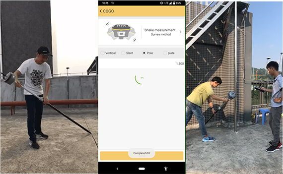
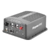
H9 Data Collector – Optimized for SLAM and Photogrammetry
The H9 Data Collector is designed to support real-time SLAM and photogrammetry processing. Its high-performance processor, long-lasting battery and intuitive interface ensure smooth field operation, while the large touchscreen and integrated keyboard improve usability in demanding conditions. Running on Android 12, the device supports modern applications and provides efficient task execution for field teams.
AcuteLas Studio – Advanced Office Software
AcuteLas Studio provides powerful tools for post-processing 3D laser scan and LiDAR data. Its features enable automated trajectory processing, point cloud fusion, classification, accuracy assessment and reporting. Additional modules support coordinate transformation and the creation of topographic deliverables, ensuring that field data can be efficiently converted into professional survey outputs.
Top 5 Advantages of the South Supreme ME
-
Capture up to 200,000 points per second with approximately 5 cm accuracy
-
Maintain measurement capability in GNSS-denied areas using Magicalc mixed-solution technology
-
Fully integrated GNSS, LiDAR, IMU, camera system and NVIDIA processing in one platform
-
Continuous operation with seamless power switching and no workflow interruption
-
Ideal for complex, hazardous or difficult-to-access environments


Reviews
There are no reviews yet.